Select location of well to view details.
Click on column heading to sort.
|
|
|
County: Dickinson Select location of well to view details. Click on column heading to sort. |
|
|
|
| View page: < Prev || 21 || 22 || 23 || 24 || 25 || 26 || 27 || 28 || 29 || 30 || Next > | |||||||||
| T-R-S | Owner | Well Depth Ascend. Desc. |
Static Water Level Ascend. Desc. |
Est. Yield Ascend. Desc. |
Well Use | Other ID | Action Taken | Completion Date Ascend. Desc. |
Scan? |
|
T13S, R2E, Sec. 7 SW SW SE |
Koss Construction | 92 ft. | 9 ft. | 142.5 gpm. | Other | Constructed | 19-Aug-2005 | ||
|
T13S, R2E, Sec. 7 C NW SW |
Malan Construction | 37.83 ft. | 25.5 ft. | Monitoring well/observation/piezometer | Plugged | 29-Dec-2006 | |||
|
T13S, R2E, Sec. 7 SW NW SW |
Malan Construction | 38 ft. | 27 ft. | Monitoring well/observation/piezometer | Plugged | 29-Dec-2006 | |||
|
T13S, R2E, Sec. 7 NE SE SW |
Russell Stover Candies | 33 ft. | 4 ft. | Irrigation | Plugged | 21-Dec-1993 | |||
|
T13S, R2E, Sec. 7 NE SE SW |
Spangler, Don | 42 ft. | 14 ft. | 30 gpm. | Domestic | Constructed | 14-Sep-1987 | ||
|
T13S, R2E, Sec. 8 NE NE NE |
Barlow, Dan | 79 ft. | 29 ft. | 15 gpm. | Domestic | Constructed | 27-Aug-2010 | ||
|
T13S, R2E, Sec. 8 NE SE SE |
Barlow, Dan | 50 ft. | 10 ft. | 15 gpm. | Domestic | Constructed | 20-Nov-1993 | ||
|
T13S, R2E, Sec. 8 SE NE NE |
Brown, Ted | 62 ft. | 24 ft. | 8.5 gpm. | Domestic | Constructed | 13-May-1986 | ||
|
T13S, R2E, Sec. 8 SE NW NW |
Budden, Bradley | 70 ft. | 35 ft. | 20 gpm. | Domestic | Constructed | 06-Jul-1978 | ||
|
T13S, R2E, Sec. 8 NW NE SW |
Hafner, Brett | 65 ft. | 24 ft. | 15 gpm. | Domestic | Constructed | 09-Jul-1980 | ||
|
T13S, R2E, Sec. 8 SW SW NE |
Hafner, J. | 56 ft. | 10 ft. | 25 gpm. | Domestic | Constructed | 29-Jan-1987 | ||
|
T13S, R2E, Sec. 8 NW NW NE |
Houston, Larry | 47 ft. | 17 ft. | 8 gpm. | Domestic | Constructed | 22-Feb-2006 | ||
|
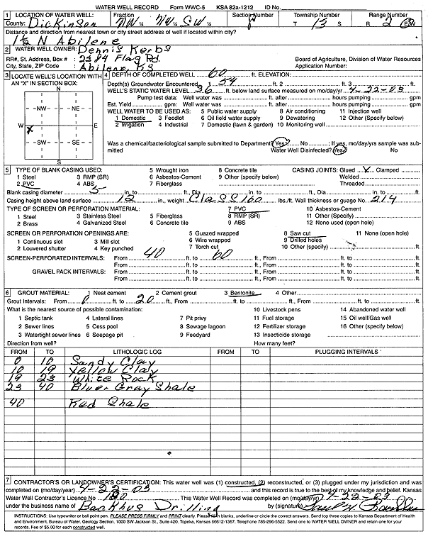
T13S, R2E, Sec. 8 NW NW SW |
Kerbs, Dennis | 60 ft. | 36 ft. | Domestic | Constructed | 22-Apr-2003 | Scan | ||
|
T13S, R2E, Sec. 8 NW SW SW |
Mohler, Jack | 80 ft. | 46 ft. | 20 gpm. | Domestic | Constructed | 20-Feb-1990 | ||
|
T13S, R2E, Sec. 8 SE SW NW |
Morabito, Dan | 57 ft. | 17 ft. | 13 gpm. | Domestic | Constructed | 15-Sep-1994 | ||
|
T13S, R2E, Sec. 8 NE NE SE |
Reynolds, Vern | 134 ft. | 50 ft. | 5 gpm. | Domestic | Constructed | 16-Feb-1989 | ||
|
T13S, R2E, Sec. 8 SW SW SE |
Robertson, Rees | 43 ft. | 21 ft. | 16 gpm. | Irrigation | Constructed | 22-Oct-1976 | ||
|
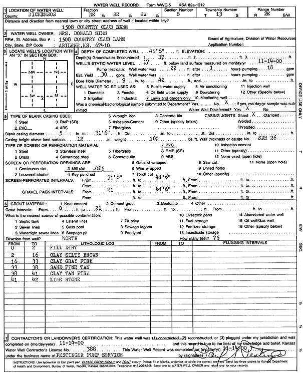
T13S, R2E, Sec. 8 NE SE SW |
Sims, Mrs. Donald | 41.5 ft. | 17 ft. | 30 gpm. | Domestic, Lawn and Garden | Constructed | 14-Nov-2000 | Scan | |
|
T13S, R2E, Sec. 8 SW SW SW |
Soelter, Bob | 80 ft. | 38 ft. | 20 gpm. | Domestic | Constructed | 29-Aug-1988 | ||
|
T13S, R2E, Sec. 8 SW SW SW |
Soelter, Robert | 98.7 ft. | 35.8 ft. | Domestic | Plugged | 23-Sep-1998 | |||
|
T13S, R2E, Sec. 8 NE NE NE |
Spillane, Maurice | 75 ft. | 40 ft. | 4.5 gpm. | Domestic | Constructed | 13-Jun-1992 | ||
|
T13S, R2E, Sec. 8 NE NE NE |
Spillane, Maurice | 79 ft. | 45 ft. | 11 gpm. | Domestic | Constructed | 21-Dec-1987 | ||
|
T13S, R2E, Sec. 8 SW SW SW |
Thayer, Jon D. | 60 ft. | 28 ft. | 30 gpm. | Domestic | Constructed | 17-Sep-1992 | ||
|
T13S, R2E, Sec. 8 SE SW |
Wattelet, Frank | 50 ft. | 20 ft. | 9 gpm. | Irrigation | Constructed | 09-Aug-1975 | ||
|
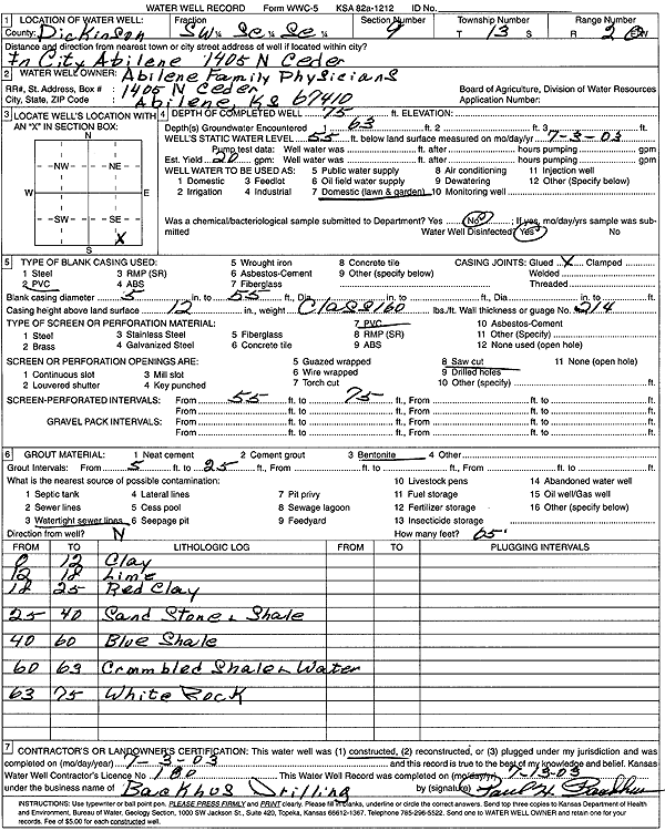
T13S, R2E, Sec. 9 SE SW SE SW |
Abilene Family Physicians | 75 ft. | 55 ft. | 20 gpm. | Domestic, Lawn and Garden | Constructed | 03-Jul-2003 | Scan | |
|
T13S, R2E, Sec. 9 SE SE NE |
Amoco Corp. | 46 ft. | Monitoring well/observation/piezometer | MW 12 | Constructed | 20-Feb-1998 | |||
|
T13S, R2E, Sec. 9 SE SE NE |
Amoco Corp. | 45 ft. | Monitoring well/observation/piezometer | MW 9 | Constructed | 20-Feb-1998 | |||
|
T13S, R2E, Sec. 9 SE SE NE |
Amoco Corp. | 50 ft. | Monitoring well/observation/piezometer | MW 10 | Constructed | 20-Feb-1998 | |||
|
T13S, R2E, Sec. 9 SE SE NE |
Amoco Corp. | 55 ft. | Monitoring well/observation/piezometer | MW 8 | Constructed | 20-Feb-1998 | |||
|
T13S, R2E, Sec. 9 SW SW NW |
Amoco Corp. | 42 ft. | Monitoring well/observation/piezometer | MW 16 | Constructed | 20-Feb-1998 | |||
|
T13S, R2E, Sec. 9 SE SE NE |
Amoco Corp. | 45 ft. | Monitoring well/observation/piezometer | MW 14 | Constructed | 20-Feb-1998 | |||
|
T13S, R2E, Sec. 9 SE SE NE |
Amoco Corp. | 42.2 ft. | Monitoring well/observation/piezometer | EMW 11 | Plugged | 02-May-2012 | |||
|
T13S, R2E, Sec. 9 SE SE NE |
Amoco Corp. | 46 ft. | Monitoring well/observation/piezometer | MW 13 | Constructed | 20-Feb-1998 | |||
|
T13S, R2E, Sec. 9 SE SE NE |
Amoco Corp. | 46 ft. | Monitoring well/observation/piezometer | MW 11 | Constructed | 20-Feb-1998 | |||
|
T13S, R2E, Sec. 9 SE SE NE |
Amoco Corp. | 46 ft. | Monitoring well/observation/piezometer | MW 17 | Constructed | 20-Feb-1998 | |||
|
T13S, R2E, Sec. 9 SE SE NW |
Amoco Oil Co. | 28 ft. | Monitoring well/observation/piezometer | OW 6 | Constructed | 10-Oct-1989 | |||
|
T13S, R2E, Sec. 9 SE SE NW |
Amoco Oil Co. | 29 ft. | Monitoring well/observation/piezometer | OW 4 | Constructed | 10-Oct-1989 | |||
|
T13S, R2E, Sec. 9 SE SE NW |
Amoco Oil Co. | 28.5 ft. | Monitoring well/observation/piezometer | OW 2 | Constructed | 10-Oct-1989 | |||
|
T13S, R2E, Sec. 9 SE SE NW |
Amoco Oil Co. | 32.5 ft. | Monitoring well/observation/piezometer | OW 5 | Constructed | 10-Oct-1989 | |||
|
T13S, R2E, Sec. 9 SE SE NE |
Amoco Oil Co. | 32 ft. | Monitoring well/observation/piezometer | OW 1 | Plugged | 05-May-1998 | |||
|
T13S, R2E, Sec. 9 SE SE NE |
Amoco Oil Co. | 32 ft. | Monitoring well/observation/piezometer | OW 2 | Plugged | 05-May-1998 | |||
|
T13S, R2E, Sec. 9 SE SE NW |
Amoco Oil Co. | 31 ft. | Environmental Remediation, Recovery | SG 3 | Constructed | 10-May-1991 | |||
|
T13S, R2E, Sec. 9 SE SE NW |
Amoco Oil Co. | 34.8 ft. | Monitoring well/observation/piezometer | OW 1 | Constructed | 10-Oct-1989 | |||
|
T13S, R2E, Sec. 9 SE SE NW |
Amoco Oil Co. | 38 ft. | Monitoring well/observation/piezometer | OW 7 | Constructed | 10-Oct-1989 | |||
|
T13S, R2E, Sec. 9 SE SE NE |
Amoco Oil Co. | 32 ft. | Monitoring well/observation/piezometer | DMW 1 | Plugged | 05-May-1998 | |||
|
T13S, R2E, Sec. 9 SE SE NW |
Amoco Oil Co. | 44.82 ft. | 37.05 ft. | Monitoring well/observation/piezometer | MW 9 | Plugged | 15-Jun-2011 | ||
|
T13S, R2E, Sec. 9 SE SE NW |
Amoco Oil Co. | 47.31 ft. | 36.01 ft. | Monitoring well/observation/piezometer | MW 10 | Plugged | 15-Jun-2011 | ||
|
T13S, R2E, Sec. 9 SE SE NW |
Amoco Oil Co. | 42.57 ft. | 36.38 ft. | Monitoring well/observation/piezometer | MW 17 | Plugged | 15-Jun-2011 | ||
|
T13S, R2E, Sec. 9 SE SE NW |
Amoco Oil Co. | 42.09 ft. | 37.13 ft. | Monitoring well/observation/piezometer | MW 14 | Plugged | 15-Jun-2011 | ||
|
T13S, R2E, Sec. 9 SE SE NW |
Amoco Oil Co. | 44.21 ft. | 35.13 ft. | Monitoring well/observation/piezometer | MW 13 | Plugged | 15-Jun-2011 | ||
| View page: < Prev || 21 || 22 || 23 || 24 || 25 || 26 || 27 || 28 || 29 || 30 || Next > | |||||||||