Select location of well to view details.
Click on column heading to sort.
|
|
|
County: Doniphan Select location of well to view details. Click on column heading to sort. |
|
|
|
| View page: 1 || 2 || 3 || 4 || 5 || 6 || 7 || 8 || 9 || 10 || Next > | |||||||||
| T-R-S | Owner | Well Depth Ascend. Desc. |
Static Water Level Ascend. Desc. |
Est. Yield Ascend. Desc. |
Well Use | Other ID | Action Taken | Completion Date Ascend. Desc. |
Scan? |
|
T2S, R19E, Sec. 3 SE SE SE |
Gilmore, Shelby | 51 ft. | 31 ft. | 2 gpm. | Domestic | Constructed | 12-Mar-1976 | ||
|
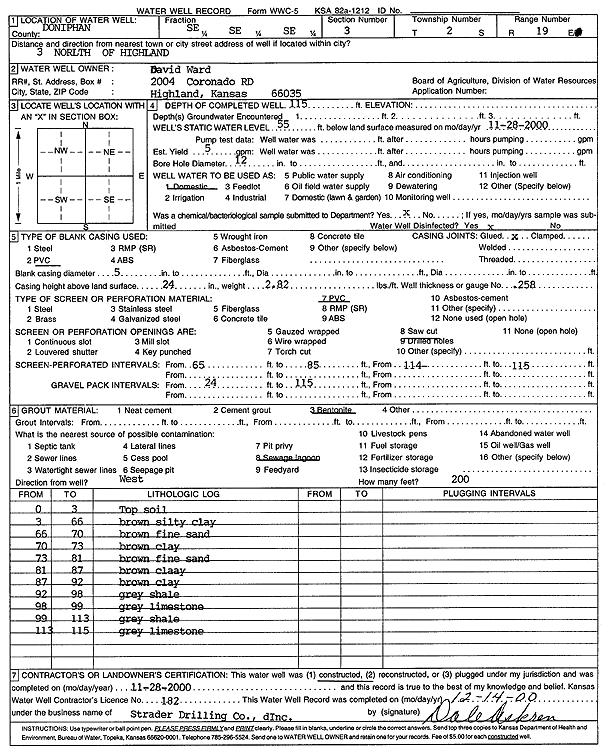
T2S, R19E, Sec. 3 SE SE SE |
Ward, David | 115 ft. | 55 ft. | 5 gpm. | Domestic | Constructed | 28-Nov-2000 | Scan | |
|
T2S, R19E, Sec. 5 NW SW SW |
Shonyo, Arnold | 34 ft. | 17 ft. | 12 gpm. | Domestic, Livestock | Constructed | 02-Oct-1975 | ||
|
T2S, R19E, Sec. 7 NE NE SE NW |
Doniphan Co. RWD 6 | 130 ft. | 64 ft. | 75 gpm. | Test hole/well | Constructed | 11-Oct-2011 | ||
|
T2S, R19E, Sec. 7 SE SE NE |
Rawles, Donald | 62 ft. | 45 ft. | 6 gpm. | Domestic | Constructed | 29-Sep-1975 | ||
|
T2S, R19E, Sec. 8 SE SE NE |
Scott, Jim | 150 ft. | 95 ft. | 60 gpm. | Domestic | Constructed | 10-Jun-1981 | ||
|
T2S, R19E, Sec. 10 SE SE SW |
Twombly, Robert | 54 ft. | 36 ft. | 7 gpm. | Domestic | Constructed | 26-Sep-1975 | ||
|
T2S, R19E, Sec. 11 NW NE SE |
Twombly, Scott | 191 ft. | 72 ft. | 150 gpm. | Domestic | Constructed | 29-Mar-2005 | ||
|
T2S, R19E, Sec. 13 NW SW SE |
Collins, Rudy | 30 ft. | 14 ft. | 5 gpm. | Domestic | Constructed | 17-Apr-1979 | ||
|
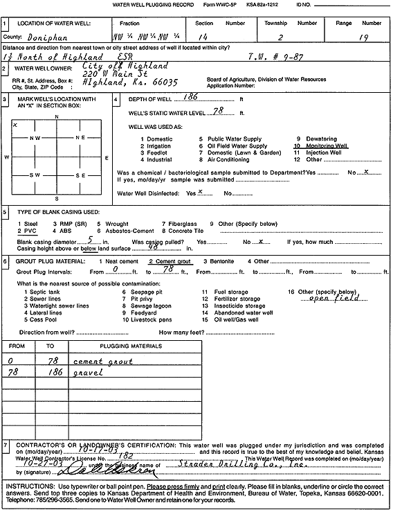
T2S, R19E, Sec. 14 NW NW NW |
City of Highland | 186 ft. | 78 ft. | Monitoring well/observation/piezometer | TW 9-87 | Plugged | 17-Oct-2003 | Scan | |
|
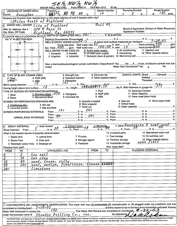
T2S, R19E, Sec. 14 SE NW NW |
City of Highland | 201 ft. | 82 ft. | 400 gpm. | Public Water Supply | Constructed | 18-Jul-2003 | Scan | |
|
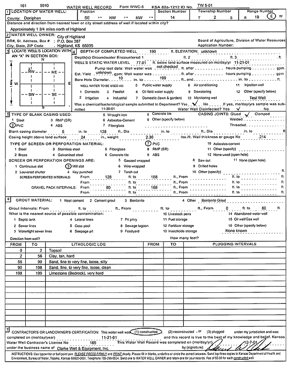
T2S, R19E, Sec. 14 SE NW NW |
City of Highland | 190 ft. | 77.01 ft. | Test hole/well | TW-5-01 | Constructed | 21-Nov-2001 | Scan | |
|
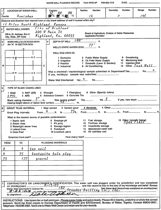
T2S, R19E, Sec. 14 SE NW NW |
City of Highland | 188 ft. | 77 ft. | Test hole/well | Plugged | 15-Aug-2003 | Scan | ||
|
T2S, R19E, Sec. 14 SW NW NW |
City of Highland | 210 ft. | 84.6 ft. | 250 gpm. | Public Water Supply | Constructed | 06-May-1988 | ||
|
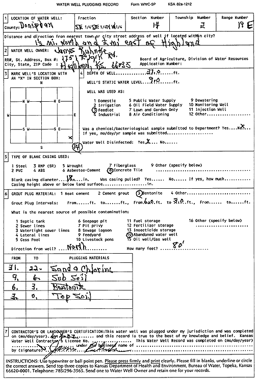
T2S, R19E, Sec. 14 SE SE NW |
Ruhnke, James | 31 ft. | 9 ft. | Domestic, Livestock | Plugged | 04-Jun-2002 | Scan | ||
|
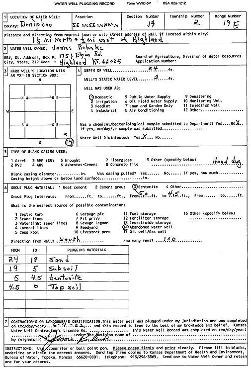
T2S, R19E, Sec. 14 SE SE NW |
Ruhnke, James | 24 ft. | 3 ft. | Domestic | Plugged | 04-Jun-2002 | Scan | ||
|
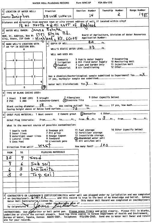
T2S, R19E, Sec. 14 SE SE NW |
Ruhnke, James | 32 ft. | 23 ft. | Domestic, Livestock | Plugged | 04-Jun-2002 | Scan | ||
|
T2S, R19E, Sec. 14 SE SW SE NW |
U.S. Geological Survey | 38 ft. | 33.2 ft. | Monitoring well/observation/piezometer | Constructed | 05-Oct-2010 | |||
|
T2S, R19E, Sec. 16 NE SW NW |
Neibling, Jerry | 45 ft. | 29 ft. | 35 gpm. | Domestic | Constructed | 23-Sep-1975 | ||
|
T2S, R19E, Sec. 18 NE SE NE |
Falk, Vincent | 57 ft. | 32 ft. | 14 gpm. | Domestic | Constructed | 08-Oct-1975 | ||
|
T2S, R19E, Sec. 19 C SE NE |
Gordon, William | 58 ft. | 8 ft. | (unstated)/abandoned | Well 1 | Plugged | 11-Apr-1998 | ||
|
T2S, R19E, Sec. 19 NW SE NE |
Gordon, William | 30 ft. | 5 ft. | (unstated)/abandoned | Well 2 | Plugged | 11-Apr-1998 | ||
|
T2S, R19E, Sec. 19 SW SW NW |
Koelliker, Gilbert | 80 ft. | 54 ft. | 4 gpm. | Domestic | Constructed | 09-Mar-1990 | ||
|
T2S, R19E, Sec. 22 NE SE SE |
Dunn Oil | 25 ft. | 20.88 ft. | Monitoring well/observation/piezometer | MW 8 | Constructed | 17-Sep-2009 | ||
|
T2S, R19E, Sec. 22 NE SE SE |
Dunn Oil | 25 ft. | 20 ft. | Monitoring well/observation/piezometer | MW 3 R | Reconstructed | 15-Feb-2006 | ||
|
T2S, R19E, Sec. 22 NE SE SE |
Dunn Oil | 25 ft. | 22.02 ft. | Monitoring well/observation/piezometer | MW 1 R | Constructed | 17-Sep-2009 | ||
|
T2S, R19E, Sec. 22 NE SE SE |
Dunn Oil | 25 ft. | 20.44 ft. | Monitoring well/observation/piezometer | MW 2 | Constructed | 11-Dec-1997 | ||
|
T2S, R19E, Sec. 22 NE SE SE |
Dunn Oil | 25 ft. | 14.6 ft. | Monitoring well/observation/piezometer | MW 3 | Constructed | 11-Dec-1997 | ||
|
T2S, R19E, Sec. 22 NE SE SE |
Gilmore, Larry | 46.5 ft. | 35 ft. | Monitoring well/observation/piezometer | MW 2 | Constructed | 07-Dec-1990 | ||
|
T2S, R19E, Sec. 22 NE SE SE |
Gilmore, Larry | 49.5 ft. | 32.2 ft. | Monitoring well/observation/piezometer | Plugged | 05-Feb-1993 | |||
|
T2S, R19E, Sec. 22 NE SE SE |
Gilmore, Larry | 49.5 ft. | 32.8 ft. | Monitoring well/observation/piezometer | MW 3 | Constructed | 10-Dec-1990 | ||
|
T2S, R19E, Sec. 22 NE SE SE |
Gilmore, Larry | 49.5 ft. | 32.2 ft. | Monitoring well/observation/piezometer | Constructed | 11-Dec-1990 | |||
|
T2S, R19E, Sec. 22 NE SE SE |
Gilmore, Larry | 46 ft. | 34.1 ft. | Monitoring well/observation/piezometer | MW 1 | Constructed | 06-Dec-1990 | ||
|
T2S, R19E, Sec. 22 SW NE SW SE |
Parker, Mary Ann | 192 ft. | Geothermal, Closed Loop, Horizontal | Constructed | 21-Dec-2012 |
KOLAR |
|||
|
T2S, R19E, Sec. 22 SW NE SE SE |
Pierce Heating and Cooling | 200 ft. | Geothermal, Closed Loop, Vertical | Constructed | 08-Dec-2017 |
KOLAR |
|||
|
T2S, R19E, Sec. 23 SE NE SE |
Clary, Conrad | 35 ft. | 28 ft. | 11 gpm. | Domestic | Constructed | 25-Sep-1975 | ||
|
T2S, R19E, Sec. 23 NW SW SW |
Dunn Oil | 23 ft. | 17.43 ft. | Monitoring well/observation/piezometer | MW 6 | Constructed | 11-Dec-1997 | ||
|
T2S, R19E, Sec. 23 NW SW SW |
Dunn Oil | 23 ft. | 17.21 ft. | Monitoring well/observation/piezometer | MW 7 | Constructed | 11-Dec-1997 | ||
|
T2S, R19E, Sec. 23 NW SW SW |
Dunn Oil | 25 ft. | 18.75 ft. | Monitoring well/observation/piezometer | MW 5 | Constructed | 11-Dec-1997 | ||
|
T2S, R19E, Sec. 23 NW SW SW |
Dunn Oil | 25 ft. | 18.31 ft. | Monitoring well/observation/piezometer | MW 4 | Constructed | 11-Dec-1997 | ||
|
T2S, R19E, Sec. 23 NW SW SW |
Dunn Oil | 25 ft. | 19.71 ft. | Monitoring well/observation/piezometer | MW 9 | Constructed | 17-Sep-2009 | ||
|
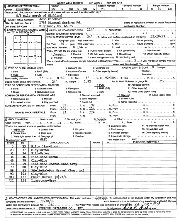
T2S, R19E, Sec. 23 NW NW NW |
Gladhart, John | 114 ft. | 34 ft. | 40 gpm. | Domestic | Constructed | 18-Nov-1999 | Scan | |
|
T2S, R19E, Sec. 24 SW SW SW |
Charles Bell Estate | 100 ft. | 15 ft. | 8 gpm. | Domestic | Constructed | 30-Aug-1996 | ||
|
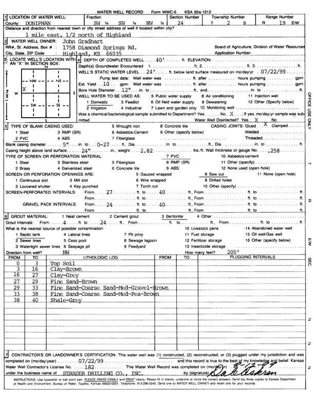
T2S, R19E, Sec. 24 SW SW NW |
Gradhart, John | 40 ft. | 24 ft. | 10 gpm. | Domestic | Constructed | 22-Jul-1999 | Scan | |
|
T2S, R19E, Sec. 24 NE NE SE |
Heinold Hog Market | 130 ft. | 90 ft. | 40 gpm. | Domestic | Constructed | 04-Jun-1980 | ||
|
T2S, R19E, Sec. 24 NW SW NW |
Kluk, Fred | 80 ft. | 18 ft. | 4 gpm. | Domestic | Constructed | 06-Jun-1977 | ||
|
T2S, R19E, Sec. 24 SW SE NE |
Native American Heritage Museum | 65 ft. | 18 ft. | 40 gpm. | Domestic | Constructed | 28-Jul-1997 | ||
|
T2S, R19E, Sec. 24 NE NE SE |
Ruhnke Farms Inc. | 55 ft. | 30 gpm. | Domestic | Constructed | 15-Jun-1976 | |||
|
T2S, R19E, Sec. 24 SW SW SE |
Simpson, Mike | 75 ft. | 44 ft. | 4.5 gpm. | Domestic | Constructed | 26-Dec-1989 | ||
|
T2S, R19E, Sec. 24 SW SE SW SE |
U.S. Geological Survey | 43 ft. | 37.5 ft. | Monitoring well/observation/piezometer | Constructed | 05-Oct-2010 | |||
| View page: 1 || 2 || 3 || 4 || 5 || 6 || 7 || 8 || 9 || 10 || Next > | |||||||||