Select location of well to view details.
Click on column heading to sort.
|
|
|
County: Douglas Select location of well to view details. Click on column heading to sort. |
|
|
|
| View page: < Prev || 11 || 12 || 13 || 14 || 15 || 16 || 17 || 18 || 19 || 20 || Next > | |||||||||
| T-R-S | Owner | Well Depth Ascend. Desc. |
Static Water Level Ascend. Desc. |
Est. Yield Ascend. Desc. |
Well Use | Other ID | Action Taken | Completion Date Ascend. Desc. |
Scan? |
|
T12S, R20E, Sec. 19 SW SE SE SW |
Zeller, Leonard | 25 ft. | Monitoring well/observation/piezometer | AS 4 | Constructed | 24-Nov-2008 | |||
|
T12S, R20E, Sec. 19 SW SE SE SW |
Zeller, Leonard | 25 ft. | Monitoring well/observation/piezometer | AS 2 | Constructed | 24-Nov-2008 | |||
|
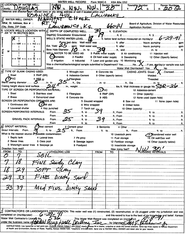
T12S, R20E, Sec. 20 NW NW NW |
Cheek, Margret | 39 ft. | 18 ft. | 25 gpm. | Domestic | Constructed | 29-Jun-1991 | Scan | |
|
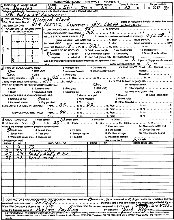
T12S, R20E, Sec. 20 SW SW SW |
Clark, Richard | 42 ft. | 19 ft. | 20 gpm. | Domestic | Constructed | 13-Jul-1987 | Scan | |
|
T12S, R20E, Sec. 20 SE NW SW |
Dalsing, Ethel | 49 ft. | 21 ft. | 100 gpm. | Domestic | Constructed | 30-Jun-2004 | ||
|
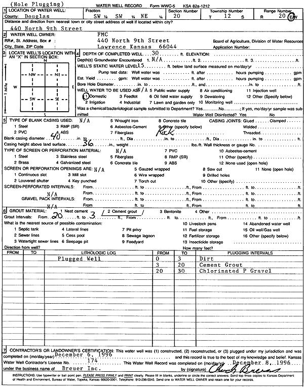
T12S, R20E, Sec. 20 SW SW NE |
FMC | 30 ft. | 15 ft. | Domestic | Plugged | 06-Dec-1996 | Scan | ||
|
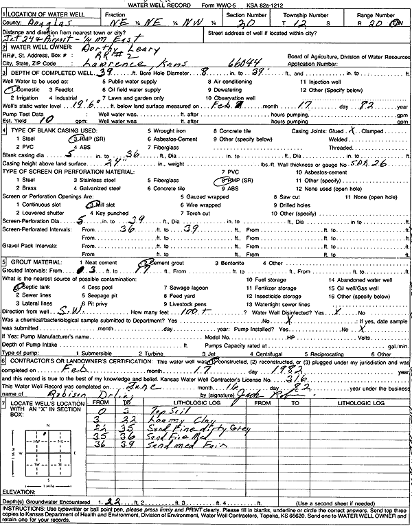
T12S, R20E, Sec. 20 NE NE NW |
Leary, Dorthy | 39 ft. | 19.5 ft. | 10 gpm. | Domestic | Constructed | 17-Feb-1982 | Scan | |
|
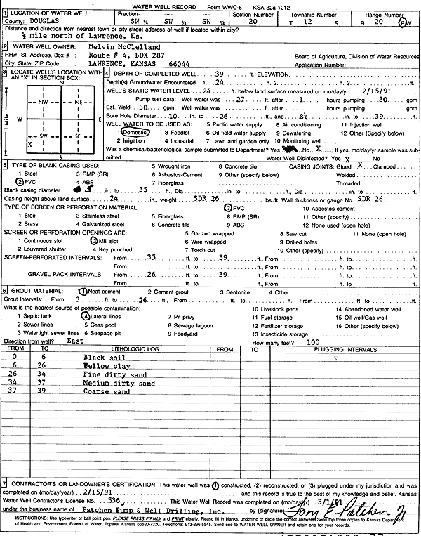
T12S, R20E, Sec. 20 SW SW SW |
McClelland, Melvin | 39 ft. | 24 ft. | 30 gpm. | Domestic | Constructed | 15-Feb-1991 | Scan | |
|
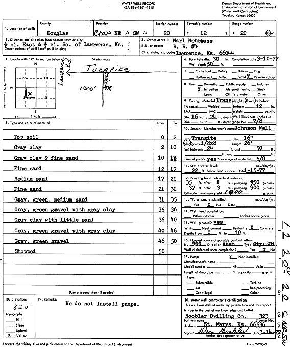
T12S, R20E, Sec. 20 C NE SW |
Nehrbass, Marl | 50 ft. | 22 ft. | 1000 gpm. | Irrigation | Constructed | 10-Mar-1977 | Scan | |
|
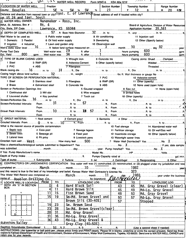
T12S, R20E, Sec. 20 NW SW NE SW |
Nunamaker & Ross, Inc. | 62 ft. | 18 ft. | 250 gpm. | Irrigation | Constructed | 14-Jul-2017 |
KOLAR |
|
|
T12S, R20E, Sec. 20 SW NW SW NW |
Pine Family Farms | 61 ft. | 16 ft. | 500 gpm. | Irrigation | Constructed | 24-May-2017 |
KOLAR |
|
|
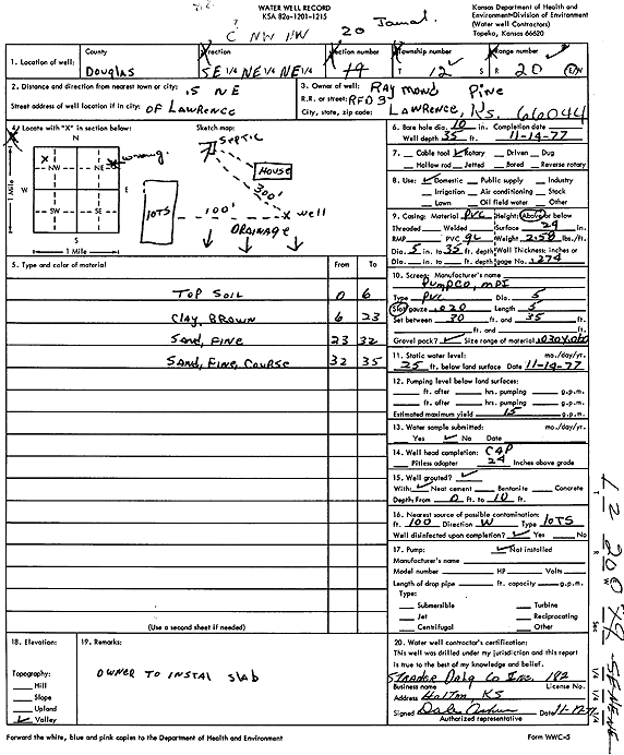
T12S, R20E, Sec. 20 SE NE NE |
Pine, Raymond | 35 ft. | 25 ft. | 15 gpm. | Domestic | Constructed | 14-Nov-1977 | Scan | |
|
T12S, R20E, Sec. 20 SW SW NW |
Pine, Raymond C. | 56 ft. | 23.5 ft. | 1400 gpm. | Irrigation | Constructed | 10-Mar-1977 | Scan | |
|
T12S, R20E, Sec. 20 NW SW SW SW |
Price, Billy | 49 ft. | 23 ft. | 100 gpm. | Domestic | Constructed | 15-Oct-2014 |
KOLAR |
|
|
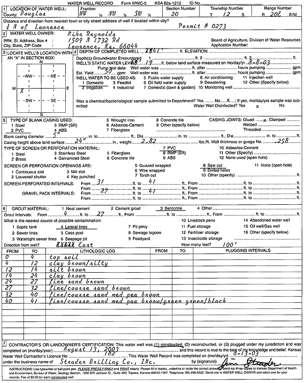
T12S, R20E, Sec. 20 NW NW SW |
Reynolds, Mike | 41 ft. | 19 ft. | 50 gpm. | Domestic | Constructed | 13-Aug-2003 | Scan | |
|
T12S, R20E, Sec. 20 NW SW NE SW |
Ross, Pat | 60 ft. | 16 ft. | 250 gpm. | Irrigation | Constructed | 12-Apr-2018 |
KOLAR |
|
|
T12S, R20E, Sec. 20 NE NE SW |
Ross, Pat and Mary | 57 ft. | 12 ft. | Domestic | Plugged | 25-Jul-2017 | |||
|
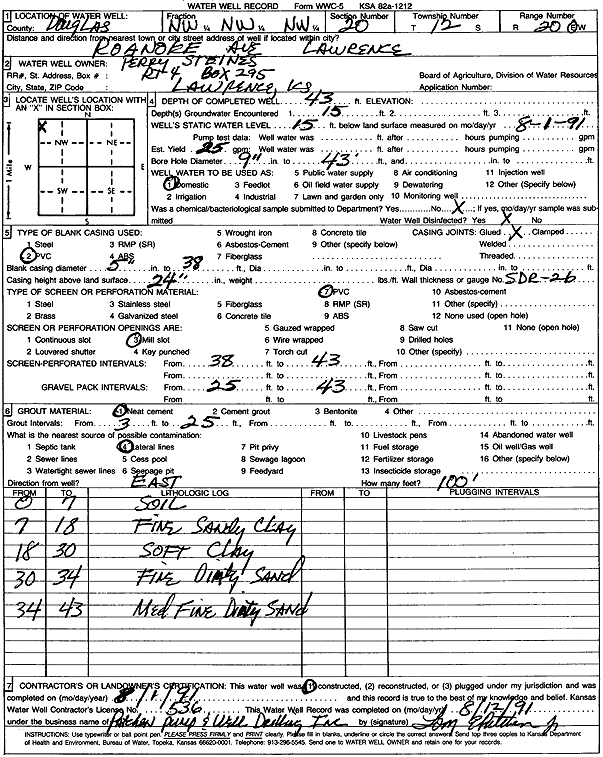
T12S, R20E, Sec. 20 NW NW NW |
Steines, Perry | 43 ft. | 15 ft. | 25 gpm. | Domestic | Constructed | 01-Aug-1991 | Scan | |
|
T12S, R20E, Sec. 20 SW SE SW |
Taylor, Hugh | 50 ft. | 21 ft. | 50 gpm. | Domestic | Constructed | 21-May-1981 | Scan | |
|
T12S, R20E, Sec. 20 SW NW SW |
Thompson, Allen | 39 ft. | 14 ft. | Domestic | Reconstructed | 07-Apr-2020 | |||
|
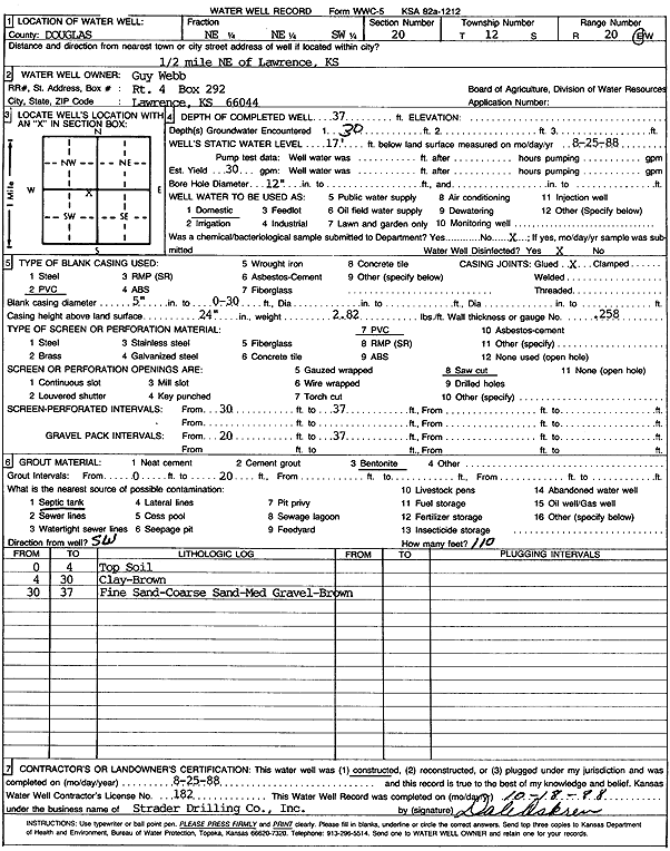
T12S, R20E, Sec. 20 NE NE SW |
Webb, Guy | 37 ft. | 17 ft. | 30 gpm. | Domestic | Constructed | 25-Aug-1988 | Scan | |
|
T12S, R20E, Sec. 20 SW SW SW |
Wright, Thelma | 50 ft. | 20 ft. | 30 gpm. | Domestic | Constructed | 12-Jan-1998 | Scan | |
|
T12S, R20E, Sec. 20 NW NW NE |
50 ft. | 15 ft. | 50 gpm. | Domestic | Constructed | 18-Jun-1981 | |||
|
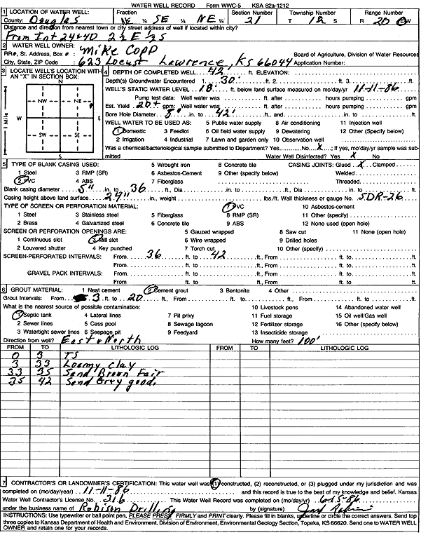
T12S, R20E, Sec. 21 NE SE NE |
Copp, Mike | 42 ft. | 18 ft. | 20 gpm. | Domestic | Constructed | 11-Nov-1986 | Scan | |
|
T12S, R20E, Sec. 21 NE NE NE |
Garcia, Dan | 45 ft. | 21 ft. | 30 gpm. | Domestic | Constructed | 04-Oct-2001 | Scan | |
|
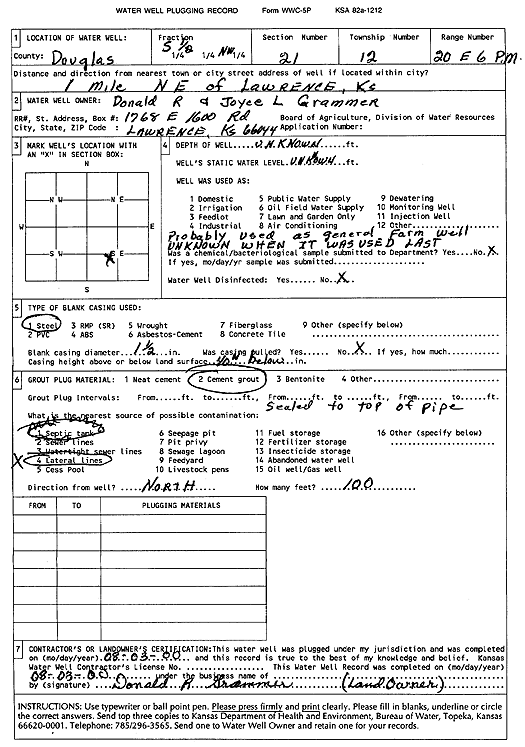
T12S, R20E, Sec. 21 S2 NW |
Grammer, Donald R. and Joyce L. | (unstated)/abandoned | Plugged | 03-Aug-2000 | Scan | ||||
|
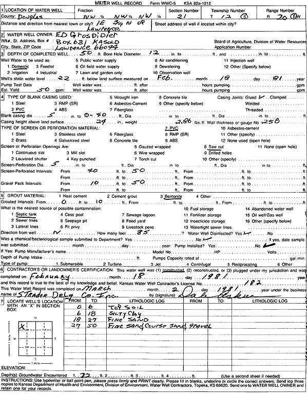
T12S, R20E, Sec. 21 NW NW NW |
Grosdidier, Ed | 50 ft. | 22 ft. | 50 gpm. | Domestic | Constructed | 18-Feb-1981 | Scan | |
|
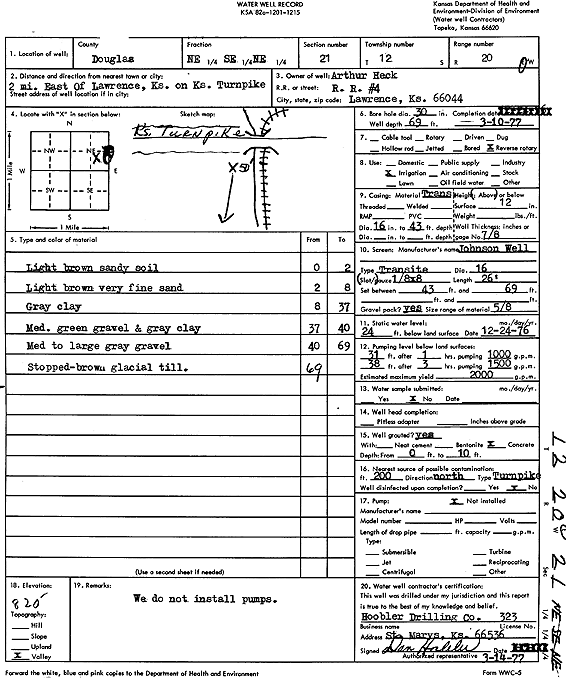
T12S, R20E, Sec. 21 NE SE NE |
Heck, Arthur | 69 ft. | 24 ft. | 2000 gpm. | Irrigation | Constructed | 10-Mar-1977 | Scan | |
|
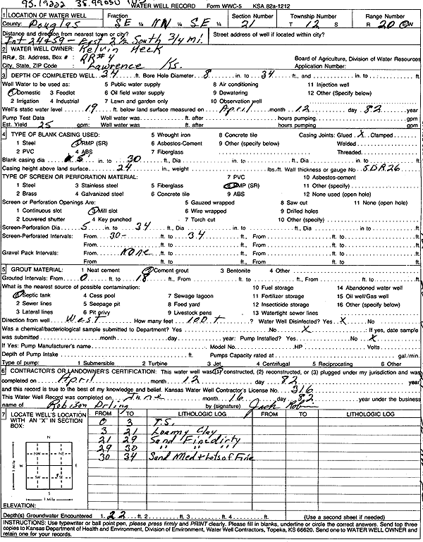
T12S, R20E, Sec. 21 SE NW SE |
Heck, Kelvin | 34 ft. | 19 ft. | 25 gpm. | Domestic | Constructed | 12-Apr-1982 | Scan | |
|
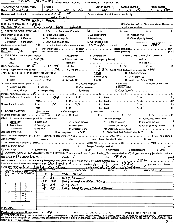
T12S, R20E, Sec. 21 NW NW SE |
Heck, Kelvin | 55 ft. | 26 ft. | 100 gpm. | Domestic | Constructed | 01-Dec-1980 | Scan | |
|
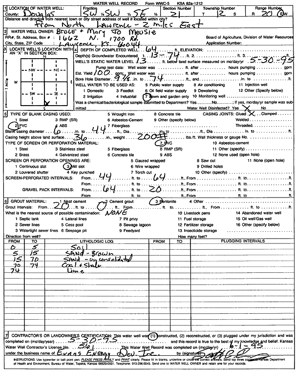
T12S, R20E, Sec. 21 SW SW SE |
Meusie, Bruce and Mary Jo | 64 ft. | 13 ft. | 100 gpm. | Domestic, Lawn and Garden | Constructed | 30-May-1995 | Scan | |
|
T12S, R20E, Sec. 21 SW SE SW SW |
Nunnemaker Ross, Inc. | 43 ft. | 23 ft. | 120 gpm. | Domestic, Lawn and Garden | Constructed | 22-Apr-2015 |
KOLAR |
|
|
T12S, R20E, Sec. 21 SE SW SW |
Nunnemaker Ross, Inc. | 57 ft. | 16 ft. | 800 gpm. | Irrigation | Constructed | 10-Mar-1982 | Scan | |
|
T12S, R20E, Sec. 21 SW SE SW SE |
Ruff, Dave | 63 ft. | 15 ft. | 100 gpm. | Domestic | Constructed | 20-Jun-2017 |
KOLAR |
|
|
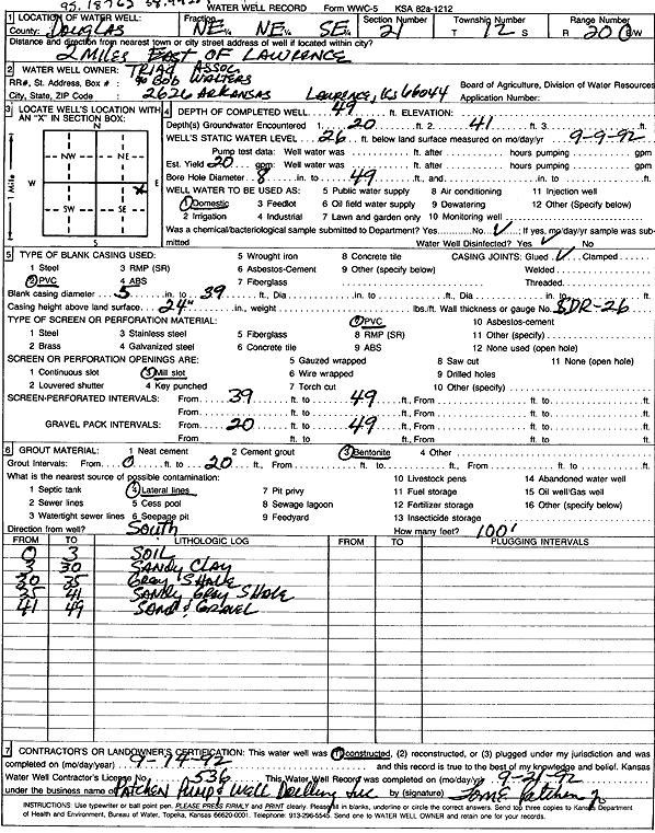
T12S, R20E, Sec. 21 NE NE SE |
Triad Associates | 49 ft. | 26 ft. | 20 gpm. | Domestic | Constructed | 14-Sep-1992 | Scan | |
|
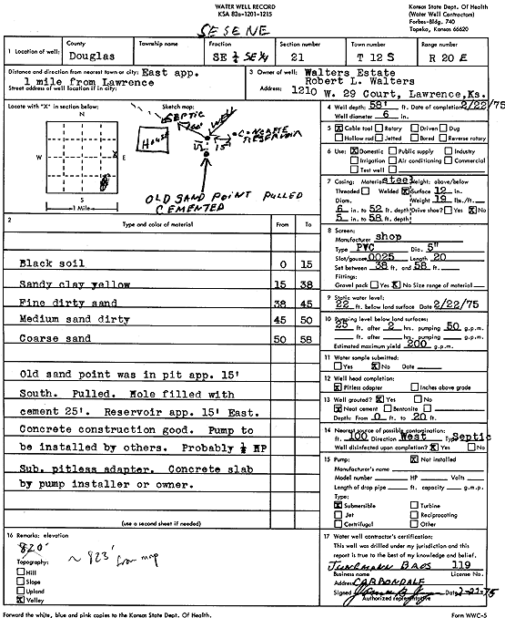
T12S, R20E, Sec. 21 SE SE |
Walters Estate | 58 ft. | 22 ft. | 200 gpm. | Domestic | Constructed | 22-Feb-1975 | Scan | |
|
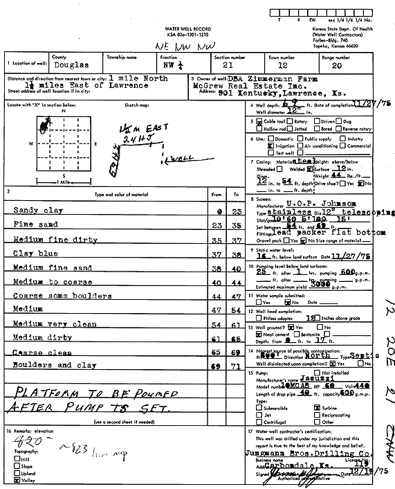
T12S, R20E, Sec. 21 NW |
Zimmerman Farm | 69 ft. | 16 ft. | 3000 gpm. | Irrigation | Constructed | 27-Nov-1975 | Scan | |
|
T12S, R20E, Sec. 25 NE NE NE |
Tunget, Sharla | 132 ft. | 36 ft. | 2.7 gpm. | Domestic | Constructed | 13-Sep-2024 |
KOLAR |
|
|
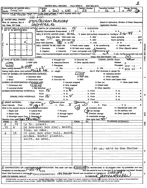
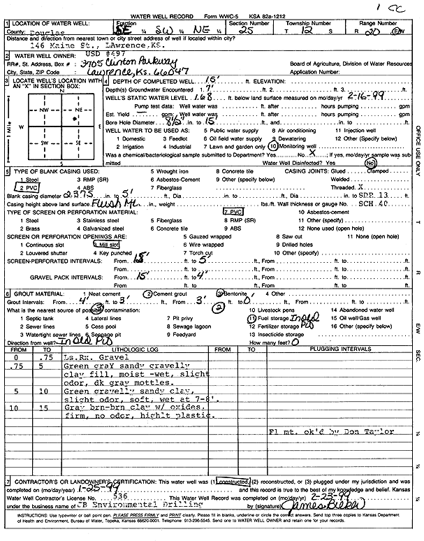
T12S, R20E, Sec. 25 SE SW NE |
USD 497 | 15 ft. | 12.42 ft. | Monitoring well/observation/piezometer | MW 5 | Constructed | 25-Jan-1999 | Scan | |
|
T12S, R20E, Sec. 25 SE SW NE |
USD 497 | 15 ft. | Monitoring well/observation/piezometer | MW 3 | Constructed | 25-Jan-1999 | Scan | ||
|
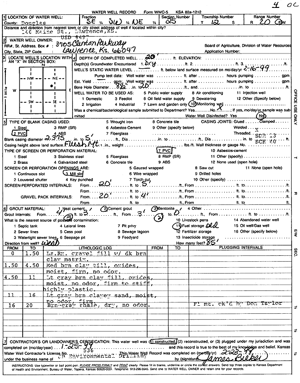
T12S, R20E, Sec. 25 SE SW NE |
USD 497 | 20 ft. | Monitoring well/observation/piezometer | MW 4 | Constructed | 25-Jan-1999 | Scan | ||
|
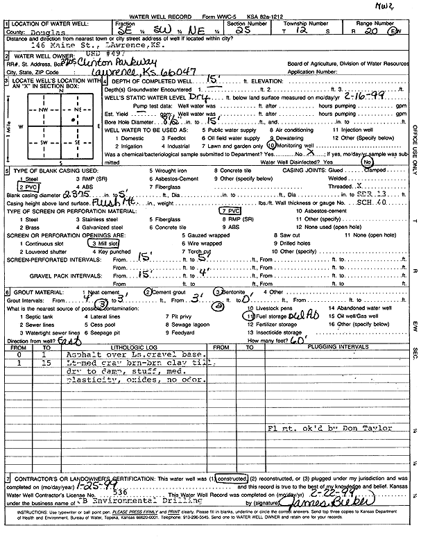
T12S, R20E, Sec. 25 SE SW NE |
USD 497 | 15 ft. | Monitoring well/observation/piezometer | MW 2 | Constructed | 25-Jan-1999 | Scan | ||
|
T12S, R20E, Sec. 25 SE SW NE |
USD 497 | 15 ft. | 1.68 ft. | Monitoring well/observation/piezometer | MW 1 | Constructed | 25-Jan-1999 | Scan | |
|
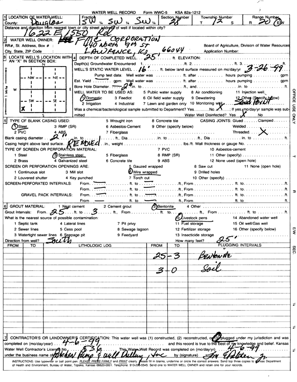
T12S, R20E, Sec. 28 SW SW SW |
FMC Corporation | 25 ft. | 16 ft. | Domestic | Plugged | 06-Apr-1999 | Scan | ||
|
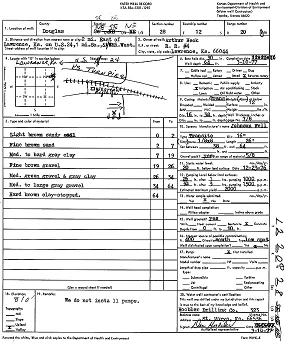
T12S, R20E, Sec. 28 SE NE NE |
Heck, Arthur | 64 ft. | 20 ft. | 2000 gpm. | Irrigation | Constructed | 10-Mar-1977 | Scan | |
|
T12S, R20E, Sec. 28 NE NW SE |
Irene S Vogel Trustee | 55 ft. | 10 ft. | Irrigation | Constructed | 25-Feb-2009 | |||
|
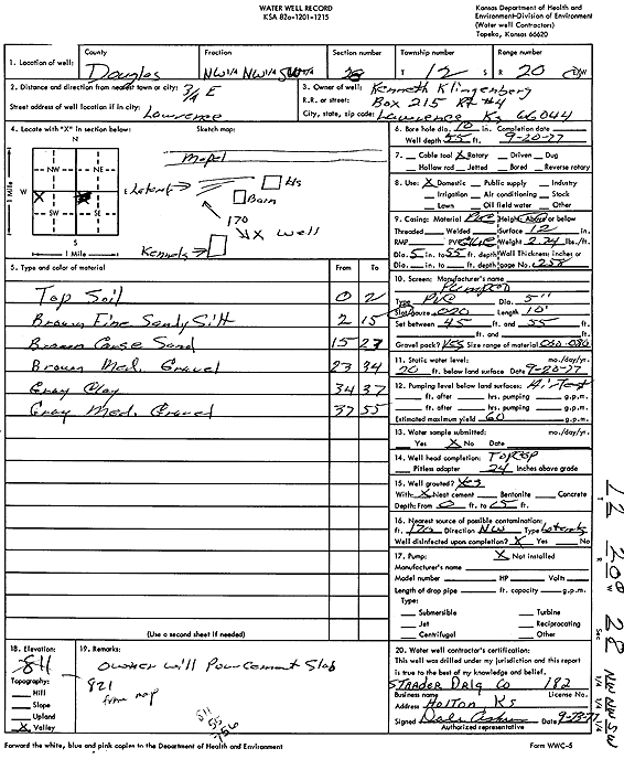
T12S, R20E, Sec. 28 NW NW SW |
Klingenberg, Kenneth | 55 ft. | 20 ft. | 60 gpm. | Domestic | Constructed | 20-Sep-1977 | Scan | |
|
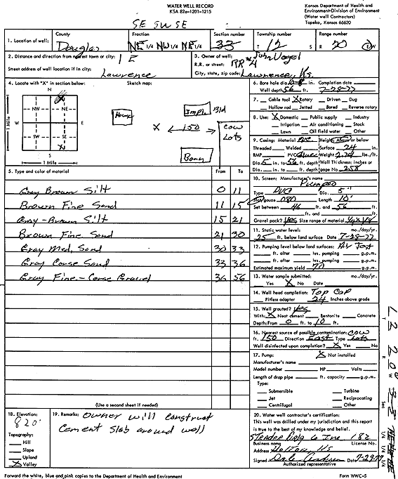
T12S, R20E, Sec. 28 NE NW NE |
Vogel, John | 56 ft. | 25 ft. | 70 gpm. | Domestic | Constructed | 28-Jul-1977 | Scan | |
|
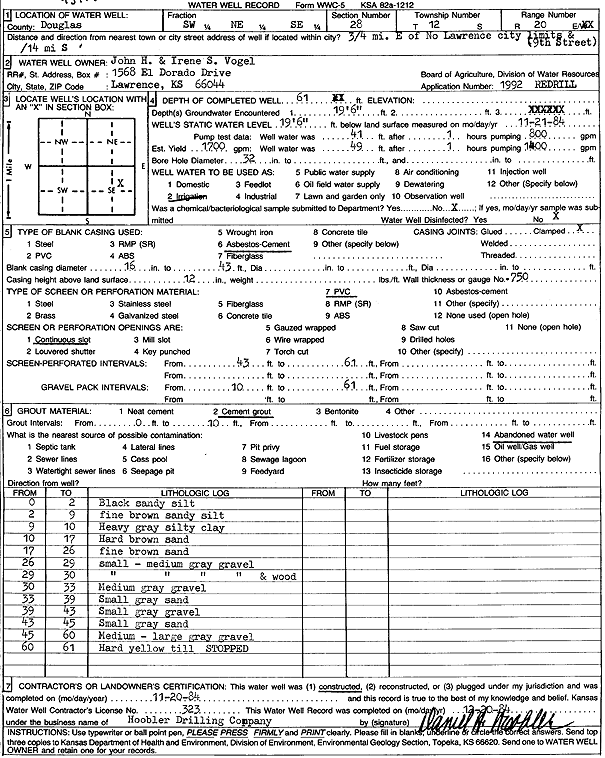
T12S, R20E, Sec. 28 SW NE SE |
Vogel, John H. and Irene S. | 61 ft. | 19.5 ft. | 1700 gpm. | Irrigation | Constructed | 20-Nov-1984 | Scan | |
|
T12S, R20E, Sec. 28 NW SW |
Wang, Edward | 9 ft. | Domestic | Plugged | 21-May-2009 | ||||
| View page: < Prev || 11 || 12 || 13 || 14 || 15 || 16 || 17 || 18 || 19 || 20 || Next > | |||||||||