Select location of well to view details.
Click on column heading to sort.
|
|
|
County: Douglas Select location of well to view details. Click on column heading to sort. |
|
|
|
| View page: < Prev || 21 || 22 || 23 || 24 || 25 || 26 || 27 || 28 || 29 || 30 || Next > | |||||||||
| T-R-S | Owner | Well Depth Ascend. Desc. |
Static Water Level Ascend. Desc. |
Est. Yield Ascend. Desc. |
Well Use | Other ID | Action Taken | Completion Date Ascend. Desc. |
Scan? |
|
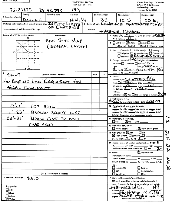
T12S, R20E, Sec. 32 NW |
Lawrence Wastewater Plant | 31 ft. | 25.33 ft. | Monitoring well/observation/piezometer | SW 7 | Constructed | 18-Oct-1976 | Scan | |
|
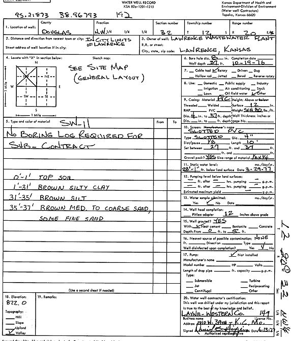
T12S, R20E, Sec. 32 NW |
Lawrence Wastewater Plant | 37 ft. | 28.08 ft. | Monitoring well/observation/piezometer | SW 11 | Constructed | 19-Oct-1976 | Scan | |
|
T12S, R20E, Sec. 32 SE SE SW |
Pratte, Cameron | 340 ft. | Geothermal, Closed Loop, Vertical | Constructed | 14-Apr-2023 |
KOLAR |
|||
|
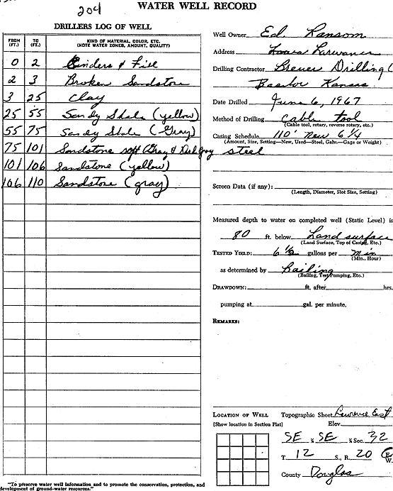
T12S, R20E, Sec. 32 SE SE |
Ransom, Ed. | 110 ft. | 80 ft. | 6.5 gpm. | Domestic | Constructed | 06-Jun-1967 | Scan | |
|
T12S, R20E, Sec. 32 SE SE NE |
Schaake, Dorthy | 69 ft. | 3 ft. | Domestic | Plugged | 24-Jun-2006 | |||
|
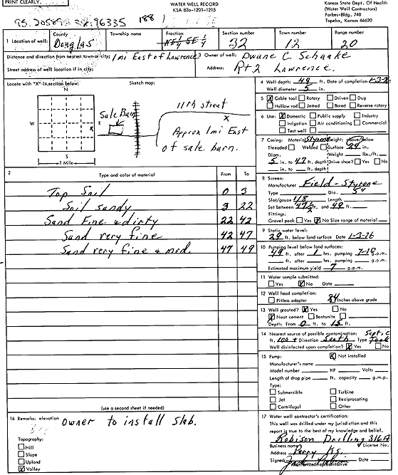
T12S, R20E, Sec. 32 NE NE SE |
Schaake, Dwane C. | 49 ft. | 29 ft. | 7 gpm. | Domestic | Constructed | 03-Jan-1976 | Scan | |
|
T12S, R20E, Sec. 32 SE NW SW |
Shaheen, Latif/Gabbert, Seth | 334 ft. | 10 ft. | 30 gpm. | Geothermal, Closed Loop, Vertical | Constructed | 17-Mar-2023 |
KOLAR |
|
|
T12S, R20E, Sec. 33 NE SW SW SE |
Bloom, Eric | 180 ft. | Geothermal, Closed Loop, Vertical | Constructed | 17-Jan-2019 |
KOLAR |
|||
|
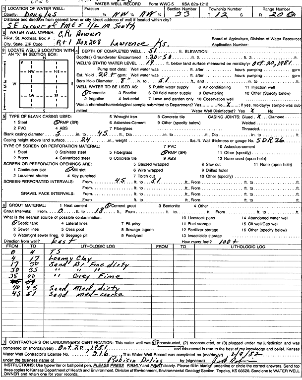
T12S, R20E, Sec. 33 NW NW |
Bowen, C.R. | 51 ft. | 19 ft. | 20 gpm. | Domestic | Constructed | 20-Oct-1981 | Scan | |
|
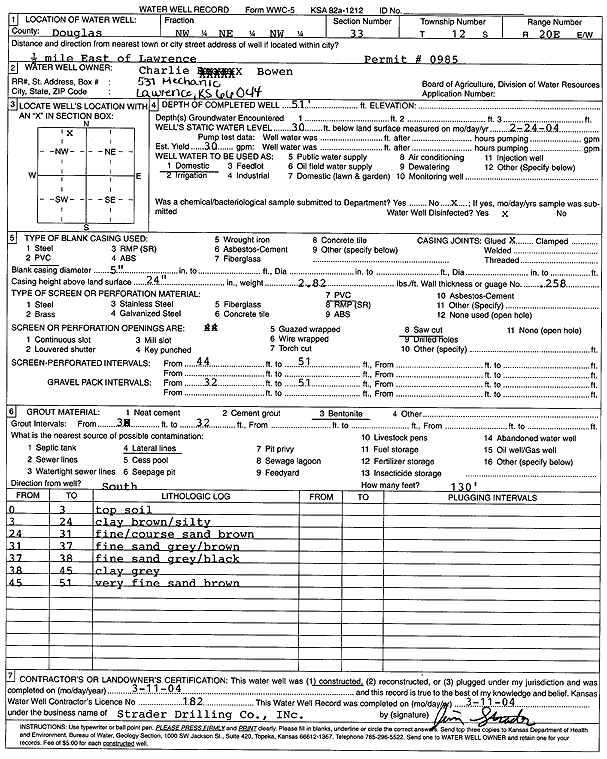
T12S, R20E, Sec. 33 NW NE NW |
Bowen, Charlie | 51 ft. | 30 ft. | 30 gpm. | Domestic | Constructed | 11-Mar-2004 | Scan | |
|
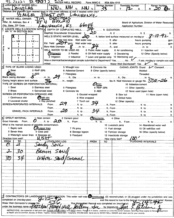
T12S, R20E, Sec. 33 NW NW NW |
Brothers, Jim | 34 ft. | 20 ft. | 20 gpm. | Domestic | Constructed | 12-Aug-1992 | Scan | |
|
T12S, R20E, Sec. 33 SW SW SW SW |
City of Lawrence | 52 ft. | 27.5 ft. | Monitoring well/observation/piezometer | PSW 208 | Constructed | 20-Mar-2013 | ||
|
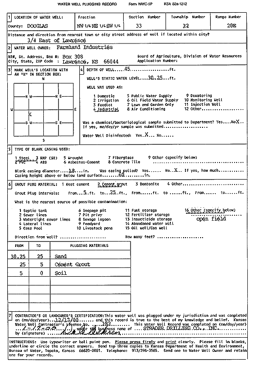
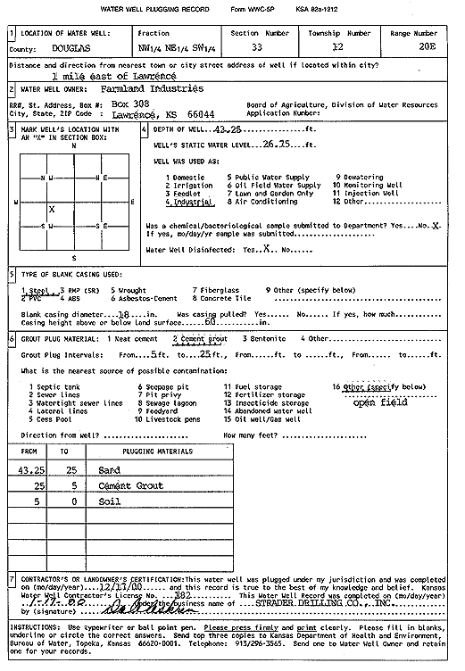
T12S, R20E, Sec. 33 NW NE SW |
Farmland Industries Inc. | 45 ft. | 30.25 ft. | Industrial | Plugged | 17-Dec-1999 | Scan | ||
|
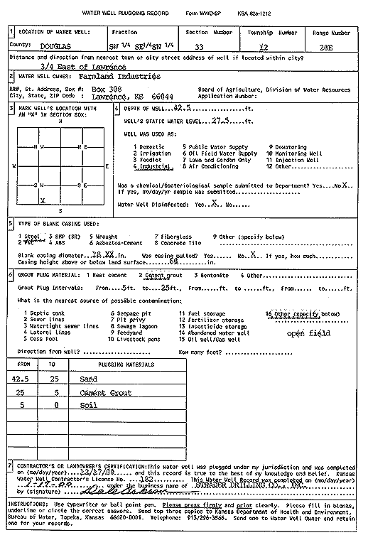
T12S, R20E, Sec. 33 SW SE SW |
Farmland Industries Inc. | 42.5 ft. | 27.5 ft. | Industrial | Plugged | 17-Dec-1999 | Scan | ||
|
T12S, R20E, Sec. 33 NW NE SW |
Farmland Industries Inc. | 43.25 ft. | 26.75 ft. | Industrial | Plugged | 17-Dec-1999 | Scan | ||
|
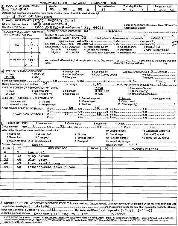
T12S, R20E, Sec. 33 SW SW SE |
Frank Kennedy Trust | 58 ft. | 32 ft. | 70 gpm. | Domestic | Constructed | 01-Apr-2004 | Scan | |
|
T12S, R20E, Sec. 33 SE SW SE |
Kennedy Estate | 60 ft. | 30 ft. | Domestic | Plugged | 30-Mar-2004 | Scan | ||
|
T12S, R20E, Sec. 33 NW NE NW NW |
Lafrez, Cliff | 48 ft. | 28 ft. | 15 gpm. | Domestic | Constructed | 07-Sep-2017 |
KOLAR |
|
|
T12S, R20E, Sec. 33 SE SW SE |
Natale, Sam | 40 ft. | 25 ft. | Domestic | Plugged | 17-Aug-2023 | |||
|
T12S, R20E, Sec. 33 SE SW SE |
Natale, Samuel | 61 ft. | 36 ft. | 30 gpm. | Domestic | Constructed | 16-Aug-2023 |
KOLAR |
|
|
T12S, R20E, Sec. 33 SW NW SE |
Public Wholesale Water Dist. 25 | 53 ft. | 33 ft. | Domestic | B 1 | Constructed | 09-May-2018 | ||
|
T12S, R20E, Sec. 33 NW SE NW SE |
Public Wholesale Water Dist. 25 | 53.5 ft. | 33 ft. | Industrial | B 1 | Constructed | 09-May-2018 | ||
|
T12S, R20E, Sec. 33 SE NW SE |
PWWSD 25 | 54 ft. | 25.45 ft. | Test hole/well | TW 1-09 | Constructed | 21-Jan-2009 | ||
|
T12S, R20E, Sec. 33 NE NW SE |
PWWSD 25 | 59 ft. | 25.95 ft. | Monitoring well/observation/piezometer | Plugged | 15-May-2009 | |||
|
T12S, R20E, Sec. 33 SW NW SE |
PWWSD 25 | 53.5 ft. | Public Water Supply | Constructed | 28-Jun-2017 | ||||
|
T12S, R20E, Sec. 33 SW NW SE |
PWWSD 25 | 56 ft. | 25.45 ft. | Monitoring well/observation/piezometer | Plugged | 15-May-2009 | |||
|
T12S, R20E, Sec. 33 SE NW SE |
PWWSD 25 | 57 ft. | 25.45 ft. | Monitoring well/observation/piezometer | Plugged | 15-May-2009 | |||
|
T12S, R20E, Sec. 33 SW NE NW SE |
Terracon | 51 ft. | 30 ft. | 80 gpm. | Monitoring well/observation/piezometer | Constructed | 07-Mar-2018 |
KOLAR |
|
|
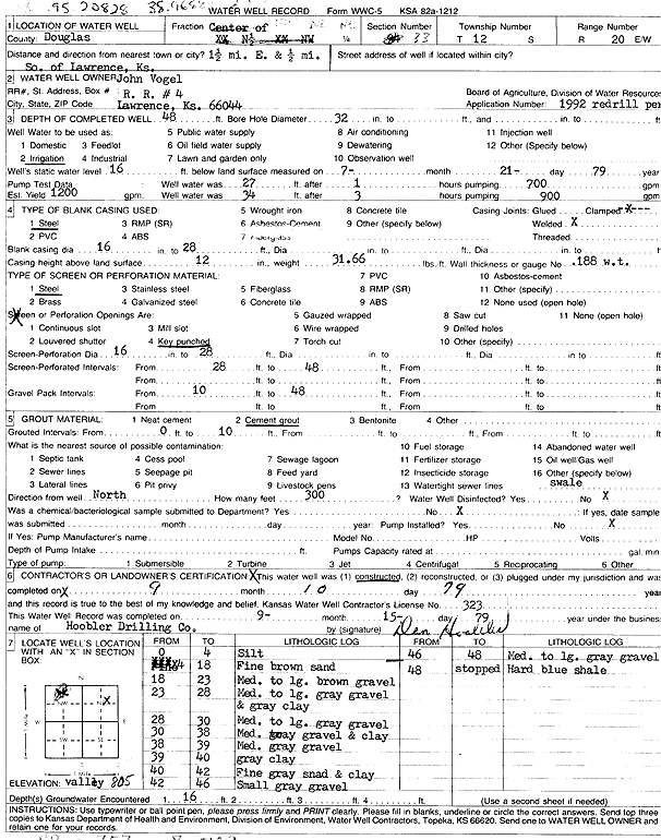
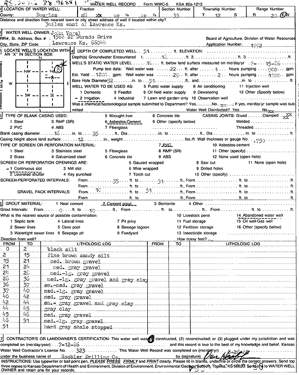
T12S, R20E, Sec. 33 SW NE NE |
Vogel, John | 48 ft. | 16 ft. | 1200 gpm. | Irrigation | Constructed | 10-Sep-1979 | Scan | |
|
T12S, R20E, Sec. 33 S2 NE NE |
Vogel, John | 51 ft. | 18 ft. | 1200 gpm. | Irrigation | Constructed | 12-Jul-1986 | Scan | |
|
T12S, R20E, Sec. 34 SE SE NW SE |
Public Wholesale Water Dist. 25 | 53.5 ft. | 29 ft. | Domestic | B 4 | Constructed | 10-May-2018 | ||
|
T12S, R20E, Sec. 34 SE |
Public Wholesale Water Dist. 25 | 55 ft. | 29 ft. | Domestic | B 3 | Constructed | 08-May-2018 | ||
|
T12S, R20E, Sec. 34 SW NW SE |
Public Wholesale Water Dist. 25 | 53 ft. | 32 ft. | Domestic | B 2 | Constructed | 10-May-2018 | ||
|
T12S, R20E, Sec. 34 NE SE NE SW |
Public Wholesale Water Dist. 25 | 53.5 ft. | 32 ft. | Industrial | B 2 | Constructed | 10-May-2018 | ||
|
T12S, R20E, Sec. 34 SE NW SE |
Public Wholesale Water Dist. 25 | 55.2 ft. | 29.5 ft. | Industrial | B 3 | Constructed | 08-May-2018 | ||
|
T12S, R20E, Sec. 34 SE NW SW |
Public Wholesale Water Supply District No. 25 | 56 ft. | 24.33 ft. | Test hole/well | TW 9-09 | Constructed | 01-Oct-2009 | ||
|
T12S, R20E, Sec. 34 SW NE SW |
Public Wholesale Water Supply District No. 25 | 56 ft. | 27.6 ft. | Test hole/well | TW 8-09 | Constructed | 30-Sep-2009 | ||
|
T12S, R20E, Sec. 34 SE SW SE |
PWWSD 25 | 56 ft. | 27.64 ft. | Monitoring well/observation/piezometer | TH 6-09 A | Plugged | 09-Dec-2010 | ||
|
T12S, R20E, Sec. 34 SW SE SE |
PWWSD 25 | 57 ft. | 24.7 ft. | Monitoring well/observation/piezometer | TH 5-09 | Plugged | 09-Dec-2010 | ||
|
T12S, R20E, Sec. 34 SE SE SE |
PWWSD 25 | 55 ft. | 27.78 ft. | Monitoring well/observation/piezometer | TH 7-09 | Plugged | 09-Dec-2010 | ||
|
T12S, R20E, Sec. 34 SE SW SE |
PWWSD 25 | 57 ft. | 24.09 ft. | Monitoring well/observation/piezometer | TH 4-09 | Plugged | 09-Dec-2010 | ||
|
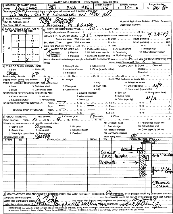
T12S, R20E, Sec. 34 SW SW SE |
Schmidt, Edna | 50 ft. | 25 ft. | Domestic | Reconstructed | 29-Sep-1997 | Scan | ||
|
T12S, R20E, Sec. 34 SW SW |
Schwarting, Nancy | 27 ft. | Domestic | Plugged | 04-Aug-2014 | ||||
|
T12S, R20E, Sec. 34 SW SW |
Schwarting, Nancy | 55 ft. | 32.45 ft. | 30 gpm. | Domestic | Constructed | 04-Aug-2014 | ||
|
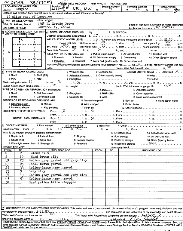
T12S, R20E, Sec. 34 NW NE NW |
Vogel, John | 54 ft. | 17 ft. | 1000 gpm. | Irrigation | Constructed | 11-Feb-1987 | Scan | |
|
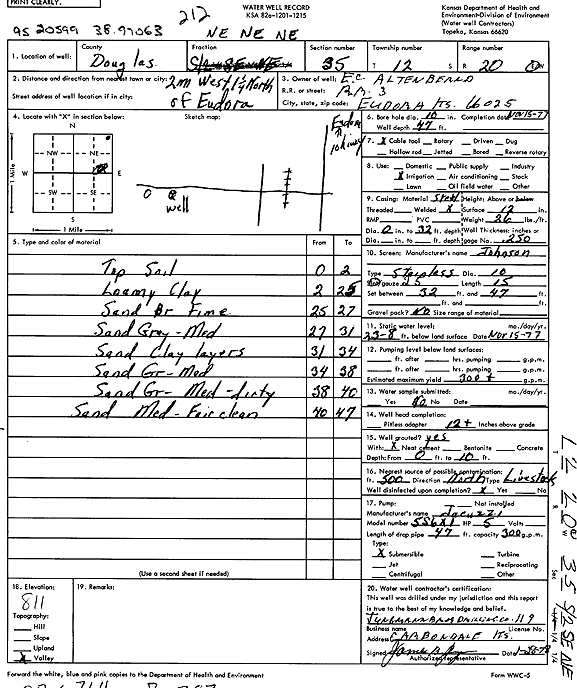
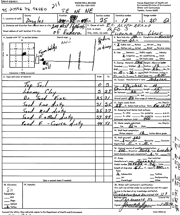
T12S, R20E, Sec. 35 NE NE NE |
Altenbernd, E. C. | 47 ft. | 23.8 ft. | 300 gpm. | Irrigation | Constructed | 15-Nov-1977 | Scan | |
|
T12S, R20E, Sec. 35 SE NE NE |
Altenbernd, E. C. | 51 ft. | 28 ft. | 400 gpm. | Irrigation | Constructed | 15-Nov-1977 | Scan | |
|
T12S, R20E, Sec. 35 SE NE NE |
Altenbernd, E. C. | 51 ft. | 12 ft. | 100 gpm. | Domestic | Constructed | 25-Aug-1977 | Scan | |
|
T12S, R20E, Sec. 35 NW NW SW SW |
City of Lawrence | 80.6 ft. | 33 ft. | Public Water Supply | Plugged | 10-Dec-2014 | |||
|
T12S, R20E, Sec. 35 SW SE SW SW |
City of Lawrence | 72 ft. | 27.6 ft. | Public Water Supply | Plugged | 10-Dec-2014 | |||
| View page: < Prev || 21 || 22 || 23 || 24 || 25 || 26 || 27 || 28 || 29 || 30 || Next > | |||||||||