Select location of well to view details.
Click on column heading to sort.
|
|
|
County: Douglas Select location of well to view details. Click on column heading to sort. |
|
|
|
| View page: 1 || 2 || 3 || 4 || 5 || 6 || 7 || 8 || 9 || 10 || Next > | |||||||||
| T-R-S | Owner | Well Depth Ascend. Desc. |
Static Water Level Ascend. Desc. |
Est. Yield Ascend. Desc. |
Well Use | Other ID | Action Taken | Completion Date Ascend. Desc. |
Scan? |
|
T12S, R19E, Sec. 11 NE NW NE |
Haley, Gene/Haley Farms | 77 ft. | 22 ft. | 1200 gpm. | Irrigation | Constructed | 05-Dec-2002 | ||
|
T12S, R19E, Sec. 12 SE SE NE |
Heck, Emil Jr. | 45 ft. | 23 ft. | 50 gpm. | Domestic | Constructed | 03-Jul-1979 | ||
|
T12S, R19E, Sec. 12 NW NW SW |
Husted, Clyde | 46 ft. | 20 ft. | Domestic | Plugged | 09-Dec-1996 | |||
|
T12S, R19E, Sec. 12 NW NW SW |
Husted, Clyde | 63 ft. | 22 ft. | 30 gpm. | Domestic | Constructed | 06-Dec-1996 | ||
|
T12S, R19E, Sec. 12 NW SW NW |
Husted, Clyde | 34 ft. | 10 ft. | 20 gpm. | Domestic | Constructed | 23-Apr-1991 | ||
|
T12S, R19E, Sec. 12 NW NE NW |
Strong, Dan | 70 ft. | 25 ft. | Irrigation | Constructed | 03-Feb-2015 | |||
|
T12S, R19E, Sec. 13 SW NE SW SW |
Evergy Kansas Central, Inc. (f.k.a. Westar) | 38.55 ft. | 33.8 ft. | Monitoring well/observation/piezometer | Plugged | 09-Dec-2020 |
KOLAR |
||
|
T12S, R19E, Sec. 13 NE NE NE |
Husted, Clyde | 31 ft. | 20 gpm. | Domestic | Constructed | 30-Dec-1992 | |||
|
T12S, R19E, Sec. 13 NE NE NE |
Husted, Clyde | 20 ft. | Domestic | Constructed | 16-Sep-1989 | ||||
|
T12S, R19E, Sec. 13 SE NW NW |
Pines International, Inc. | 45 ft. | 12 ft. | 120 gpm. | Irrigation | Constructed | 21-Aug-1990 | ||
|
T12S, R19E, Sec. 13 SW NE SW |
Westar Energy | 23 ft. | Monitoring well/observation/piezometer | MW 25 | Constructed | 13-Nov-2007 | |||
|
T12S, R19E, Sec. 13 NE SW SW |
Westar Energy | 20 ft. | 19 ft. | Monitoring well/observation/piezometer | MW 22 | Plugged | 04-Oct-2007 | ||
|
T12S, R19E, Sec. 13 SW NE SW |
Westar Energy | 24.2 ft. | 21.95 ft. | Domestic | Plugged | 15-Dec-2010 | |||
|
T12S, R19E, Sec. 13 NE SW SW |
Westar Energy | 71 ft. | 65 ft. | Monitoring well/observation/piezometer | P 20 | Plugged | 04-Oct-2007 | ||
|
T12S, R19E, Sec. 13 NE SW SW |
Westar Energy | 47 ft. | 25 ft. | Monitoring well/observation/piezometer | P 21 | Plugged | 04-Oct-2007 | ||
|
T12S, R19E, Sec. 13 SW NE SW |
Westar Energy | 25 ft. | Monitoring well/observation/piezometer | MW 28 | Constructed | 14-Nov-2007 | |||
|
T12S, R19E, Sec. 13 SW NE SW |
Westar Energy | 20.5 ft. | Monitoring well/observation/piezometer | MW 27 | Constructed | 13-Nov-2007 | |||
|
T12S, R19E, Sec. 13 SW NE SW |
Westar Energy | 16 ft. | Monitoring well/observation/piezometer | MW 26 | Constructed | 12-Nov-2007 | |||
|
T12S, R19E, Sec. 14 NE NW NW |
Evergy Kansas Central, Inc | 48 ft. | Monitoring well/observation/piezometer | MW 113 | Constructed | 17-Jun-2021 | |||
|
T12S, R19E, Sec. 14 SW NW NW |
Evergy Kansas Central, Inc | 49 ft. | Monitoring well/observation/piezometer | MW 107 | Constructed | 17-Jun-2021 | |||
|
T12S, R19E, Sec. 14 NW SW NW |
Evergy Kansas Central, Inc | 47 ft. | Monitoring well/observation/piezometer | MW 108 | Constructed | 17-Jun-2021 | |||
|
T12S, R19E, Sec. 14 SW NE NW |
Evergy Kansas Central, Inc | 48 ft. | Monitoring well/observation/piezometer | MW 109 | Constructed | 17-Jun-2021 | |||
|
T12S, R19E, Sec. 14 NW NE NW |
Evergy Kansas Central, Inc | 48 ft. | Monitoring well/observation/piezometer | MW 110 | Constructed | 17-Jun-2021 | |||
|
T12S, R19E, Sec. 14 NW SW NENW |
Evergy Services Inc | 49 ft. | 14.91 ft. | Monitoring well/observation/piezometer | MW 103 | Constructed | 21-Jan-2021 | ||
|
T12S, R19E, Sec. 14 NE NE SE NW |
Evergy Services Inc | 46 ft. | 10.45 ft. | Monitoring well/observation/piezometer | MW 104 | Constructed | 21-Jan-2021 | ||
|
T12S, R19E, Sec. 14 NW SW NW NW |
Evergy Services Inc | 47 ft. | 13.37 ft. | Monitoring well/observation/piezometer | MW 101 | Constructed | 21-Jan-2021 | ||
|
T12S, R19E, Sec. 14 NE NE SW NW |
Evergy Services Inc | 158 ft. | Monitoring well/observation/piezometer | MW 105 | Plugged | 16-Jan-2021 | |||
|
T12S, R19E, Sec. 14 SW SW SW SW |
Evergy Services Inc | 50 ft. | 37.5 ft. | Monitoring well/observation/piezometer | MW 106 | Constructed | 21-Jan-2021 | ||
|
T12S, R19E, Sec. 14 NW SW NW NW |
Evergy Services Inc | 49 ft. | 14.63 ft. | Monitoring well/observation/piezometer | MW 102 | Constructed | 21-Jan-2021 | ||
|
T12S, R19E, Sec. 14 SE SE SE |
Johnson, Roger | 180 ft. | 90 ft. | Domestic | Plugged | 06-May-2010 | |||
|
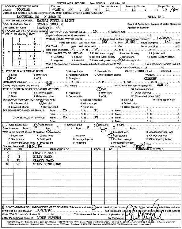
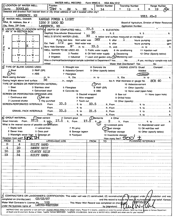
T12S, R19E, Sec. 14 SE NW SE |
Kansas Power and Light | 25 ft. | 1 gpm. | Monitoring well/observation/piezometer | MW B1 | Constructed | 03-Mar-1997 | Scan | |
|
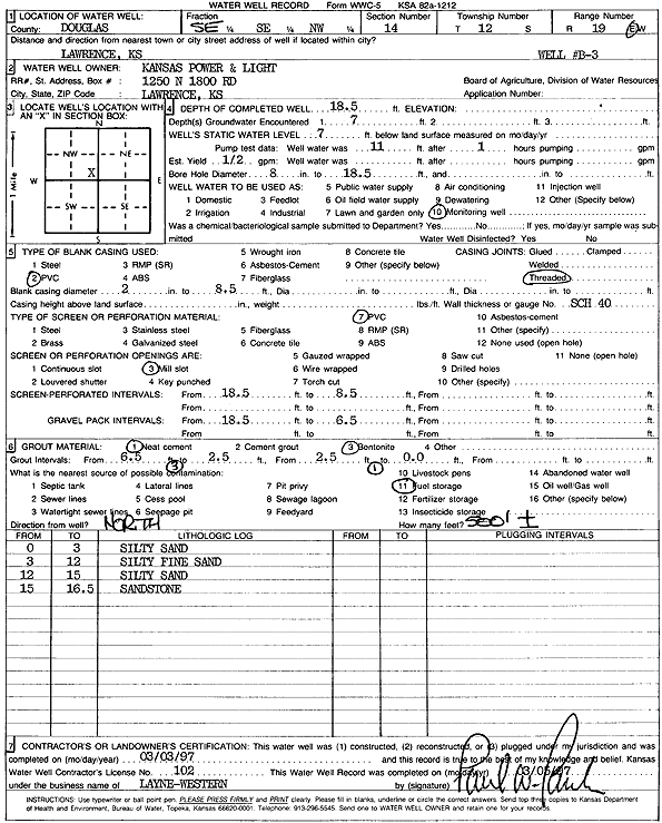
T12S, R19E, Sec. 14 SE SE NW |
Kansas Power and Light | 18.5 ft. | 7 ft. | .5 gpm. | Monitoring well/observation/piezometer | MW B3 | Constructed | 03-Mar-1997 | Scan |
|
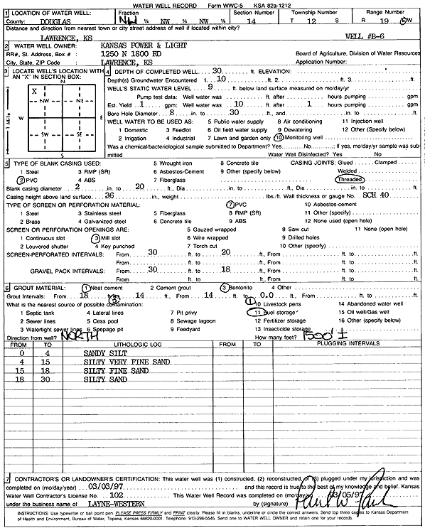
T12S, R19E, Sec. 14 NW NW NW |
Kansas Power and Light | 30 ft. | 9 ft. | 1 gpm. | Monitoring well/observation/piezometer | Well B6 | Constructed | 03-Mar-1997 | Scan |
|
T12S, R19E, Sec. 14 NE NE SE |
Kansas Power and Light | 35.3 ft. | 26 ft. | Other | Constructed | 03-Sep-1979 | Scan | ||
|
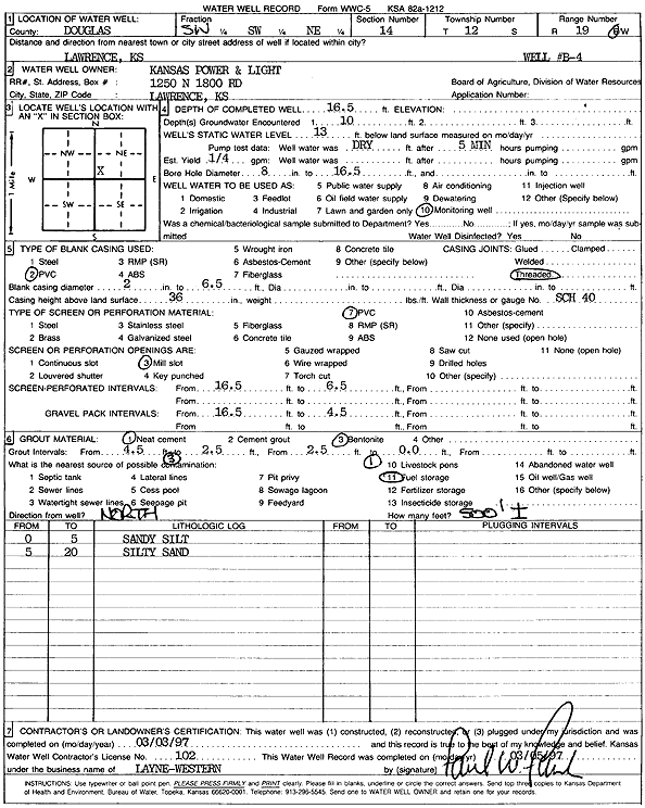
T12S, R19E, Sec. 14 SW SW NE |
Kansas Power and Light | 16.5 ft. | 13 ft. | .25 gpm. | Monitoring well/observation/piezometer | Well B4 | Constructed | 03-Mar-1997 | Scan |
|
T12S, R19E, Sec. 14 SW SW NE |
Kansas Power and Light | 33.5 ft. | 20 ft. | .5 gpm. | Monitoring well/observation/piezometer | Well B2 | Constructed | 03-Mar-1997 | Scan |
|
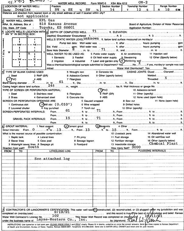
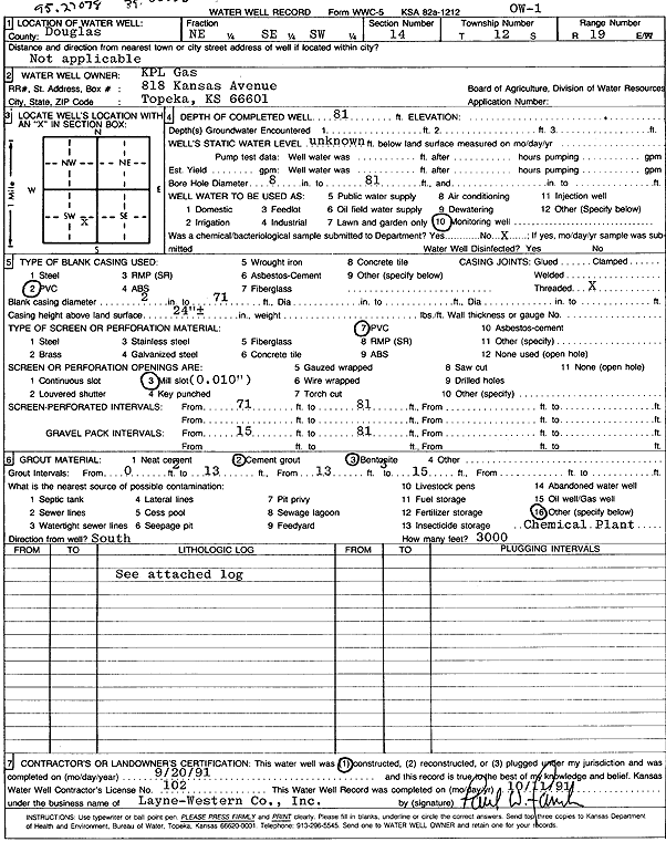
T12S, R19E, Sec. 14 NW SE SW |
KPL Gas | 71 ft. | Monitoring well/observation/piezometer | OW 2 | Constructed | 19-Sep-1991 | Scan | ||
|
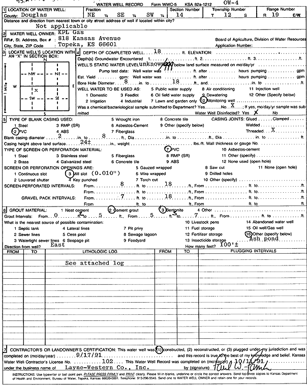
T12S, R19E, Sec. 14 NE SE SW |
KPL Gas | 23 ft. | Monitoring well/observation/piezometer | OW 5 | Constructed | 17-Sep-1991 | Scan | ||
|
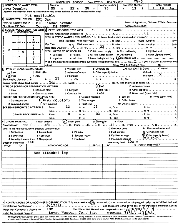
T12S, R19E, Sec. 14 NE SE SW |
KPL Gas | 18 ft. | Monitoring well/observation/piezometer | OW 4 | Constructed | 17-Sep-1991 | Scan | ||
|
T12S, R19E, Sec. 14 NE SE SW |
KPL Gas | 81 ft. | Monitoring well/observation/piezometer | OW 1 | Constructed | 20-Sep-1991 | Scan | ||
|
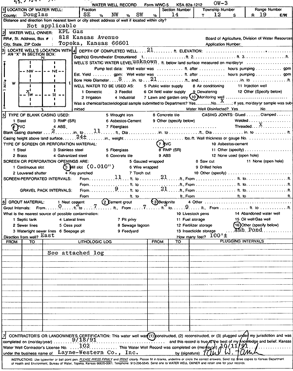
T12S, R19E, Sec. 14 SE NW SW |
KPL Gas | 21 ft. | Monitoring well/observation/piezometer | OW 3 | Constructed | 18-Sep-1991 | Scan | ||
|
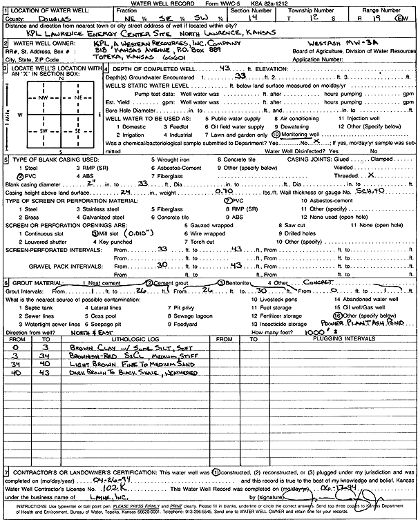
T12S, R19E, Sec. 14 NE SE SW |
KPL/Western Resources, Inc. | 43 ft. | Monitoring well/observation/piezometer | Wet Ash MW 3A | Constructed | 26-Apr-1994 | Scan | ||
|
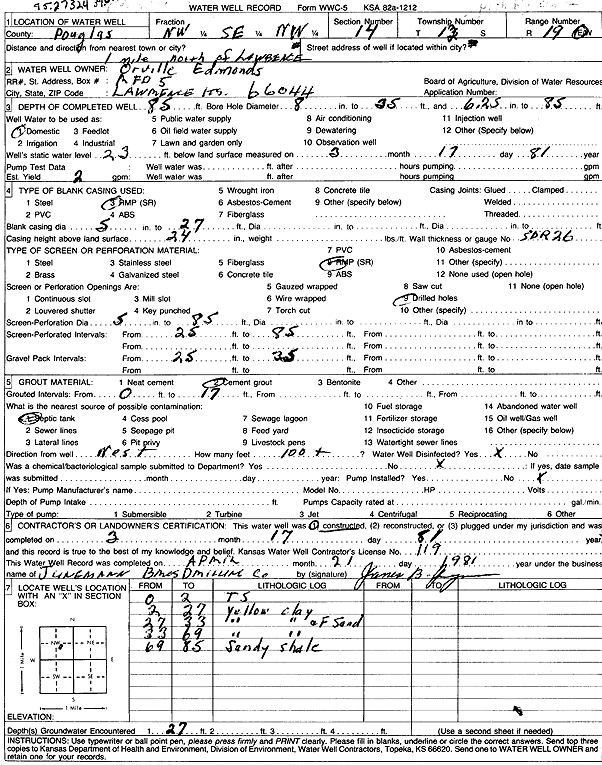
T12S, R19E, Sec. 14 NW SE NW |
Orville Edmonds | 85 ft. | 23 ft. | 2 gpm. | Domestic | Constructed | 17-Mar-1981 | Scan | |
|
T12S, R19E, Sec. 14 NW SE NW |
Westar | 43 ft. | 13 ft. | Industrial | Well 3 | Plugged | 29-Sep-2015 | ||
|
T12S, R19E, Sec. 14 NW NW NW |
Westar | 40 ft. | 13 ft. | Industrial | Well 5 | Plugged | 01-Oct-2015 | ||
|
T12S, R19E, Sec. 14 SW NW NW |
Westar | 52 ft. | 11 ft. | Industrial | Well 7 | Plugged | 01-Oct-2015 | ||
|
T12S, R19E, Sec. 14 SW SW NE |
Westar | 38 ft. | 18 ft. | Industrial | Well 1 | Plugged | 29-Sep-2015 | ||
|
T12S, R19E, Sec. 14 NW SE NW |
Westar | 43 ft. | 12 ft. | Industrial | Well 4 | Plugged | 01-Oct-2015 | ||
|
T12S, R19E, Sec. 14 NW NW NW |
Westar | 49 ft. | 13 ft. | Industrial | Well 6 | Plugged | 01-Oct-2015 | ||
|
T12S, R19E, Sec. 14 SE SE NW |
Westar | 48 ft. | 15 ft. | Industrial | Well 2 | Plugged | 29-Sep-2015 | ||
| View page: 1 || 2 || 3 || 4 || 5 || 6 || 7 || 8 || 9 || 10 || Next > | |||||||||