Select location of well to view details.
Click on column heading to sort.
|
|
|
County: Douglas Select location of well to view details. Click on column heading to sort. |
|
|
|
| View page: < Prev || 31 || 32 || 33 || 34 || 35 || 36 || 37 || 38 || 39 || 40 || Next > | |||||||||
| T-R-S | Owner | Well Depth Ascend. Desc. |
Static Water Level Ascend. Desc. |
Est. Yield Ascend. Desc. |
Well Use | Other ID | Action Taken | Completion Date Ascend. Desc. |
Scan? |
|
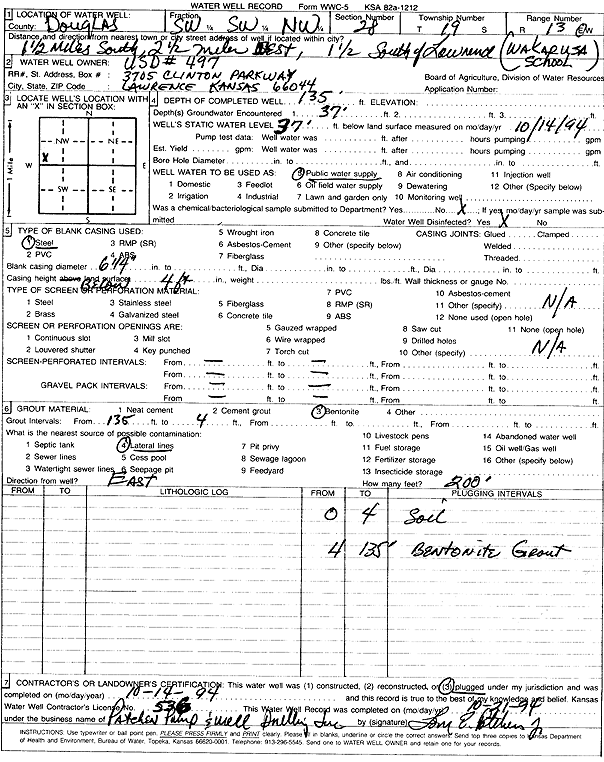
T13S, R19E, Sec. 28 SW SW NW |
USD 497 | 135 ft. | 37 ft. | Public Water Supply | Plugged | 14-Oct-1994 | Scan | ||
|
T13S, R19E, Sec. 29 NE NW SW NW |
A & H Heating and Cooling | 195 ft. | Geothermal, Closed Loop, Vertical | Constructed | 22-Jun-2021 |
KOLAR |
|||
|
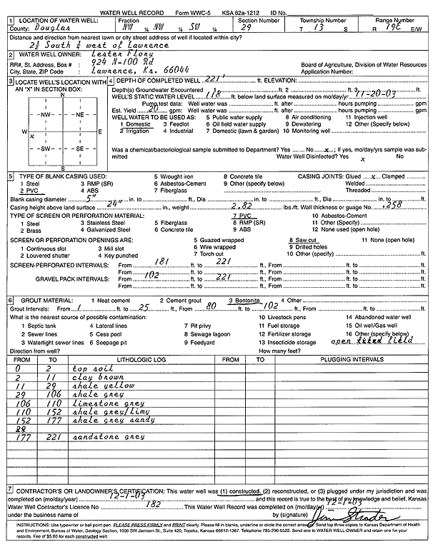
T13S, R19E, Sec. 29 NW NW SW |
Flory, Lester | 221 ft. | 118 ft. | 20 gpm. | Domestic | Constructed | 01-Dec-2003 | Scan | |
|
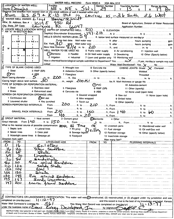
T13S, R19E, Sec. 29 NE NE SW |
Hammerschmidt, Lloyd | 210 ft. | 59 ft. | 30 gpm. | Domestic | Constructed | 12-Nov-1997 | Scan | |
|
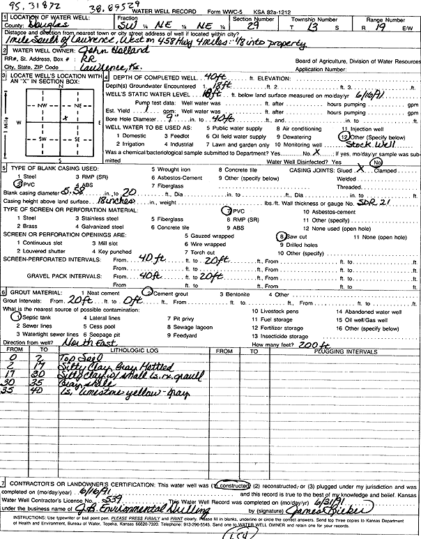
T13S, R19E, Sec. 29 SW NE NE |
Holland, John | 40 ft. | 18 ft. | 1 gpm. | Domestic, Livestock | Constructed | 16-Jun-1991 | Scan | |
|
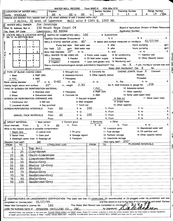
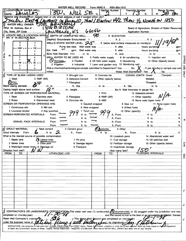
T13S, R19E, Sec. 29 SE SE NE |
Jennings, Joe | 100 ft. | 40 ft. | 10 gpm. | Domestic | Constructed | 27-Jan-1999 | Scan | |
|
T13S, R19E, Sec. 29 SE SW SW |
Struble, Bill | 200 ft. | 15 gpm. | Heat Pump (Closed Loop/Disposal), Geothermal | Constructed | 31-Aug-2010 | |||
|
T13S, R19E, Sec. 30 SW NW NE |
Smith, Nick | 190 ft. | Geothermal, Closed Loop, Vertical | Constructed | 18-Oct-2023 |
KOLAR |
|||
|
T13S, R19E, Sec. 30 SE SE NE |
Willem, Hendrick | 312 ft. | 193 ft. | 15 gpm. | Domestic | Constructed | 04-Oct-2002 | Scan | |
|
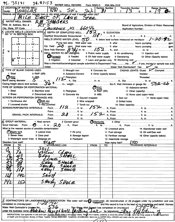
T13S, R19E, Sec. 31 NW SW SW |
Sanders, R.H. | 152 ft. | 50 ft. | 20 gpm. | Domestic | Constructed | 28-Jan-1992 | Scan | |
|
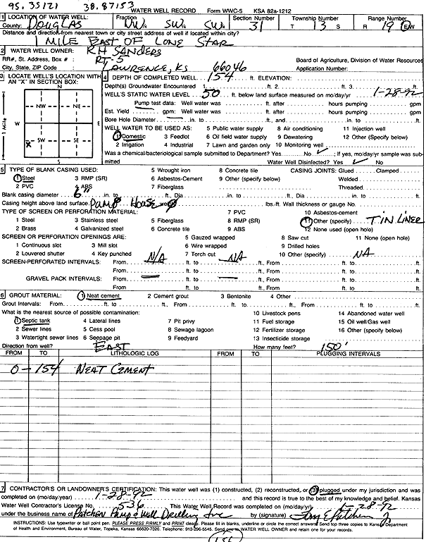
T13S, R19E, Sec. 31 NW SW SW |
Sanders, R.H. | 154 ft. | 50 ft. | Domestic | Plugged | 28-Jan-1992 | Scan | ||
|
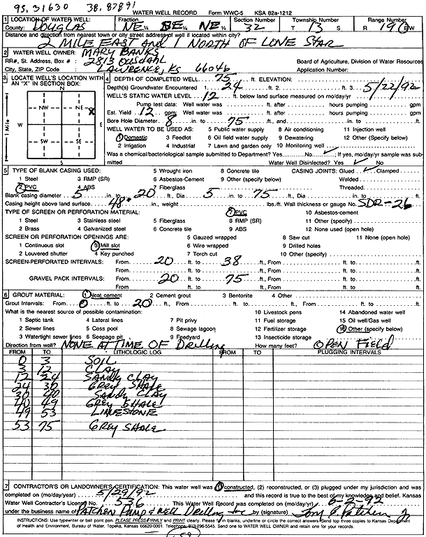
T13S, R19E, Sec. 32 NE SE NE |
Banks, Mary | 75 ft. | 12 ft. | 12 gpm. | Domestic | Constructed | 29-May-1992 | Scan | |
|
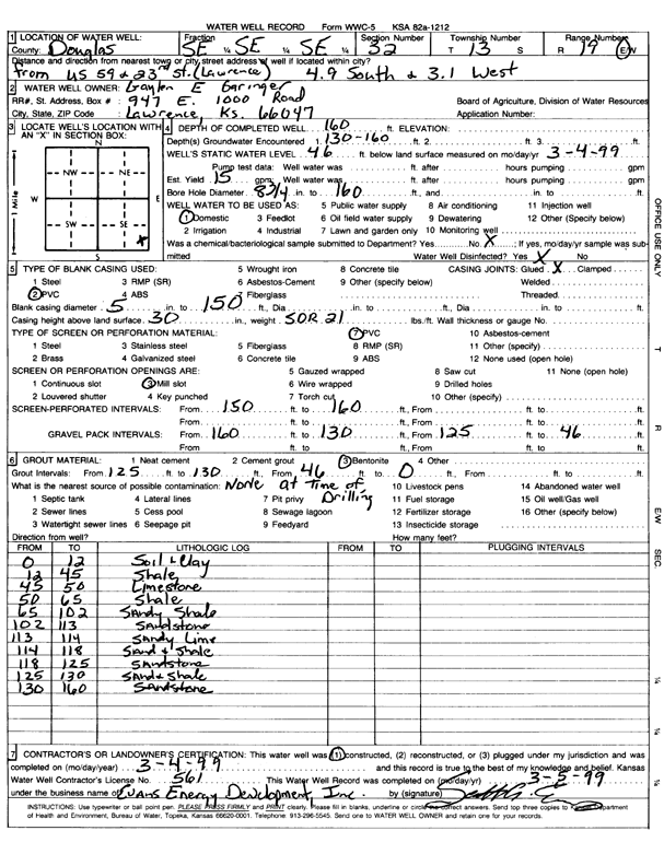
T13S, R19E, Sec. 32 SE SE SE |
Garinger, Gayler E. | 160 ft. | 46 ft. | 15 gpm. | Domestic | Constructed | 04-Mar-1999 | Scan | |
|
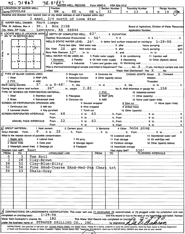
T13S, R19E, Sec. 32 NW SE NE |
Lumpe, Mark | 63 ft. | 26 ft. | 10 gpm. | Domestic | Constructed | 29-Jan-1990 | Scan | |
|
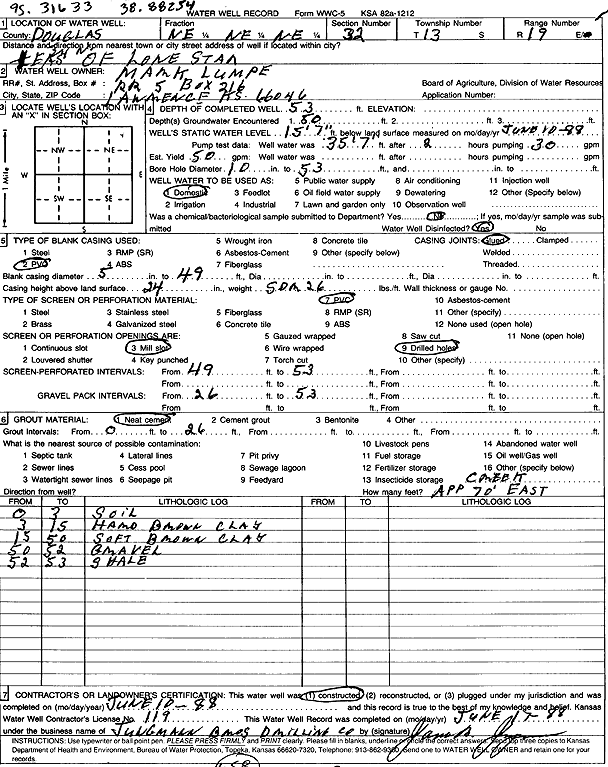
T13S, R19E, Sec. 32 NE NE NE |
Lumpe, Mark | 53 ft. | 15.58 ft. | 50 gpm. | Domestic | Constructed | 10-Jun-1988 | Scan | |
|
T13S, R19E, Sec. 32 NW SE SE |
Massaro, Jim | 220 ft. | 80 ft. | 15 gpm. | Domestic | Constructed | 30-May-2023 |
KOLAR |
|
|
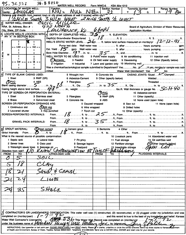
T13S, R19E, Sec. 32 NW NW NE |
Miller, Cecil | 35 ft. | 26 ft. | 15 gpm. | Domestic | Constructed | 07-Jan-1992 | Scan | |
|
T13S, R19E, Sec. 34 NE NE NE |
Burt | 190 ft. | Heat Pump (Closed Loop/Disposal), Geothermal | Constructed | 19-Jul-2010 | ||||
|
T13S, R19E, Sec. 34 NE SW NW NE |
Heinbach, Marvin | 180 ft. | Geothermal, Closed Loop, Vertical | Constructed | 19-Feb-2015 |
KOLAR |
|||
|
T13S, R19E, Sec. 34 NW SW NW NE |
Heinbach, Marvin | 318 ft. | 157 ft. | 15 gpm. | Domestic, Lawn and Garden | Constructed | 26-Jan-2022 |
KOLAR |
|
|
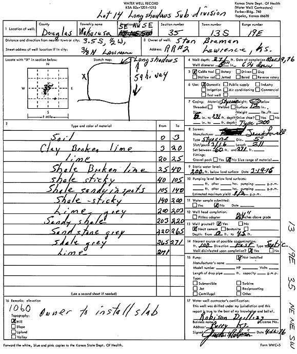
T13S, R19E, Sec. 35 SE NW SE |
Braman, Stan | 271 ft. | 200 ft. | .5 gpm. | Domestic | Constructed | 19-Mar-1976 | Scan | |
|
T13S, R19E, Sec. 35 SE NW NW |
Fayman, Sarah | 180 ft. | Geothermal, Closed Loop, Vertical | Constructed | 17-Apr-2024 |
KOLAR |
|||
|
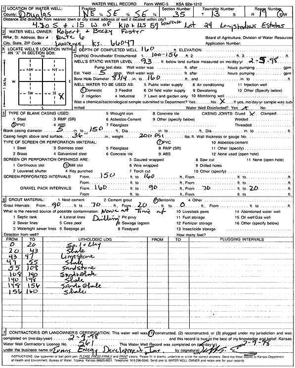
T13S, R19E, Sec. 35 NE SE SE |
Foster, Robert and Becky | 160 ft. | 93 ft. | 5 gpm. | Domestic | Constructed | 09-Feb-1998 | Scan | |
|
T13S, R19E, Sec. 35 SE SE NE |
Kerney, Dennis | 148 ft. | 72 ft. | Domestic | Reconstructed | 14-Oct-2008 | |||
|
T13S, R19E, Sec. 35 NW NW SE |
Manda, Ed and Catherine | 301 ft. | 228 ft. | 20 gpm. | Domestic, Lawn and Garden | Constructed | 16-Jan-2004 | Scan | |
|
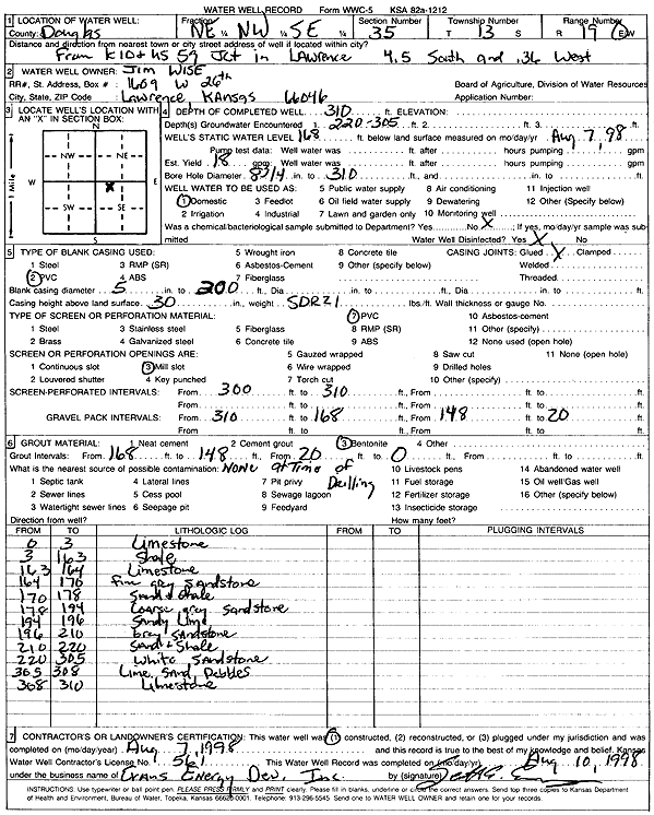
T13S, R19E, Sec. 35 NE NW SE |
Wise, Jim | 310 ft. | 168 ft. | 18 gpm. | Domestic | Constructed | 07-Aug-1998 | Scan | |
|
T13S, R19E, Sec. 36 NE NE NW |
Brown, Raymond | 128 ft. | 52 ft. | 7 gpm. | Domestic | Constructed | 07-Aug-1995 | Scan | |
|
T13S, R19E, Sec. 36 NE NW NW |
Douglas County | 15 ft. | Domestic | Plugged | 31-Jan-1994 | Scan | |||
|
T13S, R19E, Sec. 36 NE SW SE |
Findlay, R. Andrew | 340 ft. | 207 ft. | 4 gpm. | Domestic | Constructed | 06-Jan-2011 | ||
|
T13S, R19E, Sec. 36 SE NE NW |
Hoffman, Gary | 65 ft. | 12 ft. | 13.5 gpm. | Domestic | Constructed | 14-Jun-1976 | Scan | |
|
T13S, R19E, Sec. 36 NE NW SW |
Kansas Dept. of Transportation, KDOT | 68.8 ft. | Test Hole, Geotechnical | Constructed | 17-Jul-2006 | ||||
|
T13S, R19E, Sec. 36 NE NW SW |
Kansas Dept. of Transportation, KDOT | 97.5 ft. | Test Hole, Geotechnical | Constructed | 05-Jul-2006 | ||||
|
T13S, R19E, Sec. 36 NE SW SW |
KDOT | 89 ft. | 19 ft. | Domestic | Plugged | 14-Dec-2010 | |||
|
T13S, R19E, Sec. 36 NE NE NW |
Lassman, William | 140 ft. | 110 ft. | Domestic | Reconstructed | 06-Mar-1997 | Scan | ||
|
T13S, R19E, Sec. 36 SE SE NW |
Street, Bob | 120 ft. | 74 ft. | 8 gpm. | Domestic | Constructed | 10-Jul-1979 | Scan | |
|
T13S, R19E, Sec. 36 NE NE SW SE |
Sutter, Bill | 200 ft. | Geothermal, Closed Loop, Vertical | Constructed | 22-Mar-2021 | ||||
|
T13S, R19E, Sec. 36 NW NE SW SE |
Sutter, Lynette | 260 ft. | 31 ft. | 2.5 gpm. | Domestic | Constructed | 04-Mar-2021 |
KOLAR |
|
|
T13S, R20E, Sec. 1 C NE SW |
Altenburn, E.C. | 57 ft. | 20 ft. | 800 gpm. | Irrigation | Constructed | 15-Nov-1977 | Scan | |
|
T13S, R20E, Sec. 1 NW SW SW |
Boehle, Harold | 50 ft. | 22 ft. | 50 gpm. | Domestic | Constructed | 15-Feb-1993 | Scan | |
|
T13S, R20E, Sec. 1 NE NE SE |
M and M Oil Company | 25 ft. | Monitoring well/observation/piezometer | MW 9 | Constructed | 12-Sep-2013 | |||
|
T13S, R20E, Sec. 1 NE NE SE |
M and M Oil Company | 25 ft. | Monitoring well/observation/piezometer | MW 8 | Constructed | 12-Sep-2013 | |||
|
T13S, R20E, Sec. 1 NE SE SE |
Neis, Mark | 69 ft. | 15 ft. | Irrigation | Constructed | 09-Dec-2021 |
KOLAR |
||
|
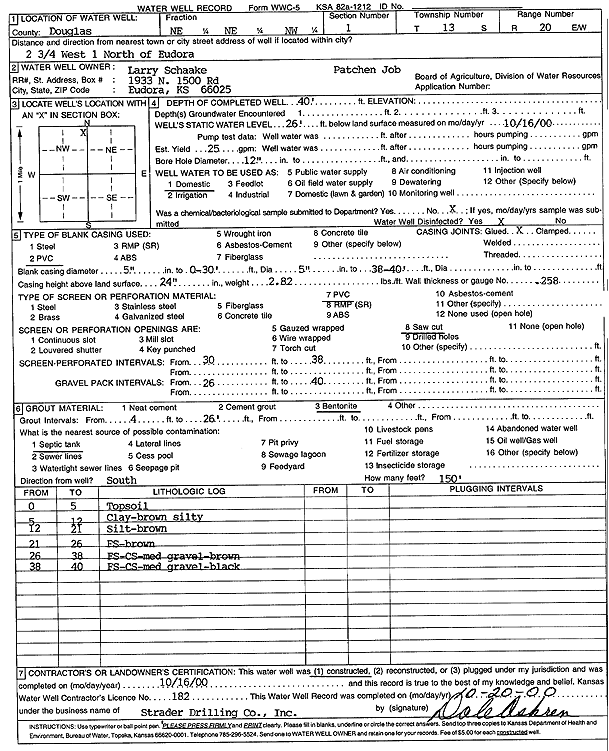
T13S, R20E, Sec. 1 NE NE NW |
Schaake, Larry | 40 ft. | 26 ft. | 25 gpm. | Domestic | Constructed | 16-Oct-2000 | Scan | |
|
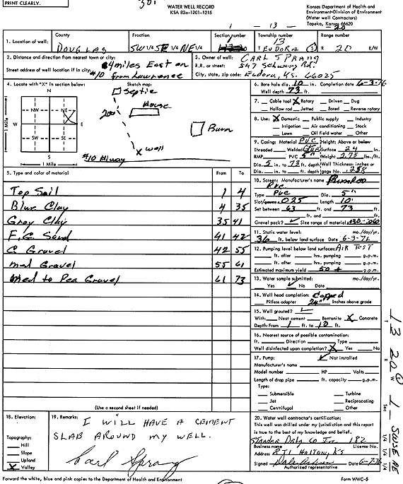
T13S, R20E, Sec. 1 SW SE NE |
Sprang, Carl | 73 ft. | 36 ft. | 50 gpm. | Domestic | Constructed | 03-Jun-1976 | Scan | |
|
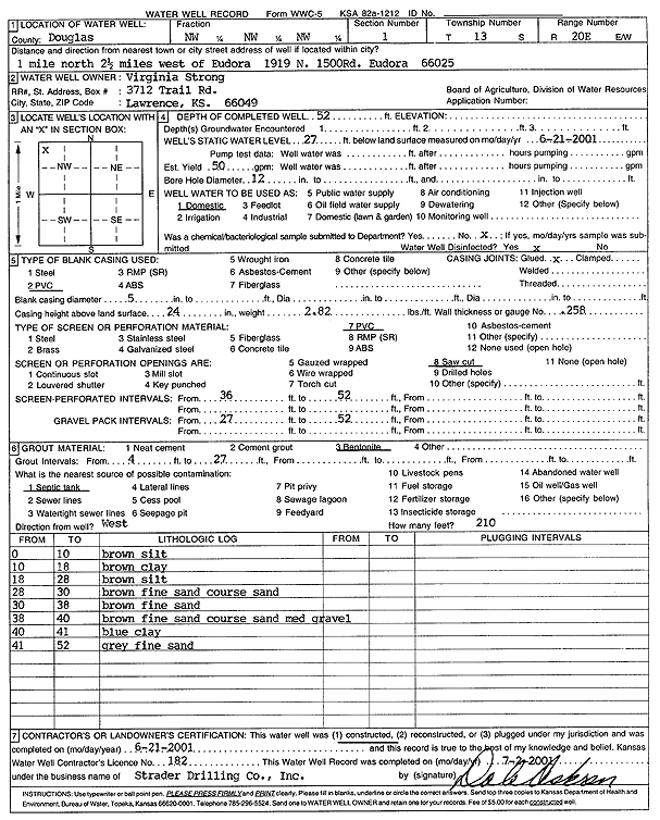
T13S, R20E, Sec. 1 NW NW NW |
Strong, Virginia | 52 ft. | 27 ft. | 50 gpm. | Domestic | Constructed | 21-Jun-2001 | Scan | |
|
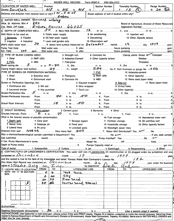
T13S, R20E, Sec. 1 NE NE NE |
Whaley, Howard | 50 ft. | 30 ft. | 100 gpm. | Domestic | Constructed | 19-Dec-1979 | Scan | |
|
T13S, R20E, Sec. 2 SW NW SE |
Arneson, Joe | 90 ft. | 25 ft. | Domestic | Reconstructed | 20-Nov-1998 | Scan | ||
|
T13S, R20E, Sec. 2 NW SW NW |
City of Lawrence | 77 ft. | 26 ft. | Industrial | Well 4 R | Plugged | 11-Jan-2017 | ||
|
T13S, R20E, Sec. 2 SE SW NW |
City of Lawrence | 69 ft. | 24 ft. | Industrial | Well 2 | Plugged | 11-Jan-2017 | ||
|
T13S, R20E, Sec. 2 SW SW NW |
City of Lawrence | 80 ft. | 26 ft. | Industrial | Well 1 R | Plugged | 11-Jan-2017 | ||
| View page: < Prev || 31 || 32 || 33 || 34 || 35 || 36 || 37 || 38 || 39 || 40 || Next > | |||||||||