Select location of well to view details.
Click on column heading to sort.
|
|
|
County: Douglas Select location of well to view details. Click on column heading to sort. |
|
|
|
| View page: < Prev || 41 || 42 || 43 || 44 || 45 || 46 || 47 || 48 || 49 || 50 || Next > | |||||||||
| T-R-S | Owner | Well Depth Ascend. Desc. |
Static Water Level Ascend. Desc. |
Est. Yield Ascend. Desc. |
Well Use | Other ID | Action Taken | Completion Date Ascend. Desc. |
Scan? |
|
T13S, R20E, Sec. 27 NW NE NW NE |
Lutz, Alhalie | 203 ft. | 131 ft. | 15 gpm. | Domestic | Constructed | 23-Jun-2016 |
KOLAR |
|
|
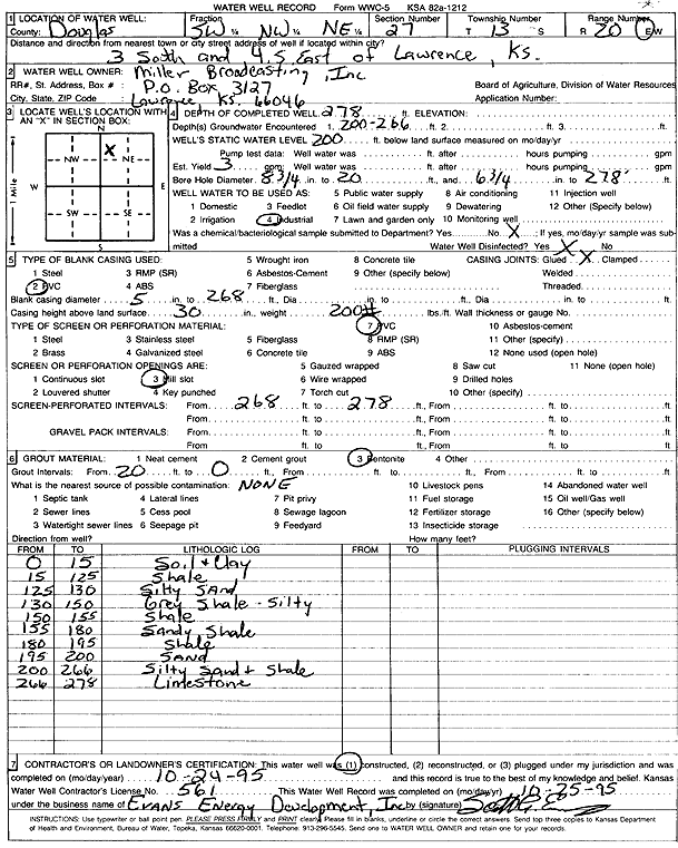
T13S, R20E, Sec. 27 SW NW NE |
Miller Broadcasting, Inc. | 278 ft. | 200 ft. | 3 gpm. | Industrial | Constructed | 24-Oct-1995 | Scan | |
|
T13S, R20E, Sec. 27 SW SW SW |
Mitchell, Susan | 110 ft. | 70 ft. | Domestic | Plugged | 15-Jan-2010 | |||
|
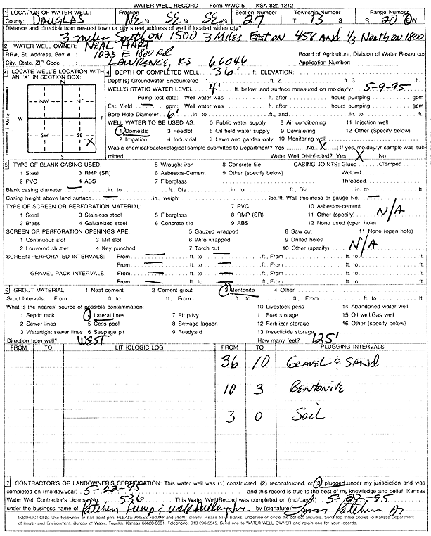
T13S, R20E, Sec. 27 NE SE SE |
Neal Hart | 36 ft. | 4 ft. | Domestic | Plugged | 22-May-1995 | Scan | ||
|
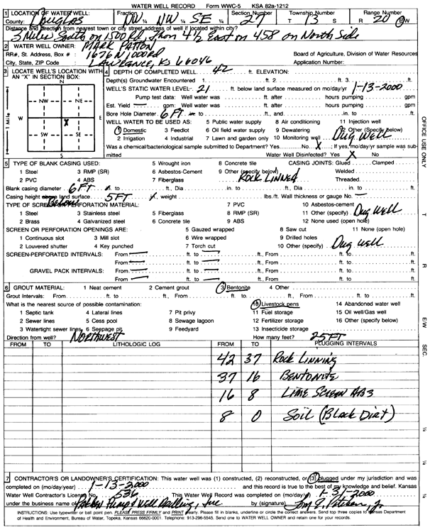
T13S, R20E, Sec. 27 NW NW SE |
Patton, Mark | 42 ft. | 21 ft. | Domestic | Plugged | 13-Jan-2000 | Scan | ||
|
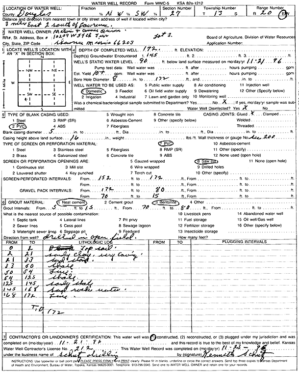
T13S, R20E, Sec. 27 NW SW |
Quinn, Melvin and Connie | 172 ft. | 90 ft. | 10 gpm. | Domestic | Constructed | 21-Nov-1996 | Scan | |
|
T13S, R20E, Sec. 27 NE SW SE NW |
Walker, Kyle | 200 ft. | 90 ft. | 12 gpm. | Geothermal, Closed Loop, Vertical | Constructed | 29-Aug-2012 | ||
|
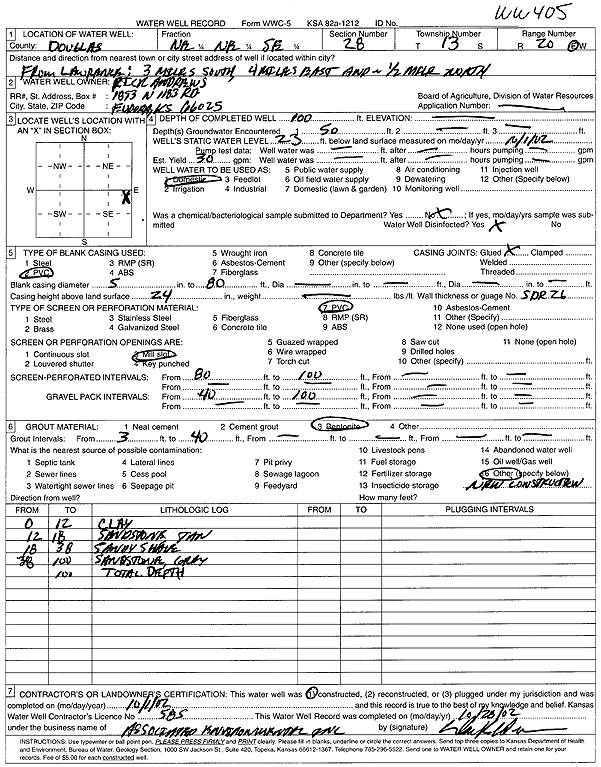
T13S, R20E, Sec. 28 NE NE SE |
Andrews, Rick | 100 ft. | 23 ft. | 30 gpm. | Domestic | WW 405 | Constructed | 01-Oct-2002 | Scan |
|
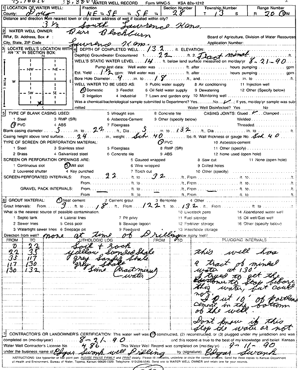
T13S, R20E, Sec. 28 NE SE SE |
Blackburn, Burr | 132 ft. | 14 ft. | 1.5 gpm. | Domestic | Constructed | 21-Aug-1990 | Scan | |
|
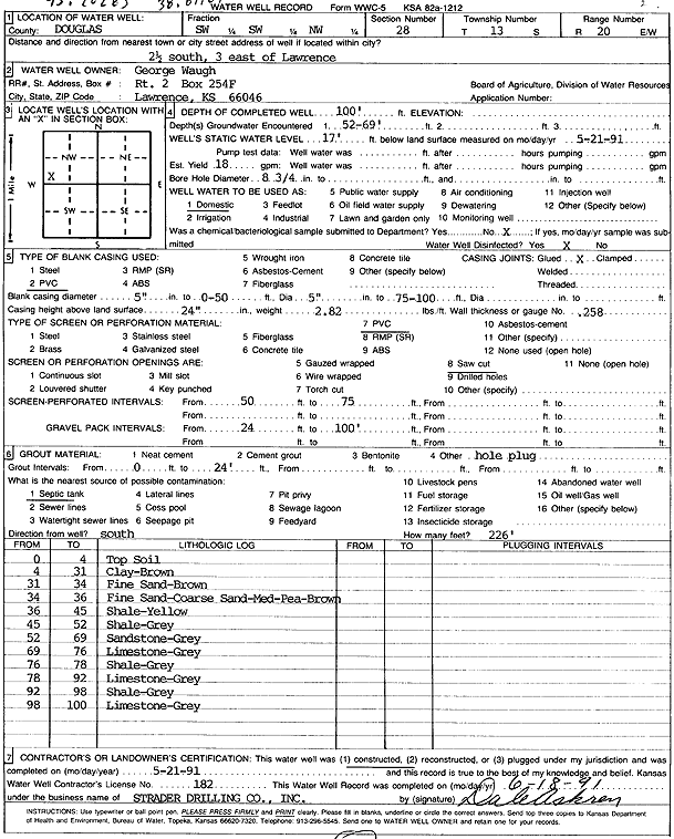
T13S, R20E, Sec. 28 SW SW NW |
Waugh, George | 100 ft. | 17 ft. | 18 gpm. | Domestic | Constructed | 21-May-1991 | Scan | |
|
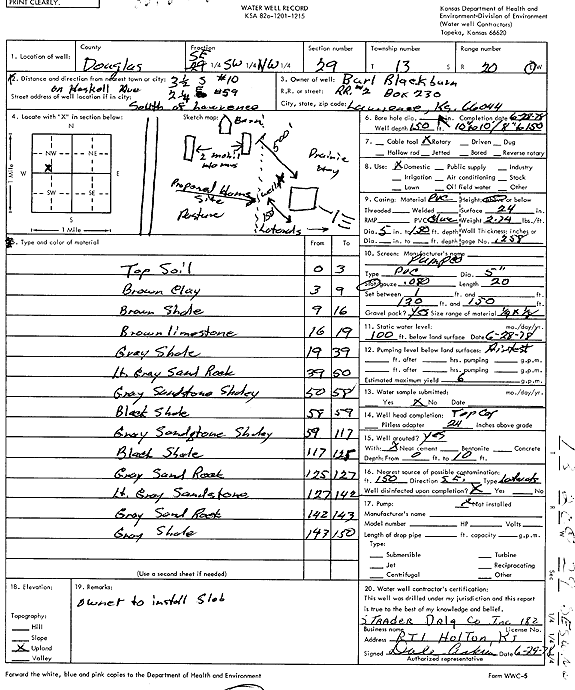
T13S, R20E, Sec. 29 SE SW NW |
Blackburn, Burl | 150 ft. | 100 ft. | 6 gpm. | Domestic | Constructed | 28-Jun-1978 | Scan | |
|
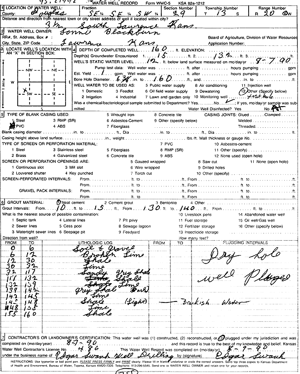
T13S, R20E, Sec. 29 SE SE SW |
Blackburn, Lonnie | 160 ft. | 12 ft. | 1 gpm. | Test hole/well | Plugged | 07-Aug-1990 | Scan | |
|
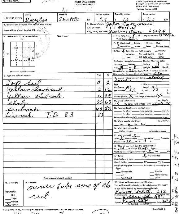
T13S, R20E, Sec. 29 NE SE NE |
Coleman, John | 83 ft. | 15 ft. | Domestic | Constructed | 15-Dec-1976 | Scan | ||
|
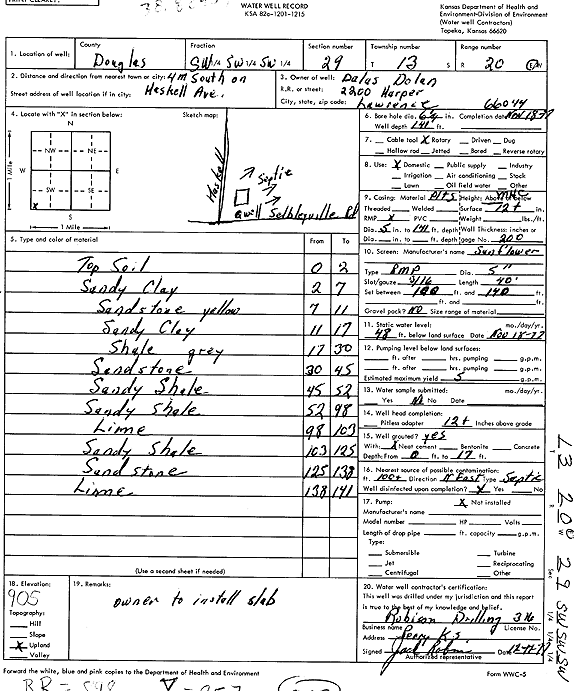
T13S, R20E, Sec. 29 SW SW SW |
Dolan, Dalas | 141 ft. | 48 ft. | 5 gpm. | Domestic | Constructed | 18-Nov-1977 | Scan | |
|
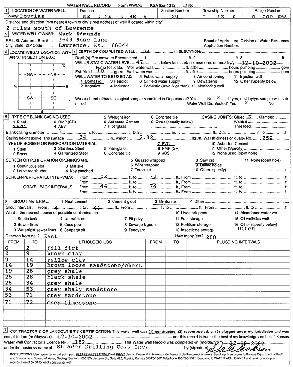
T13S, R20E, Sec. 29 NE NE NE |
Edmunds, Mark | 74 ft. | 47 ft. | 10 gpm. | Domestic | Constructed | 10-Dec-2002 | Scan | |
|
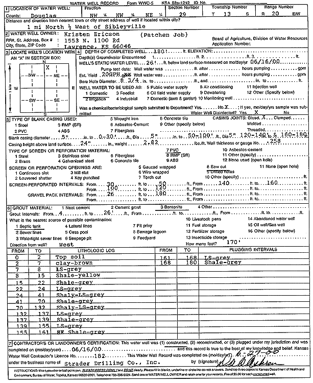
T13S, R20E, Sec. 29 NW NW NE |
Ericson, Kristen | 180 ft. | 26 ft. | .33 gpm. | Domestic | Constructed | 16-Jun-2000 | Scan | |
|
T13S, R20E, Sec. 29 SW SW SW |
Fine, Marvin J. | 160 ft. | 90 ft. | 10 gpm. | Domestic | Constructed | 14-Aug-1979 | ||
|
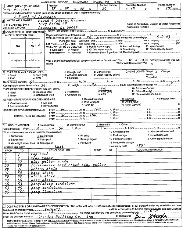
T13S, R20E, Sec. 29 SE NE NE |
Grammer, David and Sheryl | 100 ft. | 50 ft. | 15 gpm. | Domestic | Constructed | 10-Sep-2003 | Scan | |
|
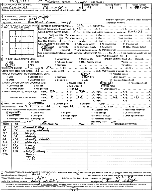
T13S, R20E, Sec. 29 SE NW |
Griffin, Gary | 172 ft. | 75 ft. | 10 gpm. | Domestic | Constructed | 15-Sep-1989 | Scan | |
|
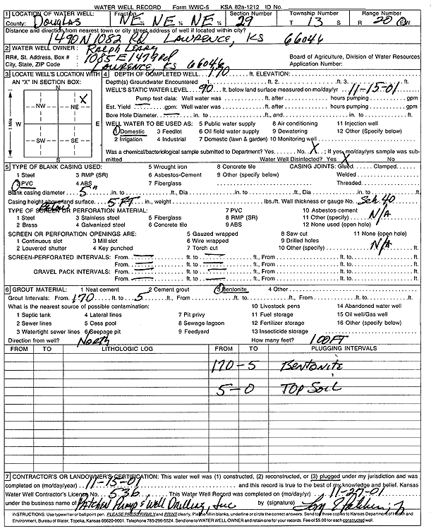
T13S, R20E, Sec. 29 NE NE NE |
Leary, Ralph | 170 ft. | 90 ft. | Domestic | Plugged | 15-Nov-2001 | Scan | ||
|
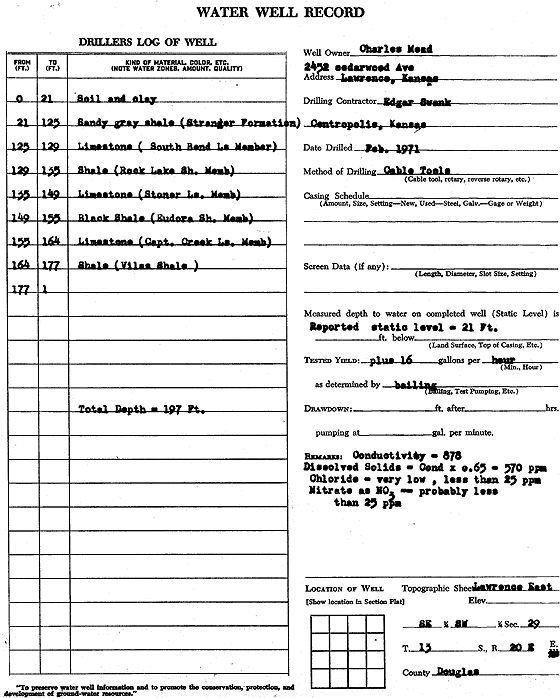
T13S, R20E, Sec. 29 SE SW |
Mead, Charles | 197 ft. | 21 ft. | .27 gpm. | Domestic | Constructed | 01-Feb-1971 | Scan | |
|
T13S, R20E, Sec. 29 NE SE SE SW |
Mead, Chuck | 137 ft. | 122 ft. | 10 gpm. | Domestic | Constructed | 18-Jun-2015 |
KOLAR |
|
|
T13S, R20E, Sec. 29 SE SE SW |
Mead, Chuck | 120 ft. | 60 ft. | Domestic | Plugged | 04-Aug-2015 | |||
|
T13S, R20E, Sec. 29 SE SE SW |
Mead, Chuck | 110 ft. | 45 ft. | Domestic | Reconstructed | 20-Apr-2007 | |||
|
T13S, R20E, Sec. 29 NW NE NE |
Midwest Homes, Inc. | 100 ft. | 44 ft. | 15 gpm. | Domestic | Constructed | 27-Jan-2005 | ||
|
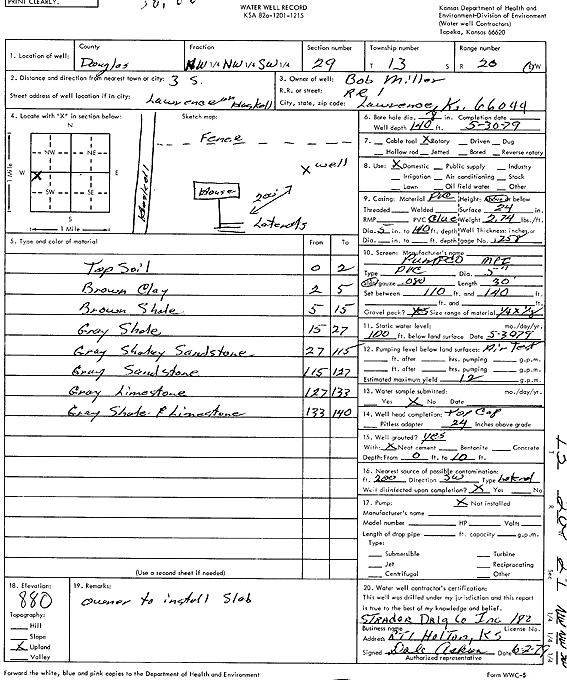
T13S, R20E, Sec. 29 NW NW SW |
Miller, Bob | 140 ft. | 100 ft. | 12 gpm. | Domestic | Constructed | 30-May-1979 | Scan | |
|
T13S, R20E, Sec. 29 SE SE SE SE |
Nichols, Brad | 200 ft. | 22 ft. | 20 gpm. | Geothermal, Closed Loop, Vertical | Constructed | 29-Apr-2015 |
KOLAR |
|
|
T13S, R20E, Sec. 29 SE NE NE |
Norris, Tim | 91 ft. | 55.48 ft. | 15 gpm. | Domestic, Lawn and Garden | Constructed | 05-Feb-2013 | ||
|
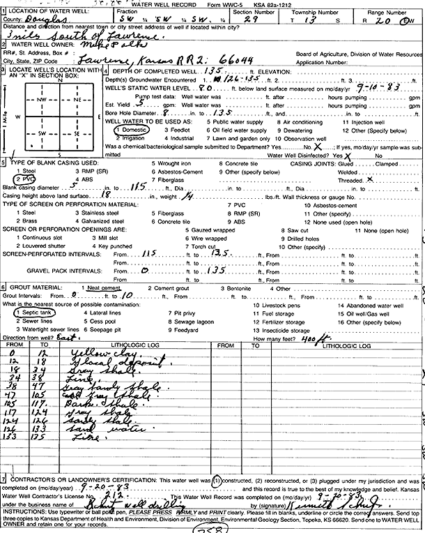
T13S, R20E, Sec. 29 SW SW SW |
Palk, Mike | 135 ft. | 80 ft. | 5 gpm. | Domestic | Constructed | 20-Sep-1983 | Scan | |
|
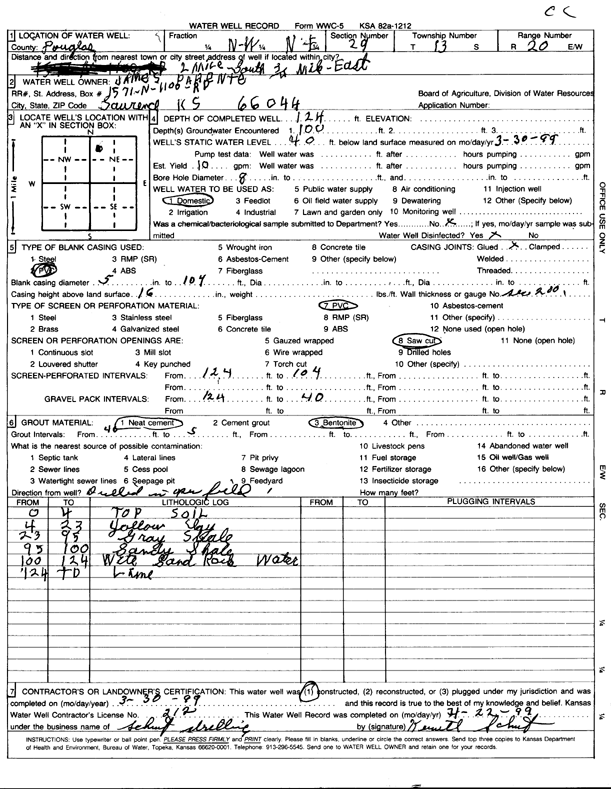
T13S, R20E, Sec. 29 NW NE |
Parente, James | 124 ft. | 40 ft. | 10 gpm. | Domestic | Constructed | 30-Mar-1999 | Scan | |
|
T13S, R20E, Sec. 29 NW NW SE |
Pine Family Farms | 160 ft. | 104 ft. | 7.5 gpm. | Irrigation | Constructed | 17-May-2007 | ||
|
T13S, R20E, Sec. 29 NW NW SE |
Pine Family Farms | 160 ft. | 102.5 ft. | 7 gpm. | Irrigation | Constructed | 17-May-2007 | ||
|
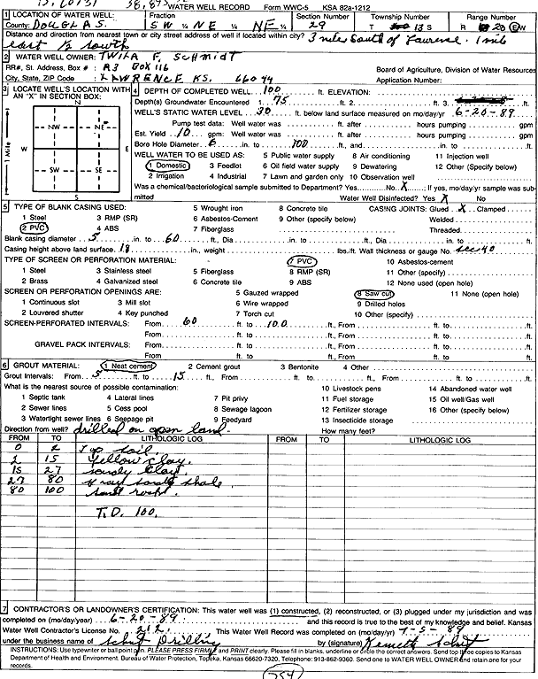
T13S, R20E, Sec. 29 SW NE NE |
Schmidt, Twila F. | 100 ft. | 30 ft. | 10 gpm. | Domestic | Constructed | 20-Jun-1989 | Scan | |
|
T13S, R20E, Sec. 29 NW SE SE NE |
Sellmeyer, Steve | 200 ft. | 110 ft. | 5 gpm. | Heat Pump (Closed Loop/Disposal), Geothermal | Constructed | 03-Aug-2011 | ||
|
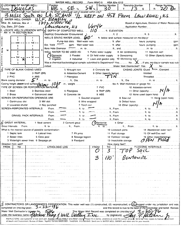
T13S, R20E, Sec. 30 NE SE SW |
Bradley, W.F. | 110 ft. | 60 ft. | Domestic | Plugged | 22-Mar-1996 | Scan | ||
|
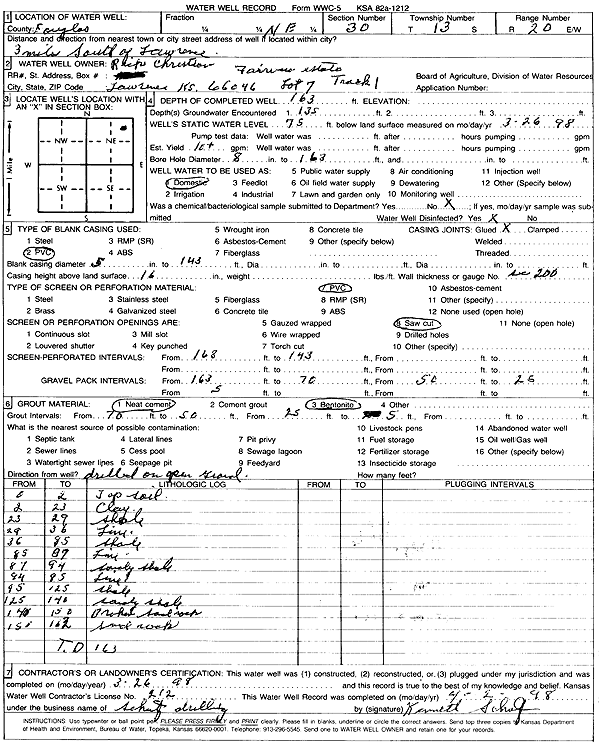
T13S, R20E, Sec. 30 NE |
Christian, Rick | 163 ft. | 75 ft. | 10 gpm. | Domestic | Constructed | 26-Mar-1998 | Scan | |
|
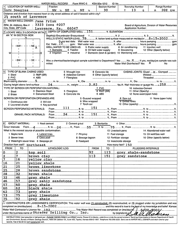
T13S, R20E, Sec. 30 NW SE NE |
Frink, Jame | 151 ft. | 79 ft. | 10 gpm. | Domestic | Constructed | 15-Aug-2002 | Scan | |
|
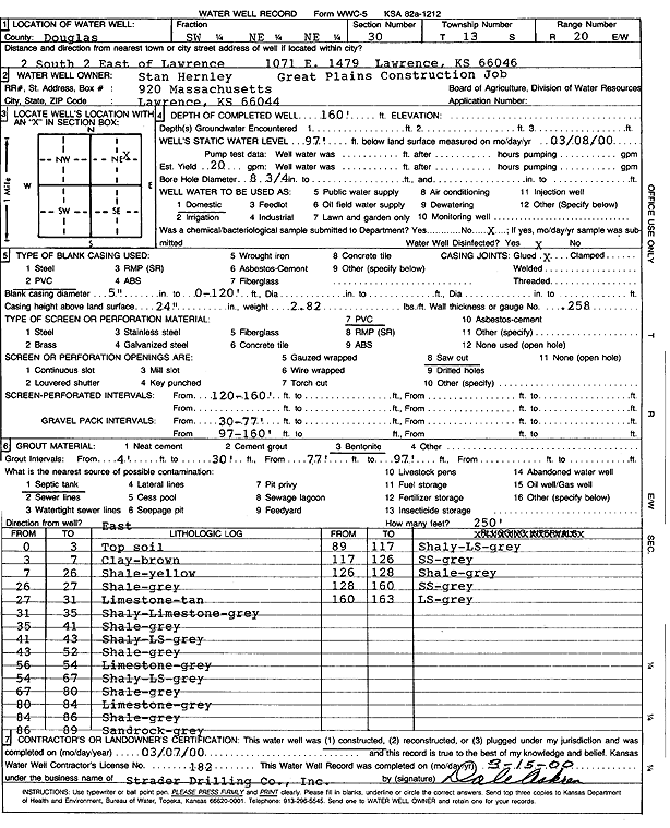
T13S, R20E, Sec. 30 SW NE NE |
Hernley, Stan | 160 ft. | 97 ft. | 20 gpm. | Domestic | Constructed | 07-Mar-2000 | Scan | |
|
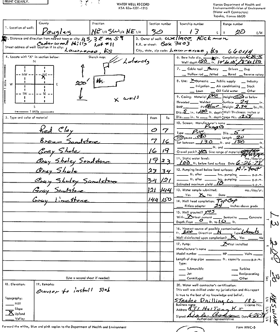
T13S, R20E, Sec. 30 NE SW NE |
Hickman, Wallace | 150 ft. | 100 ft. | 10 gpm. | Domestic | Constructed | 26-Jun-1976 | Scan | |
|
T13S, R20E, Sec. 30 SE SE NE |
Kelley, Mitch | 160 ft. | 100 ft. | 15 gpm. | Domestic | Constructed | 13-Nov-1998 | ||
|
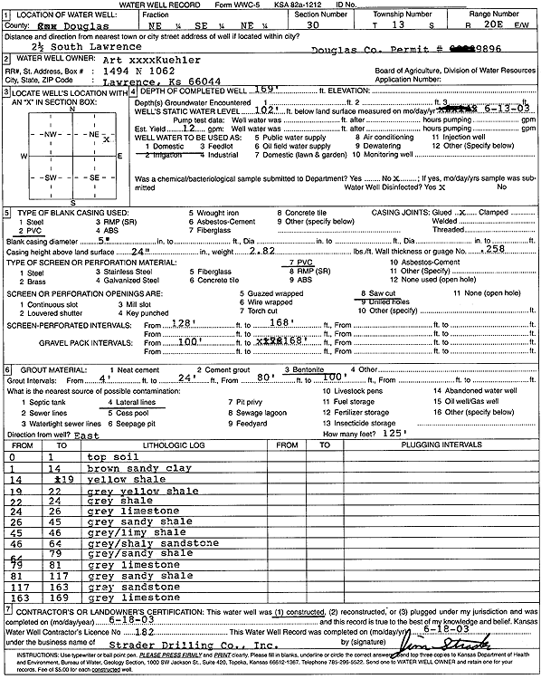
T13S, R20E, Sec. 30 NE SE NE |
Kuehler, Art | 169 ft. | 102 ft. | 12 gpm. | Domestic | Constructed | 18-Jun-2003 | Scan | |
|
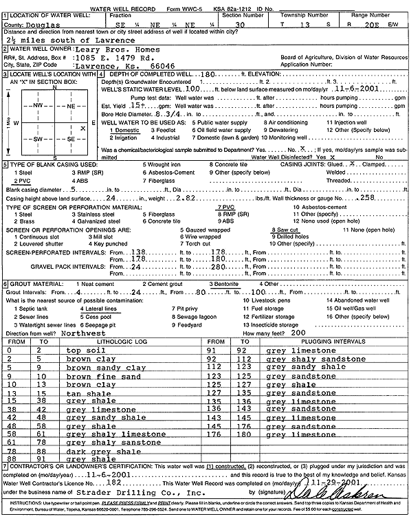
T13S, R20E, Sec. 30 SE NE NE |
Leary Bros. | 160 ft. | 87 ft. | 15 gpm. | Domestic | Constructed | 05-Jan-2007 | ||
|
T13S, R20E, Sec. 30 NE NE NE |
Leary Brothers | 182 ft. | 85 ft. | 15 gpm. | Domestic | Constructed | 14-Dec-1993 | Scan | |
|
T13S, R20E, Sec. 30 NE NE NE |
Leary Brothers | 131 ft. | 53 ft. | 10 gpm. | Domestic | Constructed | 30-Jul-1994 | Scan | |
|
T13S, R20E, Sec. 30 SE NE NE |
Leary Brothers Homes | 180 ft. | 100 ft. | Domestic | Constructed | 06-Nov-2001 | Scan | ||
|
T13S, R20E, Sec. 30 SE NE NE |
Leary Brothers Homes | 165 ft. | 103 ft. | 12 gpm. | Domestic | Constructed | 13-Sep-2005 | ||
|
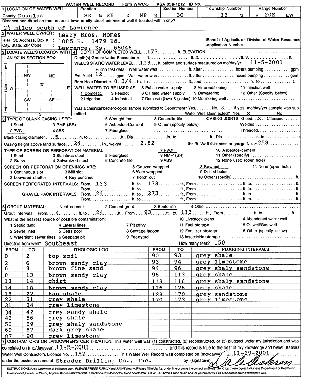
T13S, R20E, Sec. 30 SE SE NE |
Leary Brothers Homes | 173 ft. | 113 ft. | Domestic | Constructed | 05-Nov-2001 | Scan | ||
|
T13S, R20E, Sec. 30 SE NE NE |
Leary, Norman | 160 ft. | 106 ft. | 12 gpm. | Domestic | Constructed | 03-Aug-2004 | ||
|
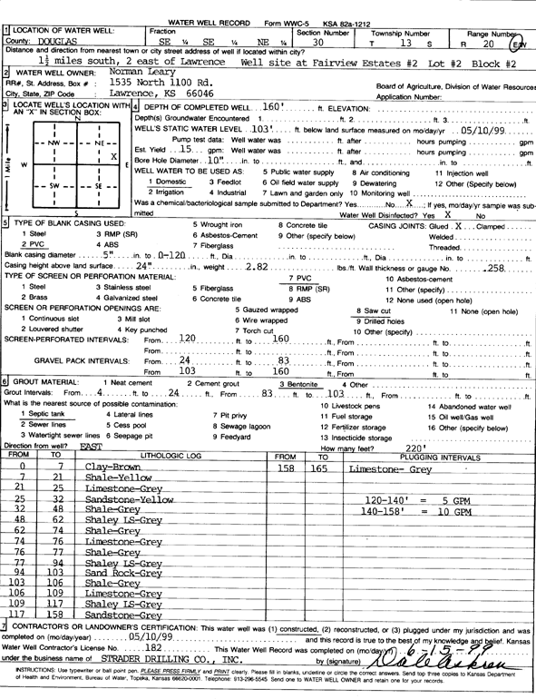
T13S, R20E, Sec. 30 SE SE NE |
Leary, Norman | 160 ft. | 103 ft. | 15 gpm. | Domestic | Constructed | 10-May-1999 | Scan | |
|
T13S, R20E, Sec. 30 NE NE NE |
Leary, Ralph | 162 ft. | 90 ft. | 10 gpm. | Domestic | Constructed | 25-Sep-1995 | Scan | |
| View page: < Prev || 41 || 42 || 43 || 44 || 45 || 46 || 47 || 48 || 49 || 50 || Next > | |||||||||