Select location of well to view details.
Click on column heading to sort.
|
|
|
County: Finney Select location of well to view details. Click on column heading to sort. |
|
|
|
| View page: < Prev || 101 || 102 || 103 || 104 || 105 || 106 || 107 || 108 || 109 || 110 | |||||||||
| T-R-S | Owner | Well Depth Ascend. Desc. |
Static Water Level Ascend. Desc. |
Est. Yield Ascend. Desc. |
Well Use | Other ID | Action Taken | Completion Date Ascend. Desc. |
Scan? |
|
T26S, R33W, Sec. 2 NW NE NE NW |
Hands, Cedric | 480 ft. | 252 ft. | 85 gpm. | Domestic | Constructed | 23-Apr-2013 | ||
|
T26S, R33W, Sec. 2 SW SW SW |
Hands, Fielding | 348 ft. | 88 ft. | Domestic | Constructed | 18-Aug-1980 | Scan | ||
|
T26S, R33W, Sec. 2 C SW |
Hands, Fielding | 452 ft. | 85 ft. | 1500 gpm. | Irrigation | Constructed | 03-Jul-1975 | Scan | |
|
T26S, R33W, Sec. 2 |
Hands, Greg | 481 ft. | 260 ft. | 180 gpm. | Domestic | Constructed | 08-May-2015 |
KOLAR |
|
|
T26S, R33W, Sec. 2 SW SW SW |
Hands, Greg | 347 ft. | 95 ft. | Domestic | Constructed | 26-Oct-1989 | Scan | ||
|
T26S, R33W, Sec. 2 NW NW SW |
Hands, Sam | 367 ft. | 152 ft. | Domestic | Constructed | 02-Jun-2002 | Scan | ||
|
T26S, R33W, Sec. 2 NW SE SW |
SFH Trust 89 | 565 ft. | 280 ft. | 600 gpm. | Irrigation | Constructed | 18-May-2023 |
KOLAR |
|
|
T26S, R33W, Sec. 2 NE |
Triangle H Grain and Cattle | 338 ft. | 200 ft. | Irrigation | Plugged | 27-Apr-2009 | |||
|
T26S, R33W, Sec. 2 SE SE NW NE |
Triangle H Grain and Cattle | 428 ft. | 203 ft. | Irrigation | Constructed | 13-Nov-2008 | |||
|
T26S, R33W, Sec. 3 NW SE |
Drussel, Gary | 440 ft. | 290 ft. | 50 gpm. | Domestic | Constructed | 25-Sep-2012 | ||
|
T26S, R33W, Sec. 3 SW SW NE |
Drussel, Gary | 310 ft. | 102 ft. | 25 gpm. | Domestic | Constructed | 23-Jan-1986 | Scan | |
|
T26S, R33W, Sec. 3 NW NE SW |
Hands, Fielding | 492 ft. | 100 ft. | 2000 gpm. | Irrigation | Constructed | 16-Dec-1985 | Scan | |
|
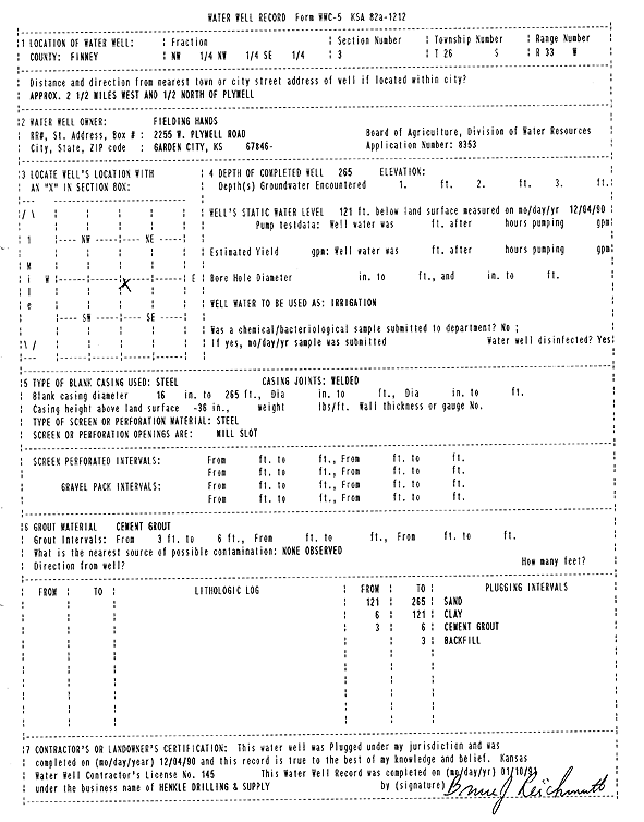
T26S, R33W, Sec. 3 NW NW SE |
Hands, Fielding | 265 ft. | 121 ft. | Irrigation | Plugged | 04-Dec-1990 | Scan | ||
|
T26S, R33W, Sec. 3 NE |
Triangle H Grain and Cattle | 300 ft. | 266 ft. | Irrigation | D 2 | Plugged | 17-Aug-2012 | ||
|
T26S, R33W, Sec. 3 SE NW SW |
Triangle H Grain and Cattle | 632 ft. | 277 ft. | 500 gpm. | Irrigation | Constructed | 21-Jun-2023 |
KOLAR |
|
|
T26S, R33W, Sec. 3 NE SW NE NE |
Triangle H Grain and Cattle | 499 ft. | 215 ft. | Irrigation | Constructed | 19-Mar-2009 | |||
|
T26S, R33W, Sec. 4 NE |
Hands, Floyd | 320 ft. | 128 ft. | Irrigation | Constructed | 15-Jul-1989 | Scan | ||
|
T26S, R33W, Sec. 4 NW NW SE |
Hands, Floyd | 308 ft. | 254 ft. | Irrigation | Plugged | 28-Feb-2017 | |||
|
T26S, R33W, Sec. 4 NW SW SW SE |
SFH Trust 89 | 496 ft. | 246 ft. | 1223 gpm. | Irrigation | Constructed | 16-Jan-2015 |
KOLAR |
|
|
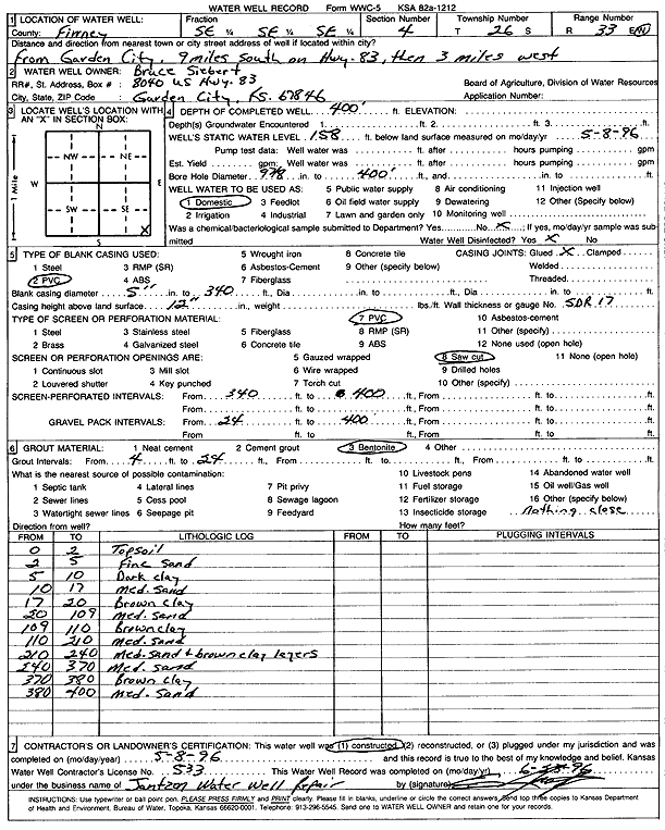
T26S, R33W, Sec. 4 SE SE SE |
Siebert, Bruce | 400 ft. | 158 ft. | Domestic | Constructed | 08-May-1996 | Scan | ||
|
T26S, R33W, Sec. 5 SW |
SCS Farms | 486 ft. | 124 ft. | 1650 gpm. | Irrigation | Constructed | 22-Sep-1980 | Scan | |
|
T26S, R33W, Sec. 5 SW SW SE |
Stone Acres Inc | 470 ft. | 233 ft. | Irrigation | Constructed | 12-Feb-2013 | |||
|
T26S, R33W, Sec. 5 SW SW NE |
Stone, Bill | 505 ft. | 202 ft. | 60 gpm. | Domestic | Constructed | 01-Feb-2005 | ||
|
T26S, R33W, Sec. 5 NE SE NW |
Tillman, Phyllis | 650 ft. | 314 ft. | 350 gpm. | Irrigation | Constructed | 06-Jun-2002 |
KOLAR |
|
|
T26S, R33W, Sec. 6 S |
Aylward Joint Venture | 270 ft. | 77 ft. | Domestic | Constructed | 17-Apr-1982 | Scan | ||
|
T26S, R33W, Sec. 6 NW SE NW |
Gigot-Stracklejohn | 351 ft. | 91 ft. | 1075 gpm. | Irrigation | Constructed | 23-Jun-1976 | Scan | |
|
T26S, R33W, Sec. 6 SW NE SW |
Gigot-Stracklejohn | 340 ft. | 88 ft. | 1200 gpm. | Irrigation | Constructed | 23-Jun-1976 | Scan | |
|
T26S, R33W, Sec. 6 SW NW NE NE |
SCS Farms | 425 ft. | 124 ft. | 1450 gpm. | Irrigation | Constructed | 22-Sep-1980 | Scan | |
|
T26S, R33W, Sec. 6 SE |
Stone, Steve | 375 ft. | 128 ft. | 1300 gpm. | Irrigation | Constructed | 31-Dec-1979 | Scan | |
|
T26S, R33W, Sec. 6 SW |
Tri Stone Farms | 320 ft. | 117 ft. | 1575 gpm. | Irrigation | Constructed | 31-Mar-1978 | Scan | |
|
T26S, R33W, Sec. 6 N2 NE |
Wheatland Electric Cooperative | 425 ft. | 240 ft. | Irrigation | Plugged | 23-Feb-2011 | |||
|
T26S, R33W, Sec. 6 NW NE |
Wheatland Electric Cooperative | 475 ft. | 227 ft. | Irrigation | Constructed | 04-Mar-2011 | |||
|
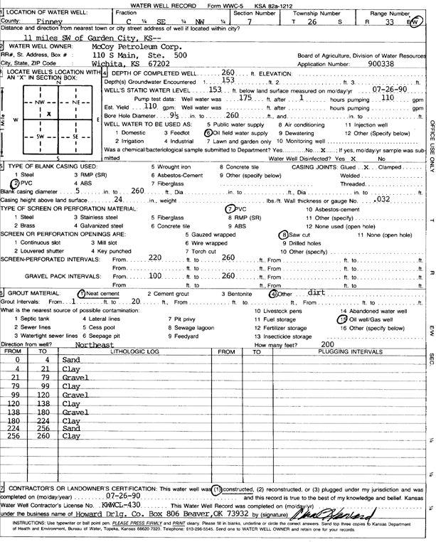
T26S, R33W, Sec. 7 C SE NW |
McCoy Petroleum Corp. | 260 ft. | 153 ft. | 110 gpm. | Oil Field Water Supply | Constructed | 26-Jul-1990 | Scan | |
|
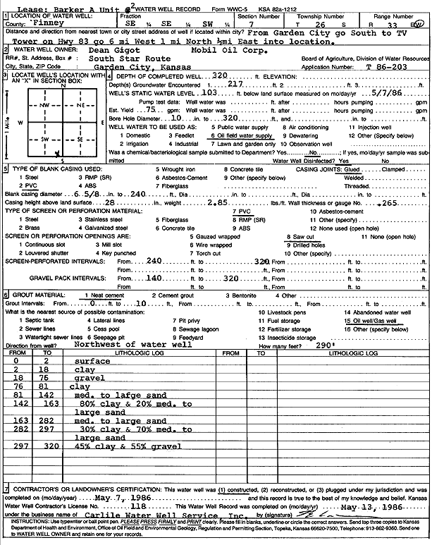
T26S, R33W, Sec. 7 SE SE SW |
Mobil Oil Corp./Gigot, Dean | 320 ft. | 103 ft. | 75 gpm. | Oil Field Water Supply | Barker B 1 | Constructed | 07-May-1986 | Scan |
|
T26S, R33W, Sec. 7 SW SW SE |
Stone, Billy | 470 ft. | 190 ft. | Domestic | Constructed | 26-Dec-2004 | |||
|
T26S, R33W, Sec. 7 SW |
Stone, Steve | 307 ft. | 92 ft. | 1500 gpm. | Irrigation | Constructed | 22-Sep-1980 | Scan | |
|
T26S, R33W, Sec. 8 NE NE NE NE |
Krause Farms | 475 ft. | 225 ft. | 50 gpm. | Domestic | Constructed | 14-Aug-2012 |
KOLAR |
|
|
T26S, R33W, Sec. 8 NE |
SCS Farms | 345 ft. | 98 ft. | 1550 gpm. | Irrigation | Constructed | 29-Feb-1980 | Scan | |
|
T26S, R33W, Sec. 8 NW |
SCS Farms | 335 ft. | 95 ft. | 1500 gpm. | Irrigation | Constructed | 29-Feb-1980 | Scan | |
|
T26S, R33W, Sec. 8 NW SE SE |
Stone, Art | 260 ft. | 120 ft. | Domestic, Livestock | Constructed | 31-Jul-1987 | Scan | ||
|
T26S, R33W, Sec. 8 NE SW SW |
Stone, Faye | 320 ft. | 61 ft. | 1200 gpm. | Irrigation | Constructed | 22-Aug-1975 | Scan | |
|
T26S, R33W, Sec. 8 SW SW SE |
Stone, Steve | 473 ft. | Domestic | Constructed | 03-Oct-2008 | ||||
|
T26S, R33W, Sec. 8 NW NW SE |
Stone, Steve | 470 ft. | 203 ft. | Irrigation | Test 2 | Constructed | 12-Feb-2007 | ||
|
T26S, R33W, Sec. 8 NW SW SW |
Tri Stone Farms | 465 ft. | 176 ft. | Irrigation | Constructed | 23-Apr-2002 | Scan | ||
|
T26S, R33W, Sec. 8 SE |
Tri Stone Farms | 190 ft. | Domestic | Plugged | 12-Dec-2016 | ||||
|
T26S, R33W, Sec. 8 SE |
Tri Stone Farms | 270 ft. | 263 ft. | Domestic | Plugged | 12-Dec-2016 | |||
|
T26S, R33W, Sec. 9 NE SW NE |
F. Arthur Stone Estate and Elnora A. Stone | 465 ft. | 127 ft. | Irrigation | Constructed | 28-Jan-1992 | Scan | ||
|
T26S, R33W, Sec. 9 SE SW SW NW |
SCS Farms | 230 ft. | 210 ft. | Irrigation | Plugged | 16-Dec-2009 | |||
|
T26S, R33W, Sec. 9 SE SW NW |
SCS Farms | 460 ft. | 204 ft. | Irrigation | Constructed | 19-Apr-2008 | |||
|
T26S, R33W, Sec. 9 NE SE SE |
SFH Trust | 508 ft. | 220 ft. | Irrigation | Constructed | 16-Dec-2010 | |||
| View page: < Prev || 101 || 102 || 103 || 104 || 105 || 106 || 107 || 108 || 109 || 110 | |||||||||