Select location of well to view details.
Click on column heading to sort.
|
|
|
County: Finney Select location of well to view details. Click on column heading to sort. |
|
|
|
| View page: < Prev || 41 || 42 || 43 || 44 || 45 || 46 || 47 || 48 || 49 || 50 || Next > | |||||||||
| T-R-S | Owner | Well Depth Ascend. Desc. |
Static Water Level Ascend. Desc. |
Est. Yield Ascend. Desc. |
Well Use | Other ID | Action Taken | Completion Date Ascend. Desc. |
Scan? |
|
T24S, R32W, Sec. 16 NE SE SE |
City of Garden City | 245 ft. | 75.7 ft. | Monitoring well/observation/piezometer | Jennie Barker Deep | Constructed | 29-Nov-2022 |
KOLAR |
|
|
T24S, R32W, Sec. 16 NW SE SE |
City of Garden City | 210 ft. | 75.2 ft. | Monitoring well/observation/piezometer | Jennie Barker Middle | Constructed | 30-Nov-2022 |
KOLAR |
|
|
T24S, R32W, Sec. 16 NW SE SE |
City of Garden City | 140 ft. | 69.8 ft. | Monitoring well/observation/piezometer | Jennie Barker Shallow | Constructed | 01-Dec-2022 |
KOLAR |
|
|
T24S, R32W, Sec. 16 SE SE SE |
Coastal Mart, Inc. | 27.5 ft. | Monitoring well/observation/piezometer | MW 5 | Plugged | 27-Sep-2004 | |||
|
T24S, R32W, Sec. 16 SE SE SE |
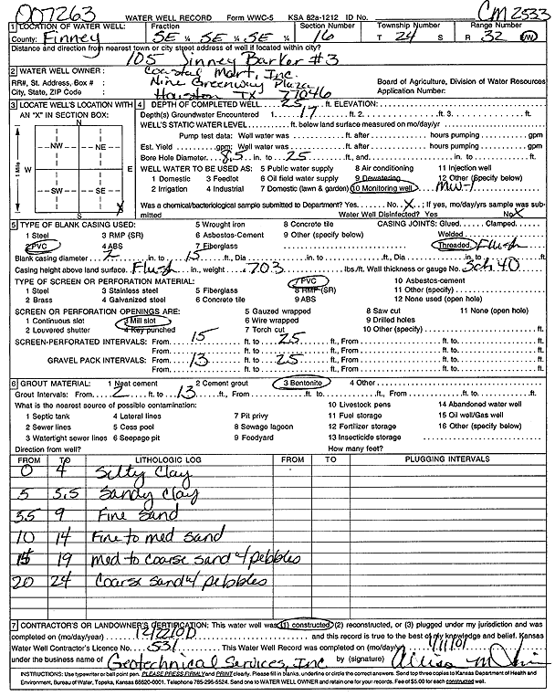
Coastal Mart, Inc. | 25 ft. | Monitoring well/observation/piezometer | MW 1 | Constructed | 22-Dec-2000 | Scan | ||
|
T24S, R32W, Sec. 16 SE SE SE |
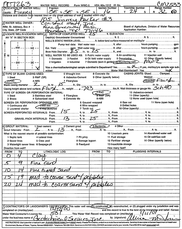
Coastal Mart, Inc. | 25 ft. | Monitoring well/observation/piezometer | MW 2 | Constructed | 22-Dec-2000 | Scan | ||
|
T24S, R32W, Sec. 16 SE SE SE |
Coastal Mart, Inc. | 24.74 ft. | Monitoring well/observation/piezometer | MW 2 | Plugged | 28-Sep-2004 | |||
|
T24S, R32W, Sec. 16 SE SE SE |
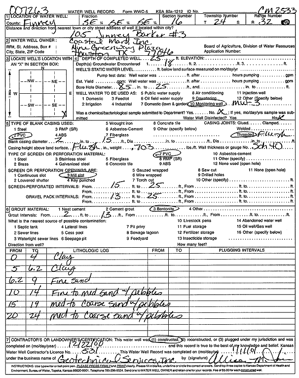
Coastal Mart, Inc. | 25 ft. | Monitoring well/observation/piezometer | MW 3 | Constructed | 22-Dec-2000 | Scan | ||
|
T24S, R32W, Sec. 16 SE SE SE |
Coastal Mart, Inc. | 27.5 ft. | Monitoring well/observation/piezometer | MW 7 | Plugged | 27-Sep-2004 | |||
|
T24S, R32W, Sec. 16 SE SE SE |
Coastal Mart, Inc. | 24.62 ft. | Monitoring well/observation/piezometer | MW 3 | Plugged | 28-Sep-2004 | |||
|
T24S, R32W, Sec. 16 SE SE SE |
Coastal Mart, Inc. | 27.5 ft. | Monitoring well/observation/piezometer | MW 4 | Plugged | 27-Sep-2004 | |||
|
T24S, R32W, Sec. 16 SE SE SE |
Coastal Mart, Inc. | 24.77 ft. | Monitoring well/observation/piezometer | MW 1 | Plugged | 27-Sep-2004 | |||
|
T24S, R32W, Sec. 16 SE SE SE |
Coastal Mart, Inc. | 28.12 ft. | Monitoring well/observation/piezometer | MW 8 | Plugged | 27-Sep-2004 | |||
|
T24S, R32W, Sec. 16 SE SE SE |
Coastal Mart, Inc. | 27.58 ft. | Monitoring well/observation/piezometer | MW 6 | Plugged | 28-Sep-2004 | |||
|
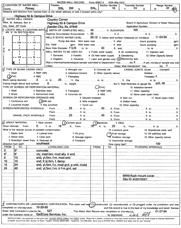
T24S, R32W, Sec. 16 SW SW SW |
Country Corner | 39.6 ft. | 39.25 ft. | Monitoring well/observation/piezometer | MW 9 | Plugged | 20-Oct-2006 | ||
|
T24S, R32W, Sec. 16 SW SW SW |
Country Corner | 41.8 ft. | Monitoring well/observation/piezometer | MW 1 | Plugged | 20-Oct-2006 | |||
|
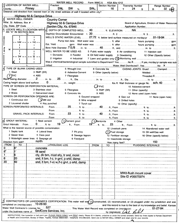
T24S, R32W, Sec. 16 SW SW SW |
Country Corner | 40 ft. | 27.72 ft. | Monitoring well/observation/piezometer | MW 3 | Constructed | 28-Oct-1993 | Scan | |
|
T24S, R32W, Sec. 16 SW SW SW |
Country Corner | 39.6 ft. | Monitoring well/observation/piezometer | MW 3 | Plugged | 20-Oct-2006 | |||
|
T24S, R32W, Sec. 16 SW SW SW |
Country Corner | 37.15 ft. | Monitoring well/observation/piezometer | MW 8 | Plugged | 20-Oct-2006 | |||
|
T24S, R32W, Sec. 16 SW SW SW |
Country Corner | 39.8 ft. | Monitoring well/observation/piezometer | MW 4 | Plugged | 20-Oct-2006 | |||
|
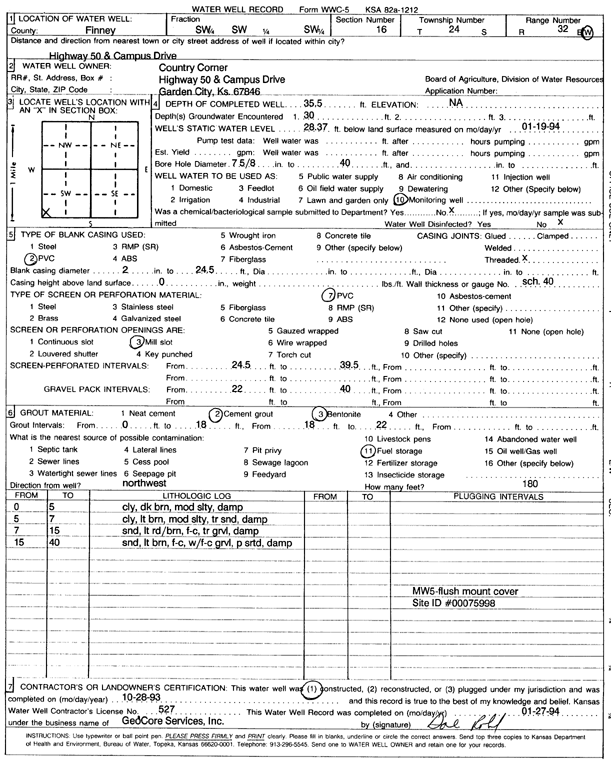
T24S, R32W, Sec. 16 SW SW SW |
Country Corner | 35.5 ft. | 28.37 ft. | Monitoring well/observation/piezometer | MW 5 | Constructed | 28-Oct-1993 | Scan | |
|
T24S, R32W, Sec. 16 SW SW SW |
Country Corner | 39.75 ft. | Monitoring well/observation/piezometer | MW 5 | Plugged | 20-Oct-2006 | |||
|
T24S, R32W, Sec. 16 SW SW SW |
Country Corner | 39.7 ft. | Monitoring well/observation/piezometer | MW 11 | Plugged | 20-Oct-2006 | |||
|
T24S, R32W, Sec. 16 SW SW SW |
Country Corner | 39.65 ft. | Monitoring well/observation/piezometer | MW 12 | Plugged | 20-Oct-2006 | |||
|
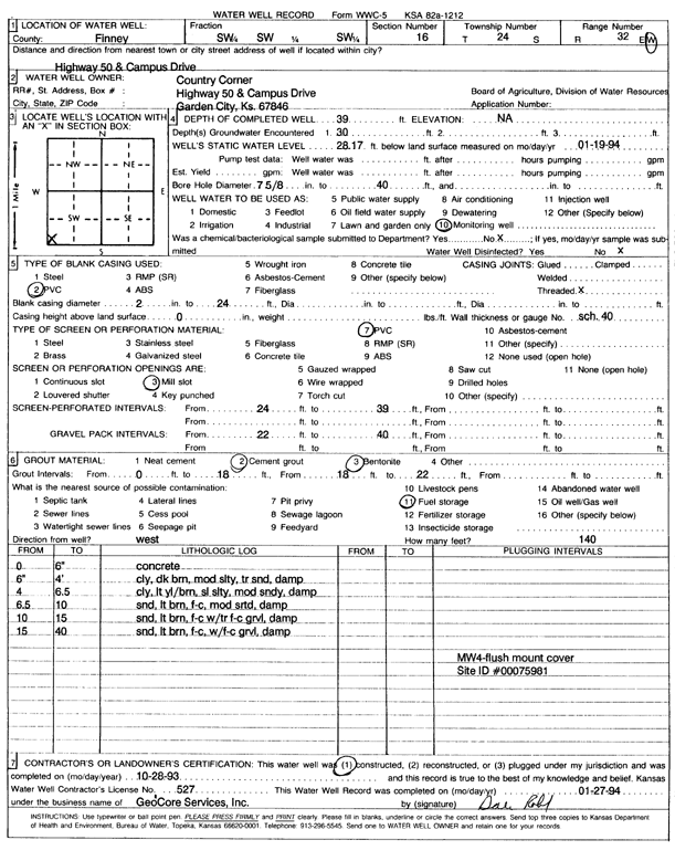
T24S, R32W, Sec. 16 SW SW SW |
Country Corner | 39 ft. | 28.17 ft. | Monitoring well/observation/piezometer | MW 4 | Constructed | 28-Oct-1993 | Scan | |
|
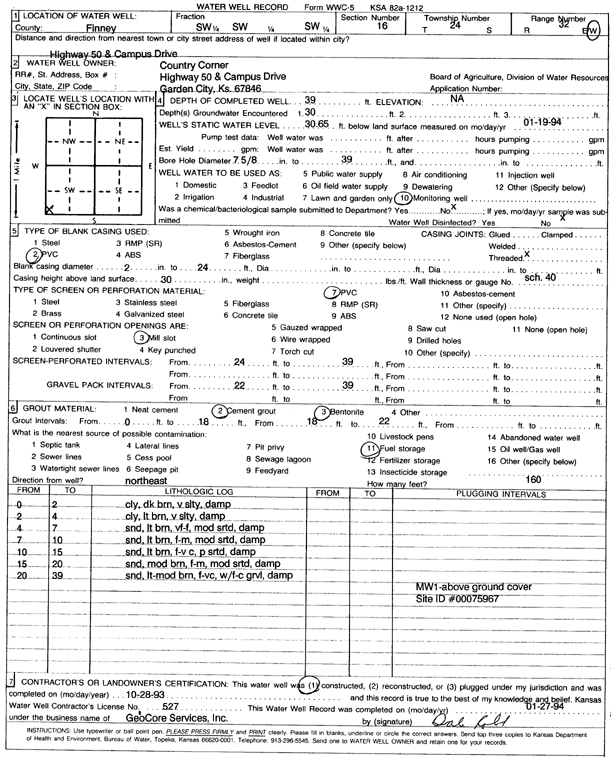
T24S, R32W, Sec. 16 SW SW SW |
Country Corner | 39 ft. | 30.65 ft. | Monitoring well/observation/piezometer | MW 1 | Constructed | 28-Oct-1993 | Scan | |
|
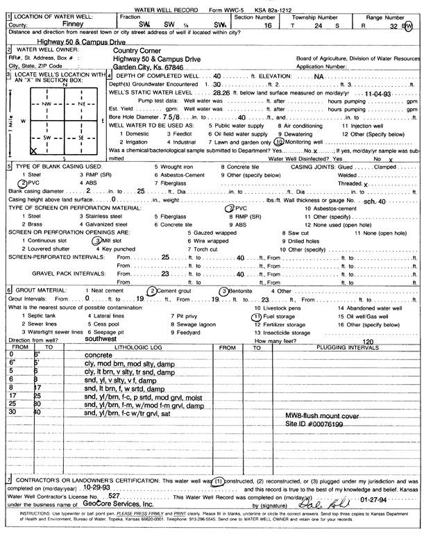
T24S, R32W, Sec. 16 SW SW SW |
Country Corner | 40 ft. | 28.26 ft. | Monitoring well/observation/piezometer | MW 8 | Constructed | 29-Oct-1993 | Scan | |
|
T24S, R32W, Sec. 16 SW SW SW |
Country Corner | 40 ft. | 28.12 ft. | Monitoring well/observation/piezometer | MW 9 | Constructed | 29-Oct-1993 | Scan | |
|
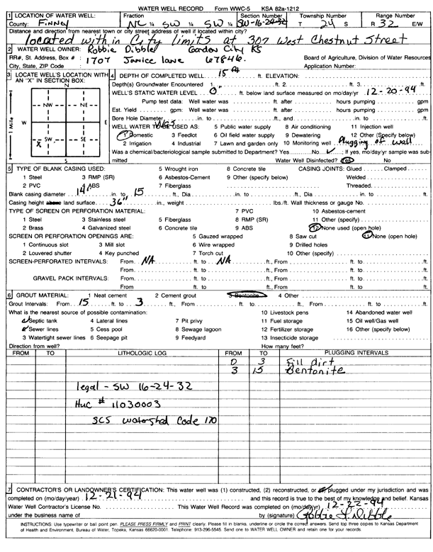
T24S, R32W, Sec. 16 C SW SW |
Dibble, Robbie | 15 ft. | Domestic | Plugged | 21-Dec-1994 | Scan | |||
|
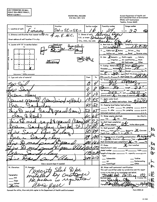
T24S, R32W, Sec. 16 SW SE SE |
Dyer, Alvin | 260 ft. | 31 ft. | Domestic | Constructed | 09-Oct-1975 | Scan | ||
|
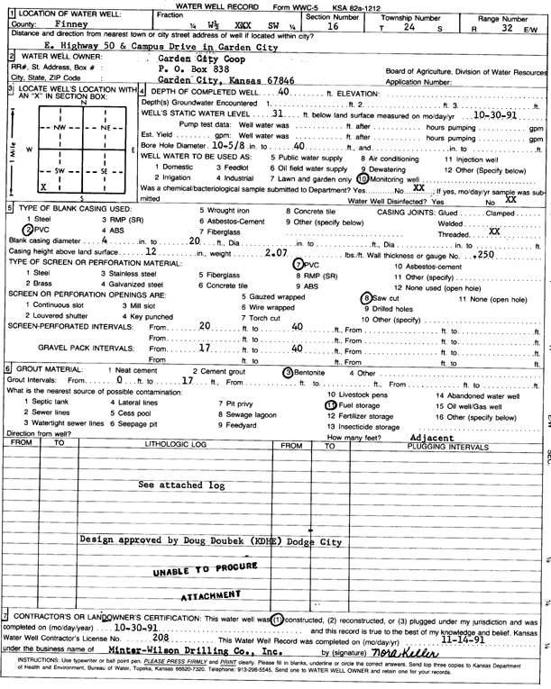
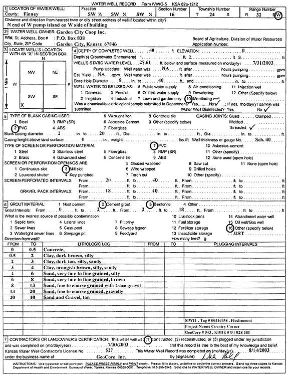
T24S, R32W, Sec. 16 W2 SW |
Garden City Coop | 40 ft. | 31 ft. | Monitoring well/observation/piezometer | Constructed | 30-Oct-1991 | Scan | ||
|
T24S, R32W, Sec. 16 SW SW SW |
Garden City Coop | 55 ft. | 43.6 ft. | Monitoring well/observation/piezometer | MW 3 R | Constructed | 19-Oct-2006 | ||
|
T24S, R32W, Sec. 16 SW SW SW |
Garden City Coop | 55 ft. | 44.8 ft. | Monitoring well/observation/piezometer | MW 9 R | Constructed | 18-Oct-2006 | ||
|
T24S, R32W, Sec. 16 SW SW SW |
Garden City Coop | 55 ft. | Monitoring well/observation/piezometer | MW 12 R | Constructed | 18-Oct-2006 | |||
|
T24S, R32W, Sec. 16 SW SW SW |
Garden City Coop | 55 ft. | Monitoring well/observation/piezometer | MW 11 R | Constructed | 17-Oct-2006 | |||
|
T24S, R32W, Sec. 16 SW SW SW |
Garden City Coop | 40 ft. | 27.84 ft. | Monitoring well/observation/piezometer | MW 12 | Constructed | 30-Jul-2003 | Scan | |
|
T24S, R32W, Sec. 16 SW SW SW |
Garden City Coop | 55 ft. | 43.8 ft. | Monitoring well/observation/piezometer | MW 4 R | Constructed | 18-Oct-2006 | ||
|
T24S, R32W, Sec. 16 SW SW SW |
Garden City Coop | 40 ft. | 27.61 ft. | Monitoring well/observation/piezometer | MW 11 | Constructed | 30-Jul-2003 | Scan | |
|
T24S, R32W, Sec. 16 SW SW SW |
Garden City Coop | 55 ft. | 44.4 ft. | Monitoring well/observation/piezometer | MW 1 R | Constructed | 17-Oct-2006 | ||
|
T24S, R32W, Sec. 16 SW SW SW |
Garden City Coop | 55 ft. | 43.8 ft. | Monitoring well/observation/piezometer | MW 5 R | Constructed | 17-Oct-2006 | ||
|
T24S, R32W, Sec. 16 SW SW SW NW |
Hybrid Seed Co. | 150 ft. | 50 ft. | Domestic | Plugged | 31-May-2007 | |||
|
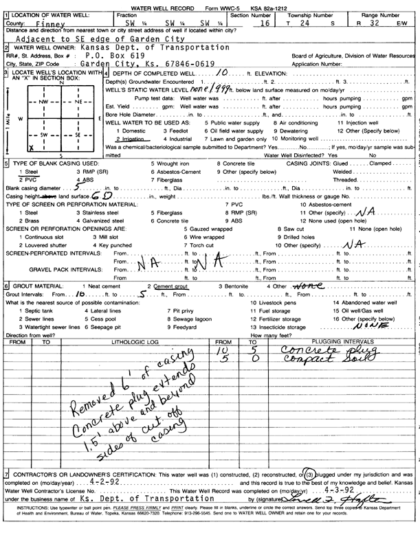
T24S, R32W, Sec. 16 SW SW SW |
Kansas Dept. of Transportation | 10 ft. | Irrigation | Plugged | 02-Apr-1992 | Scan | |||
|
T24S, R32W, Sec. 16 NW SW SW |
KDHE | 75 ft. | 59.99 ft. | Monitoring well/observation/piezometer | MW 4 D | Constructed | 18-May-2011 | ||
|
T24S, R32W, Sec. 16 NW SW SW |
KDHE | 74 ft. | 59.57 ft. | Monitoring well/observation/piezometer | MW 3 D | Constructed | 19-May-2011 | ||
|
T24S, R32W, Sec. 16 NW SW SW |
KDHE | 73.5 ft. | 60.07 ft. | Monitoring well/observation/piezometer | MW 5 D | Constructed | 18-May-2011 | ||
|
T24S, R32W, Sec. 16 SW SW SW |
KDHE | 74 ft. | 59.11 ft. | Monitoring well/observation/piezometer | MW 12 D | Constructed | 24-May-2011 | ||
|
T24S, R32W, Sec. 16 SW SW SW |
KDHE | 75 ft. | 59.3 ft. | Monitoring well/observation/piezometer | MW 13 D | Constructed | 24-May-2011 | ||
|
T24S, R32W, Sec. 16 NW SW SW |
KDHE | 77 ft. | 59.98 ft. | Monitoring well/observation/piezometer | MW 1 D | Constructed | 25-May-2011 | ||
|
T24S, R32W, Sec. 16 NW SW SW |
KDHE | 73 ft. | 59.91 ft. | Monitoring well/observation/piezometer | MW 18 D | Constructed | 17-May-2011 | ||
|
T24S, R32W, Sec. 16 NW SW SW |
KDHE | 77 ft. | 59.95 ft. | Monitoring well/observation/piezometer | MW 9 D | Constructed | 25-May-2011 | ||
| View page: < Prev || 41 || 42 || 43 || 44 || 45 || 46 || 47 || 48 || 49 || 50 || Next > | |||||||||