Select location of well to view details.
Click on column heading to sort.
|
|
|
County: Finney Select location of well to view details. Click on column heading to sort. |
|
|
|
| View page: < Prev || 91 || 92 || 93 || 94 || 95 || 96 || 97 || 98 || 99 || 100 || Next > | |||||||||
| T-R-S | Owner | Well Depth Ascend. Desc. |
Static Water Level Ascend. Desc. |
Est. Yield Ascend. Desc. |
Well Use | Other ID | Action Taken | Completion Date Ascend. Desc. |
Scan? |
|
T25S, R33W, Sec. 33 SE NE NE SW |
Einsel, Alts | 504 ft. | 278 ft. | 595 gpm. | Irrigation | Constructed | 25-Jun-2012 |
KOLAR |
|
|
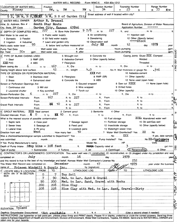
T25S, R33W, Sec. 34 NW NW NW |
Drussel, Arthur R. | 227 ft. | 95 ft. | 50 gpm. | Domestic, Livestock | Constructed | 16-Jul-1979 | Scan | |
|
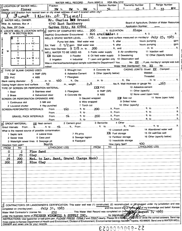
T25S, R33W, Sec. 34 NW NW NW |
Drussel, Charles | 200 ft. | 110 ft. | 2.5 gpm. | Domestic | Constructed | 31-Jul-1985 | Scan | |
|
T25S, R33W, Sec. 34 NE |
Drussel, Gary | 385 ft. | 133 ft. | Irrigation | Constructed | 26-Apr-1988 | Scan | ||
|
T25S, R33W, Sec. 34 SW SW SW SW |
Einsel, Eugene | 492 ft. | 276 ft. | 508 gpm. | Irrigation | Constructed | 12-Aug-2015 |
KOLAR |
|
|
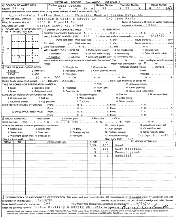
T25S, R33W, Sec. 34 C NW |
Triangle H Grain and Cattle | 313 ft. | 194 ft. | Irrigation | Plugged | 07-Feb-2006 | |||
|
T25S, R33W, Sec. 34 C NW |
Triangle H Grain and Cattle | 420 ft. | 213 ft. | Irrigation | Constructed | 10-May-2005 | |||
|
T25S, R33W, Sec. 35 NE NW SW |
Drussel, Charles | 433 ft. | 281 ft. | 100 gpm. | Domestic | Constructed | 06-Aug-2010 | ||
|
T25S, R33W, Sec. 35 NW SE NE |
Josserand, Robert | 472 ft. | 221 ft. | Irrigation | Constructed | 01-May-2011 | |||
|
T25S, R33W, Sec. 35 NW NE NE NE |
Lopez, Emilio | 435 ft. | 200 ft. | 50 gpm. | Domestic | Constructed | 01-Feb-2020 |
KOLAR |
|
|
T25S, R33W, Sec. 35 SE NW SW |
Oxy USA, Inc. | 430 ft. | 200 ft. | 100 gpm. | Oil Field Water Supply | Drussel 1 H | Constructed | 15-Dec-2010 | |
|
T25S, R33W, Sec. 35 C SW |
Triangle H Grain and Cattle | 260 ft. | 135 ft. | Irrigation | Plugged | 13-Apr-1990 | Scan | ||
|
T25S, R33W, Sec. 35 C SW |
Triangle H Grain and Cattle | 448 ft. | 139 ft. | 1500 gpm. | Irrigation | Constructed | 20-Mar-1990 | Scan | |
|
T25S, R33W, Sec. 36 NW NE SE |
Brown, Reyna | 520 ft. | 274 ft. | 50 gpm. | Domestic | Constructed | 05-Jun-2024 |
KOLAR |
|
|
T25S, R33W, Sec. 36 NE NW SE |
Drussel, Gary | 232 ft. | 220 ft. | Domestic | Plugged | 10-Aug-2010 | |||
|
T25S, R33W, Sec. 36 NE NW SE |
Drussel, Gary | 420 ft. | 220 ft. | 100 gpm. | Domestic | Constructed | 10-Aug-2010 | ||
|
T25S, R33W, Sec. 36 C S2 |
Drussel, Inc. | 410 ft. | 121 ft. | 2000 gpm. | Irrigation | Constructed | 05-Mar-1987 | Scan | |
|
T25S, R33W, Sec. 36 NE SE SW |
Drussel, O.W. | 342 ft. | 125 ft. | 60 gpm. | Domestic | Constructed | 08-Jun-1978 | Scan | |
|
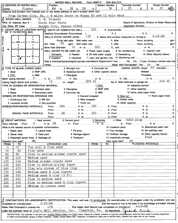
T25S, R33W, Sec. 36 NW SE SW |
Drussel, O.W. | 323 ft. | 137 ft. | 70 gpm. | Domestic | Constructed | 23-Feb-1989 | Scan | |
|
T25S, R33W, Sec. 36 NE SE NE |
Jones, Taylor | 335 ft. | 92 ft. | 1750 gpm. | Irrigation | Constructed | 28-Feb-1979 | Scan | |
|
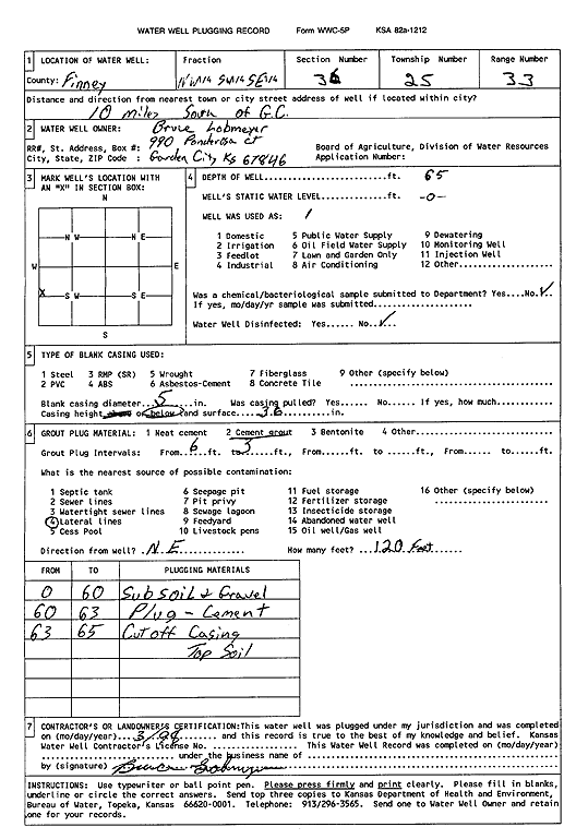
T25S, R33W, Sec. 36 NW SW SE |
Lobmeyer, Bruce | 65 ft. | Domestic | Plugged | 01-Mar-1998 | Scan | |||
|
T25S, R33W, Sec. 36 SW NE SE |
Lobmeyer, Francis | 515 ft. | 278 ft. | 40 gpm. | Domestic | Constructed | 19-Jul-2023 |
KOLAR |
|
|
T25S, R33W, Sec. 36 SW NE SE |
Lobmeyer, Francis | 287 ft. | 266 ft. | Domestic | Plugged | 18-Dec-2023 |
KOLAR |
||
|
T25S, R33W, Sec. 36 SW NE NE |
Roach, Chuck | 290 ft. | 154 ft. | Domestic | Constructed | 14-Jul-1995 | |||
|
T25S, R33W, Sec. 36 S2 NW SE NE |
Roach, Chuck | 322 ft. | 154 ft. | Domestic | Constructed | 25-Sep-1995 | |||
|
T25S, R33W, Sec. 36 NE NW NE NE |
Roach, Chuck | 334 ft. | 158 ft. | Domestic | Constructed | 24-Sep-2009 | |||
|
T25S, R33W, Sec. 36 SE NE NE NE |
Roach, Chuck | 290 ft. | 180 ft. | Domestic | Constructed | 24-Jun-1994 | |||
|
T25S, R33W, Sec. 36 SW NE SE |
Roach, Chuck | 304 ft. | 150 ft. | Domestic | Constructed | 04-Oct-1995 | |||
|
T25S, R33W, Sec. 36 SE SW SE NE |
Roach, Chuck | 290 ft. | 174 ft. | Domestic | Constructed | 09-Jul-1994 | |||
|
T25S, R33W, Sec. 36 SW NE SE |
Sage, C.O. | 260 ft. | 60 ft. | Domestic | Constructed | 22-Aug-1975 | Scan | ||
|
T25S, R34W, Sec. 2 C |
F.J.L. Ventures Group LLC | 410 ft. | 180 ft. | Domestic | Test 1 | Constructed | 06-Jul-2006 | ||
|
T25S, R34W, Sec. 2 NW NW SE NE |
Sandyhill Enterprises LLC | 571 ft. | 268 ft. | 850 gpm. | Irrigation | Constructed | 12-Aug-2020 |
KOLAR |
|
|
T25S, R34W, Sec. 3 NW SE SE |
Sandyhill Enterprises LLC | 553 ft. | 334 ft. | 600 gpm. | Irrigation | TRI 10 | Constructed | 07-May-2025 |
KOLAR |
|
T25S, R34W, Sec. 3 NE NE SW SW |
Tri-State Generation and Transmission | 540 ft. | 294 ft. | 808 gpm. | Irrigation | Constructed | 11-Apr-2018 |
KOLAR |
|
|
T25S, R34W, Sec. 3 SW SE NW NW |
Tri-State Generation and Transmission | 550 ft. | 306 ft. | 617 gpm. | Irrigation | Constructed | 08-Jul-2016 |
KOLAR |
|
|
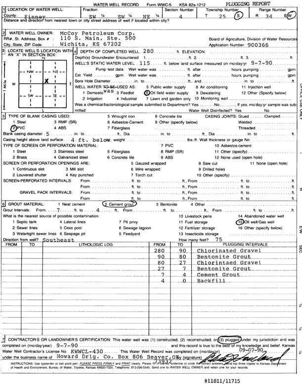
T25S, R34W, Sec. 4 SW SW NE |
McCoy Petroleum Corp. | 280 ft. | 115 ft. | Oil Field Water Supply | Plugged | 07-Sep-1990 | Scan | ||
|
T25S, R34W, Sec. 4 NW NW NE SW |
Sandyhill Enterprises LLC | 625 ft. | 258 ft. | 800 gpm. | Irrigation | Constructed | 09-Dec-2020 |
KOLAR |
|
|
T25S, R34W, Sec. 4 NE NE SW NW |
Sandyhill Enterprises LLC | 651 ft. | 271 ft. | 900 gpm. | Irrigation | Constructed | 07-Oct-2020 |
KOLAR |
|
|
T25S, R34W, Sec. 4 NW SW SE SW |
Sandyhill Enterprises LLC | 637 ft. | 330 ft. | 650 gpm. | Irrigation | Constructed | 15-Jul-2021 |
KOLAR |
|
|
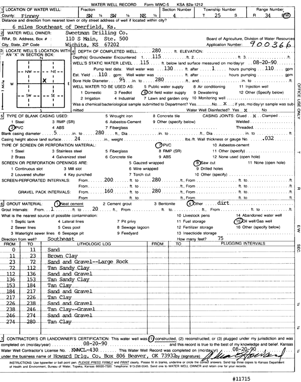
T25S, R34W, Sec. 4 SW SW NE |
Sweetman Drilling Co. | 280 ft. | 115 ft. | 110 gpm. | Oil Field Water Supply | Constructed | 20-Aug-1990 | Scan | |
|
T25S, R34W, Sec. 4 C NE |
Tri-State Generation | 365 ft. | 270 ft. | Irrigation | Plugged | 09-Nov-2012 | |||
|
T25S, R34W, Sec. 4 NW NW NE |
Tri-State Generation | 460 ft. | 269 ft. | Irrigation | Test 2 | Constructed | 02-Nov-2012 | ||
|
T25S, R34W, Sec. 4 NE NE NW SE |
Tri-State Generation and Transmission | 550 ft. | 308 ft. | 719 gpm. | Irrigation | Constructed | 13-Apr-2018 |
KOLAR |
|
|
T25S, R34W, Sec. 5 NW NW NE |
Duane Koster Farms | 420 ft. | Domestic | Constructed | 06-Jul-2010 | ||||
|
T25S, R34W, Sec. 5 NE SW SW SE |
Wheatland Electric Cooperative | 409 ft. | 284 ft. | 352 gpm. | Irrigation | Constructed | 05-Jun-2015 |
KOLAR |
|
|
T25S, R34W, Sec. 5 NW |
Wheatland Electric Cooperative | 295 ft. | 269 ft. | Irrigation | Plugged | 01-May-2013 | |||
|
T25S, R34W, Sec. 5 NE SW NW |
Wheatland Electric Cooperative | 420 ft. | 261 ft. | Irrigation | Constructed | 09-May-2013 | |||
|
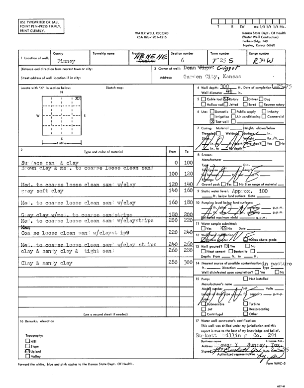
T25S, R34W, Sec. 6 NE NE NE |
Gigot, Dean | 300 ft. | 100 ft. | Test hole/well | Constructed | 25-Jan-1975 | Scan | ||
|
T25S, R34W, Sec. 6 NE SE SW |
Koster, Duane | 350 ft. | 192 ft. | Irrigation | Constructed | 19-Dec-2003 | Scan | ||
|
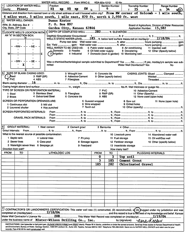
T25S, R34W, Sec. 6 E2 E2 SW |
Koster, Duane | 282 ft. | 185 ft. | Irrigation | Plugged | 18-Feb-2004 | Scan | ||
| View page: < Prev || 91 || 92 || 93 || 94 || 95 || 96 || 97 || 98 || 99 || 100 || Next > | |||||||||