Select location of well to view details.
Click on column heading to sort.
|
|
|
County: Ford Select location of well to view details. Click on column heading to sort. |
|
|
|
| View page: < Prev || 31 || 32 || 33 || 34 || 35 || 36 || 37 || 38 || 39 || 40 || Next > | |||||||||
| T-R-S | Owner | Well Depth Ascend. Desc. |
Static Water Level Ascend. Desc. |
Est. Yield Ascend. Desc. |
Well Use | Other ID | Action Taken | Completion Date Ascend. Desc. |
Scan? |
|
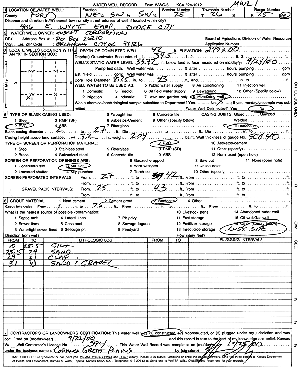
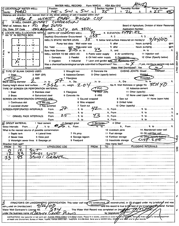
T26S, R25W, Sec. 25 NE SW SW |
Musket Corp. | 42 ft. | 33.72 ft. | Monitoring well/observation/piezometer | MW 21 | Constructed | 22-Sep-2000 | Scan | |
|
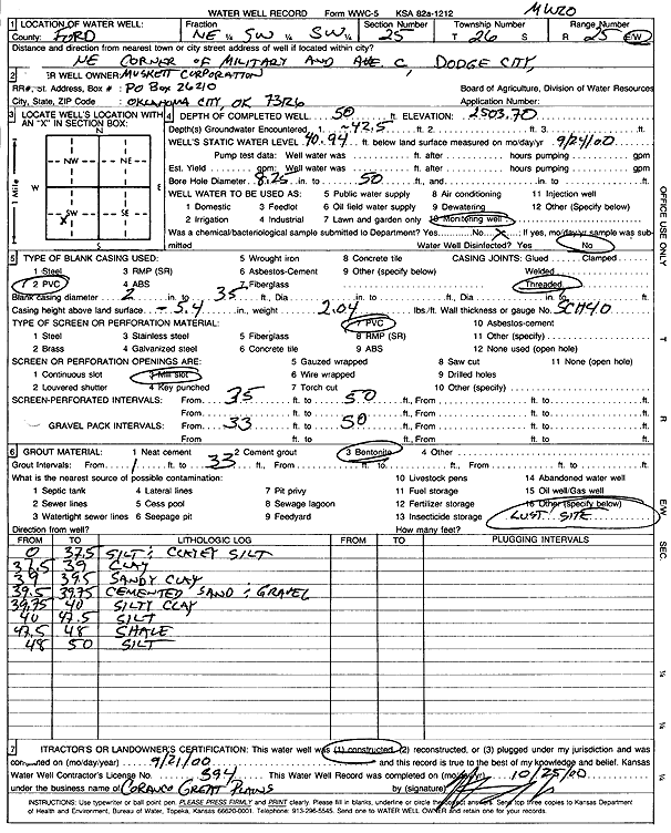
T26S, R25W, Sec. 25 NE SW SW |
Musket Corp. | 50 ft. | 40.94 ft. | Monitoring well/observation/piezometer | MW 20 | Constructed | 21-Sep-2000 | Scan | |
|
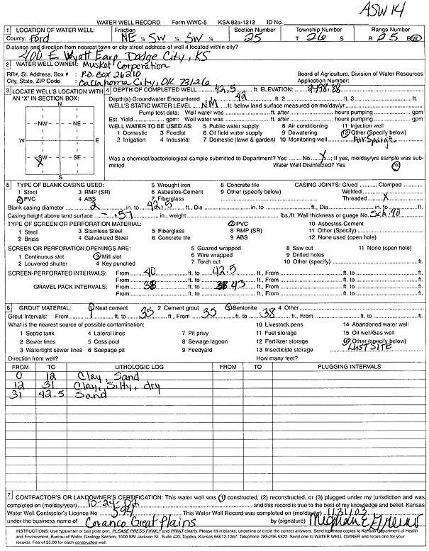
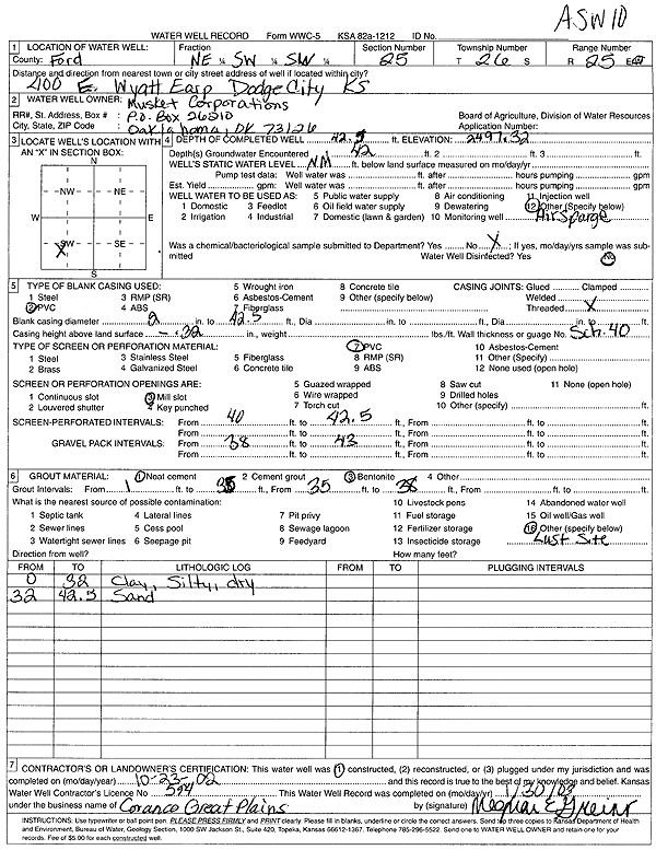
T26S, R25W, Sec. 25 NE SW SW |
Musket Corp. | 42.5 ft. | Environmental Remediation, Air Sparge | ASW 14 | Constructed | 24-Oct-2002 | Scan | ||
|
T26S, R25W, Sec. 25 NE SW SW |
Musket Corp. | 45 ft. | 38 ft. | Environmental Remediation, Air Sparge | ASW 4 | Constructed | 05-Feb-2002 | Scan | |
|
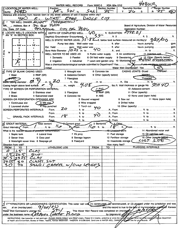
T26S, R25W, Sec. 25 NE SW SW |
Musket Corp. | 40 ft. | 35.82 ft. | Environmental Remediation, Soil Vapor Extraction | VOBW 3 | Constructed | 20-Sep-2000 | Scan | |
|
T26S, R25W, Sec. 25 NE SW SW |
Musket Corp. | 42 ft. | 35 ft. | Monitoring well/observation/piezometer | MW 22 | Constructed | 22-Sep-2000 | Scan | |
|
T26S, R25W, Sec. 25 NE SW SW |
Musket Corp. | 39.15 ft. | Environmental Remediation, Soil Vapor Extraction | VOBW 1 | Plugged | 29-Apr-2010 | |||
|
T26S, R25W, Sec. 25 NE SW SW |
Musket Corp. | 41.4 ft. | 39.56 ft. | Environmental Remediation, Soil Vapor Extraction | VOBW 3 | Plugged | 29-Apr-2010 | ||
|
T26S, R25W, Sec. 25 NE SW SW |
Musket Corp. | 40 ft. | Environmental Remediation, Soil Vapor Extraction | VEW 1 | Plugged | 29-Apr-2010 | |||
|
T26S, R25W, Sec. 25 NE SW SW |
Musket Corp. | 39.7 ft. | Environmental Remediation, Soil Vapor Extraction | VEW 7 | Plugged | 11-Mar-2008 | |||
|
T26S, R25W, Sec. 25 NE SW SW |
Musket Corp. | 49.3 ft. | 42.8 ft. | Monitoring well/observation/piezometer | MW 32 | Plugged | 11-Mar-2008 | ||
|
T26S, R25W, Sec. 25 NE SW SW |
Musket Corp. | 40.92 ft. | Environmental Remediation, Air Sparge | ASW 14 | Plugged | 11-Mar-2008 | |||
|
T26S, R25W, Sec. 25 NE SW SW |
Musket Corp. | 42.43 ft. | Environmental Remediation, Air Sparge | ASW 12 | Plugged | 11-Mar-2008 | |||
|
T26S, R25W, Sec. 25 NE SW SW |
Musket Corp. | 42.25 ft. | 41.33 ft. | Environmental Remediation, Air Sparge | ASW 10 | Plugged | 11-Mar-2008 | ||
|
T26S, R25W, Sec. 25 NW SW SW |
Musket Corp. | 46.5 ft. | Environmental Remediation, Air Sparge | ASW 15 | Constructed | 28-Jul-2008 | |||
|
T26S, R25W, Sec. 25 NE SW SW |
Musket Corp. | 42.5 ft. | Environmental Remediation, Air Sparge | ASW 10 | Constructed | 23-Oct-2002 | Scan | ||
|
T26S, R25W, Sec. 25 SE SW SW |
Safety-Kleen Systems, Inc. | 69.9 ft. | Monitoring well/observation/piezometer | MW 1D | Plugged | 24-Nov-2025 |
KOLAR |
||
|
T26S, R25W, Sec. 25 SE SW SW |
Safety-Kleen Systems, Inc. | 30 ft. | Monitoring well/observation/piezometer | RFI 2 | Plugged | 24-Nov-2025 |
KOLAR |
||
|
T26S, R25W, Sec. 25 SE SW SW |
Safety-Kleen Systems, Inc. | 28 ft. | Monitoring well/observation/piezometer | RFI 4 | Plugged | 24-Nov-2025 |
KOLAR |
||
|
T26S, R25W, Sec. 25 SE SW SW |
Safety-Kleen Systems, Inc. | 28 ft. | Monitoring well/observation/piezometer | RFI 1 | Plugged | 24-Nov-2025 |
KOLAR |
||
|
T26S, R25W, Sec. 25 SE SW SW |
Safety-Kleen Systems, Inc. | 53.53 ft. | Monitoring well/observation/piezometer | MW 3D | Plugged | 24-Nov-2025 |
KOLAR |
||
|
T26S, R25W, Sec. 25 SE SW SW |
Safety-Kleen Systems, Inc. | 32 ft. | Monitoring well/observation/piezometer | RFI 5 | Plugged | 24-Nov-2025 |
KOLAR |
||
|
T26S, R25W, Sec. 25 SE SW SW |
Safety-Kleen Systems, Inc. | 29 ft. | Monitoring well/observation/piezometer | RFI 3 | Plugged | 24-Nov-2025 |
KOLAR |
||
|
T26S, R25W, Sec. 25 SE SW SW |
Safety-Kleen Systems, Inc. | 71.85 ft. | Monitoring well/observation/piezometer | MW 2D | Plugged | 25-Nov-2025 |
KOLAR |
||
|
T26S, R25W, Sec. 25 SE SE SW SW |
Safety-Kleen, Inc. | 70 ft. | 51 ft. | Monitoring well/observation/piezometer | MW 1 D | Constructed | 15-Jul-2016 | ||
|
T26S, R25W, Sec. 25 SW SE SW SW |
Safety-Kleen, Inc. | 29 ft. | Monitoring well/observation/piezometer | RFI 3 | Constructed | 17-Jul-2016 | |||
|
T26S, R25W, Sec. 25 SW SE SW SW |
Safety-Kleen, Inc. | 28 ft. | Monitoring well/observation/piezometer | RFI 4 | Constructed | 17-Jul-2016 | |||
|
T26S, R25W, Sec. 25 SW SE SW SW |
Safety-Kleen, Inc. | 30 ft. | Monitoring well/observation/piezometer | RFI 2 | Constructed | 16-Jul-2016 | |||
|
T26S, R25W, Sec. 25 SW SE SW SW |
Safety-Kleen, Inc. | 32 ft. | Monitoring well/observation/piezometer | RFI 5 | Constructed | 18-Jul-2016 | |||
|
T26S, R25W, Sec. 25 SW SE SW SW |
Safety-Kleen, Inc. | 70 ft. | 53 ft. | Monitoring well/observation/piezometer | MW 3 D | Constructed | 16-Jul-2016 | ||
|
T26S, R25W, Sec. 25 SW SE SW SW |
Safety-Kleen, Inc. | 28 ft. | Monitoring well/observation/piezometer | RFI 1 | Constructed | 16-Jul-2016 | |||
|
T26S, R25W, Sec. 25 NW SE SW SW |
Safety-Kleen, Inc. | 72 ft. | 57 ft. | Monitoring well/observation/piezometer | MW 2 D | Constructed | 14-Jul-2016 | ||
|
T26S, R25W, Sec. 25 SW NE NE |
Sundance Apartments | 240 ft. | 147 ft. | 50 gpm. | Irrigation | Constructed | 25-Jun-2002 | Scan | |
|
T26S, R25W, Sec. 25 SW SW SW |
Taylor and Assoc. | 35 ft. | 28 ft. | 11 gpm. | Monitoring well/observation/piezometer | Constructed | 29-Jul-1988 | ||
|
T26S, R25W, Sec. 25 SW SW SW SW |
Winfield Solutions, LLC | 62 ft. | 51 ft. | Monitoring well/observation/piezometer | WSMW 4 | Constructed | 09-Jul-2014 | ||
|
T26S, R25W, Sec. 25 SW SW SW SW |
Winfield Solutions, LLC | 63 ft. | 51 ft. | Monitoring well/observation/piezometer | WSMW 3 | Constructed | 09-Jul-2014 | ||
|
T26S, R25W, Sec. 25 SW SW SW SW |
Winfield Solutions, LLC | 63 ft. | 49 ft. | Monitoring well/observation/piezometer | WSMW 1 | Constructed | 08-Jul-2014 | ||
|
T26S, R25W, Sec. 25 SW SW SW SW |
Winfield Solutions, LLC | 57 ft. | 49 ft. | Monitoring well/observation/piezometer | WSMW 2 | Constructed | 08-Jul-2014 | ||
|
T26S, R25W, Sec. 26 SE SE SW |
Centel Corporation | 25 ft. | 18.5 ft. | Monitoring well/observation/piezometer | MW 1 | Constructed | 12-Jun-1990 | ||
|
T26S, R25W, Sec. 26 SE SE SW |
Centel Corporation | 25 ft. | 16.5 ft. | Monitoring well/observation/piezometer | MW 4 | Constructed | 12-Jun-1990 | ||
|
T26S, R25W, Sec. 26 SE SE SW |
Centel Corporation | 25 ft. | 17.9 ft. | Monitoring well/observation/piezometer | MW 3 | Constructed | 12-Jun-1990 | ||
|
T26S, R25W, Sec. 26 SE SE SW |
Centel Corporation | 25 ft. | 18.5 ft. | Monitoring well/observation/piezometer | MW 2 | Constructed | 12-Jun-1990 | ||
|
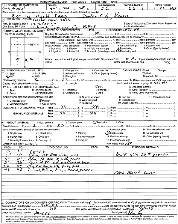
T26S, R25W, Sec. 26 NE SE SW |
Coastal Mart 2536 | 55 ft. | 43.75 ft. | Monitoring well/observation/piezometer | MW 1 R | Constructed | 20-May-2008 | ||
|
T26S, R25W, Sec. 26 NE SE SW |
Coastal Mart 2536 | 56 ft. | 46.94 ft. | Monitoring well/observation/piezometer | MW 6 R | Constructed | 21-May-2008 | ||
|
T26S, R25W, Sec. 26 NE SE SW |
Coastal Mart 2536 | 55 ft. | 43.67 ft. | Monitoring well/observation/piezometer | MW 2 R | Constructed | 20-May-2008 | ||
|
T26S, R25W, Sec. 26 NW SW SE |
Coastal Mart 2536 | 48 ft. | Monitoring well/observation/piezometer | Constructed | 10-Sep-2003 | Scan | |||
|
T26S, R25W, Sec. 26 NE SE SW |
Coastal Mart 2536 | 41.7 ft. | Monitoring well/observation/piezometer | MW 1 | Plugged | 22-May-2008 | |||
|
T26S, R25W, Sec. 26 NE SE SW |
Coastal Mart Inc | 54.43 ft. | 43.29 ft. | Monitoring well/observation/piezometer | MW 2 R | Plugged | 05-Feb-2009 | ||
|
T26S, R25W, Sec. 26 NE SE SW |
Coastal Mart Inc | 54.55 ft. | 43.41 ft. | Monitoring well/observation/piezometer | MW 1 R | Plugged | 05-Feb-2009 | ||
|
T26S, R25W, Sec. 26 NE SE SW |
Coastal Mart Inc | 45.55 ft. | 44.16 ft. | Monitoring well/observation/piezometer | MW 3 | Plugged | 05-Feb-2009 | ||
| View page: < Prev || 31 || 32 || 33 || 34 || 35 || 36 || 37 || 38 || 39 || 40 || Next > | |||||||||