Select location of well to view details.
Click on column heading to sort.
|
|
|
County: Ford Select location of well to view details. Click on column heading to sort. |
|
|
|
| View page: < Prev || 51 || 52 || 53 || 54 || 55 || 56 || 57 || 58 || 59 || 60 || Next > | |||||||||
| T-R-S | Owner | Well Depth Ascend. Desc. |
Static Water Level Ascend. Desc. |
Est. Yield Ascend. Desc. |
Well Use | Other ID | Action Taken | Completion Date Ascend. Desc. |
Scan? |
|
T26S, R26W, Sec. 27 NW NW NW |
CCRG | 15 ft. | 15 ft. | Monitoring well/observation/piezometer | MW 3 S | Plugged | 09-Nov-1992 | ||
|
T26S, R26W, Sec. 27 NW NW NW |
CCRG | 20 ft. | 16 ft. | Monitoring well/observation/piezometer | MW 6 | Plugged | 09-Nov-1992 | ||
|
T26S, R26W, Sec. 27 NW NW NW |
CCRG | 15 ft. | 15 ft. | Monitoring well/observation/piezometer | MW 2 D | Plugged | 09-Nov-1992 | ||
|
T26S, R26W, Sec. 27 NW NW NW |
CCRG | 20 ft. | 18 ft. | Monitoring well/observation/piezometer | MW 5 | Plugged | 09-Nov-1992 | ||
|
T26S, R26W, Sec. 27 NW NW NW |
CCRG | 15 ft. | 15 ft. | Monitoring well/observation/piezometer | MW 25 | Plugged | 09-Nov-1992 | ||
|
T26S, R26W, Sec. 27 NW NW NW |
CCRG | 20 ft. | 15 ft. | Monitoring well/observation/piezometer | MW 7 | Plugged | 09-Nov-1992 | Scan | |
|
T26S, R26W, Sec. 27 NW NW NW |
CCRG | 20 ft. | 18 ft. | Monitoring well/observation/piezometer | MW 3 D | Plugged | 09-Nov-1992 | ||
|
T26S, R26W, Sec. 27 NW NW NW |
CCRG | 15 ft. | 15 ft. | Monitoring well/observation/piezometer | MW 15 | Plugged | 09-Nov-1992 | ||
|
T26S, R26W, Sec. 27 NW NW NW |
CCRG | 14 ft. | 14 ft. | Monitoring well/observation/piezometer | MW 4 S | Plugged | 01-Dec-1992 | ||
|
T26S, R26W, Sec. 27 NW NW NW |
CCRG | 20 ft. | 15 ft. | Monitoring well/observation/piezometer | MW 1 D | Plugged | 09-Nov-1992 | ||
|
T26S, R26W, Sec. 27 SE SE NW |
Hessman, Steve | 17.5 ft. | Domestic | Plugged | 06-Feb-1992 | ||||
|
T26S, R26W, Sec. 27 NE |
Hessman, Steve | 190 ft. | 33 ft. | 1500 gpm. | Irrigation | Constructed | 10-Aug-1984 | ||
|
T26S, R26W, Sec. 27 SE SE NW |
Hessman, Steve | 50 ft. | 17.5 ft. | Domestic | Constructed | 06-Feb-1992 | |||
|
T26S, R26W, Sec. 28 NW NW NW |
Ackeman, Steve | 340 ft. | 156 ft. | 40 gpm. | Domestic | Constructed | 05-Jul-1990 | ||
|
T26S, R26W, Sec. 28 C NE SW |
Getz, Vern | 148 ft. | 63 ft. | Domestic | Constructed | 31-May-1979 | |||
|
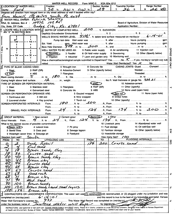
T26S, R26W, Sec. 28 SE NW NW |
Stanley, Patrick | 200 ft. | 51.5 ft. | Domestic | Constructed | 14-Jun-2001 | Scan | ||
|
T26S, R26W, Sec. 29 NW SE SW |
Doll, Loren | 216 ft. | 40 ft. | Test hole/well | Constructed | 21-Aug-1971 | Scan | ||
|
T26S, R26W, Sec. 29 SE NW NE |
Feldt, Norbert | 229 ft. | 39 ft. | 480 gpm. | Domestic | Constructed | 19-Jan-1976 | ||
|
T26S, R26W, Sec. 29 SW SE NE |
Felt, Norbat | 245 ft. | Test hole/well | Test 1 | Constructed | 15-Apr-1974 | Scan | ||
|
T26S, R26W, Sec. 30 NW NE SE |
Goetz Farms, Inc | 224 ft. | 105 ft. | Irrigation | Constructed | 03-Jul-2014 | |||
|
T26S, R26W, Sec. 31 NE NE NW |
Getz, Vern | 223 ft. | 62 ft. | Domestic, Livestock | Constructed | 20-Apr-1979 | |||
|
T26S, R26W, Sec. 31 SW SW SW |
Haughawout, Anabelle | 200 ft. | 114 ft. | Domestic | Constructed | 05-Oct-1995 | |||
|
T26S, R26W, Sec. 31 SE SW SE |
Miller, Duane | 120 ft. | 85 ft. | Domestic | Constructed | 20-Mar-1979 | |||
|
T26S, R26W, Sec. 31 NW SW SW |
Miller, Duane | 175 ft. | 74 ft. | 1451 gpm. | Irrigation | Constructed | 04-Jan-1977 | ||
|
T26S, R26W, Sec. 32 SE |
Circle D Farms LLC | 125 ft. | 117 ft. | Irrigation | Plugged | 15-Mar-2013 | |||
|
T26S, R26W, Sec. 32 NW |
Circle D Farms LLC | 135 ft. | 99 ft. | Irrigation | Plugged | 15-Mar-2013 | |||
|
T26S, R26W, Sec. 32 SW SW NW |
Dirks, Eldon | 160 ft. | 100 ft. | Irrigation | Constructed | 02-Jun-2010 | |||
|
T26S, R26W, Sec. 32 NC SE |
Dirks, Eldon and Linda | 160 ft. | 105 ft. | 880 gpm. | Irrigation | Constructed | 20-May-2005 | ||
|
T26S, R26W, Sec. 32 SE NW NW |
Doll, Loren | 138 ft. | Test hole/well | 2 | Constructed | 09-Sep-1967 | Scan | ||
|
T26S, R26W, Sec. 33 NW |
Circle D Farms LLC | 145 ft. | 105 ft. | Irrigation | Plugged | 15-Mar-2013 | |||
|
T26S, R26W, Sec. 33 NW NW NW |
Dirks, Eldon | 203 ft. | 79 ft. | 50 gpm. | Domestic | Constructed | 25-Apr-2002 | Scan | |
|
T26S, R26W, Sec. 33 SE SE NW |
Dirks, Eldon and Linda | 182 ft. | 102 ft. | Irrigation | Constructed | 03-May-2011 | |||
|
T26S, R26W, Sec. 33 SE NW SW |
Hemink Farms, LTD | 210 ft. | 132 ft. | 400 gpm. | Irrigation | Constructed | 23-Feb-2026 |
KOLAR |
|
|
T26S, R26W, Sec. 33 NW NW SW |
Schiffner, Albert | 165 ft. | 110 ft. | 50 gpm. | Domestic | Constructed | 10-Feb-2002 | ||
|
T26S, R26W, Sec. 33 NC SW |
Schiffner, Albert | 183 ft. | 69 ft. | 2000 gpm. | Irrigation | Constructed | 02-Feb-1977 | ||
|
T26S, R26W, Sec. 34 SE SE SW |
Black, Wesley | 144 ft. | 114 ft. | Domestic | Plugged | 22-Feb-2007 | |||
|
T26S, R26W, Sec. 34 SE SE SW |
Black, Wesley | 165 ft. | 114 ft. | Domestic | Constructed | 22-Feb-2007 | |||
|
T26S, R26W, Sec. 34 NW SE SW |
Black, Wesley | 5.5 ft. | Domestic | Plugged | 15-May-1997 | ||||
|
T26S, R26W, Sec. 34 SE SE SE |
Goetz Farms | 145 ft. | 80 ft. | 40 gpm. | Domestic | Constructed | 02-May-1995 | ||
|
T26S, R26W, Sec. 34 SW SW NW |
Stanley, Rex | 140 ft. | 62 ft. | 50 gpm. | Domestic | Constructed | 08-Oct-1986 | ||
|
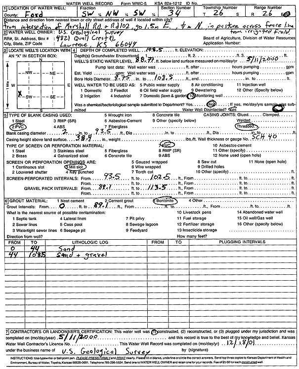
T26S, R26W, Sec. 34 SW NW SW |
U.S. Geological Survey | 108.5 ft. | 88.77 ft. | Monitoring well/observation/piezometer | Constructed | 11-May-2000 | Scan | ||
|
T26S, R26W, Sec. 34 SW NW SW |
U.S. Geological Survey | 108.5 ft. | 88.77 ft. | Monitoring well/observation/piezometer | Constructed | 11-May-2000 | Scan | ||
|
T26S, R26W, Sec. 35 SE NE SE |
Hampton, Monte | 166 ft. | 113 ft. | Domestic | Constructed | 14-Jun-1993 | |||
|
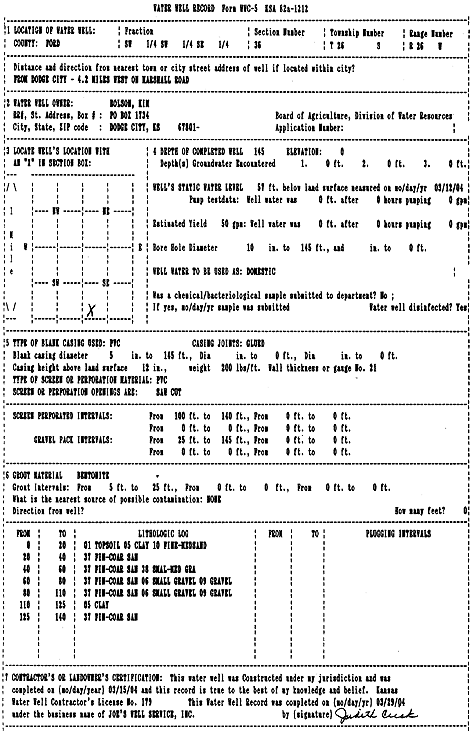
T26S, R26W, Sec. 36 SW SW SE |
Bolson, Kim | 145 ft. | 57 ft. | 50 gpm. | Domestic | Constructed | 15-Mar-2004 | Scan | |
|
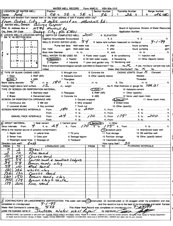
T26S, R26W, Sec. 36 NE SE SE |
Gepner, George | 200 ft. | 54 ft. | Domestic | Constructed | 01-Sep-1999 | Scan | ||
|
T26S, R26W, Sec. 36 SE SE NE |
Shumard, Don | 175 ft. | 14 ft. | 1000 gpm. | Irrigation | Constructed | 21-Feb-1977 | ||
|
T26S, R26W, Sec. 36 NW SE NW |
Shumard, Donald | 167 ft. | 31 ft. | 525 gpm. | Irrigation | Constructed | 10-Jun-1993 | ||
|
T26S, R26W, Sec. 36 SW SW SE |
Shumard, Donald A. and Donna Dee | 140 ft. | 54 ft. | Irrigation | Constructed | 20-Aug-2001 | Scan | ||
|
T26S, R26W, Sec. 36 SW SW SW |
Shumard, Johnny | 150 ft. | 15 ft. | 24 gpm. | Domestic | Constructed | 25-Aug-1979 | ||
|
T26S, R26W, Sec. 36 NE SE SE |
Sughroue, Sam | 200 ft. | 90 ft. | Domestic | Constructed | 15-May-2023 |
KOLAR |
||
| View page: < Prev || 51 || 52 || 53 || 54 || 55 || 56 || 57 || 58 || 59 || 60 || Next > | |||||||||