Select location of well to view details.
Click on column heading to sort.
|
|
|
County: Ford Select location of well to view details. Click on column heading to sort. |
|
|
|
| View page: < Prev || 71 || 72 || 73 || 74 || 75 || 76 || 77 || 78 || 79 || 80 || Next > | |||||||||
| T-R-S | Owner | Well Depth Ascend. Desc. |
Static Water Level Ascend. Desc. |
Est. Yield Ascend. Desc. |
Well Use | Other ID | Action Taken | Completion Date Ascend. Desc. |
Scan? |
|
T28S, R21W, Sec. 7 NE NE NE SW |
Stout, Joe | 100 ft. | 55 ft. | 50 gpm. | Domestic | Constructed | 04-Nov-2009 | ||
|
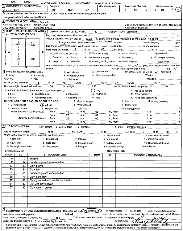
T28S, R21W, Sec. 8 SE NW NE |
Demuth, Mike | 89 ft. | 47.23 ft. | Domestic, Livestock | Constructed | 18-Dec-2003 | Scan | ||
|
T28S, R21W, Sec. 8 NE SE SE |
Vincent Oil Corp. | 87 ft. | 53 ft. | Oil Field Water Supply | Constructed | 27-Dec-2015 | |||
|
T28S, R21W, Sec. 9 C NE |
Austin Farms | 80 ft. | 40 ft. | 750 gpm. | Irrigation | Constructed | 09-Mar-1975 | ||
|
T28S, R21W, Sec. 9 SW SE SE |
Austin Farms | 81 ft. | 40 ft. | 800 gpm. | Irrigation | Constructed | 28-Sep-1981 | ||
|
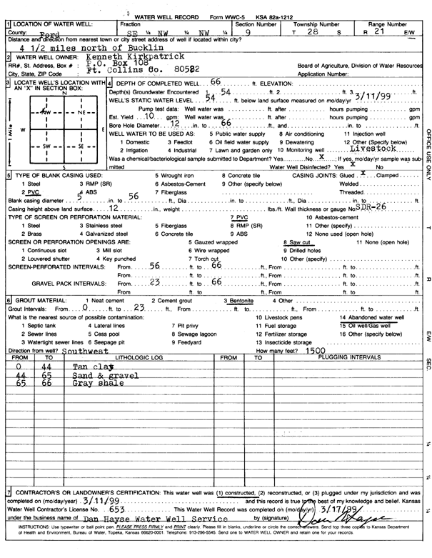
T28S, R21W, Sec. 9 SE NW NW |
Kirkpatrick, Kenneth | 66 ft. | 54 ft. | 10 gpm. | Domestic, Livestock | Constructed | 11-Mar-1999 | Scan | |
|
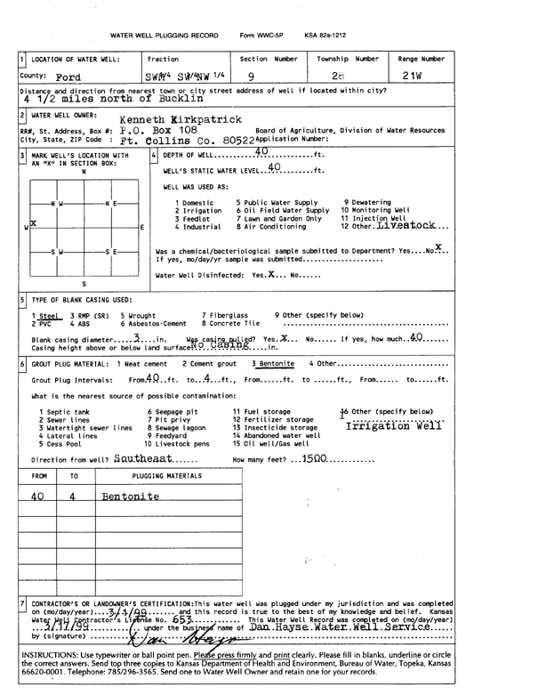
T28S, R21W, Sec. 9 SW SW NW |
Kirkpatrick, Kenneth | 40 ft. | 40 ft. | Domestic, Livestock | Plugged | 01-Mar-1999 | Scan | ||
|
T28S, R21W, Sec. 9 C SW |
Konda, Leo | 97 ft. | 40 ft. | 1000 gpm. | Irrigation | Constructed | 03-Mar-1975 | ||
|
T28S, R21W, Sec. 9 SW SE SW NE |
Stimpert, Roger | 100 ft. | 65 ft. | 15 gpm. | Domestic, Livestock | Constructed | 03-Sep-2016 | ||
|
T28S, R21W, Sec. 10 N2 SE NE |
Slawson Drilling Co. | 65 ft. | 40 ft. | Oil Field Water Supply | Constructed | 01-Nov-1980 | |||
|
T28S, R21W, Sec. 10 C NE NE |
Xplore Drilling Co. | 60 ft. | 23 ft. | Oil Field Water Supply | Constructed | 29-Aug-1978 | |||
|
T28S, R21W, Sec. 11 NE SW SW |
Kirkpatrick, Arden | 82 ft. | 56 ft. | Irrigation | Plugged | 02-Oct-2010 | |||
|
T28S, R21W, Sec. 11 C S2 N2 |
Pickrell Drilling Co. | 65 ft. | 40 ft. | Oil Field Water Supply | Constructed | 29-Sep-1980 | |||
|
T28S, R21W, Sec. 11 C SW NW |
Pickrell Drilling Co. | 75 ft. | 42 ft. | 100 gpm. | Oil Field Water Supply | Constructed | 15-Aug-1979 | ||
|
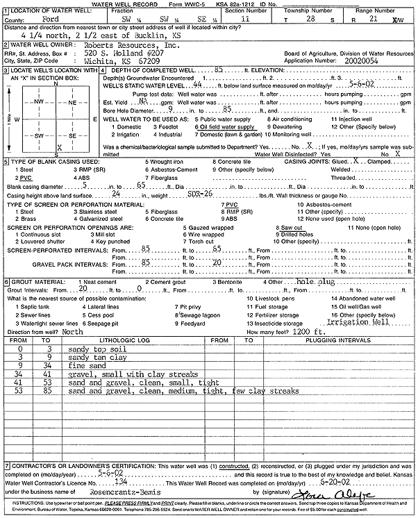
T28S, R21W, Sec. 11 SW SW SE |
Roberts Resources Inc | 85 ft. | 44 ft. | Oil Field Water Supply | Constructed | 06-May-2002 | Scan | ||
|
T28S, R21W, Sec. 12 NE |
McFadden, CJ | 82 ft. | 55 ft. | Domestic, Livestock | Constructed | 28-Oct-2015 | |||
|
T28S, R21W, Sec. 12 SE NE SW |
McFadden, Luke | 104 ft. | 58 ft. | Domestic, Livestock | Constructed | 30-Aug-2018 | |||
|
T28S, R21W, Sec. 12 SW NE SE |
Pickrell Drilling Co. | 106 ft. | 46 ft. | Oil Field Water Supply | Constructed | 17-Jan-1978 | |||
|
T28S, R21W, Sec. 12 SE SE NW |
Tilley, Tony | 28 ft. | 10 ft. | Domestic | Constructed | 12-Jul-1993 | |||
|
T28S, R21W, Sec. 13 SW SW SW |
Aldebaron Drilling Co | 132 ft. | 92 ft. | 70 gpm. | Oil Field Water Supply | Brensing 1 | Constructed | 25-Aug-1982 | |
|
T28S, R21W, Sec. 13 SW SW NW |
Wells Energy | 120 ft. | 70 ft. | 100 gpm. | Oil Field Water Supply | Brensing 2 | Constructed | 09-Sep-1983 | |
|
T28S, R21W, Sec. 13 NW NW NE |
Zenger, Cory | 105 ft. | 60 ft. | Domestic, Livestock | Constructed | 05-Feb-2024 |
KOLAR |
||
|
T28S, R21W, Sec. 14 NW NW NE |
H-30 Drilling, Inc. | 100 ft. | 70 ft. | 60 gpm. | Oil Field Water Supply | Constructed | 22-Oct-1980 | ||
|
T28S, R21W, Sec. 14 NE NW NE |
Slawson Drilling Co. | 110 ft. | 52 ft. | Oil Field Water Supply | Constructed | 24-Mar-1979 | |||
|
T28S, R21W, Sec. 14 NE NW NE |
Slawson Drilling Co. | 110 ft. | 52 ft. | Oil Field Water Supply | Constructed | 27-Feb-1979 | |||
|
T28S, R21W, Sec. 14 E2 NE SW |
Slawson Drilling Co. | 130 ft. | 65 ft. | Oil Field Water Supply | Constructed | 28-Jan-1981 | |||
|
T28S, R21W, Sec. 14 NW NE SW |
TXO Production Co | 140 ft. | 85 ft. | 80 gpm. | Oil Field Water Supply | Mann B 3 | Constructed | 19-Sep-1985 | |
|
T28S, R21W, Sec. 15 NE NE NE |
H-30 Drilling, Inc. | 80 ft. | 42 ft. | 100 gpm. | Oil Field Water Supply | Davis J 1 | Constructed | 19-Oct-1981 | |
|
T28S, R21W, Sec. 15 NW SE SE |
Janssen, John | 119 ft. | 74 ft. | 1100 gpm. | Irrigation | Constructed | 18-Jun-2007 | ||
|
T28S, R21W, Sec. 15 NW SE SE |
Janssen, John | 107 ft. | 74 ft. | Domestic, Livestock | Reconstructed | 18-Jun-2007 | |||
|
T28S, R21W, Sec. 16 SE SE SW |
Davis, Thayne | 125 ft. | 85 ft. | Oil Field Water Supply | Plugged | 23-Oct-1984 | |||
|
T28S, R21W, Sec. 16 SW NW |
Konda, Leo | 70 ft. | 35 ft. | 600 gpm. | Irrigation | Constructed | 10-Apr-1975 | ||
|
T28S, R21W, Sec. 16 NE NE SW |
Murfin Drilling Co/Austin, Roy | 120 ft. | 52 ft. | Oil Field Water Supply | Plugged | 15-Oct-1992 | |||
|
T28S, R21W, Sec. 16 NE NE SW |
Murfin Drilling Co/Austin, Roy | 120 ft. | 52 ft. | Oil Field Water Supply | Constructed | 30-Sep-1992 | |||
|
T28S, R21W, Sec. 16 SE SE SW |
Red Tiger Drilling/Davis Trust | 125 ft. | 80 ft. | 60 gpm. | Oil Field Water Supply | Davis Trust 1-16 | Constructed | 01-Oct-1984 | |
|
T28S, R21W, Sec. 16 C NE |
Ringwald, John | 109 ft. | 44 ft. | Irrigation | Constructed | 03-May-1976 | |||
|
T28S, R21W, Sec. 16 SW SE NE |
Vincent Oil Corp. | 100 ft. | 64 ft. | Oil Field Water Supply | Plugged | 13-Apr-2017 | |||
|
T28S, R21W, Sec. 16 SW SE NE |
Vincent Oil Corp. | 100 ft. | 64 ft. | Oil Field Water Supply | Ringwald 1-16 | Constructed | 13-Apr-2017 | ||
|
T28S, R21W, Sec. 17 NW SW NW |
Price, Marvin | 115 ft. | 50 ft. | Irrigation | Constructed | 22-Feb-1977 | |||
|
T28S, R21W, Sec. 17 C SW |
Price, Marvin | 149 ft. | 45 ft. | Irrigation | Constructed | 22-Dec-1977 | |||
|
T28S, R21W, Sec. 18 NE NE SE |
Sellard Farms | 120 ft. | 50 ft. | Domestic | Constructed | 08-Nov-2010 | |||
|
T28S, R21W, Sec. 18 SE SE NW |
Vincent Oil Corp. | 119 ft. | 65 ft. | Oil Field Water Supply | Demuth 1-18 | Constructed | 05-Jul-2017 | ||
|
T28S, R21W, Sec. 19 NE SE SE |
Ellis, Gilbert | 170 ft. | 98 ft. | Domestic, Livestock | Constructed | 02-Dec-2010 | |||
|
T28S, R21W, Sec. 20 SE SW SE |
Trager, Fern | 120 ft. | 80 ft. | 25 gpm. | Domestic | Constructed | 26-Mar-1981 | ||
|
T28S, R21W, Sec. 20 SW SW SE |
Trager, Mrs. Ralph | 120 ft. | 87 ft. | 25 gpm. | Domestic | Constructed | 01-Oct-1980 | ||
|
T28S, R21W, Sec. 20 SW SW SE |
Trager, Mrs. Ralph | 120 ft. | 87 ft. | 25 gpm. | Domestic | Constructed | 01-Oct-1980 | ||
|
T28S, R21W, Sec. 21 SW NE NW |
Kirkpatrick, Keith | 135 ft. | 80 ft. | 50 gpm. | Oil Field Water Supply | Constructed | 26-Mar-1982 | ||
|
T28S, R21W, Sec. 21 C E2 SE |
Red Tiger Drilling Co/Traeger, Mary Lou | 185 ft. | 105 ft. | 60 gpm. | Oil Field Water Supply | Traeger Trust 1-21 | Constructed | 23-Feb-1985 | |
|
T28S, R21W, Sec. 21 C E2 SE |
Red Tiger Drilling Co/Traeger, Mary Lou | 185 ft. | 100 ft. | Oil Field Water Supply | Plugged | 09-Mar-1985 | |||
|
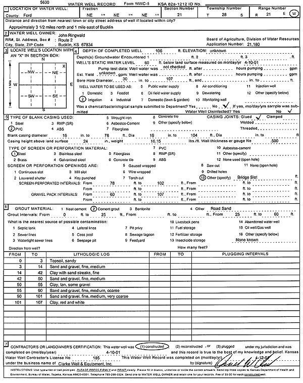
T28S, R21W, Sec. 21 NE NE NE |
Ringwald, John | 106 ft. | 60 ft. | Irrigation | Constructed | 10-Apr-2001 | Scan | ||
| View page: < Prev || 71 || 72 || 73 || 74 || 75 || 76 || 77 || 78 || 79 || 80 || Next > | |||||||||