Select location of well to view details.
Click on column heading to sort.
|
|
|
County: Ford Select location of well to view details. Click on column heading to sort. |
|
|
|
| View page: < Prev || 81 || 82 || 83 || 84 || 85 || 86 || 87 || 88 || 89 || 90 || Next > | |||||||||
| T-R-S | Owner | Well Depth Ascend. Desc. |
Static Water Level Ascend. Desc. |
Est. Yield Ascend. Desc. |
Well Use | Other ID | Action Taken | Completion Date Ascend. Desc. |
Scan? |
|
T28S, R25W, Sec. 35 NE NE NE |
Nicholson, Myron | 190 ft. | 150 ft. | 40 gpm. | Domestic | Constructed | 23-Nov-1988 | ||
|
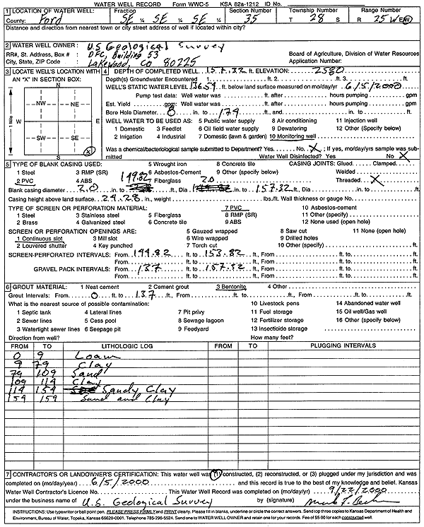
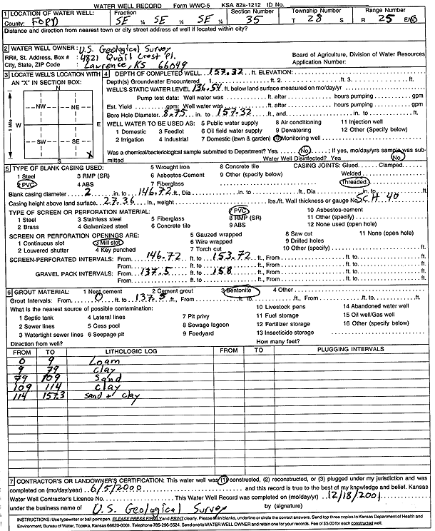
T28S, R25W, Sec. 35 SE SE SE |
U.S. Geological Survey | 157.3 ft. | 136.54 ft. | Monitoring well/observation/piezometer | Constructed | 05-Jun-2000 | Scan | ||
|
T28S, R25W, Sec. 35 SE SE SE |
U.S. Geological Survey | 157.32 ft. | 136.54 ft. | Monitoring well/observation/piezometer | CAI 125 | Constructed | 05-Jun-2000 | Scan | |
|
T28S, R25W, Sec. 35 SW SW SW |
Western Well | 240 ft. | 178 ft. | 10 gpm. | Monitoring well/observation/piezometer | Constructed | 17-May-1985 | ||
|
T28S, R25W, Sec. 36 SW SW NW |
Nicholson, Myron | 200 ft. | 142 ft. | Domestic | Constructed | 02-Apr-1990 | |||
|
T28S, R26W, Sec. 1 SW SW NW |
Double H Farms, Inc. | 250 ft. | 141 ft. | Irrigation | Constructed | 08-May-2007 | |||
|
T28S, R26W, Sec. 1 C SW |
Foulks, Charlie | 212 ft. | 97 ft. | 2500 gpm. | Irrigation | Constructed | 18-Apr-1977 | ||
|
T28S, R26W, Sec. 1 C SE |
Greenwood, Leo | 244 ft. | 104 ft. | Irrigation | Constructed | 12-Oct-1976 | |||
|
T28S, R26W, Sec. 1 NW NE NW |
Robinson, Irvin | 186 ft. | 131 ft. | 1100 gpm. | Irrigation | Constructed | 10-Sep-1976 | ||
|
T28S, R26W, Sec. 2 C N2 SW |
Greenwood, Albert | 257 ft. | 115 ft. | 2000 gpm. | Irrigation | Constructed | 26-Oct-1976 | ||
|
T28S, R26W, Sec. 2 C SE |
Mornger, Esther | 215 ft. | 117 ft. | 1400 gpm. | Irrigation | Constructed | 01-Jun-1976 | ||
|
T28S, R26W, Sec. 3 NE NW NE |
Eaton, Onieta | 174 ft. | 15 ft. | Domestic | Plugged | 17-May-2006 | |||
|
T28S, R26W, Sec. 3 NE NW SW |
Greenwood, Albert | 224 ft. | 140 ft. | 1260 gpm. | Irrigation | Constructed | 18-Nov-1976 | ||
|
T28S, R26W, Sec. 3 NE NW NW |
Scnheweis, Kurt | 280 ft. | 182 ft. | Irrigation | Constructed | 04-Mar-2025 |
KOLAR |
||
|
T28S, R26W, Sec. 4 NW NE NE NW |
Giardine, Mike | 550 ft. | 166 ft. | 35 gpm. | Domestic | Reconstructed | 10-Mar-2014 | ||
|
T28S, R26W, Sec. 5 NE SW NE NW |
Thompson, Brad | 585 ft. | 215 ft. | 25 gpm. | Domestic, Livestock | Constructed | 14-Feb-2013 |
KOLAR |
|
|
T28S, R26W, Sec. 6 NW NW NW |
Williams, Clark | 210 ft. | 153 ft. | 1177 gpm. | Irrigation | Constructed | 16-Jun-1976 | ||
|
T28S, R26W, Sec. 6 SW SW NE |
Williams, Clark | 485 ft. | 190 ft. | 35 gpm. | Domestic | Constructed | 21-Mar-1996 | Scan | |
|
T28S, R26W, Sec. 6 NW NW NW |
Williams, Clark | 500 ft. | 195 ft. | 50 gpm. | Domestic | Constructed | 14-Dec-1995 | Scan | |
|
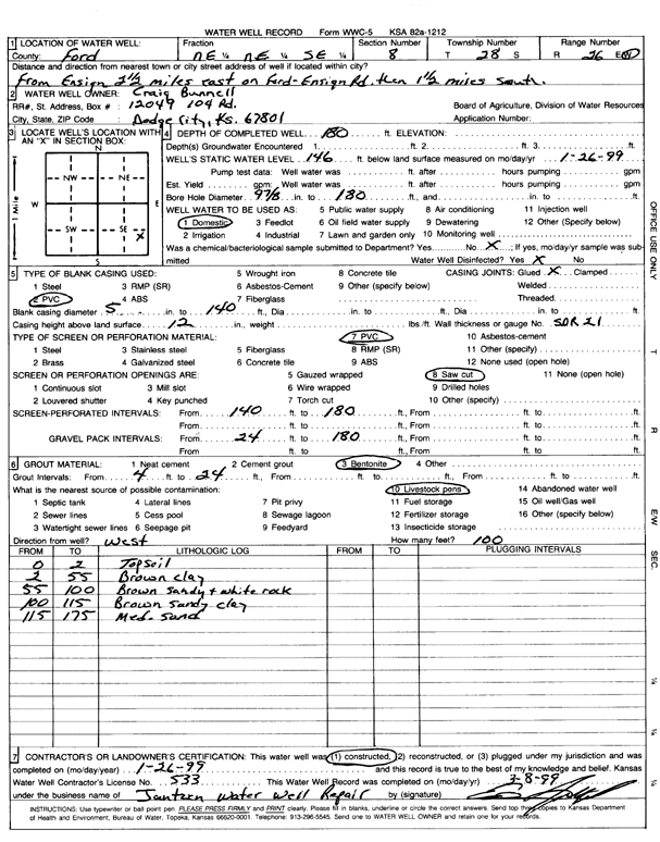
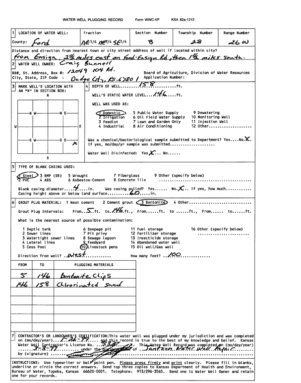
T28S, R26W, Sec. 8 NE NE SE |
Bunnell, Craig | 180 ft. | 146 ft. | Domestic | Constructed | 26-Jan-1999 | Scan | ||
|
T28S, R26W, Sec. 8 NE NE SE |
Bunnell, Craig | 158 ft. | 146 ft. | Domestic | Plugged | 08-Mar-1999 | Scan | ||
|
T28S, R26W, Sec. 8 SE SE SE NE |
Thompson, Brad | 560 ft. | 239 ft. | 40 gpm. | Domestic, Livestock | Constructed | 10-May-2019 | ||
|
T28S, R26W, Sec. 8 NW NW NW |
Thompson, Si | 190 ft. | 146 ft. | Domestic | Constructed | 18-Mar-1975 | |||
|
T28S, R26W, Sec. 10 NE NE SE |
Reinert, LeRoy | 220 ft. | 147 ft. | 30 gpm. | Domestic | Constructed | 05-Aug-1985 | ||
|
T28S, R26W, Sec. 10 NE NE NW |
S and R Land and Cattle Co | 199 ft. | 93 ft. | 650 gpm. | Irrigation | Constructed | 11-Apr-1978 | ||
|
T28S, R26W, Sec. 11 SW NW SE |
Geist, Tim | 205 ft. | 112 ft. | Domestic | Constructed | 31-Jan-2012 | |||
|
T28S, R26W, Sec. 11 SW NW SE |
Holliday Cattle Co | 203 ft. | 109 ft. | 875 gpm. | Irrigation | Constructed | 16-May-1977 | ||
|
T28S, R26W, Sec. 11 NW NW NE |
Holliday Cattle Co | 182 ft. | 85 ft. | 2000 gpm. | Irrigation | Constructed | 15-May-1977 | ||
|
T28S, R26W, Sec. 11 NE SE SE |
Holliday Cattle Co | 190 ft. | 86 ft. | 900 gpm. | Irrigation | Constructed | 16-May-1977 | ||
|
T28S, R26W, Sec. 11 SW SW NW |
Reinert, Leonard | 225 ft. | 136 ft. | 30 gpm. | Domestic | Constructed | 13-Aug-1979 | ||
|
T28S, R26W, Sec. 12 SW SE SE |
Perrier Feedyard | 158 ft. | 104 ft. | 50 gpm. | Domestic | Constructed | 28-Nov-2000 | ||
|
T28S, R26W, Sec. 12 SW SE SE |
Perrier Feedyard | 100 ft. | Domestic | Plugged | 28-Nov-2000 | ||||
|
T28S, R26W, Sec. 12 NE NW NE |
Zink, Carl | 231 ft. | 125 ft. | Domestic | Constructed | 30-Aug-1982 | |||
|
T28S, R26W, Sec. 13 NW NE NE SE |
Woydziak, Don | 224 ft. | 160 ft. | 50 gpm. | Domestic | Constructed | 11-Mar-2009 | ||
|
T28S, R26W, Sec. 13 NE NE NE |
Zink, Carl | 221 ft. | 118 ft. | 1100 gpm. | Irrigation | Constructed | 22-Sep-1977 | ||
|
T28S, R26W, Sec. 14 NW NW NE |
Perrier Feedyard | 186 ft. | 149 ft. | 5 gpm. | Domestic | Constructed | 01-May-2003 | ||
|
T28S, R26W, Sec. 14 NW NW NE |
Perrier Feedyard | 158 ft. | 149 ft. | Domestic | Plugged | 25-Apr-2003 | |||
|
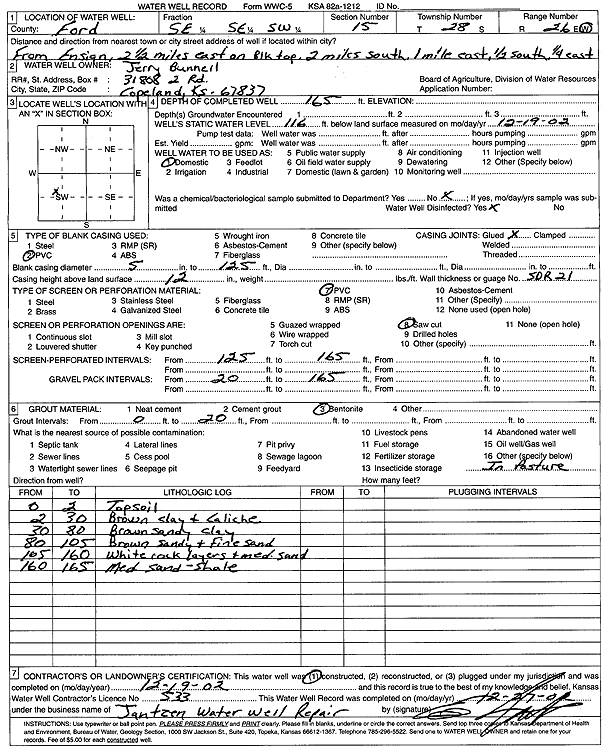
T28S, R26W, Sec. 15 SE SE SW |
Jerry Bunnell | 165 ft. | 116 ft. | Domestic | Constructed | 19-Dec-2002 | Scan | ||
|
T28S, R26W, Sec. 15 NE NE NE |
Reinert, LeRoy | 180 ft. | 160 ft. | 2 gpm. | Domestic | Constructed | 08-Aug-1985 | ||
|
T28S, R26W, Sec. 18 NE NE NE |
Sayre, Stephen R | 200 ft. | 170 ft. | Domestic | Constructed | 17-Mar-1975 | |||
|
T28S, R26W, Sec. 18 NE NE NE NE |
Sayre, Steve | 525 ft. | 195 ft. | 30 gpm. | Domestic, Livestock | Constructed | 21-Feb-2014 | ||
|
T28S, R26W, Sec. 21 SE NE SW SW |
Hamilton, Todd | 180 ft. | 150 ft. | Domestic | Plugged | 16-Mar-2015 | |||
|
T28S, R26W, Sec. 23 NE NW NW |
Farmland National Beef | 194 ft. | 101 ft. | Monitoring well/observation/piezometer | TH 15-03 | Constructed | 28-Apr-2003 | Scan | |
|
T28S, R26W, Sec. 23 NE NW NW |
Farmland National Beef | 194 ft. | 101 ft. | Monitoring well/observation/piezometer | Plugged | 22-May-2004 | |||
|
T28S, R26W, Sec. 24 NW NW NW |
Foulks, Charlie | 195 ft. | 82 ft. | Domestic | Constructed | 11-Jun-1985 | |||
|
T28S, R26W, Sec. 25 C SE NW |
Foulks, Charles W | 202 ft. | 127 ft. | Oil Field Water Supply | Constructed | 19-Nov-1987 | |||
|
T28S, R26W, Sec. 25 NE SE SW |
Perrier, John | 210 ft. | 170 ft. | Domestic | Constructed | 19-Nov-1975 | |||
|
T28S, R26W, Sec. 25 SE NE SW |
Perrier, John | 200 ft. | 170 ft. | 20 gpm. | Feedlot | Constructed | 24-Jun-1983 | ||
|
T28S, R26W, Sec. 25 SE SW SE |
Perrier, John | 195 ft. | 160 ft. | 10 gpm. | Domestic | Constructed | 08-Aug-1986 | ||
|
T28S, R26W, Sec. 25 NE NW SE |
Perrier, John | 180 ft. | 160.5 ft. | 40 gpm. | Feedlot | Constructed | 16-Aug-1996 | ||
| View page: < Prev || 81 || 82 || 83 || 84 || 85 || 86 || 87 || 88 || 89 || 90 || Next > | |||||||||