Select location of well to view details.
Click on column heading to sort.
|
|
|
County: Ford Select location of well to view details. Click on column heading to sort. |
|
|
|
| View page: < Prev || 81 || 82 || 83 || 84 || 85 || 86 || 87 || 88 || 89 || 90 || Next > | |||||||||
| T-R-S | Owner | Well Depth Ascend. Desc. |
Static Water Level Ascend. Desc. |
Est. Yield Ascend. Desc. |
Well Use | Other ID | Action Taken | Completion Date Ascend. Desc. |
Scan? |
|
T28S, R26W, Sec. 26 NW NW NE |
Foote, Arthur | 200 ft. | 167 ft. | Industrial | Constructed | 21-Apr-1976 | |||
|
T28S, R26W, Sec. 31 SE SE SE SW |
Bartlett, Mike | 140 ft. | 86 ft. | 50 gpm. | Domestic, Livestock | Constructed | 05-Oct-2010 | ||
|
T28S, R26W, Sec. 31 SW SW SE |
Waters, Bill | 108 ft. | 80 ft. | 25 gpm. | Domestic | Constructed | 27-May-1975 | ||
|
T28S, R26W, Sec. 32 SW NE NE NE |
Dohrman, Mike | 168 ft. | 111 ft. | 50 gpm. | Domestic, Livestock | Constructed | 22-Apr-2008 | ||
|
T28S, R26W, Sec. 32 C SE |
Hamilton, Verna | 172 ft. | 93 ft. | 30 gpm. | Domestic | Constructed | 01-Aug-2008 | ||
|
T28S, R26W, Sec. 32 NE SW NW |
Young, Donnie | 748 ft. | 374 ft. | 352 gpm. | Irrigation | Constructed | 31-Oct-2024 |
KOLAR |
|
|
T28S, R26W, Sec. 34 SE SW NE SW |
McGee, Duane | 160 ft. | Domestic, Livestock | Plugged | 21-Mar-2017 | ||||
|
T28S, R26W, Sec. 36 NE NE NE |
Buchanan, Floyd | 220 ft. | 170 ft. | Domestic | Constructed | 24-Jun-1976 | |||
|
T29S, R21W, Sec. 2 NE NE NW |
Lamb, Mrs. C P | 100 ft. | 70 ft. | 20 gpm. | Domestic | Constructed | 13-Mar-1985 | ||
|
T29S, R21W, Sec. 2 NE NE NE |
Pickrell Drilling Co. | 160 ft. | 120 ft. | Oil Field Water Supply | Constructed | 25-Mar-1983 | |||
|
T29S, R21W, Sec. 3 NE NE SW |
Clevenger, Dustin | 177 ft. | 123 ft. | Irrigation | Constructed | 24-Mar-2003 | Scan | ||
|
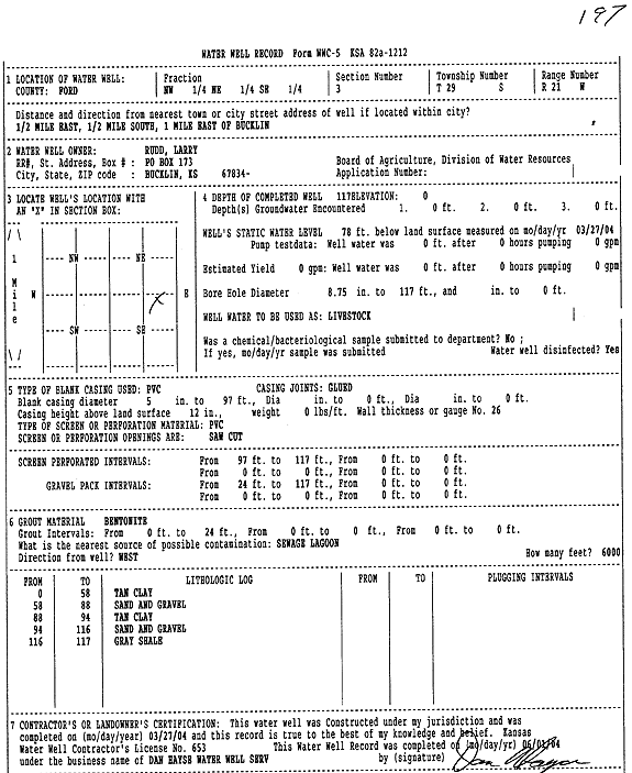
T29S, R21W, Sec. 3 NW NE SE |
Rudd, Larry | 117 ft. | 78 ft. | Feedlot/Livestock/Windmill | Constructed | 27-Mar-2004 | Scan | ||
|
T29S, R21W, Sec. 4 S2 SW SW |
Barnhart, Gordon | 114 ft. | 89 ft. | 15 gpm. | Domestic | Constructed | 07-Feb-1975 | ||
|
T29S, R21W, Sec. 4 SE NE SE |
Clevenger, Dustin | 106 ft. | 71 ft. | Irrigation | Constructed | 27-Jun-2012 | |||
|
T29S, R21W, Sec. 4 SW SW NE |
Clevenger, Dustin | 104 ft. | 75 ft. | 50 gpm. | Domestic | Constructed | 03-Jul-2001 | ||
|
T29S, R21W, Sec. 4 NW NW SE |
Evans, Roy | 120 ft. | 92 ft. | 10 gpm. | Domestic | Constructed | 03-Oct-1985 | ||
|
T29S, R21W, Sec. 5 SW SW SW |
Bucklin Cemetery | 125 ft. | 105 ft. | Irrigation | Plugged | 19-Nov-1993 | |||
|
T29S, R21W, Sec. 5 SW SW SW |
Bucklin Cemetery | 130 ft. | 100 ft. | 15 gpm. | Domestic, Lawn and Garden | Constructed | 11-Apr-1985 | ||
|
T29S, R21W, Sec. 5 NW NE SE |
Bucklin Coop | 116.5 ft. | 104 ft. | Monitoring well/observation/piezometer | MW 10 | Constructed | 01-Feb-1993 | ||
|
T29S, R21W, Sec. 5 NW NE SE |
Bucklin Coop | 118 ft. | 104 ft. | Monitoring well/observation/piezometer | OBW 1 | Constructed | 02-Feb-1993 | ||
|
T29S, R21W, Sec. 5 NW NE SE |
Bucklin Coop | 117 ft. | 104 ft. | Monitoring well/observation/piezometer | MW 12 | Constructed | 21-Jan-1993 | ||
|
T29S, R21W, Sec. 5 NW NE SE |
Bucklin Coop | 128 ft. | 104 ft. | Monitoring well/observation/piezometer | PW 1 | Constructed | 03-Feb-1993 | ||
|
T29S, R21W, Sec. 5 NW NE SE |
Bucklin Coop | 118.5 ft. | 104 ft. | Monitoring well/observation/piezometer | MW 13 | Constructed | 22-Jan-1993 | ||
|
T29S, R21W, Sec. 5 NW NE SE |
Bucklin Coop | 100 ft. | Environmental Remediation, Soil Vapor Extraction | SVE 2 | Constructed | 25-Jan-1993 | |||
|
T29S, R21W, Sec. 5 NW NE SE |
Bucklin Coop | 100 ft. | Environmental Remediation, Soil Vapor Extraction | SVE 3 | Constructed | 26-Jan-1993 | |||
|
T29S, R21W, Sec. 5 NW NE SE |
Bucklin Coop | 100 ft. | Environmental Remediation, Soil Vapor Extraction | VEW 1 | Constructed | 21-Jan-1993 | |||
|
T29S, R21W, Sec. 5 NW NE SE |
Bucklin Coop | 100 ft. | 104 ft. | Environmental Remediation, Soil Vapor Extraction | SVE 1 | Constructed | 19-Jan-1993 | ||
|
T29S, R21W, Sec. 5 NW NE SE |
Bucklin Coop | 117.5 ft. | 104 ft. | Monitoring well/observation/piezometer | MW 9 | Constructed | 27-Jan-1993 | ||
|
T29S, R21W, Sec. 5 NW NE SE |
Bucklin Coop | 112.25 ft. | 105 ft. | Monitoring well/observation/piezometer | MW 5 | Plugged | 05-Oct-1994 | ||
|
T29S, R21W, Sec. 5 NW NE SE |
Bucklin Coop | 112.35 ft. | 103 ft. | Monitoring well/observation/piezometer | MW 4 | Plugged | 04-Oct-1994 | ||
|
T29S, R21W, Sec. 5 NW NE SE |
Bucklin Coop | 112.6 ft. | 99.5 ft. | Monitoring well/observation/piezometer | MW 1 | Constructed | 20-May-1991 | ||
|
T29S, R21W, Sec. 5 NW NE SE |
Bucklin Coop | 110.2 ft. | 100.7 ft. | Monitoring well/observation/piezometer | MW 2 | Constructed | 21-May-1991 | ||
|
T29S, R21W, Sec. 5 NW NE SE |
Bucklin Coop | 113.5 ft. | 101.85 ft. | Monitoring well/observation/piezometer | MW 7 | Constructed | 28-May-1991 | ||
|
T29S, R21W, Sec. 5 NW NE SE |
Bucklin Coop | 112 ft. | 105.35 ft. | Monitoring well/observation/piezometer | MW 5 | Constructed | 22-May-1991 | ||
|
T29S, R21W, Sec. 5 NW NE SE |
Bucklin Coop | 112 ft. | 100.41 ft. | Monitoring well/observation/piezometer | MW 3 | Constructed | 24-May-1991 | ||
|
T29S, R21W, Sec. 5 NW NE SE |
Bucklin Coop | 110 ft. | 102.65 ft. | Monitoring well/observation/piezometer | MW 6 | Constructed | 29-May-1991 | ||
|
T29S, R21W, Sec. 5 NW NE SE |
Bucklin Coop | 119 ft. | 104 ft. | Monitoring well/observation/piezometer | MW 11 | Constructed | 26-Jan-1993 | ||
|
T29S, R21W, Sec. 5 NW NE SE |
Bucklin Coop | 116.5 ft. | 104 ft. | Monitoring well/observation/piezometer | OBW 2 | Constructed | 08-Feb-1993 | ||
|
T29S, R21W, Sec. 5 NW NE SE |
Bucklin Coop | 112 ft. | 103.85 ft. | Monitoring well/observation/piezometer | MW 4 | Constructed | 23-May-1991 | ||
|
T29S, R21W, Sec. 5 NW NE SE |
Bucklin Coop | 113 ft. | 101.75 ft. | Monitoring well/observation/piezometer | MW 8 | Constructed | 30-May-1991 | ||
|
T29S, R21W, Sec. 5 NW SE NE |
City of Bucklin | 129 ft. | 102 ft. | Public Water Supply | Well 6 | Plugged | 09-Jan-2008 | ||
|
T29S, R21W, Sec. 5 SE NE SW |
City of Bucklin | 142 ft. | 107 ft. | Public Water Supply | well 9 | Plugged | 29-Apr-2009 | ||
|
T29S, R21W, Sec. 5 NW SW NE |
City of Bucklin | 125 ft. | 101 ft. | Public Water Supply | Well 12 | Plugged | 11-Mar-2011 | ||
|
T29S, R21W, Sec. 5 NW SW NE |
City of Bucklin | 126 ft. | 100 ft. | Public Water Supply | Constructed | 13-Jul-2010 | |||
|
T29S, R21W, Sec. 5 SE NE SW |
City of Bucklin | Monitoring well/observation/piezometer | OB 1 08 | Plugged | 29-Apr-2009 | ||||
|
T29S, R21W, Sec. 5 SE NE SW |
City of Bucklin | 156 ft. | 105.75 ft. | Monitoring well/observation/piezometer | OB 1-08 | Constructed | 02-Jul-2008 | ||
|
T29S, R21W, Sec. 5 NW SW NE |
City of Bucklin | 134 ft. | 99 ft. | Monitoring well/observation/piezometer | 5 Test Well | Plugged | 14-Feb-2008 | ||
|
T29S, R21W, Sec. 5 NW SW NE |
City of Bucklin | 93 ft. | Monitoring well/observation/piezometer | 2 OB | Plugged | 14-Feb-2008 | |||
|
T29S, R21W, Sec. 5 SE NE SW |
City of Bucklin | 151 ft. | 106 ft. | Public Water Supply | well 11 | Constructed | 17-Mar-2009 | ||
|
T29S, R21W, Sec. 5 NE SE SE |
City of Bucklin | 115 ft. | 87 ft. | Public Water Supply | Plugged | 20-Oct-2005 | |||
| View page: < Prev || 81 || 82 || 83 || 84 || 85 || 86 || 87 || 88 || 89 || 90 || Next > | |||||||||