Select location of well to view details.
Click on column heading to sort.
|
|
|
County: Ford Select location of well to view details. Click on column heading to sort. |
|
|
|
| View page: 1 || 2 || 3 || 4 || 5 || 6 || 7 || 8 || 9 || 10 || Next > | |||||||||
| T-R-S | Owner | Well Depth Ascend. Desc. |
Static Water Level Ascend. Desc. |
Est. Yield Ascend. Desc. |
Well Use | Other ID | Action Taken | Completion Date Ascend. Desc. |
Scan? |
|
T26S, R21W, Sec. 13 NW NW SW |
Viking Resources, Inc. | 76 ft. | 13 ft. | Oil Field Water Supply | Constructed | 03-Nov-1992 | |||
|
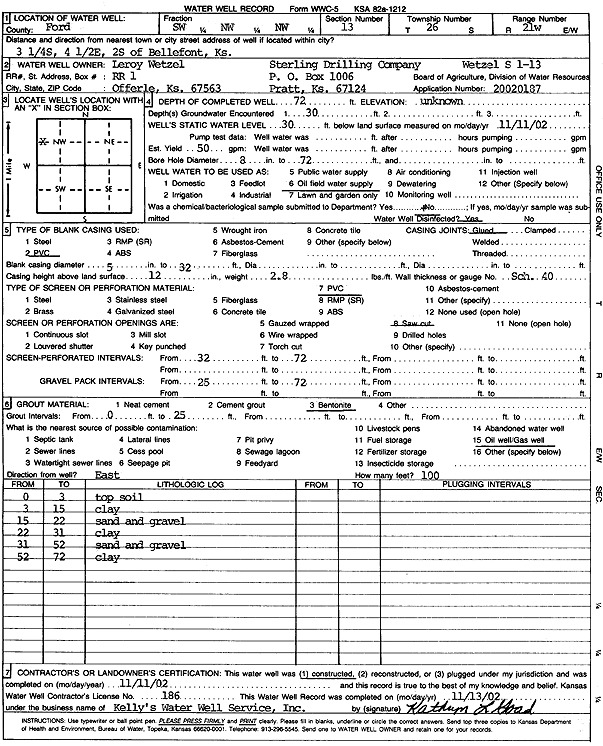
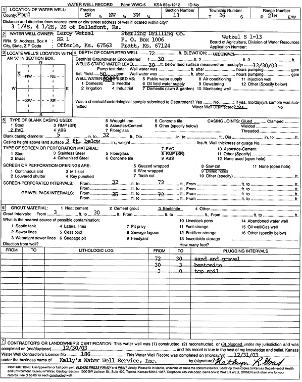
T26S, R21W, Sec. 13 SW NW NW |
Wetzel, Leroy/Sterling Drilling Co. | 72 ft. | 30 ft. | 50 gpm. | Oil Field Water Supply | Wetzel S 1-13 | Constructed | 11-Nov-2002 | Scan |
|
T26S, R21W, Sec. 13 SW NW NW |
Wetzel, Leroy/Sterling Drilling Co. | 72 ft. | 30 ft. | 50 gpm. | Oil Field Water Supply | Wetzel S 1-13 | Plugged | 30-Dec-2003 | Scan |
|
T26S, R21W, Sec. 14 S2 NE |
Fox, Jerome | 84 ft. | 24 ft. | Irrigation | Constructed | 16-Jul-1976 | |||
|
T26S, R21W, Sec. 14 NW NW SW |
Wetzel, Ruth | 95 ft. | 22 ft. | Domestic, Livestock | Constructed | 13-Jun-2013 | |||
|
T26S, R21W, Sec. 15 C SE SW |
Rains and Williamson Oil Co. | 100 ft. | 27 ft. | 60 gpm. | Oil Field Water Supply | Constructed | 11-Mar-1977 | ||
|
T26S, R21W, Sec. 16 C SW NE |
Allen Drilling Co. | 85 ft. | 35 ft. | Oil Field Water Supply | Constructed | 16-Jan-1986 | |||
|
T26S, R21W, Sec. 17 SE SE NW SW |
Marschell, Linda | 300 ft. | 86 ft. | 20 gpm. | Domestic | Constructed | 23-May-2012 | ||
|
T26S, R21W, Sec. 19 SW |
Heeke, Rick | 80 ft. | 21 ft. | Domestic, Livestock | Constructed | 07-Aug-2006 | |||
|
T26S, R21W, Sec. 20 NW SW SW |
Stein, Trevin | 78 ft. | 18 ft. | 50 gpm. | Domestic | Constructed | 16-Jul-2003 | ||
|
T26S, R21W, Sec. 21 SE SE SE |
Tasset, Paul | 270 ft. | 225 ft. | 15 gpm. | Domestic, Livestock | Constructed | 19-Dec-1977 | ||
|
T26S, R21W, Sec. 21 SE SE NE |
Weiss, Evert | 105 ft. | 46 ft. | 18 gpm. | Domestic | Constructed | 15-Jun-1994 | ||
|
T26S, R21W, Sec. 21 SE SE NW |
Weiss, Evert | 90 ft. | Domestic | Plugged | 15-Jun-1994 | ||||
|
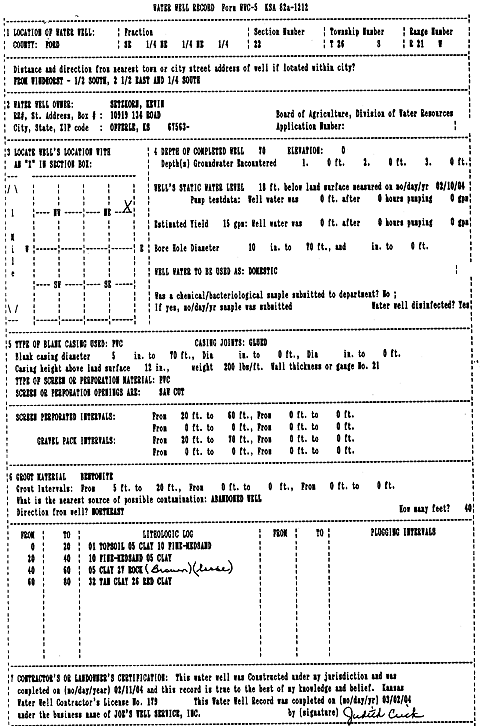
T26S, R21W, Sec. 22 SE NE NE |
Setzkorn, Kevin | 70 ft. | 18 ft. | 15 gpm. | Domestic | Constructed | 11-Feb-2004 | Scan | |
|
T26S, R21W, Sec. 22 NW NW NW |
Zion Lutheran Church | 225 ft. | 38 ft. | 30 gpm. | Domestic | Constructed | 30-Nov-1994 | ||
|
T26S, R21W, Sec. 23 NE NE SW |
Hattrup, Bob | 90 ft. | 25 ft. | Domestic | Constructed | 20-Oct-2004 | |||
|
T26S, R21W, Sec. 24 C NE NW |
Herrman, Gerald/ Pickrell Drilling | 27 ft. | 5 ft. | Oil Field Water Supply | Constructed | 11-Mar-1983 | |||
|
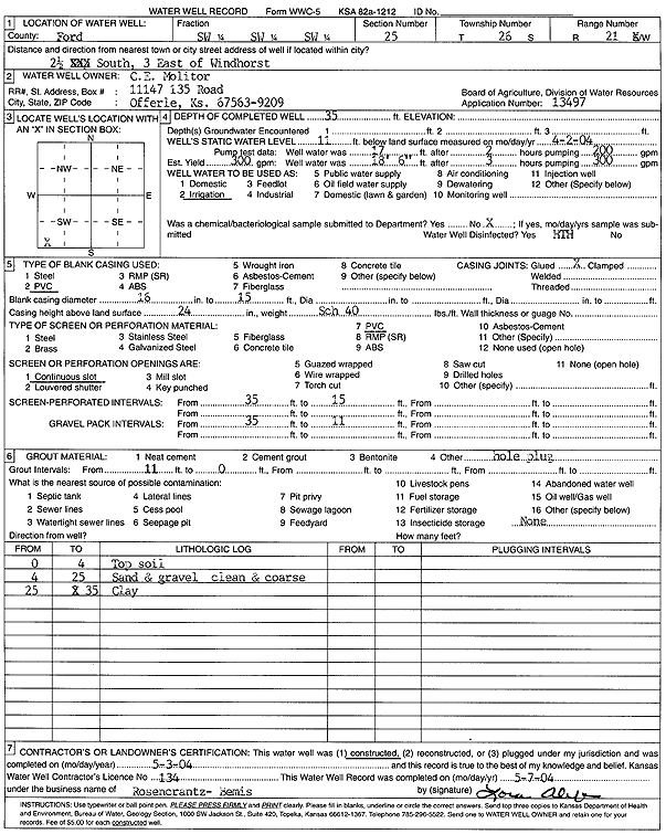
T26S, R21W, Sec. 25 SE SW SW |
Molitor, C E | 28 ft. | 8 ft. | 50 gpm. | Oil Field Water Supply | Molitor B 1-25 | Constructed | 10-Dec-2007 | |
|
T26S, R21W, Sec. 25 SE SW SW |
Molitor, C. E. | 28 ft. | 8 ft. | 50 gpm. | Oil Field Water Supply | Molitor B 1-25 | Plugged | 26-Feb-2008 | |
|
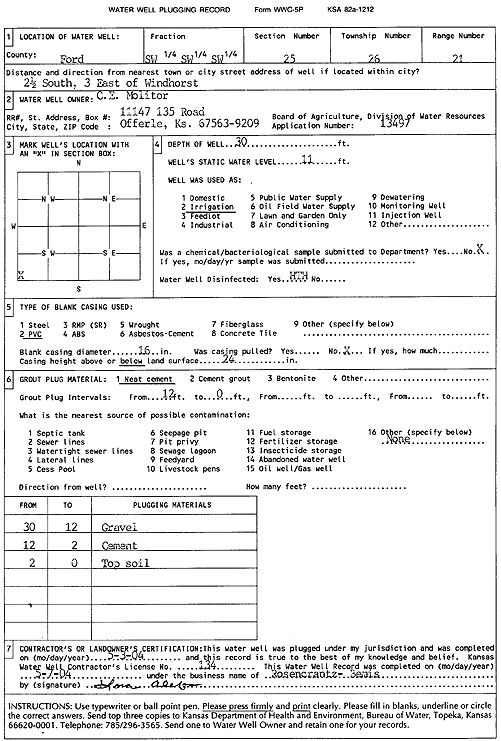
T26S, R21W, Sec. 25 SW SW SW |
Molitor, C.E. | 30 ft. | 11 ft. | Irrigation | Plugged | 03-May-2004 | Scan | ||
|
T26S, R21W, Sec. 25 SW SW SW |
Molitor, C.E. | 35 ft. | 11 ft. | 300 gpm. | Irrigation | Constructed | 03-May-2004 | Scan | |
|
T26S, R21W, Sec. 25 SW NW SW |
Molitor, C.E. | 30 ft. | 6 ft. | 400 gpm. | Irrigation | Constructed | 17-Oct-1989 | ||
|
T26S, R21W, Sec. 25 SW SW NW |
Molitor, Kirk | 40 ft. | 8 ft. | Irrigation | Constructed | 03-Jun-1975 | |||
|
T26S, R21W, Sec. 25 SW SE NW |
Molitor, Kirk | 33.5 ft. | 5 ft. | 300 gpm. | Irrigation | Constructed | 21-May-1975 | ||
|
T26S, R21W, Sec. 25 SW SW SW |
Molitor, Kirk | 31 ft. | 7 ft. | 330 gpm. | Irrigation | Constructed | 23-Mar-2011 | ||
|
T26S, R21W, Sec. 25 NW SE SW |
Molitor, Kirk | 39 ft. | 6 ft. | Domestic, Livestock | Constructed | 07-Nov-2011 | |||
|
T26S, R21W, Sec. 25 NW SW SW |
Molitor, Kirk | 31 ft. | 7 ft. | 336 gpm. | Irrigation | Constructed | 23-Mar-2011 | ||
|
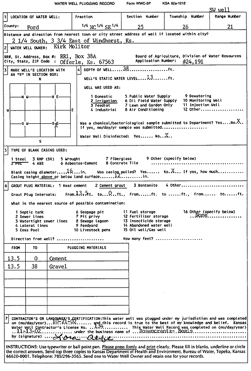
T26S, R21W, Sec. 25 C SE |
Molitor, Kirk | 42 ft. | 13.5 ft. | Irrigation | Pivot well | Plugged | 21-Oct-2002 | Scan | |
|
T26S, R21W, Sec. 25 SW SW NW |
Molitor, Kirk | 29 ft. | 5.5 ft. | Irrigation | Constructed | 03-Jun-1975 | |||
|
T26S, R21W, Sec. 25 SE SW SE |
Molitor, Kirk | 38 ft. | 7.5 ft. | Irrigation | Constructed | 03-Apr-1975 | |||
|
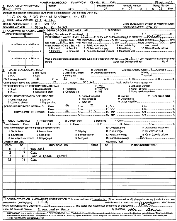
T26S, R21W, Sec. 25 C SE |
Molitor, Kirk | 46 ft. | 13.5 ft. | 400 gpm. | Irrigation | Pivot well | Constructed | 06-Nov-2002 | Scan |
|
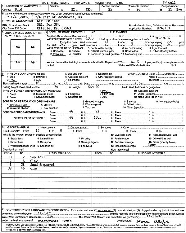
T26S, R21W, Sec. 25 C SE |
Molitor, Kirk | 46 ft. | 13.5 ft. | 375 gpm. | Irrigation | SW well | Constructed | 05-Nov-2002 | Scan |
|
T26S, R21W, Sec. 25 C SE |
Molitor, Kirk | 38 ft. | 13 ft. | Irrigation | SW well | Plugged | 21-Oct-2002 | Scan | |
|
T26S, R21W, Sec. 25 C NE SW |
Raydon Exploration Co., Inc. | 50 ft. | 9 ft. | Oil Field Water Supply | Constructed | 18-Jan-1993 | |||
|
T26S, R21W, Sec. 27 NW NW NW |
Holtferich, Norma | 90 ft. | 20 ft. | Domestic | Plugged | 23-Jun-1993 | |||
|
T26S, R21W, Sec. 27 NW NW NW |
Holtferich, Norma | 240 ft. | 30 ft. | Domestic | Constructed | 15-Jun-1993 | |||
|
T26S, R21W, Sec. 28 SW SW NW |
Klenke, Mike | 95 ft. | 20 ft. | 80 gpm. | Domestic | Constructed | 27-Jun-1986 | ||
|
T26S, R21W, Sec. 28 NE NE SW |
Kolbeck, Ivan | 118 ft. | 15.5 ft. | 800 gpm. | Irrigation | Constructed | 08-Sep-1976 | ||
|
T26S, R21W, Sec. 29 C NW |
Stein, Jack/H 30 Drilling | 50 ft. | 20 ft. | 60 gpm. | Oil Field Water Supply | Stein 1 | Constructed | 26-Jul-1983 | |
|
T26S, R21W, Sec. 29 C SE |
Tieden, Jimmy | 85 ft. | 25 ft. | 60 gpm. | Domestic | Constructed | 24-Aug-1990 | ||
|
T26S, R21W, Sec. 30 NE NE SE |
Downey, Bill | 114 ft. | 50 ft. | 30 gpm. | Domestic | Constructed | 06-Oct-1983 | ||
|
T26S, R21W, Sec. 31 NE NW NW SE |
Powers, Steve | 405 ft. | 82 ft. | 30 gpm. | Domestic | Constructed | 29-May-2012 | ||
|
T26S, R21W, Sec. 31 NE NE NE |
Shean, Henry | 115 ft. | 40 ft. | 20 gpm. | Domestic | Constructed | 01-Jun-1982 | ||
|
T26S, R21W, Sec. 31 NW SW NW |
Shean, Mike | 100 ft. | 18 ft. | Domestic | Constructed | 05-Apr-1997 | |||
|
T26S, R21W, Sec. 32 SW SW NE |
Peintner, Clayton | 100 ft. | 15 ft. | 50 gpm. | Domestic | Constructed | 27-Aug-1982 | ||
|
T26S, R21W, Sec. 32 C NW SE |
Peintner, M./Pickrell Drilling | 185 ft. | Oil Field Water Supply | Plugged | 25-Aug-1982 | ||||
|
T26S, R21W, Sec. 32 C NW SE |
Peintner, M./Pickrell Drilling | 185 ft. | Oil Field Water Supply | Constructed | 25-Aug-1982 | ||||
|
T26S, R21W, Sec. 32 NE NE SW |
Tieven/Mustang Drilling | 180 ft. | 50 ft. | Oil Field Water Supply | Tieven lease | Constructed | 15-Nov-1981 | ||
|
T26S, R21W, Sec. 34 SE NE SE |
Molitor, Kirk | 40 ft. | 10 ft. | Domestic, Livestock | Constructed | 30-Nov-2012 | |||
|
T26S, R21W, Sec. 35 NW SW SW |
Molitor, Kirk | 40 ft. | 8 ft. | Domestic, Livestock | Constructed | 25-Nov-2019 | |||
| View page: 1 || 2 || 3 || 4 || 5 || 6 || 7 || 8 || 9 || 10 || Next > | |||||||||