Select location of well to view details.
Click on column heading to sort.
|
|
|
County: Ford Select location of well to view details. Click on column heading to sort. |
|
|
|
| View page: < Prev || 91 || 92 || 93 || 94 || 95 || 96 || 97 || 98 || 99 | |||||||||
| T-R-S | Owner | Well Depth Ascend. Desc. |
Static Water Level Ascend. Desc. |
Est. Yield Ascend. Desc. |
Well Use | Other ID | Action Taken | Completion Date Ascend. Desc. |
Scan? |
|
T29S, R22W, Sec. 5 NW SE NW SE |
Vincent Oil Corp. | 210 ft. | 184 ft. | Oil Field Water Supply | Rotz 1-15 | Plugged | 23-Mar-2020 | ||
|
T29S, R22W, Sec. 5 SE NE SE SE |
Vincent Oil Corp. | 210 ft. | 160 ft. | 20 gpm. | Oil Field Water Supply | Rotz 2-5 | Constructed | 04-Nov-2020 |
KOLAR |
|
T29S, R22W, Sec. 5 NW SE NW SE |
Vincent Oil Corp. | 210 ft. | 163 ft. | Oil Field Water Supply | Plugged | 16-Apr-2020 | |||
|
T29S, R22W, Sec. 5 NW SE NW SE |
Vincent Oil Corp. | 210 ft. | 163 ft. | Oil Field Water Supply | Rotz 1-15 | Constructed | 17-Oct-2019 | ||
|
T29S, R22W, Sec. 5 SE NE SE SE |
Vincent Oil Corp. | 210 ft. | 160 ft. | Oil Field Water Supply | Rotz 2-5 | Plugged | 06-May-2021 |
KOLAR |
|
|
T29S, R22W, Sec. 5 NW SW SW |
Vincent Oil Corp. | 250 ft. | 190 ft. | Oil Field Water Supply | Constructed | 29-Jun-2015 | |||
|
T29S, R22W, Sec. 5 NE NE SE |
White, David | 193 ft. | 129 ft. | 1100 gpm. | Irrigation | Constructed | 24-Oct-1978 | ||
|
T29S, R22W, Sec. 6 SE SW NE |
Vincent Oil Co. | 230 ft. | 181 ft. | Oil Field Water Supply | Imel 3-6 | Constructed | 18-Nov-2016 | ||
|
T29S, R22W, Sec. 6 NW NE SE |
Vincent Oil Corp. | 247 ft. | 192 ft. | Oil Field Water Supply | Constructed | 08-Nov-2014 | |||
|
T29S, R22W, Sec. 6 SW NW NE SE |
Vincent Oil Corp. | 247 ft. | 192 ft. | Oil Field Water Supply | Plugged | 21-Aug-2020 |
KOLAR |
||
|
T29S, R22W, Sec. 6 NW SE SW NE |
Vincent Oil Corp. | 230 ft. | 181 ft. | Oil Field Water Supply | Imel 3-6 | Plugged | 21-Aug-2020 |
KOLAR |
|
|
T29S, R22W, Sec. 7 NW NW NW |
Clevenger, Dustin (was Vincent Oil Co) | 242 ft. | 166 ft. | Domestic, changed from Oil Field Water Supply | Constructed | 17-Dec-2009 | |||
|
T29S, R22W, Sec. 7 SW SE NE |
Imel, Charles (Vincent Oil Corp) | 250 ft. | 187 ft. | Domestic, changed from Oil Field Water Supply | Constructed | 31-Aug-2009 | |||
|
T29S, R22W, Sec. 7 NE NE NE |
Smith, M G | 243 ft. | 186 ft. | Domestic | Constructed | 17-May-2008 | |||
|
T29S, R22W, Sec. 8 NW SE NW NE |
Feikert Farms LLC (was Vincent Oil) | 225 ft. | 168 ft. | Domestic, changed from Oil Field Water Supply | Constructed | 24-Oct-2011 | |||
|
T29S, R22W, Sec. 8 SE SE SW NE |
Feikert Farms LLC (was Vincent Oil) | 235 ft. | 144 ft. | Domestic, changed from Oil Field Water Supply | Constructed | 08-Jan-2014 | |||
|
T29S, R22W, Sec. 8 NE NE SE |
Feikert, Larry | 255 ft. | 179 ft. | 50 gpm. | Domestic, Livestock | Constructed | 26-Dec-2024 |
KOLAR |
|
|
T29S, R22W, Sec. 8 SE NE NW NW |
Vincent Oil Corp. | 235 ft. | 145 ft. | Oil Field Water Supply | Plugged | 10-Aug-2015 | |||
|
T29S, R22W, Sec. 8 NE NE NW |
Vincent Oil Corp. | 230 ft. | 143 ft. | Oil Field Water Supply | Smith 3-8 | Plugged | 04-Sep-2024 |
KOLAR |
|
|
T29S, R22W, Sec. 8 SE NE NW NW |
Vincent Oil Corp. | 235 ft. | 145 ft. | Oil Field Water Supply | Constructed | 22-Mar-2014 | |||
|
T29S, R22W, Sec. 8 NE NE NW |
Vincent Oil Corp. | 230 ft. | 143 ft. | Oil Field Water Supply | Smith 3-8 | Constructed | 31-May-2019 | ||
|
T29S, R22W, Sec. 9 SE NW NE SW |
Feikert, Larry K. (was Vincent Oil) | 217 ft. | 160 ft. | Domestic, changed from Oil Field Water Supply | Constructed | 23-May-2011 | |||
|
T29S, R22W, Sec. 9 SW SW SE |
Samuel Gary Oil Co | 210 ft. | 143 ft. | 50 gpm. | Oil Field Water Supply | Williams 9-15 | Constructed | 11-Mar-1981 | |
|
T29S, R22W, Sec. 9 NW NE SW NW |
Vincent Oil Co. | 223 ft. | 150 ft. | Oil Field Water Supply | Plugged | 04-Aug-2011 | |||
|
T29S, R22W, Sec. 9 SE NW NE SW |
Vincent Oil Co. | 217 ft. | 160 ft. | Oil Field Water Supply | Constructed | 23-May-2011 | |||
|
T29S, R22W, Sec. 9 NW NE SW NW |
Vincent Oil Co. | 223 ft. | 150 ft. | Oil Field Water Supply | Constructed | 04-Aug-2011 | |||
|
T29S, R22W, Sec. 9 SE NE NW SE |
Vincent Oil Co. | 215 ft. | 158 ft. | Oil Field Water Supply | Constructed | 31-Aug-2012 | |||
|
T29S, R22W, Sec. 9 NE NE NE NW |
Vincent Oil Corp. | 188 ft. | 140 ft. | Oil Field Water Supply | Overmyer 3-9 | Constructed | 11-Nov-2019 | ||
|
T29S, R22W, Sec. 9 SE NE NW SE |
Vincent Oil Corp. | 215 ft. | 158 ft. | Oil Field Water Supply | Plugged | 17-Nov-2012 | |||
|
T29S, R22W, Sec. 9 SW SW SW |
Vincent Oil Corp. | 210 ft. | 133 ft. | Oil Field Water Supply | Constructed | 26-Jun-2014 | |||
|
T29S, R22W, Sec. 9 C NE |
Williams, Charles | 180 ft. | 100 ft. | 1100 gpm. | Irrigation | Constructed | 18-Aug-1976 | ||
|
T29S, R22W, Sec. 10 SW SW NW |
Samuel Gary Oil Co | 224 ft. | 133 ft. | 50 gpm. | Oil Field Water Supply | Close 10-5 | Constructed | 14-May-1981 | |
|
T29S, R22W, Sec. 10 SW NE SW |
Silverado Drilling Co. | 185 ft. | 132 ft. | 70 gpm. | Oil Field Water Supply | Horner | Constructed | 02-Sep-1981 | |
|
T29S, R22W, Sec. 11 NE SW NW |
Dewell, Jeremy | 109 ft. | Domestic | Plugged | 22-Nov-2005 | ||||
|
T29S, R22W, Sec. 11 NE NW SW |
Silverado Drilling Co. | 187 ft. | 125 ft. | 60 gpm. | Oil Field Water Supply | Rupp 1 | Constructed | 05-Aug-1981 | |
|
T29S, R22W, Sec. 12 SW SW NW |
Hutton Trust | 140 ft. | 130 ft. | Domestic | Plugged | 26-Mar-1993 | |||
|
T29S, R22W, Sec. 12 SW NE NE |
Popp Farms | 152 ft. | 90 ft. | Domestic, changed from Irrigation | Reconstructed | 01-May-2009 | |||
|
T29S, R22W, Sec. 12 SW NE NE |
Popp, Harlan | 152 ft. | 90 ft. | 786 gpm. | Irrigation | Constructed | 30-Sep-1976 | ||
|
T29S, R22W, Sec. 12 NE NE NE |
Popp, Harlan | 163 ft. | 102 ft. | 35 gpm. | Domestic | Constructed | 02-Mar-1985 | ||
|
T29S, R22W, Sec. 12 SW SW NW |
Stimpert, Waldo | 132 ft. | 81 ft. | Domestic | Constructed | 19-Mar-1993 | |||
|
T29S, R22W, Sec. 12 SE SE NW |
Withers, Mrs. Sam | 160 ft. | 126 ft. | 15 gpm. | Domestic | Constructed | 08-May-1984 | ||
|
T29S, R22W, Sec. 13 SE NW NW |
Schoonover, Homer | 225 ft. | 155 ft. | Domestic | Constructed | 25-Nov-1990 | |||
|
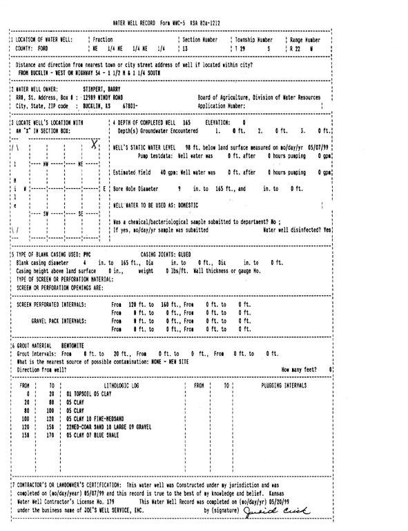
T29S, R22W, Sec. 13 NE NE NE |
Stimpert, Barry | 165 ft. | 98 ft. | 40 gpm. | Domestic | Constructed | 07-May-1999 | Scan | |
|
T29S, R22W, Sec. 13 NE NE NE |
Stimpert, Barry | 160 ft. | 97 ft. | 40 gpm. | Domestic | Constructed | 25-Oct-1997 | ||
|
T29S, R22W, Sec. 13 NW SE NE |
Stimpert, Barry | 165 ft. | 98 ft. | 25 gpm. | Domestic | Constructed | 18-Apr-1998 | ||
|
T29S, R22W, Sec. 14 NW NW NE |
Hutton, Rod | 199 ft. | 120 ft. | 1600 gpm. | Irrigation | Constructed | 01-Mar-1977 | ||
|
T29S, R22W, Sec. 14 NW NE SE SE |
Vincent Oil Corp. | 190 ft. | 138 ft. | Oil Field Water Supply | Plugged | 25-Mar-2014 | |||
|
T29S, R22W, Sec. 14 NW NE SE SE |
Vincent Oil Corp. | 190 ft. | 138 ft. | Oil Field Water Supply | Constructed | 05-Oct-2013 | |||
|
T29S, R22W, Sec. 15 NW NW NE |
Darst, Merle | 200 ft. | 167 ft. | 20 gpm. | Domestic | Constructed | 05-May-1984 | ||
|
T29S, R22W, Sec. 15 NE NW SE NW |
Ellis, Marilyn (was Vincent Oil Co) | 207 ft. | 153 ft. | Domestic, changed from Oil Field Water Supply | Constructed | 13-Oct-2011 | |||
| View page: < Prev || 91 || 92 || 93 || 94 || 95 || 96 || 97 || 98 || 99 | |||||||||