Select location of well to view details.
Click on column heading to sort.
|
|
|
County: Ford Select location of well to view details. Click on column heading to sort. |
|
|
|
| View page: < Prev || 91 || 92 || 93 || 94 || 95 || 96 || 97 || 98 || 99 | |||||||||
| T-R-S | Owner | Well Depth Ascend. Desc. |
Static Water Level Ascend. Desc. |
Est. Yield Ascend. Desc. |
Well Use | Other ID | Action Taken | Completion Date Ascend. Desc. |
Scan? |
|
T29S, R23W, Sec. 5 SW NE NW SW |
Vincent Oil Co. | 190 ft. | 76 ft. | Oil Field Water Supply | Constructed | 20-Nov-2009 | |||
|
T29S, R23W, Sec. 5 SW NE NW |
Vincent Oil Corp. | 180 ft. | 78 ft. | Oil Field Water Supply | C & D Herrmann 2-5 | Constructed | 04-Apr-2024 |
KOLAR |
|
|
T29S, R23W, Sec. 5 NW NE NE |
Vincent Oil Corp. | 210 ft. | 129 ft. | Oil Field Water Supply | Constructed | 12-Mar-2012 | |||
|
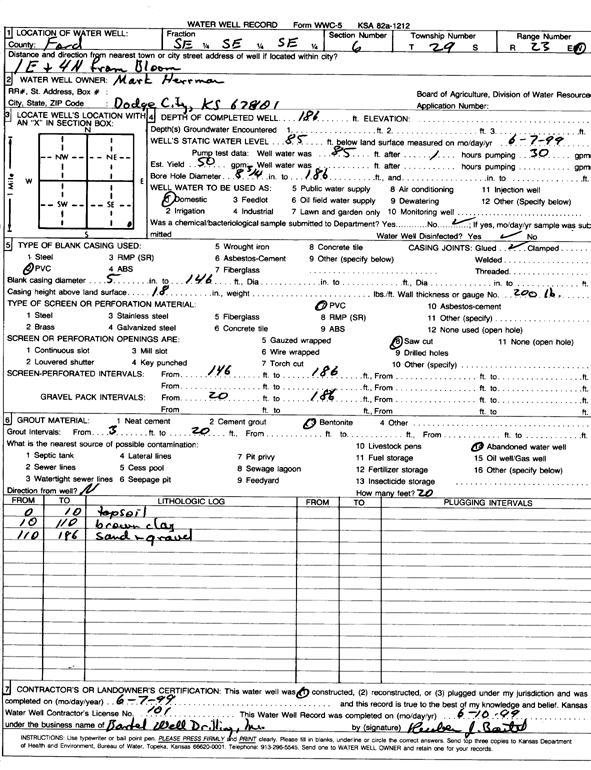
T29S, R23W, Sec. 6 SE SE SE |
Herrman, Mark | 186 ft. | 85 ft. | 50 gpm. | Domestic | Constructed | 07-Jun-1999 | Scan | |
|
T29S, R23W, Sec. 6 NE NE NE NW |
Swonger, Robert | 224 ft. | 120 ft. | Domestic | Constructed | 08-Dec-2021 | |||
|
T29S, R23W, Sec. 7 SE SE SW |
Clowdis, Del | 230 ft. | 181 ft. | 20 gpm. | Domestic | Constructed | 18-Aug-1989 | ||
|
T29S, R23W, Sec. 7 NE NW SE SW |
Schlichting, Karl (was Vincent Oil) | 208 ft. | 99 ft. | Domestic, changed from Oil Field Water Supply | Constructed | 26-Mar-2011 | |||
|
T29S, R23W, Sec. 8 SW SW SW SW |
Imel, Kevin | 255 ft. | 155 ft. | 50 gpm. | Domestic, Livestock | Constructed | 28-Oct-2010 | ||
|
T29S, R23W, Sec. 8 SE |
Robinson, Johnna | 238 ft. | 127 ft. | 50 gpm. | Domestic, Livestock | Constructed | 19-Apr-2009 | ||
|
T29S, R23W, Sec. 8 SW NW SE |
Weddle, Terry | 209 ft. | 89.4 ft. | 30 gpm. | Domestic, Livestock | Constructed | 07-Jul-1977 | ||
|
T29S, R23W, Sec. 9 NW NW NW |
Helen Hitz Trust | 225 ft. | 114 ft. | Domestic | Constructed | 12-May-1993 | |||
|
T29S, R23W, Sec. 9 SW SW NE |
Hitz, Glen | 260 ft. | 185 ft. | Domestic, Livestock | Constructed | 13-Jul-1977 | |||
|
T29S, R23W, Sec. 9 SW SW NE |
Hitz, Glen | 240 ft. | 178 ft. | 10 gpm. | Domestic, Livestock | Constructed | 13-Jul-1977 | ||
|
T29S, R23W, Sec. 10 NW NW NE |
Minor, Clifford | 277 ft. | 161 ft. | 2000 gpm. | Irrigation | Constructed | 20-Aug-1981 | ||
|
T29S, R23W, Sec. 10 SW SE NE SW |
Torline, Kelly | 280 ft. | 185 ft. | 40 gpm. | Domestic, Livestock | Constructed | 05-May-2020 | ||
|
T29S, R23W, Sec. 10 NE NW NE |
Vincent Oil Corp. | 290 ft. | 161 ft. | Oil Field Water Supply | Torline 1-10 | Constructed | 08-Aug-2019 | ||
|
T29S, R23W, Sec. 11 SE SE NW |
Vincent Oil Corp. | 290 ft. | 154 ft. | Oil Field Water Supply | White 1-11 | Constructed | 23-Jan-2020 | ||
|
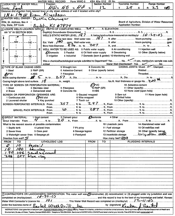
T29S, R23W, Sec. 12 NW NE NW |
Clevenger, Dustin | 297 ft. | 187 ft. | 100 gpm. | Domestic | Constructed | 30-Oct-2003 | Scan | |
|
T29S, R23W, Sec. 13 SW NE SE |
Cummings, Gary (was Vincent Oil) | 230 ft. | 166 ft. | Domestic, changed from Oil Field Water Supply | Constructed | 20-Oct-2010 | |||
|
T29S, R23W, Sec. 13 C SW |
Pickrell Drilling Co. | 200 ft. | 136 ft. | Oil Field Water Supply | Constructed | 18-Jul-1980 | |||
|
T29S, R23W, Sec. 13 SW NE SE |
Scott, Wilber | 220 ft. | 120 ft. | 2000 gpm. | Irrigation | Constructed | 30-Oct-1975 | ||
|
T29S, R23W, Sec. 15 SW SW SW |
Hill, Marjorie | 194 ft. | Domestic | Plugged | 28-Aug-1997 | ||||
|
T29S, R23W, Sec. 15 NE NE SE |
Wessel, John | 270 ft. | 160 ft. | 35 gpm. | Domestic | Constructed | 03-Jul-1989 | ||
|
T29S, R23W, Sec. 16 C E2 SE |
Ford County Land and Cattle Co | 330 ft. | 211 ft. | Irrigation | Constructed | 20-Apr-2001 | Scan | ||
|
T29S, R23W, Sec. 16 SE SE SW |
Hill, Bob | 318 ft. | 195 ft. | 30 gpm. | Domestic | Constructed | 18-Dec-1985 | ||
|
T29S, R23W, Sec. 17 NW SW SE |
Weddle, Leonard | 246 ft. | 148 ft. | 50 gpm. | Domestic, Livestock | Constructed | 27-Mar-1978 | ||
|
T29S, R23W, Sec. 18 SE NE NE |
Hill, M M | 256 ft. | 140 ft. | 50 gpm. | Domestic | Constructed | 19-May-1993 | ||
|
T29S, R23W, Sec. 18 SE SE NE |
Hill, M M | 136 ft. | 126 ft. | Domestic | Plugged | 19-May-1993 | |||
|
T29S, R23W, Sec. 19 SE NE NW |
Birney, Carl | 250 ft. | 170 ft. | Feedlot/Livestock/Windmill | Plugged | 15-Oct-2010 | |||
|
T29S, R23W, Sec. 19 NE NE NE SW |
Birney, Carl | 260 ft. | 164 ft. | 50 gpm. | Domestic, Livestock | Constructed | 26-Nov-2010 | ||
|
T29S, R23W, Sec. 19 SE NE NW |
Birney, Carl | 250 ft. | 170 ft. | Feedlot/Livestock/Windmill | Constructed | 15-Oct-2010 | |||
|
T29S, R23W, Sec. 19 NE NE NE |
Spradlin, Jim | 240 ft. | 182 ft. | 40 gpm. | Domestic | Constructed | 08-Jun-2006 | ||
|
T29S, R23W, Sec. 21 NW SW SE |
Stimpert, Barry | 292 ft. | 200 ft. | Irrigation | Constructed | 29-Oct-1982 | |||
|
T29S, R23W, Sec. 23 SE SE SE |
Ellis, Gilbert | 205 ft. | 105 ft. | Domestic | Constructed | 12-Sep-1993 | |||
|
T29S, R23W, Sec. 25 NW SW SW |
Chavez, Angie | 240 ft. | 186 ft. | Domestic | Constructed | 25-Dec-1996 | |||
|
T29S, R23W, Sec. 25 NW SW SW |
White, Kenneth | 180 ft. | 142 ft. | 15 gpm. | Domestic, Livestock | Constructed | 21-Dec-1977 | ||
|
T29S, R23W, Sec. 26 NE NE SE |
White, Hal | 250 ft. | 167 ft. | Domestic | Constructed | 27-Sep-2004 | |||
|
T29S, R23W, Sec. 26 NE NE SE |
White, Hal | 178 ft. | 166 ft. | Domestic | Plugged | 21-May-2005 | |||
|
T29S, R23W, Sec. 27 SE SE SE |
Bailey, Mary | 240 ft. | 174 ft. | 25 gpm. | Domestic | Constructed | 05-Sep-1980 | ||
|
T29S, R23W, Sec. 27 NW NW NW |
Bailey, Mary | 220 ft. | 178 ft. | 25 gpm. | Domestic, Livestock | Constructed | 15-Dec-1980 | ||
|
T29S, R23W, Sec. 28 NE NE NW |
Brown, George | 240 ft. | 180 ft. | 35 gpm. | Domestic | Constructed | 16-Aug-1978 | ||
|
T29S, R23W, Sec. 29 NW NW NW |
Imel, Kevin | 268 ft. | 192 ft. | 10 gpm. | Domestic | Constructed | 24-Jul-2013 | ||
|
T29S, R23W, Sec. 29 NW NW NE |
Smith, Dennis | 290 ft. | 205 ft. | 20 gpm. | Domestic | Constructed | 14-Aug-1989 | ||
|
T29S, R23W, Sec. 30 SE NE NE |
Liles, Loren | 260 ft. | 185 ft. | 40 gpm. | Domestic | Constructed | 31-Dec-1996 | ||
|
T29S, R23W, Sec. 33 SW SE SE |
Birney, Raymond | 238 ft. | 162 ft. | 40 gpm. | Domestic | Constructed | 18-Jun-2004 | ||
|
T29S, R23W, Sec. 33 NW NE SE |
Esplund, Gary | 200 ft. | 180 ft. | 5 gpm. | Domestic | Constructed | 28-Feb-1992 | Scan | |
|
T29S, R23W, Sec. 34 NW NW NW |
Bailey, Mary | 140 ft. | 87 ft. | Domestic | Constructed | 21-Jul-1989 | |||
|
T29S, R23W, Sec. 34 NW NW NW |
Bailey, Mary | 90 ft. | 87 ft. | Domestic | Plugged | 21-Jul-1989 | |||
|
T29S, R23W, Sec. 36 NW NE NE |
Couch, Harry | 160 ft. | 128 ft. | 10 gpm. | Domestic | Constructed | 28-Mar-1976 | ||
|
T29S, R24W, Sec. 2 NW SE SE SE |
Clark, Charles | 287 ft. | 171 ft. | 50 gpm. | Domestic | Constructed | 29-Mar-2014 |
KOLAR |
|
| View page: < Prev || 91 || 92 || 93 || 94 || 95 || 96 || 97 || 98 || 99 | |||||||||