Select location of well to view details.
Click on column heading to sort.
|
|
|
County: Franklin Select location of well to view details. Click on column heading to sort. |
|
|
|
| View page: < Prev || 11 || 12 || 13 || 14 || 15 || 16 || 17 || 18 || 19 || 20 || Next > | |||||||||
| T-R-S | Owner | Well Depth Ascend. Desc. |
Static Water Level Ascend. Desc. |
Est. Yield Ascend. Desc. |
Well Use | Other ID | Action Taken | Completion Date Ascend. Desc. |
Scan? |
|
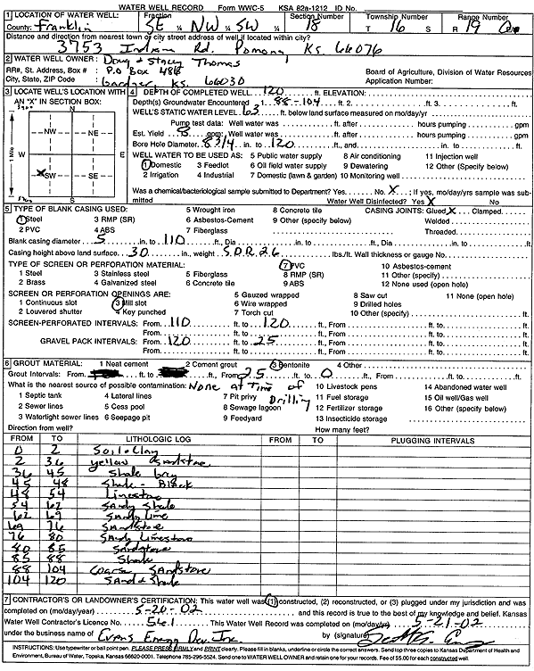
T16S, R19E, Sec. 18 SE NW SW |
Thomas, Doug and Stacey | 120 ft. | 63 ft. | 8 gpm. | Domestic | Constructed | 20-May-2002 | Scan | |
|
T16S, R19E, Sec. 18 NW SW SW NW |
Watts, Charlie | 100 ft. | 24 ft. | 15 gpm. | Domestic | Constructed | 22-May-2001 | ||
|
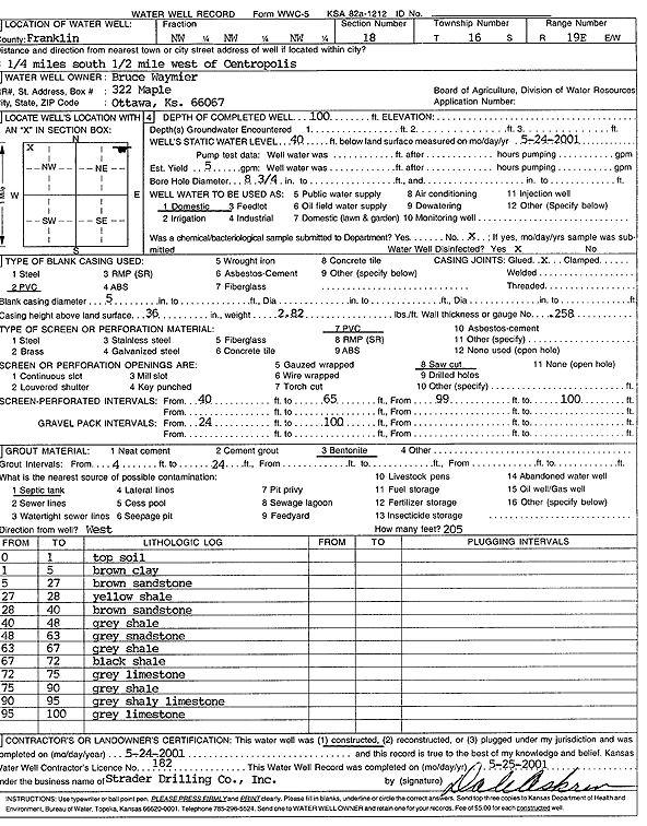
T16S, R19E, Sec. 18 NW NW NW |
Waymier, Bruce | 100 ft. | 40 ft. | Domestic | Constructed | 24-May-2001 | Scan | ||
|
T16S, R19E, Sec. 18 SE SE NW |
Williamson, Jim | 65 ft. | 30 ft. | 30 gpm. | Domestic | Constructed | 12-Jul-1990 | ||
|
T16S, R19E, Sec. 19 NE NW NW |
Hogelin, Gary | 100 ft. | 30 ft. | 6 gpm. | Domestic | Constructed | 22-Nov-1976 | ||
|
T16S, R19E, Sec. 19 NE NW NW |
Hutchinson, Mary Jo | 135 ft. | .5 gpm. | Geothermal, Closed Loop, Vertical | Constructed | 06-Nov-1997 | |||
|
T16S, R19E, Sec. 19 SW SW NW |
Rumford, Raymond | 135 ft. | 17 ft. | Domestic | Plugged | 05-Jan-2011 | |||
|
T16S, R19E, Sec. 20 NW NE SE |
Harrel, Jerry | 60 ft. | 15 ft. | Domestic | Constructed | 08-May-1978 | |||
|
T16S, R19E, Sec. 21 NW NW |
Bridges, C.H. | 85 ft. | Domestic | Constructed | 01-Jan-1981 | ||||
|
T16S, R19E, Sec. 21 SE |
Harrell, Jerald | 60 ft. | 50 ft. | Domestic | Plugged | 13-Feb-2009 | |||
|
T16S, R19E, Sec. 21 SW NW NW |
Kaub, Fred | 124 ft. | 60 ft. | 2 gpm. | Domestic | Constructed | 14-Jan-1976 | ||
|
T16S, R19E, Sec. 23 SE SE SW |
Dennis, L. A. | 167 ft. | Domestic | Constructed | 23-Apr-1950 | ||||
|
T16S, R19E, Sec. 24 NE SE SE SE |
COF Services | 190 ft. | 0 gpm. | Domestic, Lawn and Garden | Plugged | 06-Jun-2013 |
KOLAR |
||
|
T16S, R19E, Sec. 24 SW NW |
Franklin Sales Barn | 60 ft. | 6 ft. | 12 gpm. | Domestic | Constructed | 05-Apr-1962 | ||
|
T16S, R19E, Sec. 24 SE SW |
Heathman, Fred | 165 ft. | Domestic | Plugged | 19-Jul-1976 | ||||
|
T16S, R19E, Sec. 24 NW NE SE |
Rumford, Raymond | Domestic | Plugged | 22-Dec-1995 | |||||
|
T16S, R19E, Sec. 24 SW NE SE |
Rumford, Raymond | 100 ft. | Domestic | Plugged | 02-Jan-1996 | ||||
|
T16S, R19E, Sec. 25 NE SE SE |
D & D Development, Inc. | 35 ft. | 20 ft. | Dewatering | Plugged | 24-Nov-1997 | |||
|
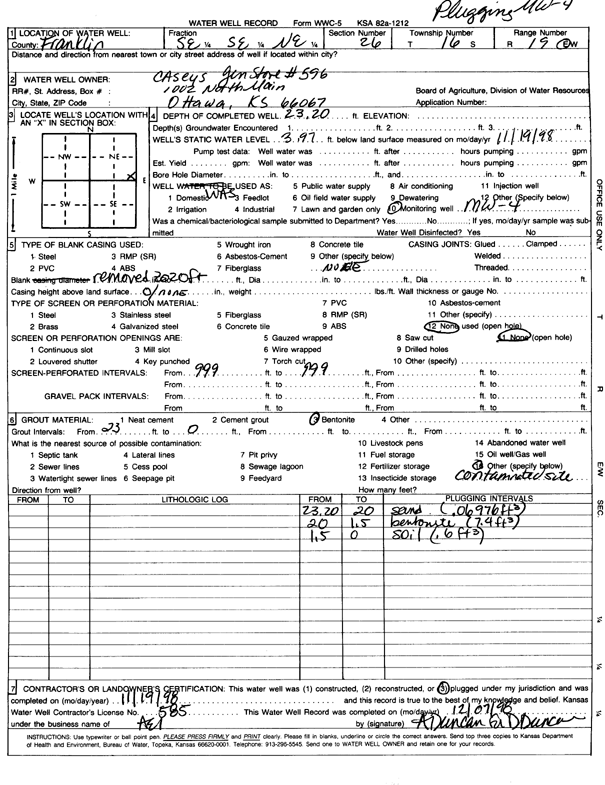
T16S, R19E, Sec. 26 SE SE NE |
Casey's General Store | 23.2 ft. | 3.97 ft. | Monitoring well/observation/piezometer | MW 4 | Plugged | 19-Nov-1998 | Scan | |
|
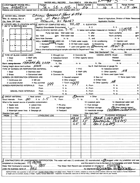
T16S, R19E, Sec. 26 SE SE NE |
Casey's General Store | 23.1 ft. | 3.45 ft. | Monitoring well/observation/piezometer | MW 3 | Plugged | 18-Nov-1998 | Scan | |
|
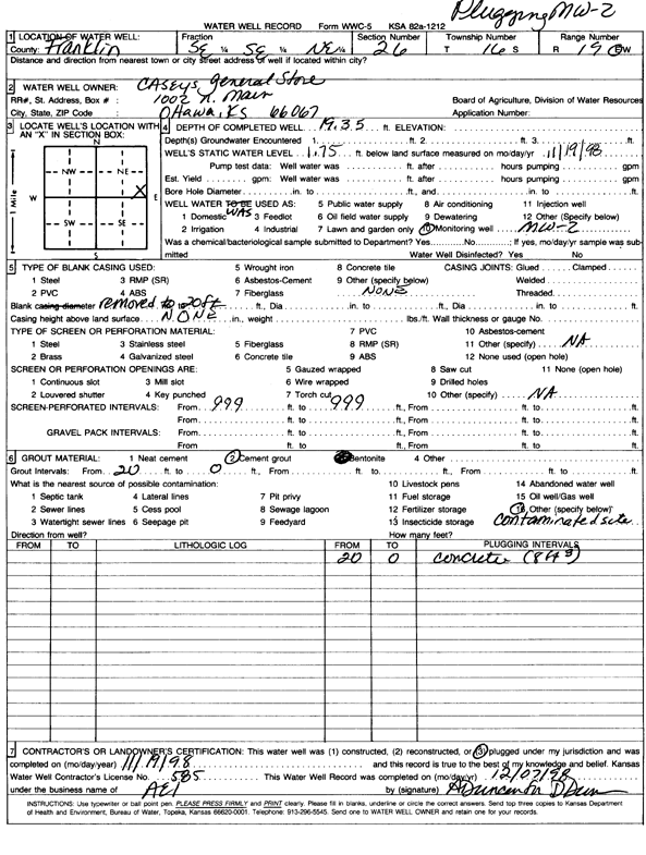
T16S, R19E, Sec. 26 SE SE NE |
Casey's General Store | 19.3 ft. | 1.75 ft. | Monitoring well/observation/piezometer | MW 2 | Plugged | 19-Nov-1998 | Scan | |
|
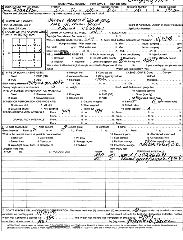
T16S, R19E, Sec. 26 SE SE NE |
Casey's General Store | 24.7 ft. | 2.04 ft. | Monitoring well/observation/piezometer | MW 1 | Plugged | 19-Nov-1998 | Scan | |
|
T16S, R19E, Sec. 26 SE SE SE |
Dick Martin Property | 7.5 ft. | 4.25 ft. | Monitoring well/observation/piezometer | MW 1 | Constructed | 04-Jun-1997 | ||
|
T16S, R19E, Sec. 26 SE SE SE |
Dick Martin Property | 8.5 ft. | 4.47 ft. | Monitoring well/observation/piezometer | MW 1 | Plugged | 02-Sep-2004 | ||
|
T16S, R19E, Sec. 26 NE SW NW |
James Earl Sink Trust | 20 ft. | 4 ft. | (unstated)/abandoned | Plugged | 04-Nov-2016 | |||
|
T16S, R19E, Sec. 26 NE NE NE |
KDHE (Baxter Oil) | 20 ft. | 5.7 ft. | Monitoring well/observation/piezometer | MW 17 | Constructed | 04-Aug-2011 | ||
|
T16S, R19E, Sec. 26 SW SE NW |
Peperson, Carl | 58 ft. | 18 ft. | 1.5 gpm. | Domestic | Constructed | 23-Aug-1979 | ||
|
T16S, R19E, Sec. 27 SW SW NW |
O'Conner, Ken | 40 ft. | 20 ft. | Domestic | Plugged | 07-Aug-1992 | |||
|
T16S, R19E, Sec. 27 NW SW NW |
O'Connor, Ken | 60 ft. | 20 ft. | 8 gpm. | Domestic | Constructed | 19-Aug-1979 | ||
|
T16S, R19E, Sec. 27 SW SW NW |
O'Connor, Ken | 42 ft. | 20 ft. | 20 gpm. | Domestic | Constructed | 07-Aug-1992 | ||
|
T16S, R19E, Sec. 29 SW NW SW |
Beauchamp, Jack E. and Lyndell J. | 30 ft. | 60 ft. | Industrial | Plugged | 10-Sep-1999 | Scan | ||
|
T16S, R19E, Sec. 29 SE SE SW |
Peterson, Carl | 58 ft. | 15 ft. | 3 gpm. | Domestic | Constructed | 02-Oct-1979 | ||
|
T16S, R19E, Sec. 30 SW SE NE |
Beauchamp, Jake E. and Lyndell J. | 20 ft. | 15 ft. | Domestic, Livestock | Plugged | 01-Sep-1999 | Scan | ||
|
T16S, R19E, Sec. 30 SW SE NW |
Brioke, Mark | 140 ft. | 70 ft. | 3 gpm. | Domestic | Constructed | 06-Apr-2007 | ||
|
T16S, R19E, Sec. 30 SW SW SW SW |
Buffalo Ranch | 140 ft. | 80 ft. | 20 gpm. | Domestic, Livestock | Constructed | 07-Apr-2014 |
KOLAR |
|
|
T16S, R19E, Sec. 30 NE NE NW NW |
Lingo, Dora | 240 ft. | 20 ft. | 3.5 gpm. | Domestic | Constructed | 22-Oct-2012 |
KOLAR |
|
|
T16S, R19E, Sec. 30 NE NE NW |
Sullivan, Tim | 170 ft. | 80 ft. | 15 gpm. | Domestic | Constructed | 10-Aug-2005 | ||
|
T16S, R19E, Sec. 31 NW NW SW |
BNSF Railway Co. | 50 ft. | Monitoring well/observation/piezometer | MW 3 | Constructed | 10-Jan-2009 | |||
|
T16S, R19E, Sec. 31 NE NE SE |
BNSF Railway Co. | 45 ft. | Monitoring well/observation/piezometer | MW 2 | Constructed | 12-Jan-2009 | |||
|
T16S, R19E, Sec. 31 NW NW SW |
BNSF Railway Co. | 50 ft. | Monitoring well/observation/piezometer | MW 4 | Constructed | 11-Jan-2009 | |||
|
T16S, R19E, Sec. 31 NW NW SW |
BNSF Railway Co. | 77 ft. | Monitoring well/observation/piezometer | MW 1 | Plugged | 06-Apr-2015 | |||
|
T16S, R19E, Sec. 31 NW NW SW |
BNSF Railway Co. | 50 ft. | Monitoring well/observation/piezometer | MW 3 | Plugged | 06-Apr-2015 | |||
|
T16S, R19E, Sec. 31 NW NW SW |
BNSF Railway Co. | 50 ft. | Monitoring well/observation/piezometer | MW 4 | Plugged | 06-Apr-2015 | |||
|
T16S, R19E, Sec. 31 NW NW SW |
BNSF Railway Co. | 12 ft. | Monitoring well/observation/piezometer | PZ 111 | Plugged | 06-Apr-2015 | |||
|
T16S, R19E, Sec. 31 NW NW SW |
BNSF Railway Co. | 12 ft. | Monitoring well/observation/piezometer | PZ 110 | Plugged | 06-Apr-2015 | |||
|
T16S, R19E, Sec. 31 NW NW SW |
BNSF Railway Co. | 77 ft. | Monitoring well/observation/piezometer | MW 1 | Constructed | 09-Jan-2009 | |||
|
T16S, R19E, Sec. 31 SW SE SW |
Dixon, John | 125 ft. | 20 ft. | 2.5 gpm. | Domestic | Constructed | 04-Jun-1991 | ||
|
T16S, R19E, Sec. 31 NW NW NW NW |
Johnson, Don | 138 ft. | 35 ft. | 30 gpm. | Domestic | Constructed | 05-Jul-2020 |
KOLAR |
|
|
T16S, R19E, Sec. 31 NW NW NW NW |
Johnson, Don | 32 ft. | 29 ft. | Domestic | Plugged | 24-Sep-2020 | |||
|
T16S, R19E, Sec. 32 NW NW SW |
Elliott, Marry | 58 ft. | 15 ft. | 4 gpm. | Domestic | Constructed | 24-Sep-1979 | ||
| View page: < Prev || 11 || 12 || 13 || 14 || 15 || 16 || 17 || 18 || 19 || 20 || Next > | |||||||||