Select location of well to view details.
Click on column heading to sort.
|
|
|
County: Franklin Select location of well to view details. Click on column heading to sort. |
|
|
|
| View page: < Prev || 11 || 12 || 13 || 14 || 15 || 16 || 17 || 18 || 19 || 20 || Next > | |||||||||
| T-R-S | Owner | Well Depth Ascend. Desc. |
Static Water Level Ascend. Desc. |
Est. Yield Ascend. Desc. |
Well Use | Other ID | Action Taken | Completion Date Ascend. Desc. |
Scan? |
|
T16S, R19E, Sec. 32 NW NW SW |
Kiefer, Ben | 78 ft. | 5 ft. | 15 gpm. | Domestic | Constructed | 15-Oct-1979 | ||
|
T16S, R19E, Sec. 34 SW SW SW |
Barnett, Floyd | 102 ft. | Domestic | Constructed | 01-Jun-1954 | ||||
|
T16S, R19E, Sec. 34 NE NE SE |
Mikte, Lyle | 95 ft. | 25 ft. | 12 gpm. | Domestic | Constructed | 04-Aug-1989 | ||
|
T16S, R19E, Sec. 34 SE SE SE |
Sitlington, George | 94 ft. | 55 ft. | 28 gpm. | Domestic | Constructed | 27-Feb-1990 | ||
|
T16S, R19E, Sec. 35 NE SE NE |
Bennett Creamery | 886 ft. | Domestic | Constructed | 01-Oct-1955 | ||||
|
T16S, R19E, Sec. 35 NE NE SW |
City of Ottawa | 17 ft. | 7.27 ft. | Monitoring well/observation/piezometer | MW 5 | Constructed | 04-Jun-1998 | ||
|
T16S, R19E, Sec. 35 NE NE SW |
City of Ottawa | 14.5 ft. | 10 ft. | Monitoring well/observation/piezometer | MW 4 | Plugged | 08-Aug-2000 | Scan | |
|
T16S, R19E, Sec. 35 NE NE SW |
City of Ottawa | 22 ft. | 11.4 ft. | Monitoring well/observation/piezometer | MW 3 | Constructed | 04-Jun-1998 | ||
|
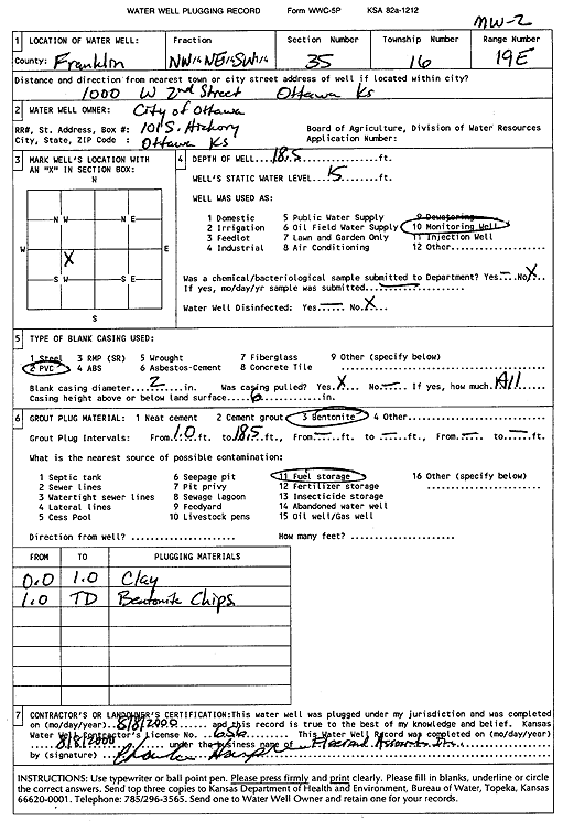
T16S, R19E, Sec. 35 NW NE SW |
City of Ottawa | 18.5 ft. | 15 ft. | Monitoring well/observation/piezometer | MW 2 | Plugged | 08-Aug-2000 | Scan | |
|
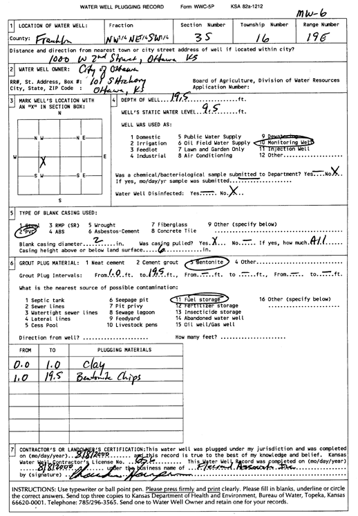
T16S, R19E, Sec. 35 NE NE SW |
City of Ottawa | 19.5 ft. | 8.19 ft. | Monitoring well/observation/piezometer | MW 6 | Constructed | 04-Jun-1998 | ||
|
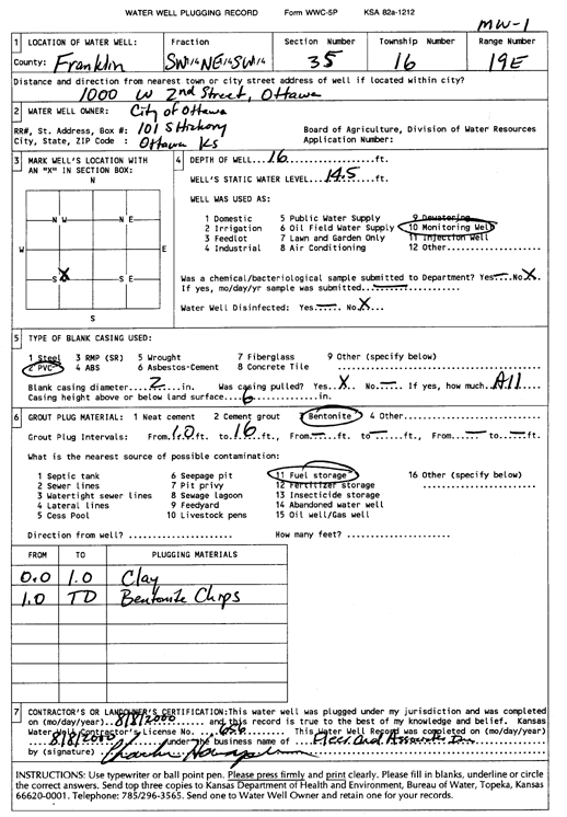
T16S, R19E, Sec. 35 NE NE SW |
City of Ottawa | 16 ft. | 8.52 ft. | Monitoring well/observation/piezometer | MW 1 | Constructed | 04-Jun-1998 | ||
|
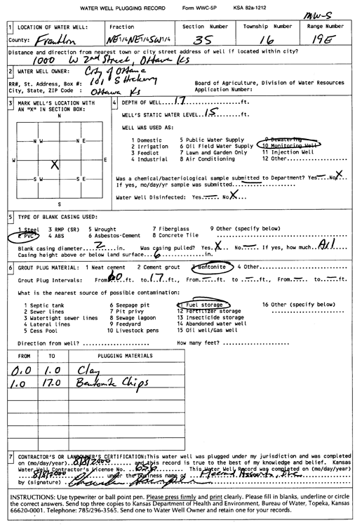
T16S, R19E, Sec. 35 NE NE SW |
City of Ottawa | 14.5 ft. | 4.69 ft. | Monitoring well/observation/piezometer | MW 4 | Constructed | 04-Jun-1998 | ||
|
T16S, R19E, Sec. 35 NE NE SW |
City of Ottawa | 17 ft. | 15 ft. | Monitoring well/observation/piezometer | MW 5 | Plugged | 08-Aug-2000 | Scan | |
|
T16S, R19E, Sec. 35 SW NE SW |
City of Ottawa | 16 ft. | 14.5 ft. | Monitoring well/observation/piezometer | MW 1 | Plugged | 08-Aug-2000 | Scan | |
|
T16S, R19E, Sec. 35 NW NE SW |
City of Ottawa | 19.5 ft. | 9.5 ft. | Monitoring well/observation/piezometer | MW 6 | Plugged | 08-Aug-2000 | Scan | |
|
T16S, R19E, Sec. 35 NW NE SW |
City of Ottawa | 22 ft. | 11.4 ft. | Monitoring well/observation/piezometer | MW 3 | Plugged | 08-Aug-2000 | Scan | |
|
T16S, R19E, Sec. 35 NE NE SW |
City of Ottawa | 18.5 ft. | 7.93 ft. | Monitoring well/observation/piezometer | MW 2 | Constructed | 04-Jun-1998 | ||
|
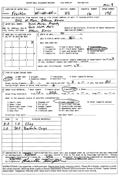
T16S, R19E, Sec. 35 NE NE NE |
Dick Martin Properties | 20 ft. | 3.51 ft. | Monitoring well/observation/piezometer | MW 9 | Plugged | 08-Aug-2000 | Scan | |
|
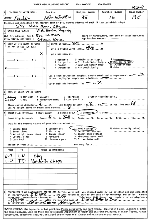
T16S, R19E, Sec. 35 NE NE NE |
Dick Martin Property | 12.5 ft. | 3.41 ft. | Monitoring well/observation/piezometer | MW 4 | Plugged | 02-Sep-2004 | ||
|
T16S, R19E, Sec. 35 NE NE NE |
Dick Martin Property | 18.5 ft. | 3.07 ft. | Monitoring well/observation/piezometer | MW 2 | Plugged | 02-Sep-2004 | ||
|
T16S, R19E, Sec. 35 NE NE NE |
Dick Martin Property | 19 ft. | 3.82 ft. | Monitoring well/observation/piezometer | MW 5 | Plugged | 02-Sep-2004 | ||
|
T16S, R19E, Sec. 35 NE NE NE |
Dick Martin Property | 25 ft. | 4.29 ft. | Monitoring well/observation/piezometer | MW 7 | Constructed | 04-Jun-1997 | ||
|
T16S, R19E, Sec. 35 NE NE NE |
Dick Martin Property | 25 ft. | 3.43 ft. | Monitoring well/observation/piezometer | MW 5 | Constructed | 04-Jun-1997 | ||
|
T16S, R19E, Sec. 35 NE NE NE |
Dick Martin Property | 17.5 ft. | 2.65 ft. | Monitoring well/observation/piezometer | MW 2 | Constructed | 04-Jun-1997 | ||
|
T16S, R19E, Sec. 35 NE NE NE |
Dick Martin Property | 20 ft. | 3.49 ft. | Monitoring well/observation/piezometer | MW 9 | Constructed | 19-Dec-1997 | ||
|
T16S, R19E, Sec. 35 NE NE NE |
Dick Martin Property | 25.5 ft. | 4.85 ft. | Monitoring well/observation/piezometer | MW 7 | Plugged | 02-Sep-2004 | ||
|
T16S, R19E, Sec. 35 NE NE NE |
Dick Martin Property | 30 ft. | 5.46 ft. | Monitoring well/observation/piezometer | MW 3 | Constructed | 04-Jun-1997 | ||
|
T16S, R19E, Sec. 35 NE NE NE |
Dick Martin Property | 12.5 ft. | 3.25 ft. | Monitoring well/observation/piezometer | MW 4 | Constructed | 04-Jun-1997 | ||
|
T16S, R19E, Sec. 35 NE NE NE |
Dick Martin Property | 20 ft. | 14.5 ft. | Monitoring well/observation/piezometer | MW 8 | Plugged | 08-Aug-2000 | Scan | |
|
T16S, R19E, Sec. 35 NE NE NE |
Dick Martin Property | 31.5 ft. | 6.29 ft. | Monitoring well/observation/piezometer | MW 3 | Plugged | 02-Sep-2004 | ||
|
T16S, R19E, Sec. 35 NE NE NE |
Dick Martin Property | 20 ft. | 3.42 ft. | Monitoring well/observation/piezometer | MW 8 | Constructed | 04-Jun-1997 | ||
|
T16S, R19E, Sec. 35 SE NE NE |
Franklin County Courthouse | 450 ft. | Air Conditioning | Constructed | 31-Aug-2012 | ||||
|
T16S, R19E, Sec. 35 NE NE NE |
KDHE (Baxter Oil) | 13.5 ft. | 3.27 ft. | Monitoring well/observation/piezometer | MW 16 | Constructed | 21-Feb-2011 | ||
|
T16S, R19E, Sec. 35 NE NE NE |
KDHE (Baxter Oil) | 13.5 ft. | 2.7 ft. | Monitoring well/observation/piezometer | MW 15 | Constructed | 21-Feb-2011 | ||
|
T16S, R19E, Sec. 35 NE NE NE |
KDHE (Baxter Oil) | 14.8 ft. | 4 ft. | Monitoring well/observation/piezometer | MW 12 | Constructed | 19-Jul-2010 | ||
|
T16S, R19E, Sec. 35 NE NE NE |
KDHE (Baxter Oil) | 14.8 ft. | 4.3 ft. | Monitoring well/observation/piezometer | MW 13 | Constructed | 19-Jul-2010 | ||
|
T16S, R19E, Sec. 35 SE SE NE NE |
KDHE (Jim Bass Electric) | 25 ft. | 9.4 ft. | Monitoring well/observation/piezometer | MW 11 | Constructed | 20-Jun-2022 | ||
|
T16S, R19E, Sec. 35 SE SE NE NE |
KDHE (Jim Bass Electric) | 25 ft. | 9.69 ft. | Monitoring well/observation/piezometer | MW 3 R | Constructed | 20-Jun-2022 | ||
|
T16S, R19E, Sec. 35 SW SW SE |
Scott, Milton | 15 ft. | Domestic | Plugged | 04-May-1996 | ||||
|
T16S, R19E, Sec. 36 SW NW SW |
Heidner, B. F. | 85 ft. | 12 ft. | 20 gpm. | Domestic | Constructed | 15-Feb-1963 | ||
|
T16S, R19E, Sec. 36 SW NW NW |
Jim Bass Electric | 24 ft. | Monitoring well/observation/piezometer | MW 7 | Constructed | 26-Feb-1995 | |||
|
T16S, R19E, Sec. 36 SW NW NW |
Jim Bass Electric | 24 ft. | 14.18 ft. | Monitoring well/observation/piezometer | MW 2 | Constructed | 25-Feb-1995 | ||
|
T16S, R19E, Sec. 36 SW NW NW |
Jim Bass Electric | 24 ft. | 13.86 ft. | Monitoring well/observation/piezometer | MW 5 | Constructed | 26-Feb-1995 | ||
|
T16S, R19E, Sec. 36 SW NW NW |
Jim Bass Electric | 24 ft. | 14.7 ft. | Monitoring well/observation/piezometer | MW 6 | Constructed | 25-Feb-1995 | ||
|
T16S, R19E, Sec. 36 SW NW NW |
Jim Bass Electric | 24 ft. | 15.07 ft. | Monitoring well/observation/piezometer | MW 8 | Constructed | 27-Feb-1995 | ||
|
T16S, R19E, Sec. 36 SW NW NW |
Jim Bass Electric | 24 ft. | 14.72 ft. | Monitoring well/observation/piezometer | MW 4 | Constructed | 26-Feb-1995 | ||
|
T16S, R19E, Sec. 36 SW NW NW |
Jim Bass Electric | 27 ft. | 13.9 ft. | Monitoring well/observation/piezometer | MW 1 | Constructed | 24-Feb-1995 | ||
|
T16S, R19E, Sec. 36 SW NW NW |
Jim Bass Electric | 24 ft. | 13.35 ft. | Monitoring well/observation/piezometer | MW 3 | Constructed | 25-Feb-1995 | ||
|
T16S, R19E, Sec. 36 NW NW NW |
KDHE (Baxter Oil) | 17.5 ft. | 7.74 ft. | Monitoring well/observation/piezometer | MW 8 | Constructed | 27-Jan-2010 | ||
|
T16S, R19E, Sec. 36 NW NW NW |
KDHE (Baxter Oil) | 18 ft. | 5.31 ft. | Monitoring well/observation/piezometer | MW 7 | Constructed | 26-Jan-2010 | ||
| View page: < Prev || 11 || 12 || 13 || 14 || 15 || 16 || 17 || 18 || 19 || 20 || Next > | |||||||||