Select location of well to view details.
Click on column heading to sort.
|
|
|
County: Franklin Select location of well to view details. Click on column heading to sort. |
|
|
|
| View page: < Prev || 21 || 22 || 23 || 24 || 25 || 26 || 27 || 28 || 29 || 30 || Next > | |||||||||
| T-R-S | Owner | Well Depth Ascend. Desc. |
Static Water Level Ascend. Desc. |
Est. Yield Ascend. Desc. |
Well Use | Other ID | Action Taken | Completion Date Ascend. Desc. |
Scan? |
|
T18S, R17E, Sec. 26 SW SW SW |
Drabik, Lemnard | 80 ft. | 28 ft. | 5 gpm. | Domestic | Constructed | 08-Mar-1978 | ||
|
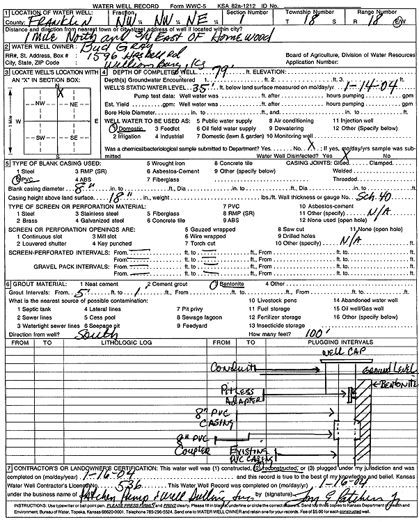
T18S, R18E, Sec. 1 NW NW NE |
Gray, Bud | 79 ft. | 35 ft. | Domestic | Reconstructed | 16-Jan-2004 | Scan | ||
|
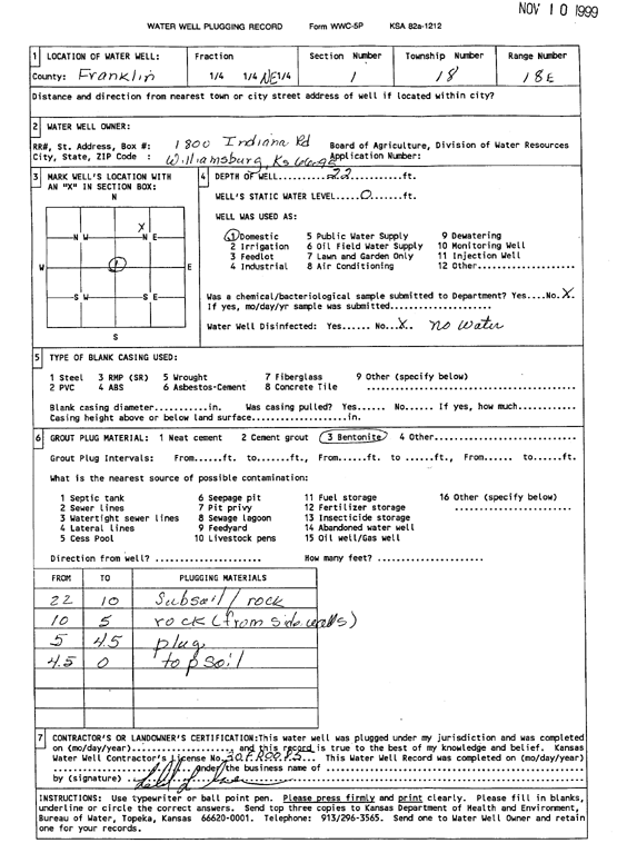
T18S, R18E, Sec. 1 NE |
22 ft. | Domestic | Plugged | 10-Oct-1999 | Scan | ||||
|
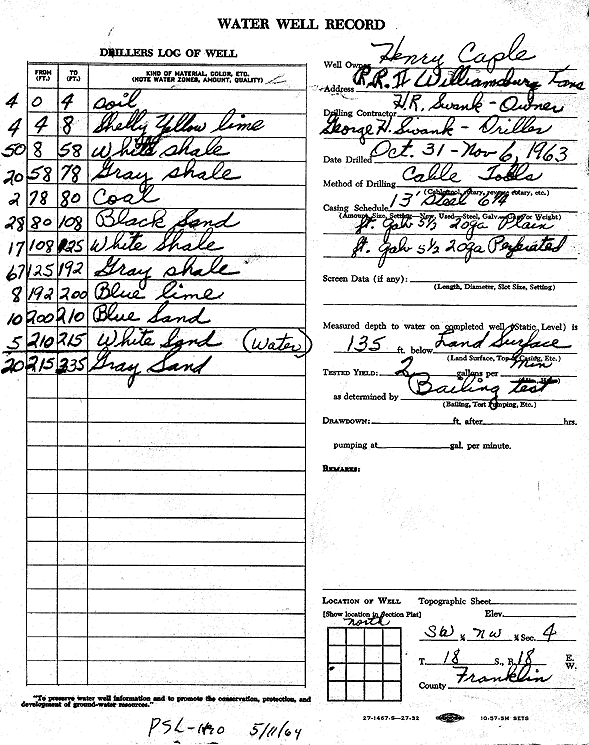
T18S, R18E, Sec. 4 SW NW |
Caple, Henry | 335 ft. | 135 ft. | 2 gpm. | Domestic | Constructed | 06-Nov-1963 | Scan | |
|
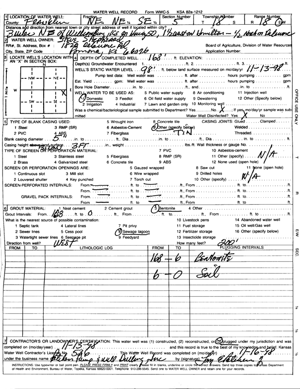
T18S, R18E, Sec. 5 NE NE SE |
Shepard, Steve | 168 ft. | 98 ft. | 4 gpm. | Domestic | Plugged | 13-Nov-1998 | Scan | |
|
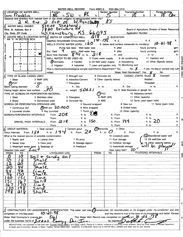
T18S, R18E, Sec. 5 NE SW NE |
Shepard, Steve | 218 ft. | 120 ft. | 4 gpm. | Domestic | Constructed | 21-Oct-1998 | Scan | |
|
T18S, R18E, Sec. 6 SE SE NW |
City of Williamsburg | 210 ft. | 99 ft. | 15 gpm. | Public Water Supply | Well 8 | Constructed | 30-Jul-1981 | |
|
T18S, R18E, Sec. 6 SW SW NE |
City of Williamsburg | 210 ft. | 99 ft. | 19 gpm. | Public Water Supply | Well 7 | Constructed | 13-Jul-1981 | |
|
T18S, R18E, Sec. 6 NE SE SW |
Kuyma, William | 215 ft. | 156 ft. | 15 gpm. | Domestic | Constructed | 17-Nov-2005 | ||
|
T18S, R18E, Sec. 7 NE NE NW |
A-1 Property Mgmt. | 250 ft. | 75 ft. | 5 gpm. | Domestic | Constructed | 06-Jul-2006 | ||
|
T18S, R18E, Sec. 7 NE NE NE |
Kindig, Grant | 124 ft. | 85 ft. | 12 gpm. | Domestic | Constructed | 28-Mar-2023 |
KOLAR |
|
|
T18S, R18E, Sec. 8 NW NW NW |
Goad, Jack | 169 ft. | 100 ft. | 9 gpm. | Domestic | Constructed | 17-Mar-1992 | ||
|
T18S, R18E, Sec. 8 NW NW SW |
Hane | 150 ft. | 80 ft. | 15 gpm. | Domestic | Constructed | 27-Apr-1988 | ||
|
T18S, R18E, Sec. 8 SE NE |
Ransom, Bill | 225 ft. | 160 ft. | 9 gpm. | (unstated)/abandoned | Constructed | 25-Jan-1964 | ||
|
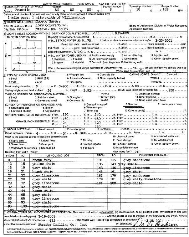
T18S, R18E, Sec. 8 SW SW SW |
Sayers, George | 200 ft. | 70 ft. | 7 gpm. | Domestic | Constructed | 19-Mar-2001 | Scan | |
|
T18S, R18E, Sec. 8 NE NW NW |
Taylor, Richard | 148 ft. | 80 ft. | 30 gpm. | Domestic, Livestock | Constructed | 11-Jun-1977 | ||
|
T18S, R18E, Sec. 10 NE SW NW NE |
ConocoPhillips | 17 ft. | Monitoring well/observation/piezometer | MW 14 | Constructed | 08-Apr-2010 | |||
|
T18S, R18E, Sec. 10 NE SW NW NE |
ConocoPhillips | 17 ft. | Monitoring well/observation/piezometer | MW 13 | Constructed | 08-Apr-2010 | |||
|
T18S, R18E, Sec. 10 NE SW NW NE |
ConocoPhillips | 18 ft. | 4.95 ft. | Monitoring well/observation/piezometer | MW 11 | Constructed | 20-Nov-2009 | ||
|
T18S, R18E, Sec. 10 NE SW NW NE |
ConocoPhillips | 12 ft. | 9.91 ft. | Monitoring well/observation/piezometer | MW 5 | Constructed | 20-Nov-2009 | ||
|
T18S, R18E, Sec. 10 NE SW NW NE |
ConocoPhillips | 12 ft. | 3.94 ft. | Monitoring well/observation/piezometer | MW 2 | Constructed | 20-Nov-2009 | ||
|
T18S, R18E, Sec. 10 NE SW NW NE |
ConocoPhillips | 12 ft. | 4.2 ft. | Monitoring well/observation/piezometer | MW 4 | Constructed | 20-Nov-2009 | ||
|
T18S, R18E, Sec. 10 NE SW NW NE |
ConocoPhillips | 12 ft. | Monitoring well/observation/piezometer | MW 12 | Constructed | 20-Nov-2009 | |||
|
T18S, R18E, Sec. 10 NE SW NW NE |
ConocoPhillips | 15 ft. | Monitoring well/observation/piezometer | RMW 8 | Constructed | 08-Apr-2010 | |||
|
T18S, R18E, Sec. 10 NE SW NW NE |
ConocoPhillips | 12 ft. | 7.06 ft. | Monitoring well/observation/piezometer | MW 1 | Constructed | 20-Nov-2009 | ||
|
T18S, R18E, Sec. 10 NE SW NW NE |
ConocoPhillips | 12 ft. | 6.05 ft. | Monitoring well/observation/piezometer | MW 3 | Constructed | 20-Nov-2009 | ||
|
T18S, R18E, Sec. 10 NE SW NW NE |
ConocoPhillips | 11 ft. | Monitoring well/observation/piezometer | MW 15 | Constructed | 08-Apr-2010 | |||
|
T18S, R18E, Sec. 10 NE SW NW NE |
ConocoPhillips | 12 ft. | 9.18 ft. | Monitoring well/observation/piezometer | MW 9 | Constructed | 20-Nov-2009 | ||
|
T18S, R18E, Sec. 10 NE SW NW NE |
ConocoPhillips | 12 ft. | 10.1 ft. | Monitoring well/observation/piezometer | MW 7 | Constructed | 20-Nov-2009 | ||
|
T18S, R18E, Sec. 10 NE SW NW NE |
ConocoPhillips | 12 ft. | 10.76 ft. | Monitoring well/observation/piezometer | MW 6 | Constructed | 20-Nov-2009 | ||
|
T18S, R18E, Sec. 10 SW NW NE |
Phillips 66 Co. | 13.21 ft. | 6.43 ft. | Monitoring well/observation/piezometer | MW 15 | Plugged | 12-Feb-2015 | ||
|
T18S, R18E, Sec. 10 SW NW NE |
Phillips 66 Co. | 19.95 ft. | 5.43 ft. | Monitoring well/observation/piezometer | MW 11 | Plugged | 23-Aug-2013 | ||
|
T18S, R18E, Sec. 10 SW NW NE |
Phillips 66 Co. | 14.77 ft. | 9.97 ft. | Monitoring well/observation/piezometer | MW 1 | Plugged | 12-Feb-2015 | ||
|
T18S, R18E, Sec. 10 SW NW NE |
Phillips 66 Co. | 21.01 ft. | 19.13 ft. | Monitoring well/observation/piezometer | MW 16 | Plugged | 12-Feb-2015 | ||
|
T18S, R18E, Sec. 10 SW NW NE |
Phillips 66 Co. | 14.7 ft. | 9.8 ft. | Monitoring well/observation/piezometer | MW 3 | Plugged | 12-Feb-2015 | ||
|
T18S, R18E, Sec. 10 SW NW NE |
Phillips 66 Co. | 14.02 ft. | Monitoring well/observation/piezometer | MW 12 | Plugged | 12-Feb-2015 | |||
|
T18S, R18E, Sec. 10 SW NW NE |
Phillips 66 Co. | 18.25 ft. | 8.62 ft. | Monitoring well/observation/piezometer | MW 8 R | Plugged | 12-Feb-2014 | ||
|
T18S, R18E, Sec. 10 SW NW NE |
Phillips 66 Co. | 11.66 ft. | 6.48 ft. | Monitoring well/observation/piezometer | MW 4 | Plugged | 12-Feb-2015 | ||
|
T18S, R18E, Sec. 10 SW NW NE |
Phillips 66 Co. | 19.6 ft. | 11.7 ft. | Monitoring well/observation/piezometer | MW 13 | Plugged | 12-Feb-2015 | ||
|
T18S, R18E, Sec. 10 SW NW NE |
Phillips 66 Co. | 15.03 ft. | 5.24 ft. | Monitoring well/observation/piezometer | MW 2 | Plugged | 12-Feb-2015 | ||
|
T18S, R18E, Sec. 10 SW NW NE |
Phillips 66 Co. | 14.63 ft. | 14.53 ft. | Monitoring well/observation/piezometer | MW 7 | Plugged | 12-Feb-2015 | ||
|
T18S, R18E, Sec. 10 SW NW NE |
Phillips 66 Co. | 13.03 ft. | 10.94 ft. | Monitoring well/observation/piezometer | MW 9 | Plugged | 12-Feb-2015 | ||
|
T18S, R18E, Sec. 10 SW NW NE |
Phillips 66 Co. | 19.18 ft. | 15.06 ft. | Monitoring well/observation/piezometer | MW 14 | Plugged | 12-Feb-2015 | ||
|
T18S, R18E, Sec. 10 SW NW NE |
Phillips 66 Co. | 14.82 ft. | 12.05 ft. | Monitoring well/observation/piezometer | MW 5 | Plugged | 12-Feb-2015 | ||
|
T18S, R18E, Sec. 10 SW NW NE |
Phillips 66 Co. | 14.51 ft. | 14 ft. | Monitoring well/observation/piezometer | MW 6 | Plugged | 12-Feb-2015 | ||
|
T18S, R18E, Sec. 10 SE SW NW NE |
Phillips 66 Co. | 18 ft. | 15.38 ft. | Monitoring well/observation/piezometer | MW 16 | Constructed | 03-Sep-2013 | ||
|
T18S, R18E, Sec. 16 NE SE SE |
Rubick, John | 310 ft. | 85 ft. | 4 gpm. | Domestic | Constructed | 21-Sep-2011 | ||
|
T18S, R18E, Sec. 19 NE NE |
Hink, William | 215 ft. | 32 ft. | 4 gpm. | (unstated)/abandoned | Constructed | 06-Mar-1961 | ||
|
T18S, R18E, Sec. 19 NW NW SW |
Stone, Eva | 38.6 ft. | 25 ft. | Domestic | Plugged | 23-Dec-1994 | |||
|
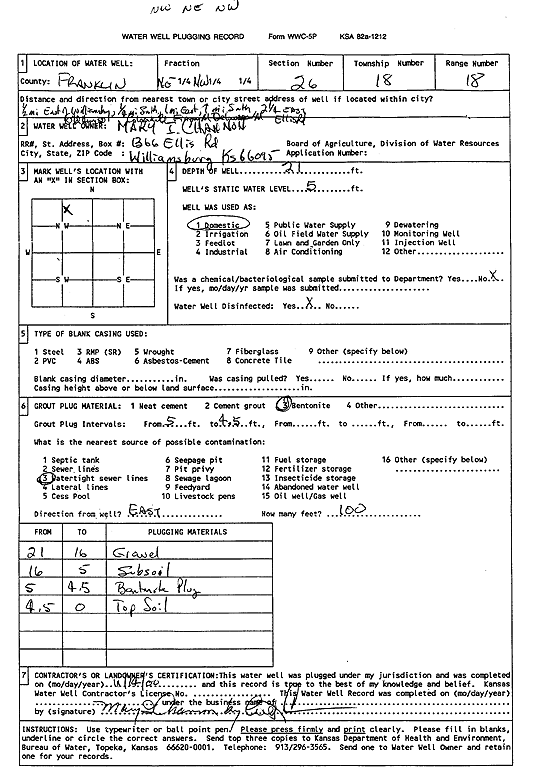
T18S, R18E, Sec. 26 NW NE NW |
Mary I. Channon | 21 ft. | 5 ft. | Domestic | Plugged | 14-Nov-2000 | Scan | ||
| View page: < Prev || 21 || 22 || 23 || 24 || 25 || 26 || 27 || 28 || 29 || 30 || Next > | |||||||||