Select location of well to view details.
Click on column heading to sort.
|
|
|
County: Graham Select location of well to view details. Click on column heading to sort. |
|
|
|
| View page: 1 || 2 || 3 || 4 || 5 || 6 || 7 || 8 || 9 || 10 || Next > | |||||||||
| T-R-S | Owner | Well Depth Ascend. Desc. |
Static Water Level Ascend. Desc. |
Est. Yield Ascend. Desc. |
Well Use | Other ID | Action Taken | Completion Date Ascend. Desc. |
Scan? |
|
T6S, R23W, Sec. 20 SW NW NW |
Shoemaker, Agnes | 100 ft. | 10 ft. | Domestic | Plugged | 26-Feb-1989 | |||
|
T6S, R23W, Sec. 21 NE SE SE |
Murfin Drilling/Morris Schaben | 120 ft. | 75 ft. | Oil Field Water Supply | Constructed | 26-Apr-1993 | |||
|
T6S, R23W, Sec. 21 S2 SE NE NW |
Rice Estate | 80 ft. | Oil Field Water Supply | Constructed | 23-Jul-2011 | ||||
|
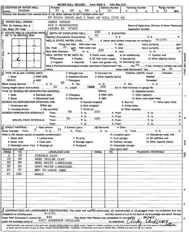
T6S, R23W, Sec. 22 SE NW SW |
Goeken, James | 100 ft. | 70 ft. | 30 gpm. | Domestic | Constructed | 01-Aug-2001 | Scan | |
|
T6S, R23W, Sec. 22 SW SE NW |
Red Tiger Drilling/Charles Morris | 102 ft. | 38 ft. | 60 gpm. | Oil Field Water Supply | Morris 1 | Constructed | 29-Mar-1984 | |
|
T6S, R23W, Sec. 23 NE SW SE |
Fountain, George | 175 ft. | 146 ft. | Domestic | Constructed | 21-Mar-1980 | |||
|
T6S, R23W, Sec. 24 SW NW NW |
Fountain, Clair | 120 ft. | 100 ft. | Domestic | Plugged | 08-Aug-1990 | |||
|
T6S, R23W, Sec. 25 SE SW SW |
Demuth, Max | 90 ft. | Domestic, Livestock | Reconstructed | 05-Apr-1989 | ||||
|
T6S, R23W, Sec. 26 SW NE NW |
Legere, Bob | 200 ft. | Oil Field Water Supply | Constructed | 12-Dec-2009 | ||||
|
T6S, R23W, Sec. 27 SW NE SE |
Fountain, Carl | 198 ft. | 132 ft. | Domestic | Constructed | 11-Nov-1981 | |||
|
T6S, R23W, Sec. 27 E2 NE |
Honas, Clarence | 200 ft. | 130 ft. | 40 gpm. | Domestic | Constructed | 02-Jun-1985 | ||
|
T6S, R23W, Sec. 27 SW NE SW |
Legere, Bob | 108 ft. | 84 ft. | Domestic, Livestock | Plugged | ||||
|
T6S, R23W, Sec. 27 E2 NW SE |
Legere, Bob | 220 ft. | Domestic | Constructed | 30-Apr-2007 | ||||
|
T6S, R23W, Sec. 28 NE NE SE |
City of Hill City | 258 ft. | 140 ft. | Monitoring well/observation/piezometer | Plugged | 23-Aug-1990 | |||
|
T6S, R23W, Sec. 28 W2 SW SE NW |
Tien, Bette (was H&C Oil Operating) | 205 ft. | Domestic, changed from Oil Field Water Supply | Tien 28-3 | Constructed | 01-Aug-2011 | |||
|
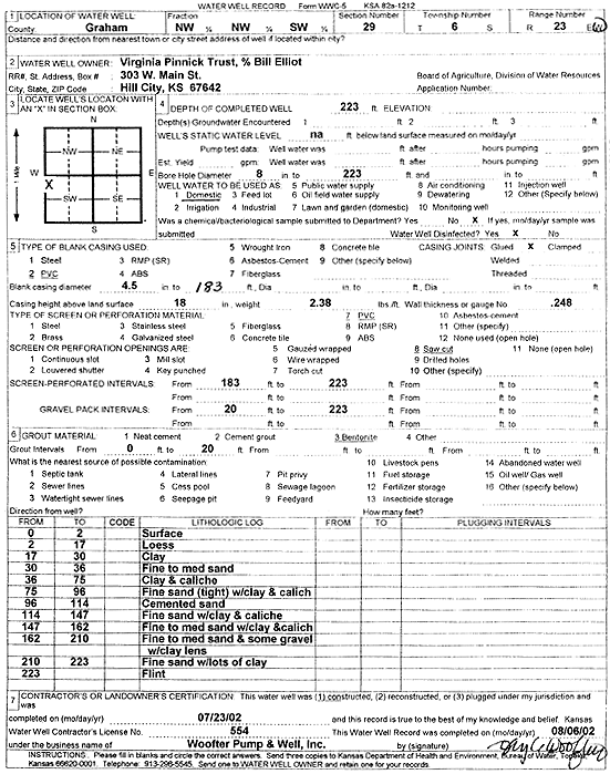
T6S, R23W, Sec. 29 NW NW SW |
Virginia Pinnick Trust | 223 ft. | Domestic | Constructed | 23-Jul-2002 | Scan | |||
|
T6S, R23W, Sec. 30 SW SE SW |
Baughman, Cleo | 150 ft. | 149 ft. | Domestic | Plugged | 09-Apr-1989 | |||
|
T6S, R23W, Sec. 30 SE NE SE |
Chenoweth, Dave | 185 ft. | 150 ft. | 35 gpm. | Domestic | Constructed | 01-Jun-2004 | ||
|
T6S, R23W, Sec. 30 NE NE SE |
City of Hill City | 255 ft. | 140 ft. | 550 gpm. | Test hole/well | Constructed | 18-Dec-1979 | ||
|
T6S, R23W, Sec. 30 NE SW SE |
Murfin Drilling Co. | 185 ft. | 90 ft. | Oil Field Water Supply | Constructed | 05-Jun-1990 | |||
|
T6S, R23W, Sec. 30 NE SW SE |
Murfin Drilling Co. | 185 ft. | 90 ft. | Oil Field Water Supply | Plugged | 15-Jun-1990 | |||
|
T6S, R23W, Sec. 30 NW SW SW |
Murfin Drilling/Cleo Baughman | 180 ft. | 134 ft. | Oil Field Water Supply | Plugged | 02-Jan-1991 | |||
|
T6S, R23W, Sec. 30 NW SW SW |
Murfin Drilling/Cleo Baughman | 180 ft. | 134 ft. | Oil Field Water Supply | Constructed | 29-Nov-1990 | |||
|
T6S, R23W, Sec. 30 NW NW NE |
Niblock, Paul | 175 ft. | Domestic, Livestock | Constructed | 31-Oct-2016 | ||||
|
T6S, R23W, Sec. 31 SE SW NE |
Murfin Drilling/Cecil Elliot | 220 ft. | 132 ft. | Oil Field Water Supply | Constructed | 09-Jul-1997 | |||
|
T6S, R23W, Sec. 31 SE SW NE |
Murfin Drilling/Cecil Elliot | 220 ft. | 132 ft. | Oil Field Water Supply | Plugged | 18-Jul-1997 | |||
|
T6S, R23W, Sec. 32 S2 SW SE |
Murfin Drilling/Gene Walters | 226 ft. | 141 ft. | Oil Field Water Supply | Constructed | 16-Mar-1996 | |||
|
T6S, R23W, Sec. 32 SW SW SW |
Murfin Drilling/Mary Walters | 240 ft. | 162 ft. | Oil Field Water Supply | Constructed | 09-May-1992 | |||
|
T6S, R23W, Sec. 32 NW NW NW |
Trexler, Alan | 243 ft. | 152 ft. | 19 gpm. | Domestic, Livestock | Constructed | 30-Sep-2009 | ||
|
T6S, R23W, Sec. 32 SE SE |
Walters, Gene | 80 ft. | Domestic | Plugged | 14-Jan-1989 | ||||
|
T6S, R23W, Sec. 33 SE NE SE |
City of Hill City | 258 ft. | 140 ft. | Public Water Supply | Reconstructed | 24-Aug-1990 | |||
|
T6S, R23W, Sec. 33 SE NE SE |
City of Hill City | 258 ft. | Monitoring well/observation/piezometer | Plugged | 23-Aug-1990 | ||||
|
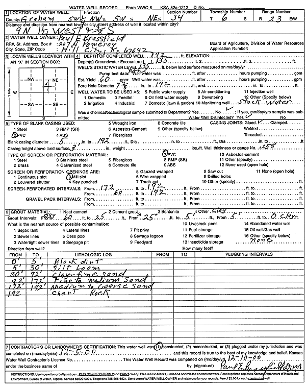
T6S, R23W, Sec. 34 SW NW SW NE |
Brassfield, Paul E | 192 ft. | 135 ft. | 60 gpm. | Domestic, Livestock | Constructed | 05-Dec-2000 | Scan | |
|
T6S, R23W, Sec. 34 SW NE SW |
Murfin Drilling/Paul Brassfield | 210 ft. | 130 ft. | Oil Field Water Supply | Constructed | 28-Jun-1994 | |||
|
T6S, R23W, Sec. 35 SE SW SW |
Baughman, Dave | 160 ft. | 89 ft. | 40 gpm. | Domestic | Constructed | 11-Sep-1997 | ||
|
T6S, R23W, Sec. 35 NE NE NE NW |
Paul Brassfield Estate | 205 ft. | 150 ft. | 30 gpm. | Domestic, Livestock | Constructed | 04-Dec-2014 |
KOLAR |
|
|
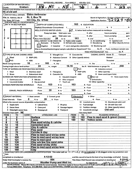
T6S, R23W, Sec. 36 NW NE NE |
Ambrosier, Eldon | 163 ft. | 60 ft. | Irrigation | Constructed | 12-Apr-2002 | Scan | ||
|
T6S, R23W, Sec. 36 NW NW NE |
Trefler, Gary | 152 ft. | 40 ft. | 600 gpm. | Irrigation | Constructed | 02-Jun-1976 | ||
|
T6S, R24W, Sec. 2 NW NE NE |
Beckman, Lonnie | 100 ft. | 20 ft. | 20 gpm. | Domestic, Livestock | Constructed | 30-Sep-2025 |
KOLAR |
|
|
T6S, R24W, Sec. 4 SE SE SE |
Jamison, Dean | 200 ft. | Domestic, changed from Oil Field Water Supply | Jamison 4-1 | Constructed | 15-Jan-2010 | |||
|
T6S, R24W, Sec. 4 SW SE SW |
Jamison, Gilbert | 66 ft. | Domestic | Constructed | 15-Jun-1989 | ||||
|
T6S, R24W, Sec. 5 SW SE SE |
David, John | 175 ft. | 98 ft. | Domestic | Constructed | 25-Aug-1997 | |||
|
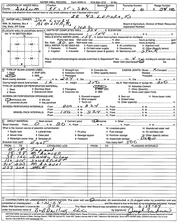
T6S, R24W, Sec. 7 SE SE SW |
Lowry, Don | 224 ft. | 154 ft. | 20 gpm. | Domestic, Livestock | Constructed | 10-Jun-2004 | Scan | |
|
T6S, R24W, Sec. 8 SE SE SE |
City of Lenora | 215 ft. | 123 ft. | Public Water Supply | Well 1 | Constructed | 10-Oct-1995 | ||
|
T6S, R24W, Sec. 9 SE NE NE |
Ninemire, John | 178 ft. | 147 ft. | 20 gpm. | Domestic | Constructed | 04-Nov-1996 | ||
|
T6S, R24W, Sec. 10 SE SE SE SE |
Beckman, Calvin | 210 ft. | 180 ft. | 45 gpm. | Oil Field Water Supply | Beckman Trust 10-1 | Constructed | 15-Oct-2012 |
KOLAR |
|
T6S, R24W, Sec. 10 NW SW SW |
Red Tiger Drilling/Mary Rush | 94 ft. | 29 ft. | Oil Field Water Supply | Constructed | 20-Jul-1988 | |||
|
T6S, R24W, Sec. 11 NE NE |
Kaw Pipeline | 10 ft. | Monitoring well/observation/piezometer | MW 3 | Constructed | 18-Oct-2000 | Scan | ||
|
T6S, R24W, Sec. 11 NE NE |
Kaw Pipeline | 9 ft. | Monitoring well/observation/piezometer | MW 4 | Constructed | 18-Oct-2000 | Scan | ||
|
T6S, R24W, Sec. 11 NE NE |
Kaw Pipeline | 15 ft. | Monitoring well/observation/piezometer | MW 2 | Constructed | 18-Oct-2000 | Scan | ||
| View page: 1 || 2 || 3 || 4 || 5 || 6 || 7 || 8 || 9 || 10 || Next > | |||||||||