Select location of well to view details.
Click on column heading to sort.
|
|
|
County: Grant Select location of well to view details. Click on column heading to sort. |
|
|
|
| View page: < Prev || 11 || 12 || 13 || 14 || 15 || 16 || 17 || 18 || 19 || 20 || Next > | |||||||||
| T-R-S | Owner | Well Depth Ascend. Desc. |
Static Water Level Ascend. Desc. |
Est. Yield Ascend. Desc. |
Well Use | Other ID | Action Taken | Completion Date Ascend. Desc. |
Scan? |
|
T28S, R37W, Sec. 21 SW SW NW |
Grant County Road Dept. | 54.5 ft. | 45 ft. | Test hole/well | SB 6 Exploratory Boring | Plugged | 29-Nov-1995 | ||
|
T28S, R37W, Sec. 21 SW SW NW |
Grant County Road Dept. | 59.62 ft. | 47.91 ft. | Monitoring well/observation/piezometer | MW 1 | Constructed | 21-Nov-1995 | ||
|
T28S, R37W, Sec. 21 SW SW NW |
Grant County Road Dept. | 45 ft. | 43.5 ft. | Test hole/well | SB 7 Exploratory Boring | Constructed | 01-Dec-1995 | ||
|
T28S, R37W, Sec. 21 SW SW NW |
Grant County Road Dept. | 59.6 ft. | 51.35 ft. | Monitoring well/observation/piezometer | MW 2 | Plugged | 08-Nov-2001 | ||
|
T28S, R37W, Sec. 21 SW SW NW |
Grant County Road Dept. | 58.9 ft. | 50.95 ft. | Monitoring well/observation/piezometer | MW 4 | Plugged | 08-Nov-2001 | ||
|
T28S, R37W, Sec. 21 SW SW NW |
Grant County Road Dept. | 59.1 ft. | 49.98 ft. | Monitoring well/observation/piezometer | MW 5 | Constructed | 06-Dec-1995 | ||
|
T28S, R37W, Sec. 21 SW SW NW |
Grant County Road Dept. | 65 ft. | 52.97 ft. | Monitoring well/observation/piezometer | MW 1R | Constructed | 10-Sep-2008 | ||
|
T28S, R37W, Sec. 21 SW SW NW |
Grant County Road Dept. | 58.2 ft. | 49.28 ft. | Monitoring well/observation/piezometer | MW 6 | Constructed | 07-Dec-1995 | ||
|
T28S, R37W, Sec. 21 SW SW NW |
Grant County Road Dept. | 59 ft. | 58.5 ft. | Test hole/well | SB 2 Exploratory boring | Constructed | 27-Nov-1995 | ||
|
T28S, R37W, Sec. 21 SW SW NW |
Grant County Road Dept. | 58.2 ft. | 49.98 ft. | Monitoring well/observation/piezometer | MW 2 | Constructed | 04-Dec-1995 | ||
|
T28S, R37W, Sec. 21 SW SW NW |
Grant County Road Dept. | 55 ft. | 50 ft. | Test hole/well | SB 3 Exploratory boring | Constructed | 28-Nov-1995 | ||
|
T28S, R37W, Sec. 21 SW SW NW |
Grant County Road Dept. | 55 ft. | Test hole/well | SB 4 Exploratory boring | Constructed | 29-Nov-1995 | |||
|
T28S, R37W, Sec. 21 SW SW NW |
Grant County Road Dept. | 55 ft. | Test hole/well | SB 5 Exploratory boring | Constructed | 29-Nov-1995 | |||
|
T28S, R37W, Sec. 21 SW SW NW |
Grant County Road Dept. | 64 ft. | Monitoring well/observation/piezometer | MW 6 | Plugged | 28-Mar-2007 | |||
|
T28S, R37W, Sec. 21 SW SW NW |
Grant County Road Dept. | 64 ft. | Monitoring well/observation/piezometer | MW 7 | Constructed | 28-Mar-2007 | |||
|
T28S, R37W, Sec. 21 SW SW NW |
Grant County Road Dept. | 63.7 ft. | 52.47 ft. | Monitoring well/observation/piezometer | MW 1 | Plugged | 10-Sep-2008 | ||
|
T28S, R37W, Sec. 21 SW SW NW |
Grant County Road Dept. | 59.2 ft. | 48.62 ft. | Monitoring well/observation/piezometer | MW 4 | Constructed | 05-Dec-1995 | ||
|
T28S, R37W, Sec. 21 SW SW NW |
Grant County Road Dept. | 59 ft. | 58.5 ft. | Test hole/well | SB 2 Exploratory boring | Plugged | 27-Nov-1995 | ||
|
T28S, R37W, Sec. 21 SW SW NW |
Grant County Road Dept. | 55 ft. | Test hole/well | SB 3 Exploratory boring | Plugged | 28-Nov-1995 | |||
|
T28S, R37W, Sec. 21 SW SW SW NW |
Grant County Roads Department | 64.49 ft. | 55.39 ft. | Monitoring well/observation/piezometer | MW 1 R | Plugged | 20-Sep-2011 | ||
|
T28S, R37W, Sec. 21 SW SW SW NW |
Grant County Roads Department | 62.89 ft. | 55.63 ft. | Monitoring well/observation/piezometer | MW 7 | Plugged | 20-Sep-2011 | ||
|
T28S, R37W, Sec. 21 SW SW SW NW |
Grant County Roads Department | 62.79 ft. | 56.95 ft. | Monitoring well/observation/piezometer | MW 6 R | Plugged | 20-Sep-2011 | ||
|
T28S, R37W, Sec. 21 SW SW SW NW |
Grant County Roads Department | 54.41 ft. | Monitoring well/observation/piezometer | MW 5 | Plugged | 20-Sep-2011 | |||
|
T28S, R37W, Sec. 21 SW SW SW NW |
Grant County Roads Department | 63.49 ft. | 52.79 ft. | Monitoring well/observation/piezometer | MW 3 | Plugged | 20-Sep-2011 | ||
|
T28S, R37W, Sec. 22 NW NW NE |
Helmly, Loyd | 358 ft. | 296 ft. | Domestic | Plugged | 17-Dec-1991 | |||
|
T28S, R37W, Sec. 23 C NE |
Dyck, Ed A, ETAL | 280 ft. | 175 ft. | 50 gpm. | Domestic | Constructed | 22-May-1986 | ||
|
T28S, R37W, Sec. 23 SW NE |
Gabbert and Jones Inc. | 200 ft. | 104 ft. | 40 gpm. | Oil Field Water Supply | Dyck A 3 | Constructed | 05-Mar-1976 | |
|
T28S, R37W, Sec. 24 NE NE NE |
Corser, Van | 513 ft. | 318 ft. | 40 gpm. | Domestic | Plugged | 20-Jul-2008 | ||
|
T28S, R37W, Sec. 24 NE NE NE |
Corser, Van | 525 ft. | 315 ft. | 40 gpm. | Domestic | Constructed | 22-Jul-2009 | ||
|
T28S, R37W, Sec. 24 NE NW SE |
Dyck, Edward | 42 ft. | 10 ft. | 20 gpm. | Domestic | Constructed | 27-Aug-1979 | ||
|
T28S, R37W, Sec. 24 S2 NE NE |
Gabbert and Jones Inc. | 360 ft. | 185 ft. | 80 gpm. | Oil Field Water Supply | Constructed | 11-Aug-1991 | ||
|
T28S, R37W, Sec. 24 SW SW SE |
Maldonado, Orlando | 495 ft. | 230 ft. | Domestic | Constructed | 29-Jun-2015 | |||
|
T28S, R37W, Sec. 24 SW |
Walker, Ron | 365 ft. | Domestic | Constructed | 27-Apr-1977 | ||||
|
T28S, R37W, Sec. 25 SE NW SE |
City of Ulysses | 90 ft. | 80 ft. | Monitoring well/observation/piezometer | Constructed | 03-Jul-1993 | |||
|
T28S, R37W, Sec. 25 NE NW SE |
City of Ulysses | 100 ft. | 85 ft. | Monitoring well/observation/piezometer | Constructed | 04-Jul-1993 | |||
|
T28S, R37W, Sec. 25 NW NW SE |
City of Ulysses | 75 ft. | 60 ft. | Monitoring well/observation/piezometer | Constructed | 05-Jul-1993 | |||
|
T28S, R37W, Sec. 25 NW NW NW |
Frazee, Ralph | 374 ft. | 182 ft. | 50 gpm. | Domestic, Livestock | Constructed | 25-Apr-2016 | ||
|
T28S, R37W, Sec. 25 C NW SE |
Grant County Landfill | 38 ft. | 17.9 ft. | Monitoring well/observation/piezometer | MW 8 | Constructed | 11-Jan-1997 | ||
|
T28S, R37W, Sec. 25 C NW SE |
Grant County Landfill | 39.5 ft. | 23.5 ft. | Monitoring well/observation/piezometer | MW 9 | Constructed | 11-Jan-1997 | ||
|
T28S, R37W, Sec. 25 SW NW SE |
Grant County Landfill | 38 ft. | 20 ft. | Monitoring well/observation/piezometer | MW 8 | Constructed | 07-Nov-1996 | ||
|
T28S, R37W, Sec. 25 SE NE SW |
Grant County Landfill | 40 ft. | 27 ft. | Monitoring well/observation/piezometer | MW 9 | Constructed | 07-Nov-1996 | ||
|
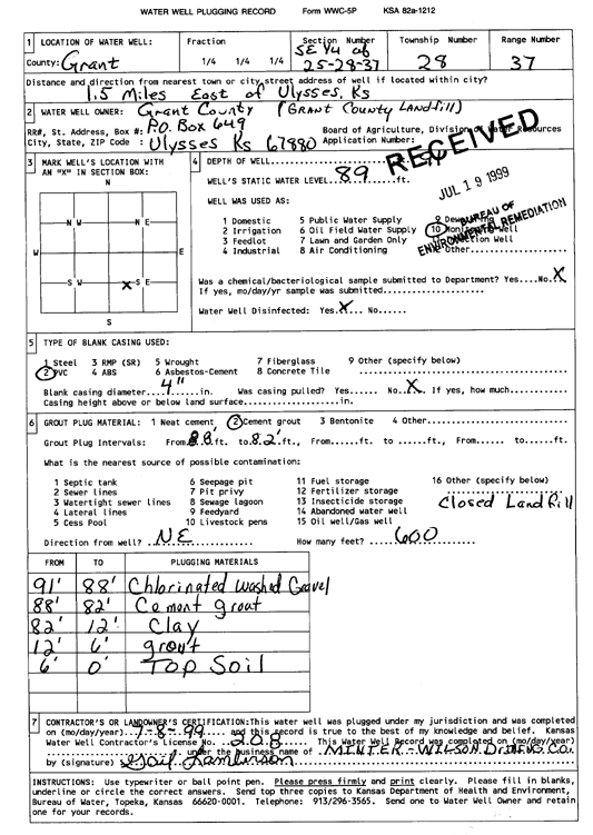
T28S, R37W, Sec. 25 SE |
Grant County Landfill | 91 ft. | 89 ft. | Monitoring well/observation/piezometer | Plugged | 08-Jul-1999 | Scan | ||
|
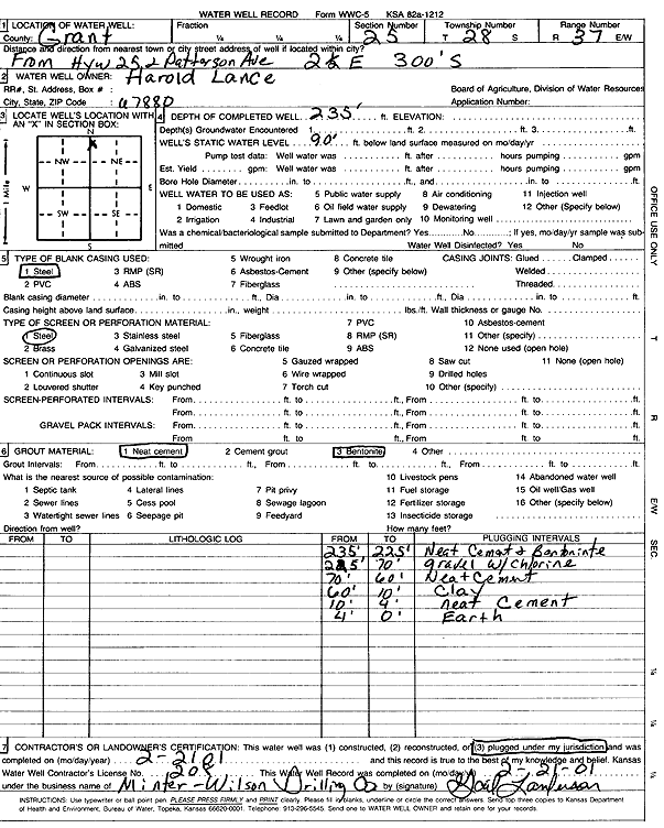
T28S, R37W, Sec. 25 NW NW NE |
Lance, Harold | 235 ft. | 90 ft. | Domestic | Plugged | 21-Feb-2001 | Scan | ||
|
T28S, R37W, Sec. 25 NW NW NE |
Lance, Irene | 356 ft. | 212 ft. | 32 gpm. | Domestic | Constructed | 04-Sep-1997 | ||
|
T28S, R37W, Sec. 26 NW NE NW SW |
Ramierez, Seferino | 505 ft. | 213 ft. | 25 gpm. | Domestic, Livestock | Constructed | 05-Nov-2021 |
KOLAR |
|
|
T28S, R37W, Sec. 26 SW SW SW |
Shipp, Dr. R. W. | 285 ft. | 60 ft. | 50 gpm. | Domestic | Constructed | 23-Mar-1987 | ||
|
T28S, R37W, Sec. 26 SE SE SE |
Stuart, Lamar | 50 ft. | 8 ft. | Domestic, Livestock | Constructed | 10-Aug-1987 | |||
|
T28S, R37W, Sec. 27 SE SE SW NW |
Bob Wilson Memorial Hospital | 80 ft. | 65.42 ft. | Monitoring well/observation/piezometer | MW7 | Constructed | 12-Jan-2017 |
KOLAR |
|
|
T28S, R37W, Sec. 27 SE SE SW NW |
Bob Wilson Memorial Hospital | 70 ft. | 68.61 ft. | Monitoring well/observation/piezometer | MW 3 | Constructed | 02-Dec-2015 | ||
|
T28S, R37W, Sec. 27 SE SE SW NW |
Bob Wilson Memorial Hospital | 75 ft. | 55.92 ft. | Monitoring well/observation/piezometer | MW 1 | Constructed | 18-Nov-2015 | ||
| View page: < Prev || 11 || 12 || 13 || 14 || 15 || 16 || 17 || 18 || 19 || 20 || Next > | |||||||||