Select location of well to view details.
Click on column heading to sort.
|
|
|
County: Grant Select location of well to view details. Click on column heading to sort. |
|
|
|
| View page: < Prev || 11 || 12 || 13 || 14 || 15 || 16 || 17 || 18 || 19 || 20 || Next > | |||||||||
| T-R-S | Owner | Well Depth Ascend. Desc. |
Static Water Level Ascend. Desc. |
Est. Yield Ascend. Desc. |
Well Use | Other ID | Action Taken | Completion Date Ascend. Desc. |
Scan? |
|
T28S, R37W, Sec. 27 NW NE NW |
Willinger, Bonnie | 99.9 ft. | Monitoring well/observation/piezometer | MCMW 3 | Plugged | 27-May-2015 | |||
|
T28S, R37W, Sec. 27 NW NE NW |
Willinger, Bonnie | 100 ft. | 71.5 ft. | Monitoring well/observation/piezometer | MW 3 | Constructed | 26-Jul-1995 | ||
|
T28S, R37W, Sec. 27 NW NW SW SE |
65 ft. | Other | SB 101 | Plugged | 08-May-2015 | ||||
|
T28S, R37W, Sec. 27 NW NW SW SE |
13 ft. | Other | SB 101 | Plugged | 20-May-2015 | ||||
|
T28S, R37W, Sec. 27 NW NW SW SE |
65 ft. | Other | SB 108 | Plugged | 18-May-2015 | ||||
|
T28S, R37W, Sec. 27 NW NW SW SE |
13 ft. | Other | SB 111 | Plugged | 20-May-2015 | ||||
|
T28S, R37W, Sec. 27 SE SW NW SE |
69 ft. | Monitoring well/observation/piezometer | MW 4 R | Constructed | 20-May-2015 | ||||
|
T28S, R37W, Sec. 27 SE SE SE SW |
75 ft. | Monitoring well/observation/piezometer | TW 14 | Constructed | 19-May-2015 | ||||
|
T28S, R37W, Sec. 27 SE SE NE SW |
80 ft. | Monitoring well/observation/piezometer | TW 12 | Constructed | 18-May-2015 | ||||
|
T28S, R37W, Sec. 27 NW NW SW SE |
75 ft. | 65 ft. | Monitoring well/observation/piezometer | SB 107/PTW 03 | Constructed | 17-May-2015 | |||
|
T28S, R37W, Sec. 27 NW NW SW SE |
75 ft. | 66 ft. | Monitoring well/observation/piezometer | SB 104/PTW 01 | Constructed | 07-May-2015 | |||
|
T28S, R37W, Sec. 27 NW NW SW SE |
73 ft. | 65 ft. | Monitoring well/observation/piezometer | SB 103 | Constructed | 16-May-2015 | |||
|
T28S, R37W, Sec. 27 NW NW SW SE |
65 ft. | Test hole/well | SB 109 | Plugged | 15-May-2015 | ||||
|
T28S, R37W, Sec. 27 NW NW SW SE |
76 ft. | Test hole/well | SB 105 | Plugged | 10-May-2015 | ||||
|
T28S, R37W, Sec. 27 NW NE SW SE |
70 ft. | Monitoring well/observation/piezometer | TW 15 | Constructed | 18-May-2015 | ||||
|
T28S, R37W, Sec. 27 NW NW SW SE |
75 ft. | Test hole/well | SB 110 | Plugged | 15-May-2015 | ||||
|
T28S, R37W, Sec. 27 NE NE SE SW |
82 ft. | Monitoring well/observation/piezometer | TW 13 | Constructed | 18-May-2015 | ||||
|
T28S, R37W, Sec. 27 NW NW SW SE |
67 ft. | Test hole/well | SB 106 | Plugged | 08-May-2015 | ||||
|
T28S, R37W, Sec. 27 NW NW SW SE |
70 ft. | Test Hole, Uncased | SB 102 | Constructed | 08-May-2015 | ||||
|
T28S, R37W, Sec. 28 SW NW SW NW |
Arnold, Mike | 375 ft. | 260 ft. | 30 gpm. | Domestic | Constructed | 24-Apr-2013 |
KOLAR |
|
|
T28S, R37W, Sec. 28 SE NW NW |
Fort, Earl | 390 ft. | Domestic | Constructed | 15-Oct-1975 | ||||
|
T28S, R37W, Sec. 28 SW SW SW |
Pioneer Electric Cooperative | 250 ft. | Injection well/air sparge (AS)/shallow | Constructed | 09-Sep-1996 | ||||
|
T28S, R37W, Sec. 28 NW SW NW |
Tucker, Bob | 340 ft. | 110 ft. | Domestic | Constructed | 23-Oct-1985 | |||
|
T28S, R37W, Sec. 28 SE SE NE SE |
USD 214 | 250 ft. | Heat Pump (Closed Loop/Disposal), Geothermal | Constructed | 11-Aug-2010 | ||||
|
T28S, R37W, Sec. 29 NE SE SW |
Delgado, Luis | 390 ft. | 160 ft. | Domestic | Constructed | 15-Oct-2024 |
KOLAR |
||
|
T28S, R37W, Sec. 29 SW SW SE |
Eldridge Well Service | 330 ft. | 163 ft. | 30 gpm. | Domestic | Constructed | 11-Apr-1979 | ||
|
T28S, R37W, Sec. 29 SW NW SW |
Green Acres Mobil Home Park | 283 ft. | 160 ft. | Domestic | Constructed | 26-Mar-1977 | |||
|
T28S, R37W, Sec. 29 C SW SE |
Ladner, Nadine | 345 ft. | 100 ft. | Domestic | Constructed | 02-Apr-1975 | |||
|
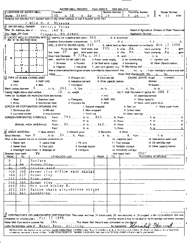
T28S, R37W, Sec. 29 SE SE SW |
Perry's Tires | 343 ft. | 235 ft. | 30 gpm. | (unstated)/abandoned | Constructed | 17-Oct-1998 | Scan | |
|
T28S, R37W, Sec. 29 NW SW SW |
Suncrest Properties | 292 ft. | 260 ft. | Domestic | Well 3 | Plugged | 14-Oct-2022 | ||
|
T28S, R37W, Sec. 29 NW SW SW |
Suncrest Properties | 300 ft. | 260 ft. | Domestic | Well 4 | Plugged | 14-Oct-2022 | ||
|
T28S, R37W, Sec. 29 NW SW SW |
Suncrest Properties | 300 ft. | 258 ft. | Domestic | Well 5 | Plugged | 14-Oct-2022 | ||
|
T28S, R37W, Sec. 29 NW SW NW SW |
USD 214 | 250 ft. | Heat Pump (Closed Loop/Disposal), Geothermal | Constructed | 10-Aug-2010 | ||||
|
T28S, R37W, Sec. 29 SW NW NW SW |
USD 214 | 250 ft. | Heat Pump (Closed Loop/Disposal), Geothermal | Constructed | 09-Aug-2010 | ||||
|
T28S, R37W, Sec. 29 SW SW SW |
Webber Supply/ WOW Partnership | 300 ft. | 150 ft. | 40 gpm. | Domestic | Constructed | 01-Jun-1990 | ||
|
T28S, R37W, Sec. 29 NW NE SW |
Webber, Steve | 380 ft. | 50 gpm. | Domestic | Constructed | 16-Mar-1990 | |||
|
T28S, R37W, Sec. 29 SE SW SE |
Young, O. D. | 284 ft. | 195 ft. | 20 gpm. | Domestic | Constructed | 07-Aug-1976 | ||
|
T28S, R37W, Sec. 30 NE NW NW |
Hickok, Bill | 375 ft. | 230 ft. | 40 gpm. | Domestic | Constructed | 26-Sep-1983 | ||
|
T28S, R37W, Sec. 31 SW NE SW |
Dieker, Steve | 396 ft. | 305 ft. | 50 gpm. | Domestic | Constructed | 01-Sep-1994 | ||
|
T28S, R37W, Sec. 31 NW SE SE NE |
Kugler Company | 541 ft. | 280 ft. | 70 gpm. | Industrial | Constructed | 13-Sep-2012 |
KOLAR |
|
|
T28S, R37W, Sec. 31 SW NE NE NE |
Pioneer Electric Cooperative | 228 ft. | 188 ft. | Industrial | Well 1 | Plugged | 20-Apr-2020 |
KOLAR |
|
|
T28S, R37W, Sec. 31 SW NE NE NE |
Pioneer Electric Cooperative | 290 ft. | 250 ft. | Industrial | Well 2 | Plugged | 20-Apr-2020 |
KOLAR |
|
|
T28S, R37W, Sec. 31 NW NE SE |
Rogers, Bill | 302 ft. | 207 ft. | 30 gpm. | Domestic | Constructed | 25-Feb-1991 | ||
|
T28S, R37W, Sec. 32 NE NW SE |
Banuelos, Octavio | 350 ft. | 20 gpm. | Domestic | Constructed | 24-Aug-2010 | |||
|
T28S, R37W, Sec. 32 SW SE NW |
City of Ulysses | 350 ft. | 182.5 ft. | Public Water Supply | Well 11 | Constructed | 22-Jun-1984 | ||
|
T28S, R37W, Sec. 32 SE NE NE |
Gregg Mobile Homes | 360 ft. | 200 ft. | 20 gpm. | Domestic | Constructed | 06-Oct-1978 | ||
|
T28S, R37W, Sec. 32 NW NE NE |
Rogers, Bill | 350 ft. | 210 ft. | 30 gpm. | Domestic | Constructed | 13-Apr-1982 | ||
|
T28S, R37W, Sec. 32 SW NW NW |
Vanderpool, Earl | 340 ft. | 200 ft. | Domestic | Constructed | 19-Nov-1976 | |||
|
T28S, R37W, Sec. 33 NW NW SW |
Banuelos, Octavio | 348 ft. | 100 ft. | Domestic | Constructed | 18-Oct-1989 | |||
|
T28S, R37W, Sec. 33 SE SE SE |
Meile Pamela and Marvin | 475 ft. | 45 ft. | Irrigation | Constructed | 02-Sep-1998 | |||
| View page: < Prev || 11 || 12 || 13 || 14 || 15 || 16 || 17 || 18 || 19 || 20 || Next > | |||||||||