Select location of well to view details.
Click on column heading to sort.
|
|
|
County: Barber Select location of well to view details. Click on column heading to sort. |
|
|
|
| View page: < Prev || 21 || 22 || 23 || 24 || 25 || 26 || 27 || 28 || 29 || 30 || Next > | |||||||||
| T-R-S | Owner | Well Depth Ascend. Desc. |
Static Water Level Ascend. Desc. |
Est. Yield Ascend. Desc. |
Well Use | Other ID | Action Taken | Completion Date Ascend. Desc. |
Scan? |
|
T32S, R12W, Sec. 2 NW SW NW |
McNamar, Darrel | 32 ft. | 6 ft. | 10 gpm. | Domestic | Constructed | 11-May-1989 | ||
|
T32S, R12W, Sec. 2 SW SW SW |
Taylor, Oscar | 32 ft. | 10 ft. | 50 gpm. | Domestic, Livestock | Constructed | 09-Aug-1979 | ||
|
T32S, R12W, Sec. 2 SW SW SW |
Wheelock, Brendon | 45 ft. | 5 ft. | 50 gpm. | Domestic, Livestock | Constructed | 01-Aug-2024 |
KOLAR |
|
|
T32S, R12W, Sec. 3 NW SE SE |
Clouse, Norm | 67 ft. | 21 ft. | 20 gpm. | Domestic, Lawn and Garden | Constructed | 14-Feb-2024 | ||
|
T32S, R12W, Sec. 3 SE NE SE |
Freshwater LLC | 42 ft. | 19 ft. | 9 gpm. | Industrial | Constructed | 17-May-2012 | ||
|
T32S, R12W, Sec. 3 SE NE SE |
Freshwater LLC | 42 ft. | 19 ft. | 20 gpm. | Industrial | Constructed | 17-May-2012 | ||
|
T32S, R12W, Sec. 3 SW SW SW |
Houlton, Richard/Graves Drilling Co. | 62 ft. | 15 ft. | 50 gpm. | Oil Field Water Supply | Houlton | Constructed | 23-Oct-1996 | |
|
T32S, R12W, Sec. 3 NW SE SE |
Krehbiel, Theron | 67 ft. | 19 ft. | 20 gpm. | Domestic | Constructed | 08-Aug-1983 | ||
|
T32S, R12W, Sec. 3 SE SE SE |
Krehbiel, Theron/Graves Drilling Co. | 50 ft. | 5 ft. | Oil Field Water Supply | Phyllis 1 | Plugged | 06-Mar-1986 | ||
|
T32S, R12W, Sec. 3 NW SW SW |
Lario Oil and Gas | 40 ft. | 12 ft. | Oil Field Water Supply | Constructed | 08-Jul-2014 | |||
|
T32S, R12W, Sec. 3 SE SE SE |
Phyllis, Jim/Graves Drilling Co. | 60 ft. | 4 ft. | 60 gpm. | Oil Field Water Supply | Phyllis 1 | Constructed | 14-Dec-1985 | |
|
T32S, R12W, Sec. 4 C NW SW |
D. R. Lauck Oil Co. | 23 ft. | 6 ft. | Oil Field Water Supply | Rynerson 1 | Constructed | 08-Feb-1982 | ||
|
T32S, R12W, Sec. 4 SW SW NE |
Graves Drilling Co., Inc. | 50 ft. | 21 ft. | 60 gpm. | Oil Field Water Supply | Constructed | 14-Feb-1980 | ||
|
T32S, R12W, Sec. 4 SW NW SW |
H-30 Drilling, Inc. | 30 ft. | 4 ft. | 40 gpm. | Oil Field Water Supply | Rynerson 2 | Constructed | 11-Dec-1985 | |
|
T32S, R12W, Sec. 4 SW SW SE |
Lorena Houlton Estate | 42 ft. | 11 ft. | 10 gpm. | Domestic | Constructed | 07-Oct-1986 | ||
|
T32S, R12W, Sec. 4 SW NE SE |
Rynerson, Max | 22 ft. | 7 ft. | 10 gpm. | Domestic | Constructed | 05-Oct-1994 | ||
|
T32S, R12W, Sec. 4 NE NE NW |
Simpson, Roger | 42 ft. | 27 ft. | 3 gpm. | Domestic | Constructed | 03-Nov-2003 | ||
|
T32S, R12W, Sec. 4 NE NW NW |
Van Rankin, Earl | 67 ft. | 40 ft. | 15 gpm. | Domestic | Constructed | 21-Feb-1992 | ||
|
T32S, R12W, Sec. 4 NW SE NE |
Wheelock, Brendon | 35 ft. | 18 ft. | 4 gpm. | Domestic, Livestock | Constructed | 07-Aug-2024 |
KOLAR |
|
|
T32S, R12W, Sec. 5 NE NW SE |
Charles W. and Velma Mae Thom Trusts | 62.5 ft. | 7.5 ft. | Irrigation | Constructed | 17-May-2011 | |||
|
T32S, R12W, Sec. 5 NE NW SE |
Charles W. and Velma Mae Thom Trusts | 57.6 ft. | 9 ft. | Irrigation | Plugged | 26-May-2011 | |||
|
T32S, R12W, Sec. 5 NE NW SE |
Clarke, Charles | 60 ft. | 11 ft. | 800 gpm. | Irrigation | Constructed | 18-Jul-1979 | ||
|
T32S, R12W, Sec. 5 SE NE SW |
Slawson Drilling Co. | 60 ft. | 12 ft. | Oil Field Water Supply | Constructed | 18-May-1979 | |||
|
T32S, R12W, Sec. 5 N2 SE SE |
Slawson Drilling Co. | 60 ft. | 6 ft. | 150 gpm. | Oil Field Water Supply | Constructed | 08-Jan-1979 | ||
|
T32S, R12W, Sec. 5 SE SE SE |
Thom, Charles (was Dixon Energy) | 60 ft. | 8 ft. | Domestic, changed from Oil Field Water Supply | Constructed | 22-Oct-2013 | |||
|
T32S, R12W, Sec. 5 NW SE SE |
Thom, Wayne | 35 ft. | 8 ft. | Irrigation | Plugged | 24-Feb-2012 | |||
|
T32S, R12W, Sec. 6 NW SW NE |
Bedwell, Tom | 32 ft. | 10 ft. | 10 gpm. | Domestic | Constructed | 05-May-1993 | ||
|
T32S, R12W, Sec. 6 NW SW NE |
Bedwell, Tom | 32 ft. | 10 ft. | Domestic | Plugged | 05-May-1993 | |||
|
T32S, R12W, Sec. 7 NW NE NW |
Vanderwork, G.C. | 32 ft. | 18 ft. | 5 gpm. | Domestic, Livestock | Constructed | 18-Dec-1978 | ||
|
T32S, R12W, Sec. 8 SE SE SE |
Bowe, Steve | 86 ft. | 63 ft. | 2 gpm. | Domestic | Constructed | 20-May-1993 | ||
|
T32S, R12W, Sec. 8 NW NW NW |
Langford, Tom | 65 ft. | 28 ft. | Domestic, Livestock | Constructed | 02-Oct-2012 | |||
|
T32S, R12W, Sec. 8 SE NW SE |
Texas Oil and Gas | 35 ft. | 18 ft. | 8 gpm. | Injection well/air sparge (AS)/shallow | Constructed | 31-Dec-1981 | ||
|
T32S, R12W, Sec. 9 SW NW NE |
Griffin Management | 52 ft. | 6 ft. | 60 gpm. | Oil Field Water Supply | Houlton | Constructed | 16-Nov-2012 | |
|
T32S, R12W, Sec. 9 NW SW NW |
Hoagland, Jeff | 32 ft. | 11 ft. | 20 gpm. | Domestic, Livestock | Constructed | 15-Dec-2012 | ||
|
T32S, R12W, Sec. 9 NE NE NW |
Orr, Trey | 48 ft. | 38 ft. | 10 gpm. | Domestic | Constructed | 29-Nov-1984 | ||
|
T32S, R12W, Sec. 9 SE SE NW |
Pickrell Drilling Co. | 30 ft. | 13 ft. | Oil Field Water Supply | Constructed | 06-Mar-1990 | |||
|
T32S, R12W, Sec. 10 SE SE NE |
Cunningham, Jack/Graves Drilling Co. | 35 ft. | 10 ft. | 60 gpm. | Oil Field Water Supply | Constructed | 24-Nov-1982 | ||
|
T32S, R12W, Sec. 10 NW SW SE |
Cunningham, Melvin | 32 ft. | 10 ft. | 10 gpm. | Domestic | Constructed | 22-Jul-1998 | ||
|
T32S, R12W, Sec. 10 SE SE NE |
Cunningham, Melvin/Graves Drilling Co. | 50 ft. | 5 ft. | Oil Field Water Supply | Cunningham 2 | Plugged | 06-Mar-1986 | ||
|
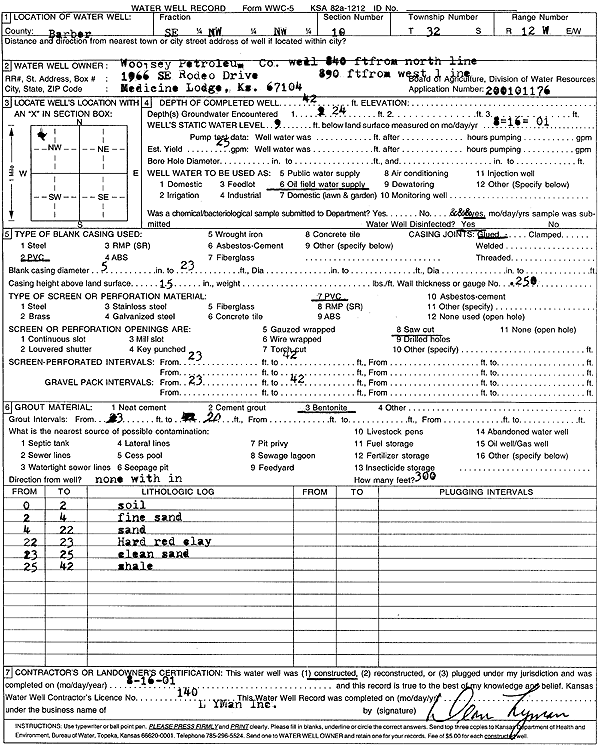
T32S, R12W, Sec. 10 SE NW NW |
Woolsey Petroleum Corp. | 42 ft. | 9 ft. | 25 gpm. | Oil Field Water Supply | Constructed | 16-Aug-2001 | Scan | |
|
T32S, R12W, Sec. 11 SE SW |
Carter, Harold C. | 48 ft. | 15 ft. | Domestic | Constructed | 23-Oct-1975 | |||
|
T32S, R12W, Sec. 11 SE NE NE |
Crescent Oil Co. | 23 ft. | Monitoring well/observation/piezometer | MW 8 | Constructed | 23-Apr-2008 | |||
|
T32S, R12W, Sec. 11 SE NE NE |
Crescent Oil Co. | 22 ft. | 17.1 ft. | Monitoring well/observation/piezometer | MW 5 | Plugged | 08-Apr-2024 |
KOLAR |
|
|
T32S, R12W, Sec. 11 SE NE NE |
Crescent Oil Co. | 19.8 ft. | 16.9 ft. | Monitoring well/observation/piezometer | MW 3 | Plugged | 08-Apr-2024 |
KOLAR |
|
|
T32S, R12W, Sec. 11 SE NE NE |
Crescent Oil Co. | 20 ft. | 17 ft. | Monitoring well/observation/piezometer | MW 1 | Plugged | 08-Apr-2024 |
KOLAR |
|
|
T32S, R12W, Sec. 11 NE SE NE |
Crescent Oil Co. | 23 ft. | 15.89 ft. | Monitoring well/observation/piezometer | MW 8 | Plugged | 08-Apr-2024 |
KOLAR |
|
|
T32S, R12W, Sec. 11 NE SE NE |
Crescent Oil Co. | 23 ft. | 15.09 ft. | Monitoring well/observation/piezometer | MW 9 | Plugged | 08-Apr-2024 |
KOLAR |
|
|
T32S, R12W, Sec. 11 NE SE NE |
Crescent Oil Co. | 22 ft. | 16 ft. | Monitoring well/observation/piezometer | MW 6 | Plugged | 08-Apr-2024 |
KOLAR |
|
|
T32S, R12W, Sec. 11 SE NE NE |
Crescent Oil Co. | 23 ft. | Monitoring well/observation/piezometer | MW 9 | Constructed | 24-Apr-2008 | |||
|
T32S, R12W, Sec. 11 SE NE NE |
Crescent Oil Co. | 22 ft. | 16.8 ft. | Monitoring well/observation/piezometer | MW 7 | Plugged | 08-Apr-2024 |
KOLAR |
|
| View page: < Prev || 21 || 22 || 23 || 24 || 25 || 26 || 27 || 28 || 29 || 30 || Next > | |||||||||