Select location of well to view details.
Click on column heading to sort.
|
|
|
County: Hamilton Select location of well to view details. Click on column heading to sort. |
|
|
|
| View page: < Prev || 11 || 12 || 13 || 14 || 15 || 16 || 17 || 18 | |||||||||
| T-R-S | Owner | Well Depth Ascend. Desc. |
Static Water Level Ascend. Desc. |
Est. Yield Ascend. Desc. |
Well Use | Other ID | Action Taken | Completion Date Ascend. Desc. |
Scan? |
|
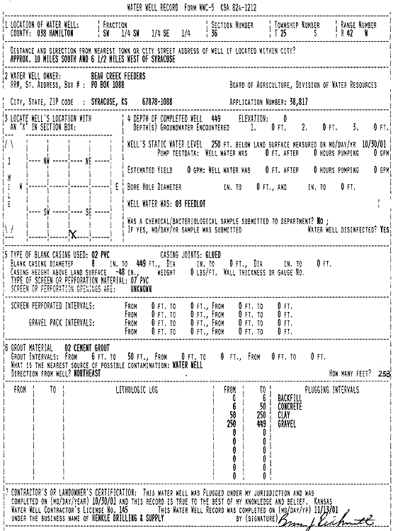
T25S, R42W, Sec. 36 SW SW SE |
Bear Creek Feeders | 449 ft. | 250 ft. | Feedlot | Plugged | 30-Oct-2001 | Scan | ||
|
T25S, R42W, Sec. 36 SE SE SW |
Bear Creek Feeders | 45 ft. | Monitoring well/observation/piezometer | MW 1 R 2 | Constructed | 01-Dec-2010 | |||
|
T25S, R42W, Sec. 36 SE SE SW |
Bear Creek Feeders | 40.5 ft. | 36.85 ft. | Monitoring well/observation/piezometer | SB 7/MW 4 | Constructed | 12-Jun-1995 | ||
|
T25S, R42W, Sec. 36 SE SE SW |
Bear Creek Feeders | 45 ft. | Monitoring well/observation/piezometer | MW 1 R | Plugged | 01-Dec-2010 | |||
|
T25S, R42W, Sec. 36 SW SW SE |
Cowtown Feeders, Inc. | 538 ft. | Feedlot | Constructed | 04-Oct-2001 | Scan | |||
|
T25S, R42W, Sec. 36 SW SW SE |
Frontier Dairy LLC | 557 ft. | 246 ft. | Feedlot | Constructed | 02-May-2011 | |||
|
T25S, R42W, Sec. 36 SW SW SE |
KDHE | 43.7 ft. | 26.98 ft. | Monitoring well/observation/piezometer | MW 7 | Constructed | 22-Apr-2014 | ||
|
T25S, R42W, Sec. 36 SE SE SW |
KDHE | 43.9 ft. | 26.28 ft. | Monitoring well/observation/piezometer | MW 7 | Plugged | 21-Oct-2014 | ||
|
T25S, R43W, Sec. 14 SW NE SE |
Southwest Plains Dairy LLC | 791 ft. | 515 ft. | Irrigation | Constructed | 14-Aug-2024 |
KOLAR |
||
|
T25S, R43W, Sec. 16 NW SE SE |
Prairie Dairy, LLC | 477 ft. | 290 ft. | Feedlot | Constructed | 13-May-2005 | |||
|
T25S, R43W, Sec. 16 NW NE SE |
Winger, Melvin | 370 ft. | 190 ft. | 3500 gpm. | Irrigation | Constructed | 04-May-1976 | ||
|
T25S, R43W, Sec. 21 NE SE NE |
Bear Creek Farms | 459 ft. | 293 ft. | Irrigation | Constructed | 27-Sep-2003 | Scan | ||
|
T25S, R43W, Sec. 21 NE SE NE |
Bear Creek Farms | 443 ft. | 280 ft. | 600 gpm. | Irrigation | Constructed | 07-Aug-1996 | ||
|
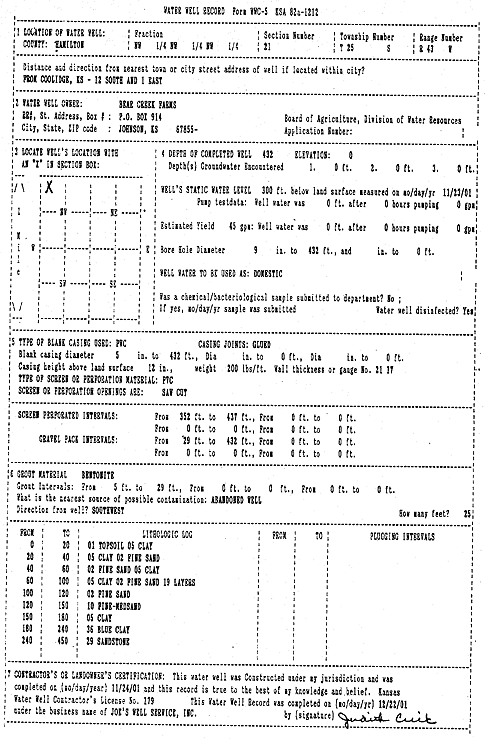
T25S, R43W, Sec. 21 NW NW NW |
Bear Creek Farms | 432 ft. | 300 ft. | 45 gpm. | Domestic | Constructed | 24-Nov-2001 | Scan | |
|
T25S, R43W, Sec. 21 C NW NE |
Bear Creek Farms | 403 ft. | 251 ft. | Irrigation | Plugged | 01-Feb-1996 | |||
|
T25S, R43W, Sec. 21 C NW NE |
Bear Creek Farms | 403 ft. | 251 ft. | 180 gpm. | Irrigation | Constructed | 06-Jul-1995 | ||
|
T25S, R43W, Sec. 21 SW NE NE |
Garrett-Jones Farms | 420 ft. | 160 ft. | 1200 gpm. | Irrigation | Constructed | 17-Apr-1975 | ||
|
T25S, R43W, Sec. 21 NW NW NE |
Syracuse Dairy LLC | 580 ft. | 222 ft. | Domestic | Constructed | 02-May-2025 |
KOLAR |
||
|
T25S, R43W, Sec. 23 NW NW NW |
Hatcher, Gary | 278 ft. | 240 ft. | 30 gpm. | Domestic | Constructed | 15-Feb-1977 | ||
|
T25S, R43W, Sec. 25 SE SE SW |
AK Coral Cay Family Trust | 780 ft. | 324 ft. | 550 gpm. | Irrigation | Constructed | 15-Aug-2024 |
KOLAR |
|
|
T25S, R43W, Sec. 25 SE SW SW |
Vyn, Justin | 515 ft. | 295 ft. | Irrigation | Constructed | 12-Dec-2006 | |||
|
T25S, R43W, Sec. 26 NE NW NE |
Gangwish, Leland | 420 ft. | 182.2 ft. | 800 gpm. | Irrigation | Constructed | 30-Jul-2004 | ||
|
T25S, R43W, Sec. 26 NW NE NE |
Garrett, Eldon | 420 ft. | 203 ft. | 1450 gpm. | Irrigation | Constructed | 01-Aug-1978 | ||
|
T25S, R43W, Sec. 26 SW NW NE |
Garrett-Jones Farms | 438 ft. | 156 ft. | 1500 gpm. | Irrigation | Constructed | 25-Apr-1975 | ||
|
T25S, R43W, Sec. 26 SE SE NE |
Garrett-Jones Farms | 435 ft. | 180 ft. | 1500 gpm. | Irrigation | Constructed | 05-May-1975 | ||
|
T25S, R43W, Sec. 27 NE NE NW |
Bear Creek Farms | 432 ft. | 223 ft. | 1500 gpm. | Irrigation | Constructed | 30-May-1979 | ||
|
T25S, R43W, Sec. 28 SE |
Barth Farms | 398 ft. | 302 ft. | Irrigation | Constructed | 16-Sep-2003 | Scan | ||
|
T25S, R43W, Sec. 35 SW SE SE NE |
Kansas Dairies | 740 ft. | 336 ft. | 1003 gpm. | Irrigation | Constructed | 03-Jul-2014 |
KOLAR |
|
|
T25S, R43W, Sec. 36 NE SW NE |
Chisolm, Emerson | 499.1 ft. | 140 ft. | 1050 gpm. | Irrigation | Constructed | 23-Feb-1977 | ||
|
T25S, R43W, Sec. 36 NW NE SW |
Chisolm, Emerson | 421.5 ft. | 201 ft. | 1800 gpm. | Irrigation | Constructed | 15-Apr-1977 | ||
|
T25S, R43W, Sec. 36 SW SW SW |
Frontier Dairy, LLC | 467 ft. | 308 ft. | Irrigation | Constructed | 04-Oct-2005 | |||
|
T25S, R43W, Sec. 36 SE SE SW |
Frontier Dairy, LLC | 461 ft. | 294 ft. | Irrigation | Constructed | 22-Feb-2005 | |||
|
T25S, R43W, Sec. 36 C NE |
Kansas Dairies (Frontier) | 483 ft. | 263 ft. | Irrigation | Constructed | 13-Dec-2005 | |||
|
T26S, R39W, Sec. 2 SW |
Fairbanks, David | 156 ft. | 15 ft. | Domestic | Plugged | 29-Oct-2009 | |||
|
T26S, R39W, Sec. 2 NE SW SW |
Fairbanks, David | 523 ft. | 206 ft. | 35 gpm. | Domestic | Constructed | 05-Aug-2009 | ||
|
T26S, R39W, Sec. 2 NW NW NW |
Rishel, Carl | 320 ft. | 140 ft. | 40 gpm. | Domestic | Constructed | 14-Feb-1980 | ||
|
T26S, R39W, Sec. 3 SE SE NE |
C Double Farms, LLC | 280 ft. | 182 ft. | 20 gpm. | Domestic, Livestock | Constructed | 06-Mar-2025 |
KOLAR |
|
|
T26S, R39W, Sec. 5 NW NW NW |
Akers, Barney | 492 ft. | 267 ft. | 50 gpm. | Domestic | Constructed | 31-Jul-1975 | ||
|
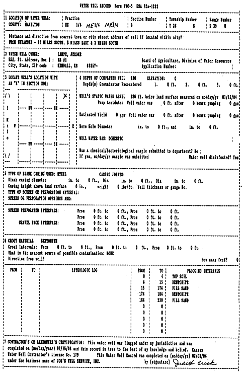
T26S, R39W, Sec. 9 NE |
Lampe, Jerome | 412 ft. | 300 ft. | Domestic | Plugged | 16-Jan-2009 | |||
|
T26S, R39W, Sec. 9 NE |
Lampe, Jerome | 442 ft. | 290 ft. | Domestic | Plugged | 16-Jan-2009 | |||
|
T26S, R39W, Sec. 9 NE NE NE |
Lampe, Jerome | 500 ft. | 240 ft. | 18 gpm. | Domestic | Constructed | 19-Jun-1995 | ||
|
T26S, R39W, Sec. 9 NE NE |
Lampe, Jerome | 593 ft. | Domestic | Constructed | 07-Jan-2009 | ||||
|
T26S, R39W, Sec. 9 NE NE NE |
Lampe, Jerome | 230 ft. | 186 ft. | Domestic | Plugged | 15-Jan-2004 | Scan | ||
|
T26S, R39W, Sec. 15 SW SW SW |
Shorter, David | 520 ft. | 230 ft. | 15 gpm. | Domestic | Constructed | 13-Apr-2011 | ||
|
T26S, R39W, Sec. 15 SW SW SW |
Shorter, David | 400 ft. | 230 ft. | (unstated)/abandoned | Plugged | 06-Jun-2011 | |||
|
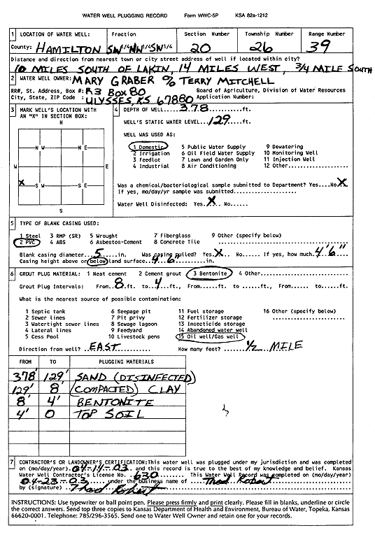
T26S, R39W, Sec. 20 SW NW SW |
Mary Graber | 378 ft. | 129 ft. | Domestic | Plugged | 14-Apr-2003 | Scan | ||
|
T26S, R39W, Sec. 26 NW SE NW |
Klassen, Herb | 255 ft. | 155 ft. | 50 gpm. | Domestic, Livestock | Constructed | 12-Mar-1979 | ||
|
T26S, R39W, Sec. 28 SE SE NW |
Tap Farms/Ann Palmer | 243 ft. | 182 ft. | Domestic | Plugged | 18-Sep-2003 | Scan | ||
|
T26S, R39W, Sec. 28 SE SE NW |
Tap Farms/Ann Palmer | 267 ft. | 114 ft. | Domestic | Constructed | 11-Sep-2003 | Scan | ||
|
T26S, R40W, Sec. 14 NW NW NW |
Joanice, Jantz | 240 ft. | 0 ft. | Domestic | Plugged | 17-May-2020 | |||
| View page: < Prev || 11 || 12 || 13 || 14 || 15 || 16 || 17 || 18 | |||||||||