Select location of well to view details.
Click on column heading to sort.
|
|
|
County: Hamilton Select location of well to view details. Click on column heading to sort. |
|
|
|
| View page: < Prev || 11 || 12 || 13 || 14 || 15 || 16 || 17 || 18 | |||||||||
| T-R-S | Owner | Well Depth Ascend. Desc. |
Static Water Level Ascend. Desc. |
Est. Yield Ascend. Desc. |
Well Use | Other ID | Action Taken | Completion Date Ascend. Desc. |
Scan? |
|
T26S, R40W, Sec. 16 NW NW NW |
Lampe, Bob | 510 ft. | 223 ft. | 15 gpm. | Domestic | Constructed | 10-Sep-1996 | ||
|
T26S, R40W, Sec. 17 SE SE NW |
Finlay, Ronald E. | 205 ft. | 85 ft. | Domestic | Constructed | 05-May-1994 | |||
|
T26S, R40W, Sec. 19 NE NE NE |
Lewis, John C. | 230 ft. | 110 ft. | 20 gpm. | Domestic | Constructed | 03-Jul-1979 | ||
|
T26S, R40W, Sec. 19 SE SE SE |
Syracuse Dairy | 555 ft. | 347 ft. | Feedlot | Constructed | 29-Aug-1997 | |||
|
T26S, R40W, Sec. 22 NW NW NW |
Brehm, Adolph | 518 ft. | 272 ft. | 30 gpm. | Domestic | Constructed | 01-May-1985 | ||
|
T26S, R40W, Sec. 23 SW SE SE |
Jantz, Joanice | 262 ft. | 0 ft. | Domestic | Plugged | 18-May-2020 | |||
|
T26S, R40W, Sec. 24 SW SE SW |
Lewis, John C. | 380 ft. | 110 ft. | 35 gpm. | Domestic | Constructed | 30-Jun-1979 | ||
|
T26S, R40W, Sec. 31 SE SW SE |
Syracuse Dairy | 477 ft. | 247 ft. | 82 gpm. | Irrigation | Constructed | 21-May-1998 | ||
|
T26S, R40W, Sec. 36 SW SE SE |
Combs, Melvin | 108 ft. | 46 ft. | 12 gpm. | Domestic | Constructed | 22-Jul-1977 | ||
|
T26S, R41W, Sec. 2 SE NE NE |
Hook, Kathlene | 505 ft. | 254 ft. | 30 gpm. | Domestic | Constructed | 18-Sep-2007 | ||
|
T26S, R41W, Sec. 2 SE NE SE |
Lennen, Charles | 284 ft. | 196 ft. | 25 gpm. | Domestic | Constructed | 15-Nov-1995 | Scan | |
|
T26S, R41W, Sec. 19 SW SW NE NW |
AK Coral Cay Trust | 687 ft. | 280 ft. | 365 gpm. | Irrigation | Constructed | 25-Oct-2012 |
KOLAR |
|
|
T26S, R41W, Sec. 19 C SW |
McCormick Farms | 640 ft. | 180 ft. | Irrigation | Plugged | 31-Oct-1983 | |||
|
T26S, R41W, Sec. 19 NE NE NE |
McCormick, Steve | 318 ft. | 80 ft. | 50 gpm. | Domestic | Constructed | 09-Apr-1985 | ||
|
T26S, R41W, Sec. 20 NW NW NW |
Braddock, Dan | 535 ft. | 101 ft. | 30 gpm. | Domestic | Constructed | 16-Aug-2004 | ||
|
T26S, R41W, Sec. 20 NW NW SW |
Collin, Charles | 478 ft. | 137 ft. | 1400 gpm. | Irrigation | Constructed | 28-Sep-1976 | ||
|
T26S, R41W, Sec. 20 SW SW NE |
Farmer's Home Adminsitration | 160 ft. | 55 ft. | Domestic | Constructed | 20-Nov-1980 | |||
|
T26S, R41W, Sec. 20 NW NW SE |
Nickerson, Clarence | 155 ft. | 35 ft. | 75 gpm. | Oil Field Water Supply | Constructed | 12-Jan-1990 | ||
|
T26S, R41W, Sec. 24 SW SE SW |
Lewis, John | 462 ft. | 260 ft. | Domestic | Constructed | 20-Mar-1993 | |||
|
T26S, R41W, Sec. 25 NE NE NW |
Lewis, John | 460 ft. | 292 ft. | Domestic | Constructed | 15-Aug-2001 | Scan | ||
|
T26S, R41W, Sec. 25 NE NE NW |
Lewis, John | 495 ft. | 265 ft. | Domestic | Constructed | 23-Oct-1989 | |||
|
T26S, R41W, Sec. 31 NW NW |
Goodhart, Eric | 635 ft. | 250 ft. | Irrigation | Constructed | 15-May-2009 | |||
|
T26S, R41W, Sec. 32 SW NE SE |
Goodhart, Eric | 669 ft. | 231 ft. | Irrigation | Constructed | 27-Sep-2007 | |||
|
T26S, R41W, Sec. 32 SW SW SW |
Vyn, Josh | 657 ft. | 212 ft. | Irrigation | Constructed | 04-Oct-2007 | |||
|
T26S, R41W, Sec. 34 SE NW SE |
Golden Spread Inc. | 618 ft. | 139 ft. | 400 gpm. | Irrigation | Constructed | 18-Jun-1992 | ||
|
T26S, R41W, Sec. 34 SW SE SW |
Lewis, Irvin, Jr. | 295.6 ft. | 72 ft. | 1500 gpm. | Irrigation | Constructed | 04-Sep-1975 | ||
|
T26S, R41W, Sec. 34 SW SW NW |
Northwestern Mutual Life | 573 ft. | 68 ft. | 1160 gpm. | Irrigation | Constructed | 02-May-1983 | ||
|
T26S, R41W, Sec. 34 SW SW NW |
Pauls, Duane | 575 ft. | Irrigation | Constructed | 10-Aug-1999 | Scan | |||
|
T26S, R41W, Sec. 36 SW SW SW |
Lewis, John | 551 ft. | 159 ft. | 900 gpm. | Irrigation | Constructed | 08-Jul-1992 | ||
|
T26S, R41W, Sec. 36 NW NW NW |
Syracuse Dairy LLC | 520 ft. | 324 ft. | 20 gpm. | Domestic | Constructed | 23-Oct-2024 |
KOLAR |
|
|
T26S, R41W, Sec. 36 SE SW SE |
Syracuse Dairy LLC | 540 ft. | 199 ft. | Irrigation | Constructed | 09-Jun-1999 | Scan | ||
|
T26S, R42W, Sec. 3 SE SW SW |
Beckett, Nancy R. | 467 ft. | 138 ft. | Irrigation | Reconstructed | 26-Oct-1989 | |||
|
T26S, R42W, Sec. 4 SE NW SE |
Burle, Larry | 280 ft. | 200 ft. | 15 gpm. | Domestic, Livestock | Constructed | 12-Mar-2025 |
KOLAR |
|
|
T26S, R42W, Sec. 5 |
Buhrle, Larry | 270 ft. | 126 ft. | 50 gpm. | Domestic | Constructed | 03-Nov-2020 | ||
|
T26S, R42W, Sec. 6 NW NW NE |
Beltz, Charles | 204 ft. | 120 ft. | 45 gpm. | Domestic | Constructed | 12-Sep-1997 | ||
|
T26S, R42W, Sec. 6 NW NE NW |
Hughes, W.T. | 365 ft. | 160 ft. | 50 gpm. | Domestic | Constructed | 23-Aug-1979 | ||
|
T26S, R42W, Sec. 7 NW NW NW |
Fox, Kevin | 310 ft. | 190 ft. | 30 gpm. | Domestic | Constructed | 01-Jul-1995 | ||
|
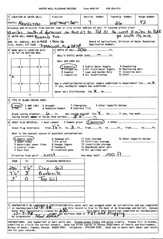
T26S, R42W, Sec. 7 NW NW SW |
Fox, Ronald | 206 ft. | Domestic | Plugged | 07-Dec-1998 | Scan | |||
|
T26S, R42W, Sec. 7 NW NW SW |
Lewis, Duane | 397.2 ft. | 229 ft. | 1000 gpm. | Irrigation | Constructed | 04-Dec-1979 | ||
|
T26S, R42W, Sec. 7 NE NE SW |
Southwest Plains Dairy | 712 ft. | 310 ft. | 650 gpm. | Irrigation | Constructed | 03-Feb-2026 |
KOLAR |
|
|
T26S, R42W, Sec. 8 SW SW SW |
D and L Farms | 468 ft. | 222 ft. | Irrigation | Constructed | 17-Apr-2010 | |||
|
T26S, R42W, Sec. 8 SW SW SW |
Potter, Dee | 460 ft. | 162 ft. | 1000 gpm. | Irrigation | Constructed | 30-Nov-1982 | ||
|
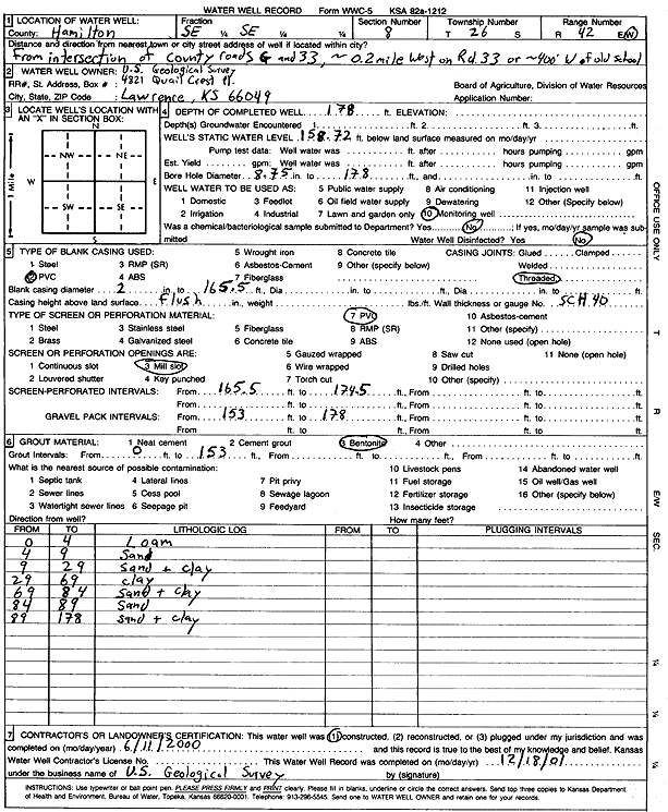
T26S, R42W, Sec. 8 SE SE |
U.S. Geological Survey | 178 ft. | 158.7 ft. | Monitoring well/observation/piezometer | Constructed | 11-Jun-2000 | Scan | ||
|
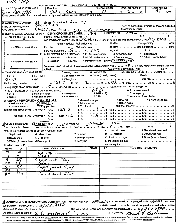
T26S, R42W, Sec. 8 SW SW |
U.S. Geological Survey | 178 ft. | 158.7 ft. | Monitoring well/observation/piezometer | Constructed | 11-Jun-2000 | Scan | ||
|
T26S, R42W, Sec. 10 SW SE NE |
EZ Farms | 763 ft. | 302 ft. | Irrigation | Constructed | 24-Feb-2026 |
KOLAR |
||
|
T26S, R42W, Sec. 10 SW NW NW |
Holdren, Charles | 438 ft. | 135 ft. | 1500 gpm. | Irrigation | Constructed | 06-Jun-1977 | ||
|
T26S, R42W, Sec. 10 SW NW NW |
Holdren, Charles W. | 470 ft. | 163 ft. | Irrigation | Constructed | 22-Oct-1992 | |||
|
T26S, R42W, Sec. 10 NW SW SE |
Milk Palace Dairy | 450 ft. | 142 ft. | Irrigation | Constructed | 07-Mar-2002 | Scan | ||
|
T26S, R42W, Sec. 10 SW NW SE |
Vyn, Justin | 419 ft. | 150 ft. | Irrigation | Constructed | 05-May-2006 | |||
|
T26S, R42W, Sec. 11 SW SE NW |
Holdren, Charles | 449 ft. | 140 ft. | 1000 gpm. | Irrigation | Constructed | 24-Jul-1990 | ||
| View page: < Prev || 11 || 12 || 13 || 14 || 15 || 16 || 17 || 18 | |||||||||