Select location of well to view details.
Click on column heading to sort.
|
|
|
County: Haskell Select location of well to view details. Click on column heading to sort. |
|
|
|
| View page: 1 || 2 || 3 || 4 || 5 || 6 || 7 || 8 || 9 || 10 || Next > | |||||||||
| T-R-S | Owner | Well Depth Ascend. Desc. |
Static Water Level Ascend. Desc. |
Est. Yield Ascend. Desc. |
Well Use | Other ID | Action Taken | Completion Date Ascend. Desc. |
Scan? |
|
T27S, R31W, Sec. 9 NE SW NW |
Koehn, John | 360 ft. | 207 ft. | Irrigation | Constructed | 20-Feb-2008 | |||
|
T27S, R31W, Sec. 9 C NE NE |
Medeo, Dorothy | 300 ft. | 120 ft. | 75 gpm. | Oil Field Water Supply | Constructed | 13-Oct-1982 | ||
|
T27S, R31W, Sec. 9 NE SW NE |
Meserly, Bob | 344 ft. | 79 ft. | 1475 gpm. | Irrigation | Constructed | 24-Jun-1976 | ||
|
T27S, R31W, Sec. 9 NW SE SW |
Nightingale, Jerrell | 430 ft. | 196 ft. | Irrigation | Constructed | 20-Nov-2003 | Scan | ||
|
T27S, R31W, Sec. 10 NE SW SE |
Kleysteuber, Dennis | 409 ft. | 194 ft. | Irrigation | Constructed | 15-Apr-2008 | |||
|
T27S, R31W, Sec. 10 SE NW SW |
Nightengale, Kenneth | 300 ft. | 176 ft. | Irrigation | Constructed | 20-May-2003 | Scan | ||
|
T27S, R31W, Sec. 10 NE SW SW |
Nightengale, Kenneth | 230 ft. | 185 ft. | Irrigation | Plugged | 01-Jan-2004 | Scan | ||
|
T27S, R31W, Sec. 10 NE NW SW SW |
R & L Farms | 478 ft. | 244 ft. | 1412 gpm. | Irrigation | Constructed | 13-Dec-2012 |
KOLAR |
|
|
T27S, R31W, Sec. 10 NW NW NW |
Slawson Drilling Co. | 180 ft. | 110 ft. | 70 gpm. | Oil Field Water Supply | Reconstructed | 29-Nov-1982 | ||
|
T27S, R31W, Sec. 10 SW SW SW |
Unruh, Richard | 365 ft. | 180 ft. | Domestic | Constructed | 18-May-2006 | |||
|
T27S, R31W, Sec. 10 SW SW NW |
Unruh, Richard and Lana | 290 ft. | 219.5 ft. | Irrigation | test 5 | Constructed | 17-Mar-2010 | ||
|
T27S, R31W, Sec. 11 NW NW SW |
Ardery, Ross | 345 ft. | 208 ft. | Irrigation | Constructed | 25-Jul-2007 | |||
|
T27S, R31W, Sec. 11 SW SW SE |
Ardery, Ross | 280 ft. | 150 ft. | Domestic | Constructed | 03-Nov-1995 | |||
|
T27S, R31W, Sec. 11 SW SW SE |
Ardery, Ross | 154 ft. | 150 ft. | Domestic | Plugged | 04-Nov-1995 | |||
|
T27S, R31W, Sec. 11 SW SW SW |
Audrey, Ross | 505 ft. | 244 ft. | Domestic | Constructed | 25-Apr-2025 |
KOLAR |
||
|
T27S, R31W, Sec. 11 SE SE SW |
Audrey, Ross | 485 ft. | 229 ft. | Domestic, Livestock | Constructed | 04-Apr-2025 |
KOLAR |
||
|
T27S, R31W, Sec. 12 SE |
Hoskinson, Elzira | 215 ft. | 89 ft. | 1850 gpm. | Irrigation | Constructed | 27-Jan-1978 | ||
|
T27S, R31W, Sec. 12 NW SW NW |
Nally, Eugene | 200 ft. | 195 ft. | Irrigation | Plugged | 04-Apr-2005 | |||
|
T27S, R31W, Sec. 12 NE |
Nally, Eugene | 200 ft. | 195 ft. | Irrigation | Plugged | 04-Apr-2005 | |||
|
T27S, R31W, Sec. 13 NW SW SE |
Koehn, Howard | 195 ft. | 160 ft. | Irrigation | Plugged | 06-Apr-2000 | Scan | ||
|
T27S, R31W, Sec. 13 SW NW SW |
Koehn, Howard | 486 ft. | 140 ft. | 1500 gpm. | Irrigation | Constructed | 07-Feb-1990 | ||
|
T27S, R31W, Sec. 13 SW NW SW |
Koehn, Howard | 260 ft. | 145 ft. | 600 gpm. | Irrigation | Constructed | 08-Apr-1996 | ||
|
T27S, R31W, Sec. 13 W2 W2 SW |
Koehn, Howard | 195 ft. | 130 ft. | Irrigation | Plugged | 07-Apr-1990 | |||
|
T27S, R31W, Sec. 13 NE NE SE |
Neudorf, Jakie | 500 ft. | 305 ft. | 45 gpm. | Domestic | Constructed | 18-Nov-2023 |
KOLAR |
|
|
T27S, R31W, Sec. 14 NW NE NW |
Frank, Floyd | 220 ft. | 90 ft. | Domestic | Constructed | 28-Jun-1978 | |||
|
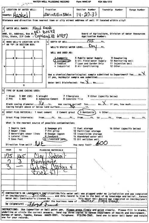
T27S, R31W, Sec. 14 SW NE NW |
Frank, Floyd | 175 ft. | Irrigation | Plugged | 01-Mar-2002 | Scan | |||
|
T27S, R31W, Sec. 14 SW NE NW |
Frank, Floyd | 260 ft. | 120 ft. | 1100 gpm. | Irrigation | Constructed | 28-Apr-1996 | ||
|
T27S, R31W, Sec. 14 NE NE NW |
Frank, Gale | 410 ft. | Domestic | Constructed | 01-Mar-2011 | ||||
|
T27S, R31W, Sec. 14 NW NE SW |
William and Lindberger | 177 ft. | 139 ft. | Irrigation | Plugged | 12-Apr-1990 | |||
|
T27S, R31W, Sec. 14 NW NE SW |
William and Lindberger | 361 ft. | 140 ft. | 2000 gpm. | Irrigation | Constructed | 26-Mar-1990 | ||
|
T27S, R31W, Sec. 15 NW NW NE |
Frank, Floyd | 329 ft. | 122 ft. | Irrigation | Constructed | 28-Dec-1980 | |||
|
T27S, R31W, Sec. 15 NW NW NW |
Frank, Gale | 420 ft. | 230 ft. | 10 gpm. | Domestic, Livestock | Constructed | 08-Sep-2009 | ||
|
T27S, R31W, Sec. 15 SW SW SW |
Frank, Gale | 770 ft. | 271 ft. | 1200 gpm. | Irrigation | Constructed | 04-Mar-2022 |
KOLAR |
|
|
T27S, R31W, Sec. 15 SW SW SW |
Frank, Gale | 328 ft. | 261 ft. | Irrigation | Plugged | 06-Mar-2024 |
KOLAR |
||
|
T27S, R31W, Sec. 15 NW NW NW |
Frank, Gale | 470 ft. | 238 ft. | Irrigation | 15 N | Constructed | 23-Feb-2012 | ||
|
T27S, R31W, Sec. 15 SW NW NW |
Frank, Gale | 299 ft. | 246 ft. | Irrigation | Plugged | 22-May-2012 | |||
|
T27S, R31W, Sec. 15 NW NE |
Frank, Gale | 805 ft. | 250 ft. | Irrigation | Constructed | 13-Jun-2015 | |||
|
T27S, R31W, Sec. 15 SW NW SW SW |
Frank, Gale | 630 ft. | 265 ft. | 100 gpm. | Domestic | Constructed | 28-Apr-2015 |
KOLAR |
|
|
T27S, R31W, Sec. 15 SW NW SW |
Koehn, Cleman | 300 ft. | 130 ft. | 50 gpm. | Domestic | Constructed | 15-Sep-1981 | ||
|
T27S, R31W, Sec. 15 SW |
Koehn, Clemen | 330 ft. | 118 ft. | 1900 gpm. | Irrigation | Constructed | 28-Feb-1978 | ||
|
T27S, R31W, Sec. 15 NW SW NE |
Koehn, Leslie | 332 ft. | 140 ft. | 1500 gpm. | Irrigation | Constructed | 17-Jun-1985 | ||
|
T27S, R31W, Sec. 15 SE SE SE |
Koehn, Leslie | 205 ft. | 100 ft. | 60 gpm. | Domestic | Constructed | 24-Aug-1978 | ||
|
T27S, R31W, Sec. 15 NW SW SE |
Koehn, Obed | 240 ft. | 115 ft. | 2000 gpm. | Irrigation | Constructed | 15-Jun-1977 | ||
|
T27S, R31W, Sec. 15 NE SE SW |
Koehn, Rick | 765 ft. | 275 ft. | 1000 gpm. | Irrigation | Constructed | 02-Nov-2023 |
KOLAR |
|
|
T27S, R31W, Sec. 15 C NE SE |
Koehn, Rick | 319 ft. | 209 ft. | 25 gpm. | Domestic | Constructed | 07-Sep-2005 | ||
|
T27S, R31W, Sec. 15 SW SW NE |
Slawson Drilling Co. | 165 ft. | 120 ft. | 70 gpm. | Oil Field Water Supply | Koehn 1 | Constructed | 13-Feb-1981 | |
|
T27S, R31W, Sec. 15 NE SW SW |
U.S. Geological Survey | 190 ft. | 164 ft. | Monitoring well/observation/piezometer | Constructed | 14-Nov-1998 | Scan | ||
|
T27S, R31W, Sec. 16 SW SW SW |
Frank, Floyd | 290 ft. | 110 ft. | Irrigation | Constructed | 15-Jun-1977 | |||
|
T27S, R31W, Sec. 16 SW NE NE |
Frank, Floyd | 320 ft. | 105 ft. | Irrigation | Constructed | ||||
|
T27S, R31W, Sec. 16 C S2 SW NW |
Frank, Gale | 295 ft. | 257 ft. | Irrigation | Plugged | 01-Nov-2012 | |||
| View page: 1 || 2 || 3 || 4 || 5 || 6 || 7 || 8 || 9 || 10 || Next > | |||||||||