Select location of well to view details.
Click on column heading to sort.
|
|
|
County: Haskell Select location of well to view details. Click on column heading to sort. |
|
|
|
| View page: < Prev || 21 || 22 || 23 || 24 || 25 || 26 || 27 || 28 || 29 || 30 || Next > | |||||||||
| T-R-S | Owner | Well Depth Ascend. Desc. |
Static Water Level Ascend. Desc. |
Est. Yield Ascend. Desc. |
Well Use | Other ID | Action Taken | Completion Date Ascend. Desc. |
Scan? |
|
T28S, R33W, Sec. 9 SE SE SE |
F and E Cox Farms, Inc. | 622 ft. | 390 ft. | Domestic | Constructed | 27-Apr-2001 | Scan | ||
|
T28S, R33W, Sec. 9 SE SW SE |
Farms, John T. | 440 ft. | 287 ft. | Domestic | Constructed | 16-Oct-1976 | |||
|
T28S, R33W, Sec. 9 SE SE SW |
Farms, John T./ Cox, Forrest | 770 ft. | 347 ft. | 1000 gpm. | Irrigation | Constructed | 13-Mar-1985 | ||
|
T28S, R33W, Sec. 9 NW NW NW SW |
Friona Cattle Feeders | 624 ft. | 431 ft. | Feedlot | Plugged | 30-Oct-2019 | |||
|
T28S, R33W, Sec. 10 NW SE SW |
Cox, Kenneth | 605 ft. | 288 ft. | 1500 gpm. | Irrigation | Constructed | 30-May-1978 | ||
|
T28S, R33W, Sec. 10 SE NW NE |
Oxy USA Inc Hugoton Asset | 480 ft. | 352 ft. | 65 gpm. | Industrial | Constructed | 21-Jan-2014 | ||
|
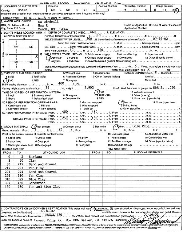
T28S, R33W, Sec. 10 NE NE SE |
SW Windmill | 460 ft. | 300 ft. | Domestic | Constructed | 16-Jul-2002 | Scan | ||
|
T28S, R33W, Sec. 11 N2 N2 SW |
Cox, Forrest | 458 ft. | 288 ft. | 1451 gpm. | Irrigation | Constructed | 01-Nov-1976 | ||
|
T28S, R33W, Sec. 11 NW SW SE |
Cox, Forrest | 443 ft. | 284 ft. | 1435 gpm. | Irrigation | Constructed | 26-Oct-1976 | ||
|
T28S, R33W, Sec. 11 NW |
Griffen, Wayne | 481 ft. | 303 ft. | 1250 gpm. | Irrigation | Constructed | 30-Jun-1978 | ||
|
T28S, R33W, Sec. 12 NE NE NE |
Cox, Forrest | 603 ft. | 250 ft. | 50 gpm. | Domestic | Constructed | 24-Jul-1979 | ||
|
T28S, R33W, Sec. 12 C E2 SW |
Cox, Forrest | 594 ft. | 305 ft. | Irrigation | Constructed | 17-Dec-1981 | |||
|
T28S, R33W, Sec. 12 NE SE SW |
Cox, Forrest | 580 ft. | 245 ft. | 1800 gpm. | Irrigation | Constructed | 04-Jun-1975 | ||
|
T28S, R33W, Sec. 12 SW SE NW |
Hill, Dennis | 515 ft. | 380 ft. | Oil Field Water Supply | Constructed | 25-Aug-2005 | |||
|
T28S, R33W, Sec. 12 SW SE NW |
Hill, Dennis | 515 ft. | 380 ft. | Oil Field Water Supply | Plugged | 15-Sep-2009 | |||
|
T28S, R33W, Sec. 13 NW SW NW |
Kenneth Cox Trust | 668 ft. | 385 ft. | Irrigation | Constructed | 21-Jul-2008 | |||
|
T28S, R33W, Sec. 13 NW NW SE |
Kenny Cox | 743 ft. | 350 ft. | Irrigation | Constructed | 08-May-1999 | Scan | ||
|
T28S, R33W, Sec. 14 SE NW SE |
Barbee Family Trust: Granger Family Trust | 515 ft. | Oil Field Water Supply | Constructed | 22-Dec-2004 | ||||
|
T28S, R33W, Sec. 14 SE SE NW |
Cox, Forrest | 543 ft. | 377 ft. | Irrigation | Plugged | 30-Mar-1992 | |||
|
T28S, R33W, Sec. 14 NE NE SW |
Cox, Forrest | 750 ft. | 368 ft. | Irrigation | Constructed | 21-Feb-1992 | |||
|
T28S, R33W, Sec. 14 SE SE NW |
Cox, Forrest | 543 ft. | 302 ft. | 1451 gpm. | Irrigation | Constructed | 02-Nov-1976 | ||
|
T28S, R33W, Sec. 14 NW |
Cox, Kennith | 570 ft. | Oil Field Water Supply | Constructed | 05-Aug-2008 | ||||
|
T28S, R33W, Sec. 14 NE NW NW |
Oxy USA, Inc. | 540 ft. | 160 ft. | 60 gpm. | Oil Field Water Supply | Constructed | 07-Jun-2012 | ||
|
T28S, R33W, Sec. 14 NE NE SE |
Thompson, J Greer | 480 ft. | 295 ft. | 1800 gpm. | Irrigation | Constructed | 27-Apr-1976 | ||
|
T28S, R33W, Sec. 15 C SW |
Sealey, James | 556 ft. | 321 ft. | 1435 gpm. | Irrigation | Constructed | 09-Sep-1976 | ||
|
T28S, R33W, Sec. 16 NW SW NW |
Arlyn Glenn Converse/Carole Ruth Converse | 670 ft. | 395 ft. | Irrigation | Constructed | 14-Jul-1999 | Scan | ||
|
T28S, R33W, Sec. 16 NW NW SW |
Brown Enterprises | 500 ft. | 375 ft. | Irrigation | Plugged | 20-Sep-2000 | |||
|
T28S, R33W, Sec. 16 NE SW NW |
Cattle Empire | 483 ft. | 316 ft. | 1200 gpm. | Irrigation | Constructed | 30-Apr-1977 | ||
|
T28S, R33W, Sec. 16 NE NE SW |
Randle, Mrs Lloyd | 538 ft. | 325 ft. | 1330 gpm. | Irrigation | Constructed | 19-Sep-1978 | ||
|
T28S, R33W, Sec. 17 SW |
Converse, Glenn | 450 ft. | 335 ft. | Irrigation | Constructed | 28-Jul-1980 | |||
|
T28S, R33W, Sec. 18 C N2 |
Currey, Dale/ Kells, Darcy | 770 ft. | 340 ft. | 1400 gpm. | Irrigation | Constructed | 16-Dec-1982 | ||
|
T28S, R33W, Sec. 19 NW NE SW |
Cox Trust/ Sweetman Drilling | 420 ft. | 320 ft. | 65 gpm. | Oil Field Water Supply | Cox Trust 1-19 | Constructed | 30-Jun-1988 | |
|
T28S, R33W, Sec. 19 NW NE SW |
Cox Trust/ Sweetman Drilling | 420 ft. | 320 ft. | Oil Field Water Supply | Cox Trust 1-19 | Plugged | 19-Jul-1989 | ||
|
T28S, R33W, Sec. 19 SW SE SE |
Cox, Forrest | 532 ft. | 300 ft. | 1500 gpm. | Irrigation | Constructed | 13-Dec-1977 | ||
|
T28S, R33W, Sec. 19 NW SW NW |
Thorn, Lee | 520 ft. | 330 ft. | 100 gpm. | Oil Field Water Supply | Lee Thorn 1 | Plugged | 05-Jun-1987 | |
|
T28S, R33W, Sec. 19 NW SW NW |
Thorn, Lee and Fay/ Mobil Oil Corp | 520 ft. | 330 ft. | 100 gpm. | Oil Field Water Supply | Lee Thorn 1 | Constructed | 11-Nov-1986 | |
|
T28S, R33W, Sec. 20 SE NE NE |
Daugherty, Marion | 440 ft. | 345 ft. | 20 gpm. | Domestic | Constructed | 18-Aug-1986 | ||
|
T28S, R33W, Sec. 20 NE SE SE |
Lee, R. F. | 545 ft. | 303 ft. | 1200 gpm. | Irrigation | Constructed | 18-Sep-1978 | ||
|
T28S, R33W, Sec. 20 SE SW NE |
Lee, R.F. | 735 ft. | 334 ft. | 1350 gpm. | Irrigation | Constructed | 01-Jan-1983 | ||
|
T28S, R33W, Sec. 20 NW NW SW |
Mancini, Doral | 492 ft. | Irrigation | Plugged | 29-Oct-2018 | ||||
|
T28S, R33W, Sec. 22 SW SW NE |
B and T Farms | 587 ft. | 312 ft. | 1300 gpm. | Irrigation | Constructed | 09-Nov-1978 | ||
|
T28S, R33W, Sec. 22 NW NW NW |
B and T Farms | 526 ft. | 400 ft. | Irrigation | Plugged | 02-Oct-2009 | |||
|
T28S, R33W, Sec. 22 NW NW NW |
Tee, Inc. | 741 ft. | 388 ft. | Irrigation | Constructed | 19-Nov-1999 | Scan | ||
|
T28S, R33W, Sec. 23 NW NW NW NE |
Brown, Rex | 536 ft. | 493 ft. | Irrigation | Plugged | 24-May-2017 |
KOLAR |
||
|
T28S, R33W, Sec. 23 NE NE SW |
Brown, Roy/Murfin Drilling Inc. | 410 ft. | 353 ft. | Oil Field Water Supply | Hugoton 1-23 | Plugged | 10-Jan-1995 | ||
|
T28S, R33W, Sec. 23 NE NE SW |
Brown, Roy/Murfin Drilling Inc. | 410 ft. | 353 ft. | Oil Field Water Supply | Hutoton 1-23 | Constructed | 28-Dec-1994 | ||
|
T28S, R33W, Sec. 23 SW SW NW NE |
Evelyn Brown Rev Trust | 623 ft. | 415 ft. | 947 gpm. | Irrigation | Constructed | 04-Jun-2016 |
KOLAR |
|
|
T28S, R33W, Sec. 23 NW NW SW |
Kenny Cox Farms | 710 ft. | 492 ft. | 600 gpm. | Irrigation | Constructed | 23-Aug-2023 |
KOLAR |
|
|
T28S, R33W, Sec. 24 NW |
Brown Enterprises | 420 ft. | 400 ft. | Domestic | Plugged | 16-Oct-2013 | |||
|
T28S, R33W, Sec. 24 NW NE NW NW |
Brown, Rex | 540 ft. | 235 ft. | 25 gpm. | Domestic | Constructed | 21-Jun-2013 |
KOLAR |
|
| View page: < Prev || 21 || 22 || 23 || 24 || 25 || 26 || 27 || 28 || 29 || 30 || Next > | |||||||||