Select location of well to view details.
Click on column heading to sort.
|
|
|
County: Haskell Select location of well to view details. Click on column heading to sort. |
|
|
|
| View page: < Prev || 21 || 22 || 23 || 24 || 25 || 26 || 27 || 28 || 29 || 30 || Next > | |||||||||
| T-R-S | Owner | Well Depth Ascend. Desc. |
Static Water Level Ascend. Desc. |
Est. Yield Ascend. Desc. |
Well Use | Other ID | Action Taken | Completion Date Ascend. Desc. |
Scan? |
|
T28S, R34W, Sec. 21 SE SE SE |
Lucas, Wesley | 445 ft. | 251 ft. | 30 gpm. | Domestic | Constructed | 10-Aug-1976 | ||
|
T28S, R34W, Sec. 21 NW SW SW |
Sprunger, Logan/Global Natural Resources | 480 ft. | 295 ft. | 7 gpm. | Oil Field Water Supply | Sprunger B 3 | Constructed | 18-Oct-1986 | |
|
T28S, R34W, Sec. 21 NW SW SW |
Sprunger, Logan/Mobil Oil Corp | 480 ft. | 295 ft. | Oil Field Water Supply | Sprunger B 3 | Plugged | 04-Feb-1987 | ||
|
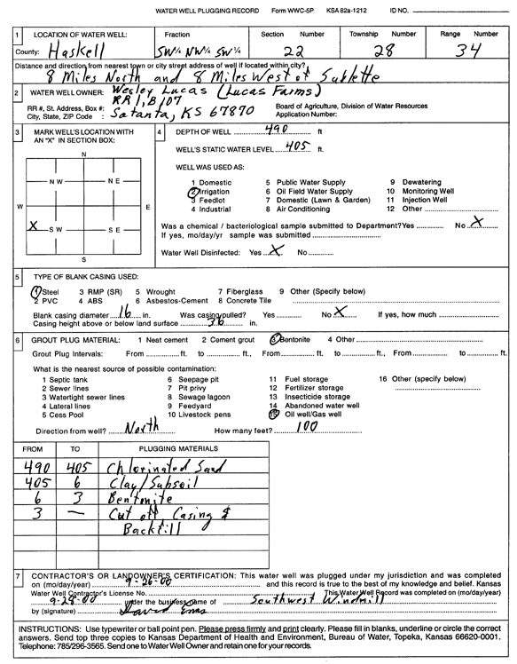
T28S, R34W, Sec. 22 SW NW SW |
Lucas, Wesley | 490 ft. | 405 ft. | Irrigation | Plugged | 26-Sep-2000 | Scan | ||
|
T28S, R34W, Sec. 22 NW SW NW |
Sprunger, Logan/Tomlinson Oil | 540 ft. | 342 ft. | 100 gpm. | Oil Field Water Supply | Sprunger 3 | Constructed | 24-Feb-1988 | |
|
T28S, R34W, Sec. 22 C SE SW |
Tomlinson Oil Inc | 400 ft. | 300 ft. | 40 gpm. | Oil Field Water Supply | Constructed | 26-Feb-1984 | ||
|
T28S, R34W, Sec. 23 SE SE SE |
Eubank, Paul and Terry | 510 ft. | 279 ft. | 1216 gpm. | Irrigation | Constructed | 04-Aug-1975 | ||
|
T28S, R34W, Sec. 24 SW SW SW SE |
Cattle Empire | 477 ft. | 390 ft. | Irrigation | Plugged | 27-Jun-2018 | |||
|
T28S, R34W, Sec. 24 NW SE NW |
Eubank, Paul and Terry | 520 ft. | 291 ft. | 1500 gpm. | Irrigation | Constructed | 24-Apr-1978 | ||
|
T28S, R34W, Sec. 24 SE SE SW |
Tice Cattle Company | 535 ft. | 357 ft. | Feedlot | Constructed | 30-Jun-1993 | |||
|
T28S, R34W, Sec. 25 SE SE NE |
Service Drilling Co | 380 ft. | 255 ft. | 50 gpm. | Oil Field Water Supply | Lemon 1-25 | Constructed | 29-Mar-1975 | |
|
T28S, R34W, Sec. 25 SW SW NE |
Tice Cattle Co. | 565 ft. | 372 ft. | Feedlot | Constructed | 25-Nov-2000 | Scan | ||
|
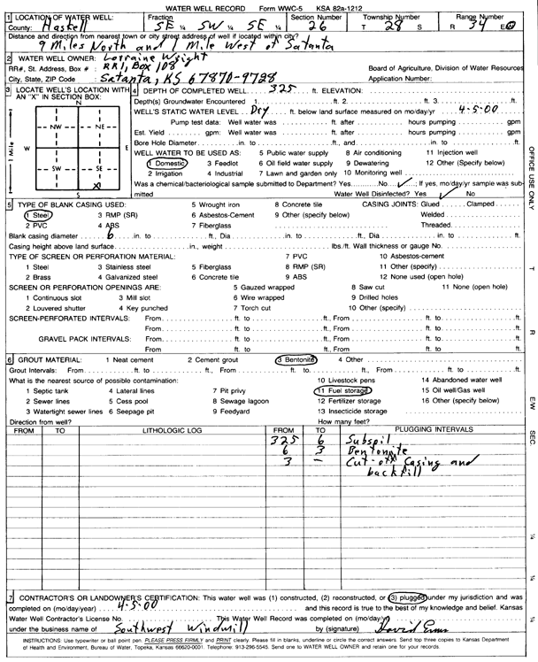
T28S, R34W, Sec. 26 SW SW SE |
Wright, Lorraine | 500 ft. | 310 ft. | 20 gpm. | Domestic | Constructed | 05-Dec-1990 | ||
|
T28S, R34W, Sec. 26 SW SW SE |
Wright, Lorraine | 510 ft. | 300 ft. | Irrigation | Plugged | 05-Dec-1990 | |||
|
T28S, R34W, Sec. 26 SW SW SE |
Wright, Lorraine | 510 ft. | 310 ft. | Domestic | Plugged | 05-Dec-1990 | |||
|
T28S, R34W, Sec. 26 SW SW SE |
Wright, Lorraine | 500 ft. | 310 ft. | 20 gpm. | Domestic | Constructed | 05-Dec-1990 | ||
|
T28S, R34W, Sec. 26 SE SW SE |
Wright, Lorraine | 325 ft. | Domestic | Plugged | 05-Apr-2000 | Scan | |||
|
T28S, R34W, Sec. 26 SW SW SE |
Wright, Lorraine | 510 ft. | 301 ft. | 20 gpm. | Domestic | Constructed | 28-Aug-1989 | ||
|
T28S, R34W, Sec. 26 SW SE SW |
Wright, Philo | 455 ft. | 260 ft. | 1600 gpm. | Irrigation | Constructed | 31-May-1977 | ||
|
T28S, R34W, Sec. 26 SE NE NE |
Wright, Philo Jr./ Mobil Oil Corp. | 440 ft. | 328 ft. | 100 gpm. | Oil Field Water Supply | Frank McCoy 1 | Plugged | 31-Mar-1988 | |
|
T28S, R34W, Sec. 26 SE NE NE |
Wright, Philo Jr/ Mobil Oil Corp. | 440 ft. | 328 ft. | 100 gpm. | Oil Field Water Supply | Frank McCoy 1 | Constructed | 09-Feb-1988 | |
|
T28S, R34W, Sec. 27 C SW SW |
Beredco Drilling | 400 ft. | 380 ft. | 80 gpm. | Oil Field Water Supply | Doerksen 4-27 | Constructed | 06-Nov-1991 | |
|
T28S, R34W, Sec. 27 SW SW NW |
Clawson, Kirby | 530 ft. | 293 ft. | 1451 gpm. | Irrigation | Constructed | 03-Mar-1977 | ||
|
T28S, R34W, Sec. 27 SE SE NW |
Clawson, Kirby | 514 ft. | 282 ft. | 1451 gpm. | Irrigation | Constructed | 02-Mar-1977 | ||
|
T28S, R34W, Sec. 27 SE SE SE |
Doerksen, Henry H. | 400 ft. | 291 ft. | 20 gpm. | Domestic | Constructed | 10-Sep-1987 | ||
|
T28S, R34W, Sec. 27 SE SE SE SW |
Linn Operating Inc. | 348 ft. | 340 ft. | Dewatering | 92-50 | Plugged | 24-Oct-2016 |
KOLAR |
|
|
T28S, R34W, Sec. 27 C SW SW |
McCoy Petroleum Corp | 400 ft. | 380 ft. | Oil Field Water Supply | Doerksen A 4-27 | Plugged | 06-Dec-1991 | ||
|
T28S, R34W, Sec. 27 NW SW SW |
Stanton, Lawrence | 535 ft. | 280 ft. | 1800 gpm. | Irrigation | Constructed | 10-Apr-1977 | ||
|
T28S, R34W, Sec. 27 SE SE SE |
SW Windmill | 520 ft. | 290 ft. | 60 gpm. | Domestic | Constructed | 18-Mar-2009 | ||
|
T28S, R34W, Sec. 27 C SE SE |
Sweetman Drilling Co/McCoy Petroleum Corp | 420 ft. | 295 ft. | Public Water Supply | Doerksen A 1-27 | Plugged | 24-Oct-1991 | ||
|
T28S, R34W, Sec. 27 C SE SE |
Sweetman Drilling Inc | 420 ft. | 295 ft. | 100 gpm. | Oil Field Water Supply | Constructed | 16-Dec-1990 | ||
|
T28S, R34W, Sec. 28 SE SE SE |
Lightcap, Gerald | 520 ft. | 372 ft. | Domestic | Constructed | 10-Apr-1997 | |||
|
T28S, R34W, Sec. 29 SW SE NW |
Barnhardt, Braden | 477 ft. | 446 ft. | Irrigation | Plugged | 23-Oct-2025 |
KOLAR |
||
|
T28S, R34W, Sec. 29 SW SE NE |
Gerald L Lightcap Trust | 514 ft. | 403 ft. | Irrigation | Plugged | 23-Oct-2025 |
KOLAR |
||
|
T28S, R34W, Sec. 29 SE SE SE |
Hicks, Russell | 495 ft. | 260 ft. | Domestic | Constructed | 15-Oct-1984 | |||
|
T28S, R34W, Sec. 29 SE SE SE |
Lightcap, Gerald | 496 ft. | 281 ft. | 35 gpm. | Domestic | Constructed | 04-Jun-1976 | ||
|
T28S, R34W, Sec. 29 SE |
Lightcap, Gerald | 520 ft. | Irrigation | Constructed | 24-Mar-1980 | ||||
|
T28S, R34W, Sec. 30 SE SE NE |
Green, Robert | 502 ft. | 264 ft. | 600 gpm. | Irrigation | Constructed | 16-May-1975 | ||
|
T28S, R34W, Sec. 30 SW SE SE |
Hicks, Robert | 510 ft. | 340 ft. | 5 gpm. | Domestic | Constructed | 29-Jul-2011 | ||
|
T28S, R34W, Sec. 30 SW SE SE |
Hicks, Robert | 710 ft. | Domestic | Constructed | 09-Dec-2011 | ||||
|
T28S, R34W, Sec. 31 SE NE NE |
SW Windmill | 480 ft. | 350 ft. | 75 gpm. | Domestic | Constructed | 14-May-2009 | ||
|
T28S, R34W, Sec. 32 NE SE SE |
Lightcap, Gerald | 525 ft. | 260 ft. | Irrigation | Constructed | 28-Apr-1978 | |||
|
T28S, R34W, Sec. 33 C NE SW |
Wright, Gail/Helmerick and Payne | 440 ft. | 287 ft. | 50 gpm. | Oil Field Water Supply | Eubank A 1 | Constructed | 22-Sep-1984 | |
|
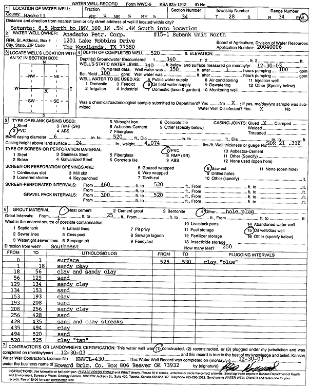
T28S, R34W, Sec. 34 NE NE SE |
Anadarko Petroleum Corp. | 520 ft. | 340 ft. | 100 gpm. | Oil Field Water Supply | 15-1 Eubank Unit North | Constructed | 30-Dec-2003 | Scan |
|
T28S, R34W, Sec. 34 NW SW NW |
Clawson Land Partnership | 540 ft. | 387 ft. | 430 gpm. | Irrigation | Constructed | 24-Aug-2009 | ||
|
T28S, R34W, Sec. 34 C SW SW |
Clawson, Kirby/Helmerick and Payne | 460 ft. | 337 ft. | 60 gpm. | Oil Field Water Supply | Gregg 3 | Constructed | 10-Nov-1983 | |
|
T28S, R34W, Sec. 34 SW SE SE |
Doerkson, George | 480 ft. | 225 ft. | 40 gpm. | Domestic | Constructed | 21-Mar-1977 | ||
|
T28S, R34W, Sec. 35 C NW NW |
Amoco Production | 400 ft. | 295 ft. | 55 gpm. | Oil Field Water Supply | Myrtle-Lesley | Constructed | 08-Dec-1984 | |
|
T28S, R34W, Sec. 35 C NW NW |
Amoco Production | 400 ft. | 295 ft. | Oil Field Water Supply | Myrtle-Lesley | Plugged | 31-Mar-1986 | ||
|
T28S, R34W, Sec. 35 NW NW NW SE |
Cattle Empire | 325 ft. | Irrigation | Plugged | 27-Jun-2018 | ||||
| View page: < Prev || 21 || 22 || 23 || 24 || 25 || 26 || 27 || 28 || 29 || 30 || Next > | |||||||||