Select location of well to view details.
Click on column heading to sort.
|
|
|
County: Haskell Select location of well to view details. Click on column heading to sort. |
|
|
|
| View page: < Prev || 31 || 32 || 33 || 34 || 35 || 36 || 37 || 38 || 39 || 40 || Next > | |||||||||
| T-R-S | Owner | Well Depth Ascend. Desc. |
Static Water Level Ascend. Desc. |
Est. Yield Ascend. Desc. |
Well Use | Other ID | Action Taken | Completion Date Ascend. Desc. |
Scan? |
|
T30S, R31W, Sec. 10 SW |
Fry Family Farms | 400 ft. | 310 ft. | Irrigation | Plugged | 20-Nov-2014 | |||
|
T30S, R31W, Sec. 10 SE NE SW |
Fry Family Farms | 410 ft. | 310 ft. | Irrigation | Constructed | 20-Nov-2014 | |||
|
T30S, R31W, Sec. 10 NW SW NW SE |
Fry Family Farms LLC | 595 ft. | 327 ft. | 488 gpm. | Irrigation | Constructed | 06-Nov-2018 |
KOLAR |
|
|
T30S, R31W, Sec. 11 NW SW SW |
Jacobs Family Investments | 610 ft. | 322 ft. | 1690 gpm. | Irrigation | Constructed | 03-Jun-2025 |
KOLAR |
|
|
T30S, R31W, Sec. 13 NE NE NW NE |
Eva Lee Stude Trust | 625 ft. | 276 ft. | 1551 gpm. | Irrigation | Constructed | 25-Jan-2013 |
KOLAR |
|
|
T30S, R31W, Sec. 13 SW NW SW |
Patterson, Wade M. | 420 ft. | 286 ft. | Irrigation | Constructed | 17-Mar-2007 | |||
|
T30S, R31W, Sec. 13 SW SW NE |
Stude, Frank | 483 ft. | 207 ft. | 1550 gpm. | Irrigation | Constructed | 13-Jun-1980 | ||
|
T30S, R31W, Sec. 14 SE SE SE |
Hoeffner, Marlon | 485 ft. | 285 ft. | Domestic | Constructed | 29-Aug-2007 | |||
|
T30S, R31W, Sec. 14 SW NW SE |
Ward Trust | 268 ft. | 252 ft. | Irrigation | Plugged | 01-Apr-1992 | |||
|
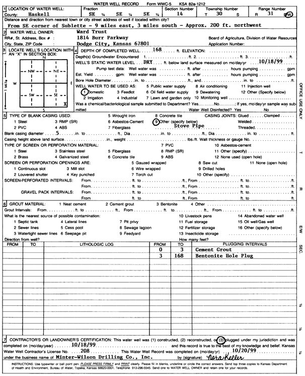
T30S, R31W, Sec. 14 SE SE SE |
Ward Trust | 168 ft. | Domestic | Plugged | 18-Oct-1999 | Scan | |||
|
T30S, R31W, Sec. 14 SE SE SE |
Ward, Grant | 300 ft. | 205 ft. | 80 gpm. | Domestic | Constructed | 12-Aug-1976 | ||
|
T30S, R31W, Sec. 15 SE SE NW |
Bryant Farms | 500 ft. | 279 ft. | Irrigation | Constructed | 14-Jul-2005 | |||
|
T30S, R31W, Sec. 15 SE SE NE |
Bryant Land and Cattle Inc. | 615 ft. | 330 ft. | 600 gpm. | Irrigation | Constructed | 06-Aug-2025 |
KOLAR |
|
|
T30S, R31W, Sec. 15 NW NW NE |
Stapleton, Leroy | 405 ft. | 265 ft. | Irrigation | Plugged | 14-Feb-1997 | |||
|
T30S, R31W, Sec. 15 SW SW NW |
Stapleton, LeRoy | 393 ft. | 215 ft. | 50 gpm. | Domestic | Constructed | 09-Jul-1978 | ||
|
T30S, R31W, Sec. 15 NW NW NE |
Stapleton, Leroy | 500 ft. | 279 ft. | 1200 gpm. | Irrigation | Constructed | 23-Oct-1996 | ||
|
T30S, R31W, Sec. 16 NE SW SE |
Banning, Ed | 450 ft. | 284 ft. | (unstated)/abandoned | Constructed | 28-Jan-2003 | Scan | ||
|
T30S, R31W, Sec. 16 SE |
Fry Family Farms | 450 ft. | 300 ft. | Irrigation | Plugged | 06-Oct-2016 | |||
|
T30S, R31W, Sec. 18 NE SE SW |
Hammer, Steve | 470 ft. | 315 ft. | 75 gpm. | Domestic | Constructed | 01-Dec-2010 | ||
|
T30S, R31W, Sec. 20 W2 NW |
Friesen Windmill and Supply/ Hammer, Robert | 380 ft. | 250 ft. | 30 gpm. | Domestic | Constructed | 24-Jul-1992 | ||
|
T30S, R31W, Sec. 20 SW SW NW NW |
Hammer, Casey | 580 ft. | 342 ft. | 50 gpm. | Domestic | Constructed | 16-Aug-2019 | ||
|
T30S, R31W, Sec. 20 SW SW NW NW |
Hammer, Casey | 580 ft. | 320 ft. | Domestic | Plugged | 06-Sep-2019 | |||
|
T30S, R31W, Sec. 20 SW SW NW |
Hammer, Cassy | 575 ft. | Domestic | Constructed | 03-Nov-2010 | ||||
|
T30S, R31W, Sec. 20 NW NW NE |
Hammer, Robert | 418 ft. | 176 ft. | 2200 gpm. | Irrigation | Constructed | 09-Apr-1975 | ||
|
T30S, R31W, Sec. 21 SE SE NW NE |
G & J Fund | 609 ft. | 342 ft. | 700 gpm. | Irrigation | Constructed | 22-Jun-2021 |
KOLAR |
|
|
T30S, R31W, Sec. 21 SW NE NE |
G & J Fund/ Unruh, Garold | 422 ft. | 267 ft. | 1300 gpm. | Irrigation | Constructed | 15-May-2001 | Scan | |
|
T30S, R31W, Sec. 22 SE NW NE |
Bryant Land and Cattle Inc. | 612 ft. | 326 ft. | 1000 gpm. | Irrigation | Constructed | 24-Jun-2025 |
KOLAR |
|
|
T30S, R31W, Sec. 22 NW NW NE NW |
Fry Family Farms LC | 610 ft. | 340 ft. | 750 gpm. | Irrigation | Constructed | 22-Oct-2019 |
KOLAR |
|
|
T30S, R31W, Sec. 22 NE NE NW NW |
Fry Family Farms LC | 429 ft. | 333.6 ft. | Irrigation | Plugged | 09-Jan-2020 |
KOLAR |
||
|
T30S, R31W, Sec. 22 N2 |
Fry Family Farms LC | 381 ft. | 330 ft. | Irrigation | Plugged | 27-Nov-2011 | |||
|
T30S, R31W, Sec. 22 NE NW NW |
Fry Family Farms LC | 435 ft. | 326 ft. | Irrigation | Constructed | 11-Dec-2011 | |||
|
T30S, R31W, Sec. 22 SW SW NE |
Miller, Alfred | 458 ft. | 218 ft. | Irrigation | Constructed | 30-Jul-1975 | |||
|
T30S, R31W, Sec. 23 C NE |
Ensign Operating | 360 ft. | 245 ft. | Oil Field Water Supply | Endsley 1-23 | Plugged | 30-Aug-1995 | ||
|
T30S, R31W, Sec. 23 C NE |
Ensign Operating | 360 ft. | 245 ft. | 75 gpm. | Oil Field Water Supply | Endsley 1-23 | Constructed | 25-Mar-1995 | |
|
T30S, R31W, Sec. 23 NW SE SE |
Rexford, Alva | 425 ft. | 198 ft. | 1300 gpm. | Irrigation | Constructed | 28-Sep-1975 | ||
|
T30S, R31W, Sec. 23 NE SW NW |
Rexford, Gary | 445 ft. | 204 ft. | 1250 gpm. | Irrigation | Constructed | 15-Oct-1975 | ||
|
T30S, R31W, Sec. 23 NW SE SE SE |
Stapleton, Twila | 555 ft. | 334 ft. | 225 gpm. | Irrigation | Constructed | 19-Dec-2012 |
KOLAR |
|
|
T30S, R31W, Sec. 23 NW NE NW |
Stapleton, Twila | 503 ft. | 265 ft. | 800 gpm. | Irrigation | Constructed | 09-Dec-1998 | Scan | |
|
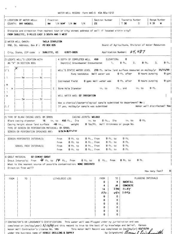
T30S, R31W, Sec. 23 NW NW NW |
Stapleton, Twila | 450 ft. | 270 ft. | Irrigation | Plugged | 15-Feb-1999 | Scan | ||
|
T30S, R31W, Sec. 24 NE NW NE |
CSS Farm Partnership | 390 ft. | 249 ft. | 950 gpm. | Irrigation | Constructed | 04-Dec-1996 | ||
|
T30S, R31W, Sec. 24 NW NW NW |
Kenneth Cory W Ltd | 360 ft. | 265 ft. | 70 gpm. | Oil Field Water Supply | CSS Farms 1-24 | Constructed | 18-Jun-2011 | |
|
T30S, R31W, Sec. 24 NW NE NW NE |
Shafer Family Farms | 379 ft. | 329 ft. | Irrigation | Plugged | 20-Nov-2020 |
KOLAR |
||
|
T30S, R31W, Sec. 24 SW NW NW NW |
Shafer Family Farms LLC | 510 ft. | 292 ft. | 1300 gpm. | Irrigation | Constructed | 31-Oct-2016 |
KOLAR |
|
|
T30S, R31W, Sec. 24 NW NW NW NE |
Shafer Family Farms LLC | 565 ft. | 323 ft. | 450 gpm. | Irrigation | Constructed | 10-Nov-2016 |
KOLAR |
|
|
T30S, R31W, Sec. 24 NW NW NW NE |
Shafer, Robert | 300 ft. | 300 ft. | Irrigation | Plugged | 24-Aug-2017 |
KOLAR |
||
|
T30S, R31W, Sec. 24 SW SW SW |
Somerville Estate | 270 ft. | Irrigation | Plugged | 02-Nov-1994 | ||||
|
T30S, R31W, Sec. 24 NE |
Sommerville, C.S. | 320 ft. | 184 ft. | 1400 gpm. | Irrigation | Constructed | 10-Jun-1975 | ||
|
T30S, R31W, Sec. 25 NE NW SE |
County Line Partnership | 520 ft. | 254 ft. | Irrigation | Constructed | 30-Jan-2002 | Scan | ||
|
T30S, R31W, Sec. 26 NW NW NW |
Schmidt, Clarence | 255 ft. | (unstated)/abandoned | Plugged | 05-Sep-1997 | ||||
|
T30S, R31W, Sec. 26 NW NW NW |
Schmidt, Clarence | 180 ft. | 150 ft. | (unstated)/abandoned | Plugged | 05-Sep-1997 | |||
| View page: < Prev || 31 || 32 || 33 || 34 || 35 || 36 || 37 || 38 || 39 || 40 || Next > | |||||||||