Select location of well to view details.
Click on column heading to sort.
|
|
|
County: Hodgeman Select location of well to view details. Click on column heading to sort. |
|
|
|
| View page: < Prev || 21 || 22 || 23 || 24 || 25 || 26 || 27 || 28 || 29 | |||||||||
| T-R-S | Owner | Well Depth Ascend. Desc. |
Static Water Level Ascend. Desc. |
Est. Yield Ascend. Desc. |
Well Use | Other ID | Action Taken | Completion Date Ascend. Desc. |
Scan? |
|
T24S, R26W, Sec. 2 SE SE NE |
Schlereth, George | 105 ft. | 51 ft. | 30 gpm. | Domestic, Livestock | Constructed | 01-May-1983 | ||
|
T24S, R26W, Sec. 2 SW NE NW |
Schlereth, George | 136 ft. | 74 ft. | 1200 gpm. | Irrigation | Constructed | 20-Jul-1975 | ||
|
T24S, R26W, Sec. 4 C SE NW |
Stauffer Chemical Co/Sage Drilling Co | 120 ft. | 70 ft. | Oil Field Water Supply | Constructed | 10-Oct-1984 | |||
|
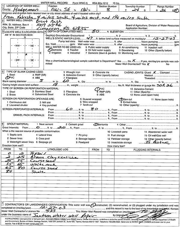
T24S, R26W, Sec. 8 NW SE NW |
Nash, Brent | 80 ft. | 47 ft. | Domestic | Constructed | 27-Dec-2003 | Scan | ||
|
T24S, R26W, Sec. 11 NE NE NW |
Harding, John | 105 ft. | 52 ft. | 35 gpm. | Domestic | Well 2 | Constructed | 22-Aug-2000 | Scan |
|
T24S, R26W, Sec. 15 NW NW SE |
Setzkorn, William | 52 ft. | 25 ft. | 10 gpm. | Domestic, Livestock | Constructed | 14-Aug-1978 | ||
|
T24S, R26W, Sec. 18 NE NW SW |
Kugler, Alan | 65 ft. | 38 ft. | Domestic, Lawn and Garden | Constructed | 30-Sep-2025 |
KOLAR |
||
|
T24S, R26W, Sec. 18 NW SE NW SW |
Kugler, Allen | 60 ft. | 36 ft. | Domestic, Livestock | Constructed | 24-Apr-2017 | |||
|
T24S, R26W, Sec. 18 SW NE NW |
Nash, Brent | 87 ft. | 58 ft. | 20 gpm. | Domestic, Livestock | Constructed | 03-Nov-2022 |
KOLAR |
|
|
T24S, R26W, Sec. 18 NE SE NE SE |
Nash, Cole | 90 ft. | 56 ft. | 25 gpm. | Domestic, Livestock | Constructed | 25-Nov-2015 | ||
|
T24S, R26W, Sec. 18 SE NW NW SE |
Nash, Cole | 76 ft. | 35 ft. | 15 gpm. | Domestic | Constructed | 27-Nov-2012 | ||
|
T24S, R26W, Sec. 19 NW SE SE |
Nash, Brent | 65 ft. | 31 ft. | 15 gpm. | Domestic | Constructed | 23-Sep-2009 | ||
|
T24S, R26W, Sec. 21 SE SE NW |
Setzkorn, Bill | 83 ft. | 65 ft. | 20 gpm. | Domestic | Constructed | 16-Sep-2010 | ||
|
T24S, R26W, Sec. 24 NW SE SE |
Vincent Oil Co. | 130 ft. | 69 ft. | Oil Field Water Supply | Constructed | 02-Oct-2009 | |||
|
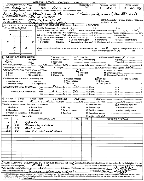
T24S, R26W, Sec. 30 NW SW NW |
Becker, Marvin | 90 ft. | 60 ft. | Domestic | Constructed | 22-Nov-2002 | Scan | ||
|
T24S, R26W, Sec. 31 NE SW SE |
Hessman, Will | 65 ft. | 14 ft. | 20 gpm. | Domestic | Constructed | 17-Jan-1983 | ||
|
T24S, R26W, Sec. 35 NW SW NW SW |
Hamilton, Todd | 56 ft. | (unstated)/abandoned | Plugged | 16-Mar-2015 | ||||
| View page: < Prev || 21 || 22 || 23 || 24 || 25 || 26 || 27 || 28 || 29 | |||||||||