Select location of well to view details.
Click on column heading to sort.
|
|
|
County: Johnson Select location of well to view details. Click on column heading to sort. |
|
|
|
| View page: 1 || 2 || 3 || 4 || 5 || 6 || 7 || 8 || 9 || 10 || Next > | |||||||||
| T-R-S | Owner | Well Depth Ascend. Desc. |
Static Water Level Ascend. Desc. |
Est. Yield Ascend. Desc. |
Well Use | Other ID | Action Taken | Completion Date Ascend. Desc. |
Scan? |
|
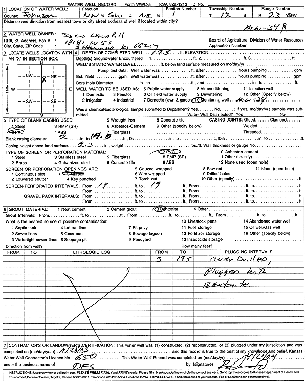
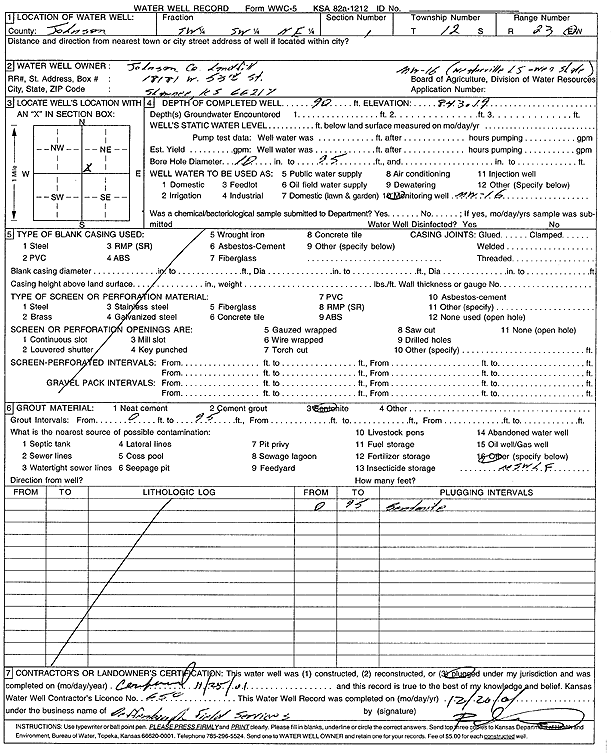
T12S, R23E, Sec. 1 NW SW NE |
Johnson County Landfill | 19.5 ft. | Monitoring well/observation/piezometer | MW 34 R | Plugged | 28-Nov-2003 | Scan | ||
|
T12S, R23E, Sec. 1 NE SW NE |
Johnson County Landfill | 41.5 ft. | 36.23 ft. | Monitoring well/observation/piezometer | MW15 R | Constructed | 16-Oct-2007 | ||
|
T12S, R23E, Sec. 1 SW NE NE |
Johnson County Landfill | 172 ft. | 140.95 ft. | Monitoring well/observation/piezometer | MW 63 | Constructed | 14-Apr-2006 | ||
|
T12S, R23E, Sec. 1 SE SE NW |
Johnson County Landfill | 181.33 ft. | 181.8 ft. | Monitoring well/observation/piezometer | 6 B 3 AS | Constructed | 26-Aug-2004 | ||
|
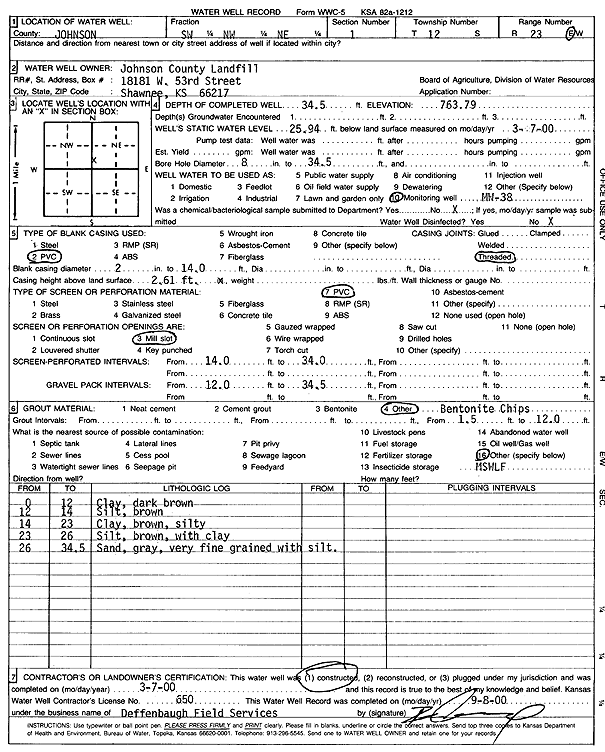
T12S, R23E, Sec. 1 SW NW NE |
Johnson County Landfill | 34.5 ft. | 25.94 ft. | Monitoring well/observation/piezometer | MW 38 | Constructed | 07-Mar-2000 | Scan | |
|
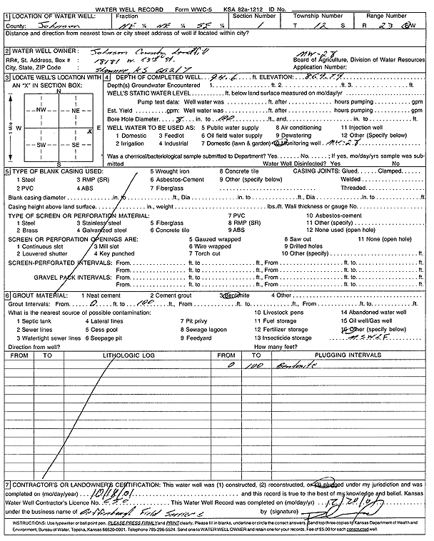
T12S, R23E, Sec. 1 NE NE SE |
Johnson County Landfill | 94.6 ft. | Monitoring well/observation/piezometer | MW 28 | Plugged | 18-Oct-2001 | Scan | ||
|
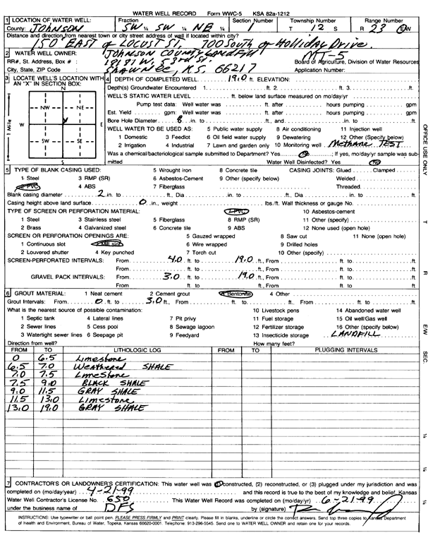
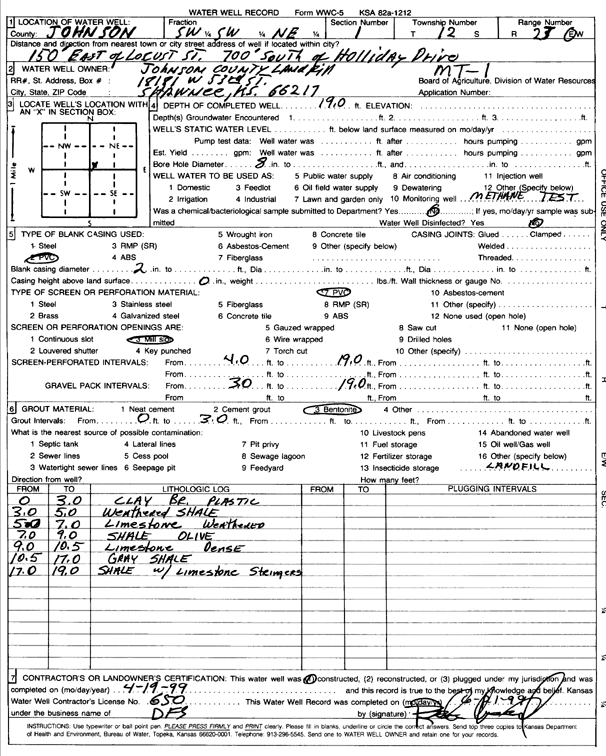
T12S, R23E, Sec. 1 SW SW NE |
Johnson County Landfill | 19 ft. | Test hole/well | MT 5 | Constructed | 21-Apr-1999 | Scan | ||
|
T12S, R23E, Sec. 1 SW SW NE |
Johnson County Landfill | 19 ft. | Test hole/well | MT 1 | Constructed | 19-Apr-1999 | Scan | ||
|
T12S, R23E, Sec. 1 SE NW SW |
Johnson County Landfill | 213.17 ft. | 136.6 ft. | Monitoring well/observation/piezometer | 6 B 4 AS | Plugged | 25-Jun-2007 | ||
|
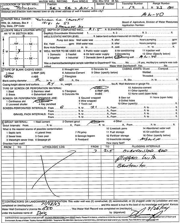
T12S, R23E, Sec. 1 SE SE NW |
Johnson County Landfill | 21.5 ft. | Monitoring well/observation/piezometer | MW 40 | Plugged | 28-Nov-2003 | Scan | ||
|
T12S, R23E, Sec. 1 SW NW NE |
Johnson County Landfill | 34.1 ft. | 22.55 ft. | Monitoring well/observation/piezometer | MW 42 | Plugged | 05-Oct-2006 | ||
|
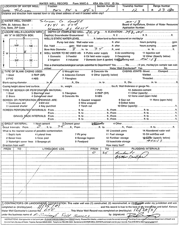
T12S, R23E, Sec. 1 SW SW NE |
Johnson County Landfill | 29.58 ft. | Monitoring well/observation/piezometer | MW 18 | Plugged | 25-Nov-2001 | Scan | ||
|
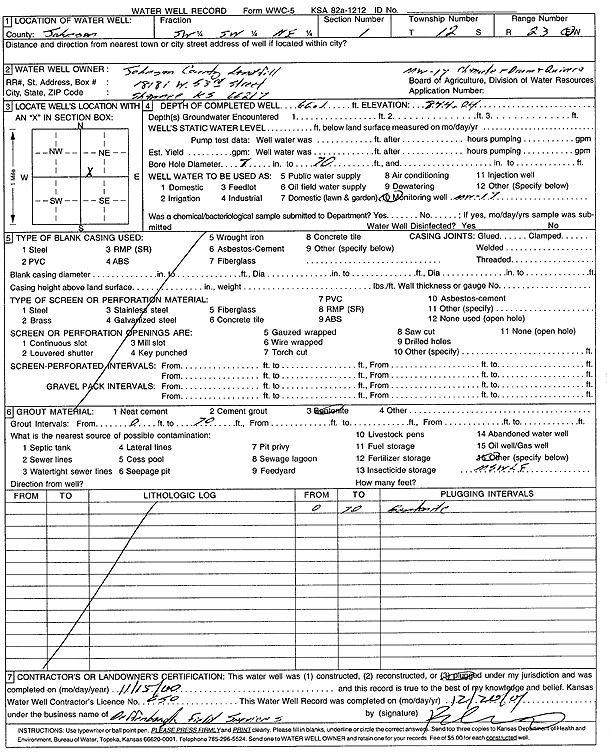
T12S, R23E, Sec. 1 SW SW NE |
Johnson County Landfill | 66.1 ft. | Monitoring well/observation/piezometer | MW 17 | Plugged | 15-Nov-2001 | Scan | ||
|
T12S, R23E, Sec. 1 SW SW NE |
Johnson County Landfill | 90 ft. | Monitoring well/observation/piezometer | MW 16 | Plugged | 25-Nov-2001 | Scan | ||
|
T12S, R23E, Sec. 1 NE SW NE |
Johnson County Landfill | 60 ft. | Monitoring well/observation/piezometer | MW 24 | Plugged | 28-Sep-2004 | |||
|
T12S, R23E, Sec. 1 NW SW NE |
Johnson County Landfill | 19.5 ft. | Monitoring well/observation/piezometer | MW 34 | Plugged | 12-Sep-2001 | Scan | ||
|
T12S, R23E, Sec. 1 SE SE NW |
Johnson County Landfill | 26 ft. | 6.1 ft. | Dewatering | SEW 1 | Plugged | 27-Nov-2006 | ||
|
T12S, R23E, Sec. 1 SE NW SW |
Johnson County Landfill | 169.83 ft. | 136.54 ft. | Monitoring well/observation/piezometer | MW 56, 6 B 4 AW | Plugged | 25-Jun-2007 | ||
|
T12S, R23E, Sec. 1 SE SE NW |
Johnson County Landfill | 69 ft. | Monitoring well/observation/piezometer | MW 49 R | Plugged | 17-Oct-2009 | |||
|
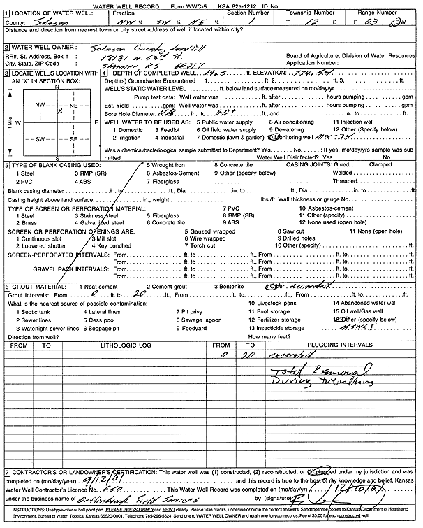
T12S, R23E, Sec. 1 NW SW NE |
Johnson County Landfill | 41.7 ft. | 38 ft. | Monitoring well/observation/piezometer | MW 15 | Constructed | 08-Aug-1991 | ||
|
T12S, R23E, Sec. 1 NE SW NE |
Johnson County Landfill | 29.5 ft. | 20 ft. | 2 gpm. | Monitoring well/observation/piezometer | MW 4 | Constructed | 03-Nov-1987 | |
|
T12S, R23E, Sec. 1 NE SW SW |
Johnson County Landfill | 143.5 ft. | Monitoring well/observation/piezometer | 6 B 6 S | Constructed | 09-May-2008 | |||
|
T12S, R23E, Sec. 1 NE SE NW |
Johnson County Landfill | 82.5 ft. | Monitoring well/observation/piezometer | 6 B 8 B | Constructed | 29-Jun-2008 | |||
|
T12S, R23E, Sec. 1 NE SE NW |
Johnson County Landfill | 92.5 ft. | Monitoring well/observation/piezometer | 6 B 8 H | Constructed | 26-Aug-2008 | |||
|
T12S, R23E, Sec. 1 NE SW NW |
Johnson County Wastewater | 90 ft. | 31 ft. | Monitoring well/observation/piezometer | ETB 101 | Plugged | 31-Dec-2013 | ||
|
T12S, R23E, Sec. 1 NE NW SW |
Smith, Robin | 60 ft. | 17 ft. | Domestic | Well 2 | Constructed | 31-Mar-2000 | Scan | |
|
T12S, R23E, Sec. 1 SW SE NW |
Smith, Robin | 120 ft. | 30 ft. | Domestic | Well 3 | Constructed | 31-Mar-2000 | Scan | |
|
T12S, R23E, Sec. 1 SE SW NW |
Smith, Robin | 120 ft. | 27 ft. | Domestic | Well 1 | Constructed | 30-Mar-2000 | Scan | |
|
T12S, R23E, Sec. 1 NE NW SW |
Smith, Robin | 140 ft. | 55 ft. | 3 gpm. | Domestic | Constructed | 28-Aug-1998 | ||
|
T12S, R23E, Sec. 1 SW SW SE NW |
Waste Management | 51 ft. | 18.06 ft. | Monitoring well/observation/piezometer | MW 70 | Constructed | 02-Oct-2017 |
KOLAR |
|
|
T12S, R23E, Sec. 1 NE SE NE SE |
Waste Management | 132 ft. | 72 ft. | Monitoring well/observation/piezometer | MW 65 | Plugged | 19-Sep-2017 |
KOLAR |
|
|
T12S, R23E, Sec. 1 NE NW SW SW |
Waste Management | 128 ft. | 51 ft. | Monitoring well/observation/piezometer | MW 6B6H | Plugged | 20-Sep-2017 |
KOLAR |
|
|
T12S, R23E, Sec. 1 SW NE NW SW |
Waste Management | 154 ft. | 94 ft. | Monitoring well/observation/piezometer | MW 6B7S | Plugged | 20-Sep-2017 |
KOLAR |
|
|
T12S, R23E, Sec. 1 NW NW SE NE |
Waste Management | 59 ft. | 52 ft. | Monitoring well/observation/piezometer | MW 24R | Plugged | 20-Sep-2017 |
KOLAR |
|
|
T12S, R23E, Sec. 1 NE SE SE NW |
Waste Management | 130 ft. | 95 ft. | Monitoring well/observation/piezometer | MW 61 | Plugged | 28-Sep-2017 |
KOLAR |
|
|
T12S, R23E, Sec. 1 NW SE NW SW |
Waste Management | 170 ft. | 146 ft. | Monitoring well/observation/piezometer | MW-56R | Plugged | 03-Oct-2017 |
KOLAR |
|
|
T12S, R23E, Sec. 1 NE NW NE SW |
Waste Management | 207 ft. | 163 ft. | Monitoring well/observation/piezometer | MW 53 | Plugged | 29-Sep-2017 |
KOLAR |
|
|
T12S, R23E, Sec. 1 NW NW NE SW |
Waste Management | 188 ft. | 151 ft. | Monitoring well/observation/piezometer | MW 54 | Plugged | 29-Sep-2017 |
KOLAR |
|
|
T12S, R23E, Sec. 1 NE SE SE NW |
Waste Management | 183 ft. | 99 ft. | Monitoring well/observation/piezometer | MW 6B3AS | Plugged | 29-Sep-2017 |
KOLAR |
|
|
T12S, R23E, Sec. 1 NE SE SE NW |
Waste Management | 126 ft. | 92 ft. | Monitoring well/observation/piezometer | MW 61R | Plugged | 29-Sep-2017 |
KOLAR |
|
|
T12S, R23E, Sec. 1 NW NE SE NE |
Waste Management | 130 ft. | 125 ft. | Monitoring well/observation/piezometer | MW 25 | Plugged | 27-Sep-2017 |
KOLAR |
|
|
T12S, R23E, Sec. 1 NW SE SE NW |
Waste Management | 82 ft. | 28 ft. | Monitoring well/observation/piezometer | MW 6B8B | Plugged | 20-Sep-2017 |
KOLAR |
|
|
T12S, R23E, Sec. 1 NW SW SW NE |
Waste Management | 138 ft. | 96 ft. | Monitoring well/observation/piezometer | MW 50R | Plugged | 29-Sep-2017 |
KOLAR |
|
|
T12S, R23E, Sec. 1 NW SE SE NW |
Waste Management | 98 ft. | 90 ft. | Monitoring well/observation/piezometer | MW 46 | Plugged | 28-Sep-2017 |
KOLAR |
|
|
T12S, R23E, Sec. 1 NW SE SE NW |
Waste Management | 93 ft. | 25 ft. | Monitoring well/observation/piezometer | MW 6B8H | Plugged | 20-Sep-2017 |
KOLAR |
|
|
T12S, R23E, Sec. 1 NE SE SW SW |
Waste Management | 252 ft. | 159 ft. | Monitoring well/observation/piezometer | MW 6B5AS | Plugged | 20-Sep-2017 |
KOLAR |
|
|
T12S, R23E, Sec. 1 NE SE SE NW |
Waste Management | 68 ft. | 64 ft. | Monitoring well/observation/piezometer | MW 49R2 | Plugged | 28-Sep-2017 |
KOLAR |
|
|
T12S, R23E, Sec. 1 NE NE NE SW |
Waste Management | 223 ft. | 185 ft. | Monitoring well/observation/piezometer | MW 52 | Plugged | 27-Sep-2017 |
KOLAR |
|
|
T12S, R23E, Sec. 1 SE SE SW NW |
Waste Management | 54 ft. | 23.23 ft. | Monitoring well/observation/piezometer | MW 69 | Constructed | 03-Oct-2017 |
KOLAR |
|
|
T12S, R23E, Sec. 1 NW SE SE NW |
Waste Management | 72 ft. | 61 ft. | Monitoring well/observation/piezometer | MW 47 | Plugged | 28-Sep-2017 |
KOLAR |
|
| View page: 1 || 2 || 3 || 4 || 5 || 6 || 7 || 8 || 9 || 10 || Next > | |||||||||