Select location of well to view details.
Click on column heading to sort.
|
|
|
County: Kearny Select location of well to view details. Click on column heading to sort. |
|
|
|
| View page: < Prev || 21 || 22 || 23 || 24 || 25 || 26 || 27 || 28 || 29 || 30 || Next > | |||||||||
| T-R-S | Owner | Well Depth Ascend. Desc. |
Static Water Level Ascend. Desc. |
Est. Yield Ascend. Desc. |
Well Use | Other ID | Action Taken | Completion Date Ascend. Desc. |
Scan? |
|
T25S, R35W, Sec. 13 SE NW SE |
Triple T Farms | 341 ft. | 61 ft. | 1288 gpm. | Irrigation | Constructed | 30-Nov-1975 | ||
|
T25S, R35W, Sec. 13 C SE NE |
Triple T Farms | 220 ft. | 50 ft. | Oil Field Water Supply | Plugged | 06-Dec-1993 | |||
|
T25S, R35W, Sec. 13 C SE NE |
Triple T Farms | 220 ft. | 81 ft. | Oil Field Water Supply | Constructed | 03-Nov-1993 | |||
|
T25S, R35W, Sec. 13 SW NE SW |
Triple T Farms | 386 ft. | 66 ft. | 1410 gpm. | Irrigation | Constructed | 30-Nov-1975 | ||
|
T25S, R35W, Sec. 13 NW SE NW |
Triple T Farms | 383 ft. | 64 ft. | 1420 gpm. | Irrigation | Constructed | 30-Nov-1975 | ||
|
T25S, R35W, Sec. 13 NE SW NE |
Triple T Farms | 366 ft. | 67 ft. | 1227 gpm. | Irrigation | Constructed | 30-Nov-1976 | ||
|
T25S, R35W, Sec. 13 SE SW SW |
Wheatland Electric Cooperative | 410 ft. | 285 ft. | Irrigation | Constructed | 10-May-2013 | |||
|
T25S, R35W, Sec. 13 SW NE SW |
Wheatland Electric Cooperative | 386 ft. | 285 ft. | Irrigation | Plugged | 01-May-2013 | |||
|
T25S, R35W, Sec. 13 SW NW NE |
Yost, Chris | 410 ft. | 196 ft. | Irrigation | Constructed | 26-Mar-2004 | Scan | ||
|
T25S, R35W, Sec. 14 SW SW NE SW |
Graham Farms Inc. | 340 ft. | 294 ft. | Irrigation | Plugged | 26-May-2017 | |||
|
T25S, R35W, Sec. 14 SW NW SW |
Graham Farms Inc. | 390 ft. | 292 ft. | Irrigation | Constructed | 23-May-2014 | |||
|
T25S, R35W, Sec. 14 SW SW NE SE |
Graham Farms Inc. | 332 ft. | 282 ft. | Irrigation | Plugged | 26-May-2017 | |||
|
T25S, R35W, Sec. 14 SW NW SE |
H and W Enterprises, LLC | 380 ft. | 287 ft. | Irrigation | Constructed | 10-Jun-2011 | |||
|
T25S, R35W, Sec. 14 SE SE NE |
H and W Enterprises, LLC | 585 ft. | 217 ft. | Irrigation | Constructed | 29-Mar-2007 | |||
|
T25S, R35W, Sec. 14 E2 W2 SE |
McCoy Petroleum | 280 ft. | 140 ft. | Oil Field Water Supply | Plugged | 23-Mar-1993 | |||
|
T25S, R35W, Sec. 14 SW SW SE |
McCoy Petroleum Corp | 220 ft. | 122 ft. | Oil Field Water Supply | Plugged | 06-Sep-1990 | |||
|
T25S, R35W, Sec. 14 SE SE SE |
McCoy Petroleum Corp. | 280 ft. | 145 ft. | Oil Field Water Supply | Campbell Trust 1-14 | Plugged | 24-Jan-1992 | ||
|
T25S, R35W, Sec. 14 SE SE SE |
Sweetman Drilling Co. | 220 ft. | 122 ft. | 110 gpm. | Oil Field Water Supply | Constructed | 07-Aug-1990 | ||
|
T25S, R35W, Sec. 14 E2 W2 SE |
Sweetman Drilling Co. | 280 ft. | 140 ft. | 110 gpm. | Oil Field Water Supply | Campbell Trust 3-14 | Constructed | 06-Nov-1992 | |
|
T25S, R35W, Sec. 14 C N2 S2 NW |
Tate, George H., III | 385 ft. | 184 ft. | Irrigation | Constructed | 01-Apr-2003 | Scan | ||
|
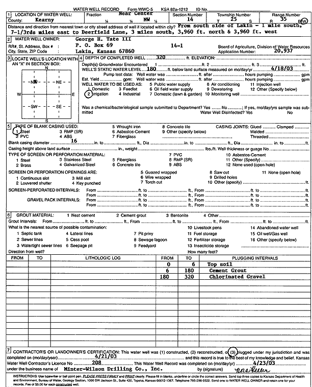
T25S, R35W, Sec. 14 C NW |
Tate, George H., III | 320 ft. | 180 ft. | Irrigation | Plugged | 21-Apr-2003 | Scan | ||
|
T25S, R35W, Sec. 14 SE SE SE |
Tate, George/Sweetman Drilling/McCoy Petro | 280 ft. | 145 ft. | 100 gpm. | Oil Field Water Supply | Campbell Trust 1-14 | Constructed | 07-Jun-1989 | |
|
T25S, R35W, Sec. 15 NE SE SW NE |
Graham Farms Inc. | 611 ft. | 277 ft. | 802 gpm. | Irrigation | Constructed | 22-Apr-2020 |
KOLAR |
|
|
T25S, R35W, Sec. 15 SE NW NW SW |
Graham Farms Inc. | 661 ft. | 284 ft. | 900 gpm. | Irrigation | Constructed | 15-Apr-2019 |
KOLAR |
|
|
T25S, R35W, Sec. 15 SW SW NE SE |
Graham Farms Inc. | 380 ft. | 275 ft. | Irrigation | Plugged | 11-Dec-2015 | |||
|
T25S, R35W, Sec. 15 SE NW SE |
Graham Farms Inc. | 465 ft. | 246 ft. | Irrigation | Test 1 | Constructed | 20-Dec-2012 | ||
|
T25S, R35W, Sec. 15 SW SW SW NE |
Triple T Farms | 350 ft. | 130 ft. | Domestic, Livestock | Constructed | 05-May-1993 | |||
|
T25S, R35W, Sec. 16 SW |
Graham Farms Inc. | 435 ft. | 282 ft. | Irrigation | Constructed | 22-May-2012 | |||
|
T25S, R35W, Sec. 16 NE SW NE |
Tate, Brad | 334 ft. | 100 ft. | Domestic | Constructed | 31-Aug-1976 | |||
|
T25S, R35W, Sec. 16 SW NE SW |
Triple T Farms | 370 ft. | 75 ft. | 1430 gpm. | Irrigation | Constructed | 30-Nov-1975 | ||
|
T25S, R35W, Sec. 16 SE NW SE |
Triple T Farms | 410 ft. | 79 ft. | 1280 gpm. | Irrigation | Constructed | 30-Nov-1975 | ||
|
T25S, R35W, Sec. 16 NE SW NE |
Triple T Farms | 400 ft. | 62 ft. | 1200 gpm. | Irrigation | Constructed | 31-Oct-1975 | ||
|
T25S, R35W, Sec. 16 NW SE NW |
Triple T Farms | 375 ft. | 67 ft. | 1400 gpm. | Irrigation | Constructed | 30-Nov-1975 | ||
|
T25S, R35W, Sec. 17 SW NE |
C C Cattle Co | 335 ft. | 54 ft. | 1200 gpm. | Irrigation | Constructed | 29-Jan-1975 | ||
|
T25S, R35W, Sec. 17 C NW |
Murfin Drilling | 250 ft. | 105 ft. | 60 gpm. | Oil Field Water Supply | Campbell 6-1 | Constructed | 07-Aug-1987 | |
|
T25S, R35W, Sec. 18 NW SE NE |
Johnson, Glen | 566 ft. | 166 ft. | Irrigation | Constructed | 22-Feb-2008 | |||
|
T25S, R35W, Sec. 18 NE |
Johnson, Glenn | 402 ft. | 163 ft. | Irrigation | Plugged | 06-Aug-2009 | |||
|
T25S, R35W, Sec. 18 SE SE NW NW |
Lakin Dairy | 549 ft. | 229 ft. | 903 gpm. | Irrigation | Constructed | 18-Apr-2019 |
KOLAR |
|
|
T25S, R35W, Sec. 18 NE NE SW SW |
Lakin Dairy | 561 ft. | 212 ft. | 738 gpm. | Irrigation | Constructed | 06-Mar-2019 |
KOLAR |
|
|
T25S, R35W, Sec. 18 NW NW SE SE |
Lakin Dairy | 581 ft. | 241 ft. | 645 gpm. | Irrigation | Constructed | 28-Feb-2017 |
KOLAR |
|
|
T25S, R35W, Sec. 18 SW NE SW |
Minter-Wilson Drilling Co | 385 ft. | 64 ft. | 1297 gpm. | Irrigation | Constructed | 26-Jan-1976 | ||
|
T25S, R35W, Sec. 18 NW SE NW |
Minter-Wilson Drilling Co | 366 ft. | 35 ft. | 1245 gpm. | Irrigation | Constructed | 26-Jan-1976 | ||
|
T25S, R35W, Sec. 19 SE SE NW SW |
Church of God in Christ Mennonite Inc. | 545 ft. | 302 ft. | 614 gpm. | Irrigation | Constructed | 28-Jun-2013 |
KOLAR |
|
|
T25S, R35W, Sec. 19 NE SW SE |
Lakin Dairy | 532 ft. | 190 ft. | Irrigation | Constructed | 20-Mar-2009 | |||
|
T25S, R35W, Sec. 19 SW SE NE |
Lakin Dairy | 490 ft. | 283 ft. | Irrigation | Constructed | 29-Jun-2012 | |||
|
T25S, R35W, Sec. 19 SE SE NW |
Nichols, David K. and Shawna | 550 ft. | 170 ft. | Irrigation | Constructed | 09-Aug-2005 | |||
|
T25S, R35W, Sec. 20 SW NW NW |
Blue House Family Trust | 390 ft. | 200 ft. | Irrigation | Constructed | 27-May-2010 | |||
|
T25S, R35W, Sec. 20 SWNENW |
Murfin Drilling | 240 ft. | 115 ft. | 65 gpm. | Oil Field Water Supply | Camel 14-1 | Constructed | 23-May-1988 | |
|
T25S, R35W, Sec. 20 SW NE NW |
Murfin Drilling | 240 ft. | 115 ft. | Oil Field Water Supply | Camel 14-1 | Plugged | 15-Jun-1988 | ||
|
T25S, R35W, Sec. 20 SW NE SW |
Thornbrough, Wayne | 378 ft. | 57 ft. | 1325 gpm. | Irrigation | C 5 | Constructed | 30-Apr-1976 | |
| View page: < Prev || 21 || 22 || 23 || 24 || 25 || 26 || 27 || 28 || 29 || 30 || Next > | |||||||||