Select location of well to view details.
Click on column heading to sort.
|
|
|
County: Kearny Select location of well to view details. Click on column heading to sort. |
|
|
|
| View page: < Prev || 31 || 32 || 33 || 34 || 35 || 36 || 37 || 38 || 39 || 40 || Next > | |||||||||
| T-R-S | Owner | Well Depth Ascend. Desc. |
Static Water Level Ascend. Desc. |
Est. Yield Ascend. Desc. |
Well Use | Other ID | Action Taken | Completion Date Ascend. Desc. |
Scan? |
|
T25S, R36W, Sec. 2 NW NW NW |
Bayliff, Richard | 200 ft. | 21 ft. | Domestic | Constructed | 18-Jul-2006 | |||
|
T25S, R36W, Sec. 2 NW SW NW |
Calderon, John Jr. | 270 ft. | 16 ft. | 50 gpm. | Domestic | Constructed | 12-Feb-1988 | ||
|
T25S, R36W, Sec. 2 NW NW NW |
Calkins, Roger | 38 ft. | 17 ft. | Domestic | Plugged | 02-Aug-1996 | |||
|
T25S, R36W, Sec. 2 NW NW NW |
Combs, Jim | 225 ft. | 24 ft. | 35 gpm. | Domestic | Constructed | 04-Apr-1984 | ||
|
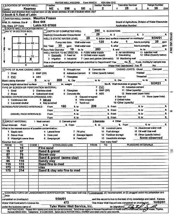
T25S, R36W, Sec. 2 NE SW SE |
Frazen, Maurice | 200 ft. | 25 ft. | 30 gpm. | Domestic | Constructed | 04-Sep-2001 | Scan | |
|
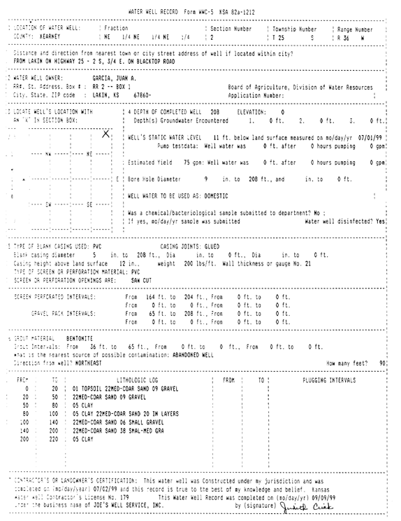
T25S, R36W, Sec. 2 NE NE NE |
Garcia, Juan A. | 208 ft. | 11 ft. | 75 gpm. | Domestic | Constructed | 02-Jul-1999 | Scan | |
|
T25S, R36W, Sec. 2 NE NE NW |
Hagman, Fred | 260 ft. | 29 ft. | Domestic | Constructed | 15-Aug-1980 | |||
|
T25S, R36W, Sec. 2 NW NW SW |
Harris, Doug | 293 ft. | 17 ft. | 20 gpm. | Domestic | Constructed | 02-Aug-1984 | ||
|
T25S, R36W, Sec. 2 SW SW NE |
Lucas, Mildred | 80 ft. | 15 ft. | Irrigation | Plugged | 22-Dec-1994 | |||
|
T25S, R36W, Sec. 2 SE |
Lucas, Richard | 273 ft. | 26 ft. | 1500 gpm. | Irrigation | Constructed | 30-Jun-1978 | ||
|
T25S, R36W, Sec. 2 NE NE NW |
Roberts, Larry | 260 ft. | 21 ft. | Domestic | Constructed | 28-Aug-1980 | |||
|
T25S, R36W, Sec. 2 SE NW NW |
Seeger, Earl | 273 ft. | 17 ft. | 20 gpm. | Domestic | Constructed | 25-Jul-1984 | ||
|
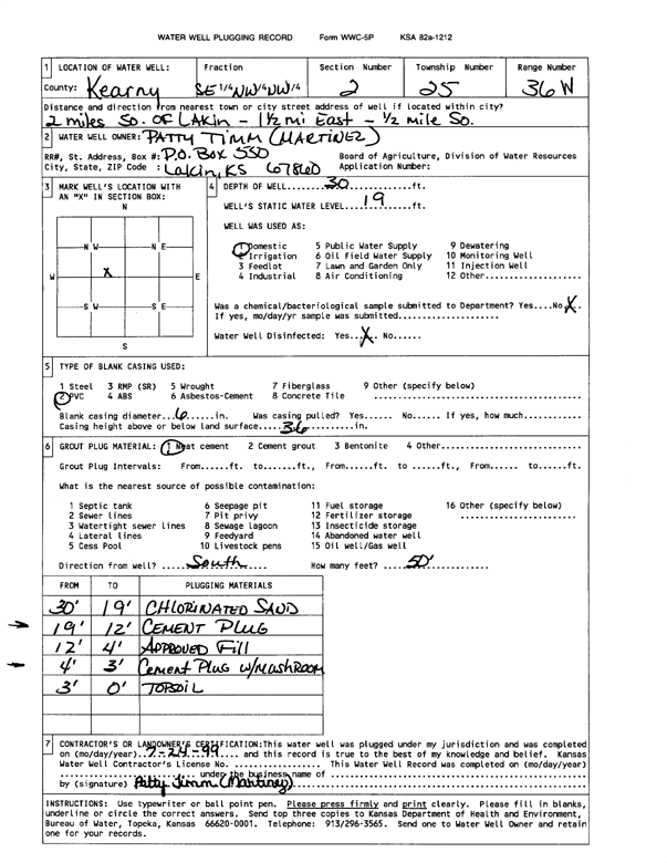
T25S, R36W, Sec. 2 SE NW NW |
Timm (Martinez), Patty | 30 ft. | 19 ft. | Domestic | Plugged | 24-Jul-1999 | Scan | ||
|
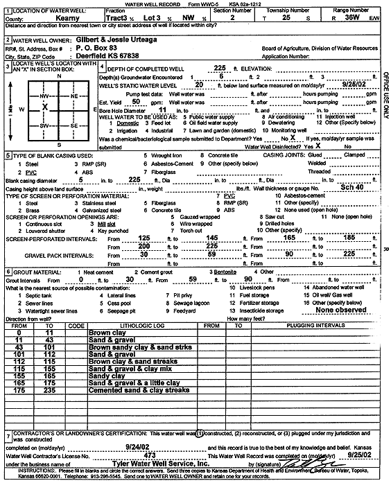
T25S, R36W, Sec. 2 NW |
Urtaega, Gilbert and Jessie | 225 ft. | 25 ft. | 50 gpm. | Domestic | Constructed | 23-Sep-2002 | ||
|
T25S, R36W, Sec. 2 NW |
Urteaga, Gilbert and Jessie | 225 ft. | 20 ft. | 50 gpm. | Domestic | Constructed | 24-Sep-2002 | Scan | |
|
T25S, R36W, Sec. 2 NW NW NW NE |
Villanueua, Juan | 255 ft. | 37 ft. | 75 gpm. | Domestic | Constructed | 27-Oct-2015 |
KOLAR |
|
|
T25S, R36W, Sec. 3 SE NE NW |
Davis, Ed | 253 ft. | 18 ft. | 1435 gpm. | Irrigation | Constructed | 15-Apr-1976 | ||
|
T25S, R36W, Sec. 3 NW NW NW |
Kraft, Randy | 260 ft. | 28 ft. | 40 gpm. | Domestic | Constructed | 12-Jul-2024 |
KOLAR |
|
|
T25S, R36W, Sec. 3 SE NW NE |
Murfin Drilling Co. | 140 ft. | 18 ft. | Oil Field Water Supply | Thorpe 1-I | Plugged | 11-May-1988 | ||
|
T25S, R36W, Sec. 3 SE NW NE |
Murfin Drilling Co. | 140 ft. | 18 ft. | 50 gpm. | Oil Field Water Supply | Thorpe 1-I | Constructed | 07-Apr-1988 | |
|
T25S, R36W, Sec. 3 SW SW NE |
Pope Joy Construction Co. | 283 ft. | 26 ft. | Domestic | Constructed | 12-May-1975 | |||
|
T25S, R36W, Sec. 3 SW SW SW |
Warren L Boegel Trust | 295 ft. | 22 ft. | Irrigation | Constructed | 16-Jan-2009 | |||
|
T25S, R36W, Sec. 4 SE NE SE |
Davis, Charles | 260 ft. | 54 ft. | 100 gpm. | Domestic | Constructed | 17-Jul-2009 | ||
|
T25S, R36W, Sec. 4 SW NW SE |
Heeke, Merle | 62 ft. | 28 ft. | 1400 gpm. | Irrigation | Constructed | 20-Jul-1980 | ||
|
T25S, R36W, Sec. 4 NE NE SE |
Heeke, Merle | 287 ft. | 15 ft. | 20 gpm. | Domestic | Constructed | 01-May-1979 | ||
|
T25S, R36W, Sec. 4 NE SE NE |
McLain, Mrs. A. O. | 210 ft. | 47 ft. | 20 gpm. | Domestic | Constructed | 17-May-1986 | ||
|
T25S, R36W, Sec. 4 SW SW SW SW |
Speirs Sisters Farm LLC | 252 ft. | 30 ft. | 1201 gpm. | Irrigation | Constructed | 14-May-2015 |
KOLAR |
|
|
T25S, R36W, Sec. 4 SW SW SW SW |
Speirs Sisters Farm LLC | 235 ft. | 25 ft. | 1590 gpm. | Irrigation | Constructed | 14-Oct-2015 |
KOLAR |
|
|
T25S, R36W, Sec. 4 SW SW SW |
Speirs, Ruth | 27 ft. | 13 ft. | Irrigation | Plugged | 01-Apr-1994 | |||
|
T25S, R36W, Sec. 4 SW SW SW |
Speirs, Ruth | 27 ft. | 13 ft. | Irrigation | Plugged | 01-Apr-1994 | |||
|
T25S, R36W, Sec. 4 SW SW SW |
Speirs, Ruth | 27 ft. | 13 ft. | Irrigation | Plugged | 01-Apr-1994 | |||
|
T25S, R36W, Sec. 5 NE SW NW |
Smith, H.R. | 109 ft. | 13 ft. | 950 gpm. | Irrigation | Constructed | 30-Apr-1976 | ||
|
T25S, R36W, Sec. 5 NE NW SE |
Speirs, Ruth | 40 ft. | 5 ft. | Domestic, Livestock | Plugged | 01-Apr-1994 | |||
|
T25S, R36W, Sec. 5 NE SW NW |
Wall, George | 248 ft. | 14 ft. | Irrigation | Constructed | 11-Oct-2011 | |||
|
T25S, R36W, Sec. 5 NW NW NE NW |
Wall, George | 190 ft. | 18 ft. | 50 gpm. | Domestic | Constructed | 28-Oct-2016 |
KOLAR |
|
|
T25S, R36W, Sec. 6 SW NE SW |
Weisel, Inc. | 160 ft. | 15 ft. | Domestic | Constructed | 15-Jun-1993 | |||
|
T25S, R36W, Sec. 7 SW NE SW |
Beymer, Clyde | 130 ft. | 24 ft. | 1390 gpm. | Irrigation | Constructed | 30-May-1976 | ||
|
T25S, R36W, Sec. 7 SE SW SW |
Beymer, Clyde | 40 ft. | Irrigation | Plugged | 08-Oct-1994 | ||||
|
T25S, R36W, Sec. 7 SE SW SW |
Beymer, Clyde | 40 ft. | Irrigation | Plugged | 08-Oct-1994 | ||||
|
T25S, R36W, Sec. 7 SW NW SE |
Triple B Land LLC | 444 ft. | 36 ft. | 1000 gpm. | Irrigation | Constructed | 14-Jun-2023 |
KOLAR |
|
|
T25S, R36W, Sec. 9 SE NW SE |
Beymer, Elton | 292 ft. | 228 ft. | 750 gpm. | Irrigation | Constructed | 29-May-1976 | ||
|
T25S, R36W, Sec. 9 NW |
Johnson Farms Estate | 212 ft. | 25 ft. | 1675 gpm. | Irrigation | Constructed | 30-Sep-1980 | ||
|
T25S, R36W, Sec. 9 NW NW SW |
Johnson, Robert | 353 ft. | 31 ft. | 2000 gpm. | Irrigation | Constructed | 06-Aug-1984 | ||
|
T25S, R36W, Sec. 10 SW NE NE |
Beymer Water Recreation Park | 300 ft. | Domestic | Constructed | 16-Jun-1981 | ||||
|
T25S, R36W, Sec. 10 NE NE NE |
Beymer, Clyde | 18 ft. | Domestic | Plugged | 11-Mar-1995 | ||||
|
T25S, R36W, Sec. 10 SE SE SW |
Escamilla, Raymond | 230 ft. | 32 ft. | Domestic | Constructed | 06-Feb-2007 | |||
|
T25S, R36W, Sec. 10 SW NE SW |
Jones, Susan | 18 ft. | 13 ft. | Domestic | Plugged | 05-Dec-1997 | |||
|
T25S, R36W, Sec. 10 NE SW NE |
Kearny County | 244 ft. | 19 ft. | Domestic | Plugged | 30-Aug-1996 | |||
|
T25S, R36W, Sec. 10 NW SW SW |
Linenberger, Kenny | 18 ft. | Domestic | Well 3 | Plugged | 31-Dec-1994 | |||
|
T25S, R36W, Sec. 10 NW SW SW |
Linenberger, Kenny | 18 ft. | Domestic | Well 2 | Plugged | 31-Dec-1994 | |||
| View page: < Prev || 31 || 32 || 33 || 34 || 35 || 36 || 37 || 38 || 39 || 40 || Next > | |||||||||