Select location of well to view details.
Click on column heading to sort.
|
|
|
County: Kearny Select location of well to view details. Click on column heading to sort. |
|
|
|
| View page: < Prev || 31 || 32 || 33 || 34 || 35 || 36 || 37 || 38 || 39 || 40 || Next > | |||||||||
| T-R-S | Owner | Well Depth Ascend. Desc. |
Static Water Level Ascend. Desc. |
Est. Yield Ascend. Desc. |
Well Use | Other ID | Action Taken | Completion Date Ascend. Desc. |
Scan? |
|
T25S, R36W, Sec. 10 NW SW SW |
Linenberger, Kenny | 18 ft. | Domestic | Well 4 | Plugged | 31-Dec-1994 | |||
|
T25S, R36W, Sec. 10 NW SW SW |
Linenberger, Kenny | 18 ft. | Domestic | Well 1 | Plugged | 31-Dec-1994 | |||
|
T25S, R36W, Sec. 10 NE SW SW |
Murfin Drilling Co. | 220 ft. | 80 ft. | Oil Field Water Supply | Beymer 1-I | Plugged | 13-Nov-1989 | ||
|
T25S, R36W, Sec. 10 NE SW SW |
Murfin Drilling Co. | 220 ft. | 80 ft. | 90 gpm. | Oil Field Water Supply | Beymer 1-I | Constructed | 03-Nov-1989 | |
|
T25S, R36W, Sec. 10 SW SW SW |
Puckett, Forrest | 197 ft. | 15 ft. | Irrigation | Constructed | 15-Apr-1976 | |||
|
T25S, R36W, Sec. 10 SE NW SW |
Quality Hay LLC | 465 ft. | 52 ft. | 1000 gpm. | Irrigation | Constructed | 23-Jun-2023 |
KOLAR |
|
|
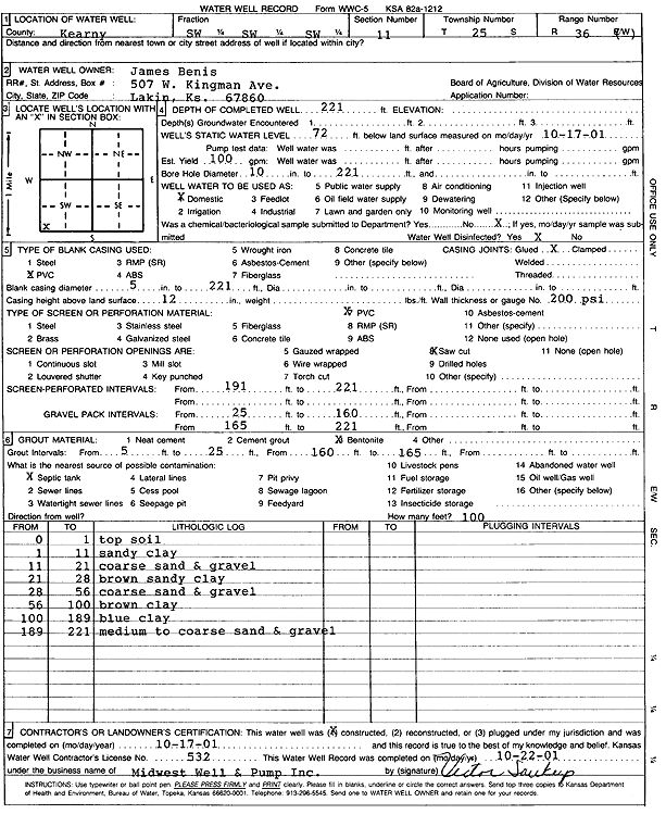
T25S, R36W, Sec. 11 SW SW SW |
Benis, James | 221 ft. | 72 ft. | 100 gpm. | Domestic | Constructed | 17-Oct-2001 | Scan | |
|
T25S, R36W, Sec. 11 SW NW SW |
Coder, Willard | 79 ft. | 17 ft. | Irrigation | Plugged | 23-Aug-1993 | |||
|
T25S, R36W, Sec. 11 NW NW SW |
Coder, Willard | 59 ft. | 50 ft. | Domestic, Livestock | Constructed | 03-Nov-1975 | |||
|
T25S, R36W, Sec. 11 SW NW SW |
Coder, Willard | 26 ft. | Irrigation | Plugged | 23-Aug-1993 | ||||
|
T25S, R36W, Sec. 11 NW SW |
Coder, Willard | 117 ft. | 32 ft. | Irrigation | Constructed | 27-Feb-1984 | |||
|
T25S, R36W, Sec. 11 SW SW NW SW |
Hayzelett, Brandon | 275 ft. | 45 ft. | 50 gpm. | Domestic | Constructed | 16-Aug-2012 |
KOLAR |
|
|
T25S, R36W, Sec. 11 NW SW SW |
Hayzlett, Randy | 81 ft. | Domestic | Plugged | 24-Aug-1993 | ||||
|
T25S, R36W, Sec. 11 SW SW NW SW |
Hayzlett, Randy | 300 ft. | 60 ft. | 1587 gpm. | Irrigation | Constructed | 26-Jun-2013 |
KOLAR |
|
|
T25S, R36W, Sec. 11 NW SW SW |
Hayzlett, Randy | 24 ft. | Domestic | Plugged | 24-Aug-1993 | ||||
|
T25S, R36W, Sec. 11 NE SW |
Hazlett, Randy | 240 ft. | 52 ft. | Domestic | Constructed | 23-Dec-1980 | |||
|
T25S, R36W, Sec. 11 SE NW NE |
Murfin Drilling Co. | 160 ft. | 20 ft. | Oil Field Water Supply | Plugged | 14-Jun-1988 | |||
|
T25S, R36W, Sec. 11 SE NW NE |
Murfin Drilling Co. | 160 ft. | 20 ft. | 65 gpm. | Oil Field Water Supply | McCune 2-I | Constructed | 12-May-1988 | |
|
T25S, R36W, Sec. 12 NW NW SW |
CEB, Inc. | 340 ft. | 58 ft. | Irrigation | Constructed | 20-Mar-2007 | |||
|
T25S, R36W, Sec. 12 SE |
CEB, Inc. | 576 ft. | 128 ft. | Irrigation | Constructed | 17-Jan-2007 | |||
|
T25S, R36W, Sec. 12 NE SE SE SW |
Goertzen, Ryan | 420 ft. | 249 ft. | 25 gpm. | Domestic | Constructed | 07-May-2021 |
KOLAR |
|
|
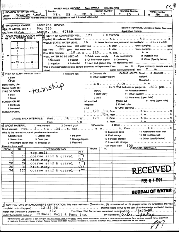
T25S, R36W, Sec. 13 NE NE NE |
Brown, Katrina | 123 ft. | 16 ft. | 100 gpm. | Domestic | Constructed | 22-Dec-1998 | Scan | |
|
T25S, R36W, Sec. 13 NE SW NW |
Goertzen, David | 581 ft. | 144 ft. | Irrigation | Constructed | 22-Mar-2007 | |||
|
T25S, R36W, Sec. 13 SE SE NE |
Goertzen, David | 350 ft. | 116 ft. | Domestic | Constructed | 01-May-1997 | |||
|
T25S, R36W, Sec. 13 SE SE NE |
Goertzen, David | 380 ft. | 206 ft. | Domestic | Constructed | 29-Jul-2005 | |||
|
T25S, R36W, Sec. 13 SW SE SE SW |
Lakin Dairy | 465 ft. | 222 ft. | 1056 gpm. | Irrigation | Constructed | 11-Mar-2020 |
KOLAR |
|
|
T25S, R36W, Sec. 13 NE NE SW SE |
Lakin Hay LLC | 570 ft. | 210 ft. | 1106 gpm. | Irrigation | Constructed | 01-Feb-2020 |
KOLAR |
|
|
T25S, R36W, Sec. 13 SE NW SE |
Minter-Wilson Drilling Co. | 425 ft. | 64 ft. | 1300 gpm. | Irrigation | Constructed | 26-Jan-1976 | ||
|
T25S, R36W, Sec. 13 NW SE NW |
Minter-Wilson Drilling Co. | 360 ft. | 50 ft. | 1050 gpm. | Irrigation | Constructed | 29-Feb-1976 | ||
|
T25S, R36W, Sec. 13 SW NE SW |
Minter-Wilson Drilling Co. | 378 ft. | 64 ft. | 1275 gpm. | Domestic | Constructed | 26-Jan-1976 | ||
|
T25S, R36W, Sec. 14 NE NE SW NE |
Fred Ritsema and Yoka Rodenhuis Trusts | 418 ft. | 170 ft. | 336 gpm. | Irrigation | Constructed | 06-Jul-2018 |
KOLAR |
|
|
T25S, R36W, Sec. 14 SW NE NW SW |
Fred Ritsema and Yoka Rodenhuis Trusts | 455 ft. | 164 ft. | 808 gpm. | Irrigation | Constructed | 27-Jun-2017 |
KOLAR |
|
|
T25S, R36W, Sec. 14 SE SE NW |
Koehn, Dennis | 320 ft. | 167 ft. | Domestic | Constructed | 02-Mar-1992 | |||
|
T25S, R36W, Sec. 14 SE NW SE |
Minter-Wilson Drilling Co. | 365 ft. | 52 ft. | 1175 gpm. | Irrigation | Constructed | 29-Feb-1976 | ||
|
T25S, R36W, Sec. 14 NW SE NW |
Minter-Wilson Drilling Co. | 380 ft. | 63 ft. | 1300 gpm. | Irrigation | 23 | Constructed | 30-Apr-1976 | |
|
T25S, R36W, Sec. 14 NE SW NE |
Minter-Wilson Drilling Co. | 363 ft. | 64 ft. | 1275 gpm. | Irrigation | 24 | Constructed | 31-Mar-1976 | |
|
T25S, R36W, Sec. 14 SW NE SW |
Minter-Wilson Drilling Co. | 313 ft. | 58 ft. | 1325 gpm. | Irrigation | Constructed | 29-Feb-1976 | ||
|
T25S, R36W, Sec. 14 NE NE SW |
Smith, Roger | 285 ft. | 136 ft. | Domestic | Constructed | 06-Apr-1991 | |||
|
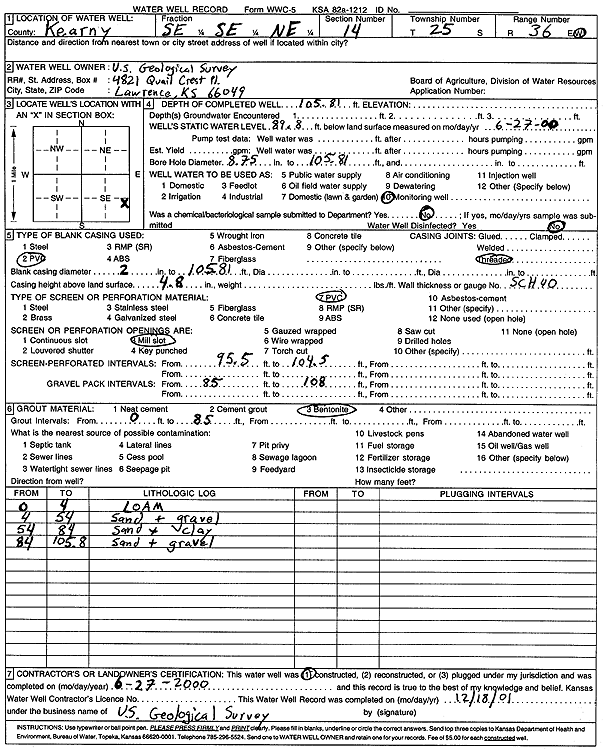
T25S, R36W, Sec. 14 SE SE NE |
U.S. Geological Survey | 105.8 ft. | 89.8 ft. | Monitoring well/observation/piezometer | Constructed | 27-Jun-2000 | Scan | ||
|
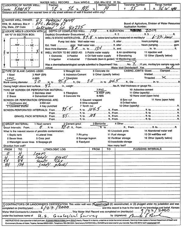
T25S, R36W, Sec. 14 SE SE NE |
U.S. Geological Survey | 124 ft. | 89.8 ft. | Monitoring well/observation/piezometer | Constructed | 27-Jun-2000 | Scan | ||
|
T25S, R36W, Sec. 15 NW NW NE |
Anderson, Ken and Judy | 250 ft. | 54 ft. | 50 gpm. | Domestic | Constructed | 21-Aug-1986 | ||
|
T25S, R36W, Sec. 15 SW NE NE |
Cooley, John W. | 223 ft. | 45 ft. | 100 gpm. | Domestic | Constructed | 21-Sep-1983 | ||
|
T25S, R36W, Sec. 15 W2 NE NW |
Counts, Kenneth | 360 ft. | 72 ft. | 40 gpm. | Domestic | Constructed | 04-Jul-1995 | ||
|
T25S, R36W, Sec. 15 SE NE NE |
Denten, Robert | 212 ft. | 40 ft. | 25 gpm. | Domestic | Constructed | 20-Mar-1987 | ||
|
T25S, R36W, Sec. 15 NE NE NW |
Francis, Susan | 245 ft. | 83 ft. | 100 gpm. | Domestic, Livestock | Constructed | 04-Apr-2012 | ||
|
T25S, R36W, Sec. 15 NW SW SE |
Jury, Michael | 246 ft. | 110 ft. | 55 gpm. | Domestic | Constructed | 17-Sep-1993 | ||
|
T25S, R36W, Sec. 15 NE SW SW |
Murfin Drilling | 260 ft. | 130 ft. | 65 gpm. | Oil Field Water Supply | Lee 2-I | Constructed | 19-Feb-1988 | |
|
T25S, R36W, Sec. 15 NE SW NE |
Randolph, Jeff | 250 ft. | 60 ft. | Domestic | Constructed | 01-Sep-1990 | |||
|
T25S, R36W, Sec. 15 SE SW SE SW |
Redger, Alex | 530 ft. | 193 ft. | 25 gpm. | Domestic | Constructed | 23-Sep-2021 |
KOLAR |
|
|
T25S, R36W, Sec. 15 NW NE NE |
Rupke, Henry | 223 ft. | 52 ft. | Domestic | Constructed | 16-May-1983 | |||
| View page: < Prev || 31 || 32 || 33 || 34 || 35 || 36 || 37 || 38 || 39 || 40 || Next > | |||||||||