Select location of well to view details.
Click on column heading to sort.
|
|
|
County: Kearny Select location of well to view details. Click on column heading to sort. |
|
|
|
| View page: < Prev || 31 || 32 || 33 || 34 || 35 || 36 || 37 || 38 || 39 || 40 || Next > | |||||||||
| T-R-S | Owner | Well Depth Ascend. Desc. |
Static Water Level Ascend. Desc. |
Est. Yield Ascend. Desc. |
Well Use | Other ID | Action Taken | Completion Date Ascend. Desc. |
Scan? |
|
T25S, R36W, Sec. 36 SW |
AI Leasing, Inc. | 259 ft. | 190 ft. | Irrigation | Plugged | 12-Jan-2009 | |||
|
T25S, R36W, Sec. 36 SW |
AI Leasing, Inc. | 265 ft. | 95 ft. | 1625 gpm. | Irrigation | Constructed | 26-May-1984 | ||
|
T25S, R36W, Sec. 36 NW NW NW |
TFT Alfalfa Farms | 480 ft. | 218 ft. | Irrigation | Constructed | 07-Oct-2010 | |||
|
T25S, R36W, Sec. 36 NW |
TFT Alfalfa Farms | 245 ft. | 195 ft. | Irrigation | Plugged | 11-Nov-2010 | |||
|
T25S, R36W, Sec. 36 SW |
Tokoi Farms | 265 ft. | 190 ft. | Irrigation | Plugged | 12-Jan-2009 | |||
|
T25S, R37W, Sec. 1 NW NE SE |
Crump, John | 193 ft. | 49 ft. | 28 gpm. | Domestic, Livestock | Constructed | 01-May-2009 | ||
|
T25S, R37W, Sec. 2 SE SE NW |
Ratzlaff Inc | 220 ft. | 140 ft. | 10 gpm. | Domestic, Livestock | Constructed | 12-Aug-1985 | ||
|
T25S, R37W, Sec. 3 SW NE SW NW |
Burch, Michael | 500 ft. | 252 ft. | 35 gpm. | Domestic, Livestock | Constructed | 26-Aug-2021 | ||
|
T25S, R37W, Sec. 3 SW NW SW NW |
Reece, Dan | 480 ft. | 251 ft. | 40 gpm. | Domestic | Constructed | 23-Aug-2021 | ||
|
T25S, R37W, Sec. 5 SE SE SE |
Barnhardt, Gordon | 193 ft. | 70 ft. | Domestic | Constructed | 21-Jun-1991 | |||
|
T25S, R37W, Sec. 5 NW NW NW |
Barnhardt, Robert Gordon | 316 ft. | 90 ft. | 15 gpm. | Domestic | Constructed | 13-Aug-1990 | ||
|
T25S, R37W, Sec. 6 NE SW NW |
Hannagan, Charles | 108 ft. | 77 ft. | Domestic | Plugged | 17-Jun-1989 | |||
|
T25S, R37W, Sec. 6 NE SW NW |
Hannagan, Charles | 290 ft. | 75 ft. | Domestic, Livestock | Constructed | 13-Jun-1989 | |||
|
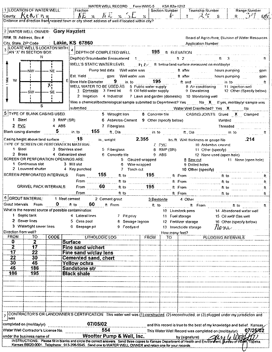
T25S, R37W, Sec. 6 NE NE SE |
Hayzlett, Gary | 195 ft. | Domestic | Constructed | 05-Jul-2002 | Scan | |||
|
T25S, R37W, Sec. 6 NW SE NW |
Simmons, Dorris | 110 ft. | 97 ft. | 3 gpm. | Domestic | Hintz 3-6 | Constructed | 29-Nov-1988 | |
|
T25S, R37W, Sec. 7 NW NE SW |
Hayzlett, Randy | 30 ft. | 4 ft. | Domestic, Livestock | Constructed | 05-May-2026 |
KOLAR |
||
|
T25S, R37W, Sec. 7 NW NE NE |
Kopfman, Jack | 199 ft. | 90 ft. | 15 gpm. | Domestic | Constructed | 11-Feb-1998 | ||
|
T25S, R37W, Sec. 8 SE SE SE |
Schmitt, Carl | 21 ft. | 3 ft. | Domestic | Plugged | 16-Dec-1996 | |||
|
T25S, R37W, Sec. 8 SW SW NW |
Schmitt, Carl | 16 ft. | Domestic | Plugged | 16-Dec-1996 | ||||
|
T25S, R37W, Sec. 8 SE SE SW |
Schmitt, Carl | 147 ft. | 40 ft. | Domestic | Constructed | 21-Sep-1994 | |||
|
T25S, R37W, Sec. 8 SW SE SW |
Schmitt, Carl | 20 ft. | 14 ft. | Irrigation | Plugged | 16-Dec-1996 | |||
|
T25S, R37W, Sec. 8 SW SE SW |
Schmitt, Carl | 20 ft. | 14 ft. | Irrigation | Plugged | 16-Dec-1996 | |||
|
T25S, R37W, Sec. 8 SE SE SE |
Schmitt, Carl | 127 ft. | 54 ft. | 10 gpm. | Domestic | Constructed | 05-Apr-1985 | ||
|
T25S, R37W, Sec. 8 SE SE SE |
Schmitt, Carl | 80 ft. | 10 ft. | Domestic | Plugged | 17-Dec-1996 | |||
|
T25S, R37W, Sec. 9 SE SE SE |
Hayzlett, Randy | 60 ft. | 40 ft. | 10 gpm. | Domestic, Livestock | Constructed | 27-Mar-1992 | ||
|
T25S, R37W, Sec. 10 SW SE SW |
Schmidt, Carl | 134 ft. | 31 ft. | Domestic | Constructed | 27-Sep-1993 | |||
|
T25S, R37W, Sec. 10 SE SE SW |
Schmitt, Carl | 12 ft. | 1 ft. | Domestic | Plugged | 16-Dec-1996 | |||
|
T25S, R37W, Sec. 11 C SW SW |
Minter-Wilson | 320 ft. | Domestic | Constructed | 18-Mar-1996 | ||||
|
T25S, R37W, Sec. 11 NW NW SE |
Rodd, Aaron | 156 ft. | 26 ft. | Domestic | Constructed | 25-Mar-2025 |
KOLAR |
||
|
T25S, R37W, Sec. 11 S2 SE |
Smith Sand Co | 55 ft. | 19 ft. | Dewatering | Constructed | 26-Sep-1980 | |||
|
T25S, R37W, Sec. 11 NE SW SW |
Smith Sand Co | 55 ft. | 19 ft. | Domestic | Constructed | 10-Jul-1981 | |||
|
T25S, R37W, Sec. 12 NE NE NE |
Novak, Dave | 310 ft. | 82 ft. | Domestic | Constructed | 09-Nov-2010 | |||
|
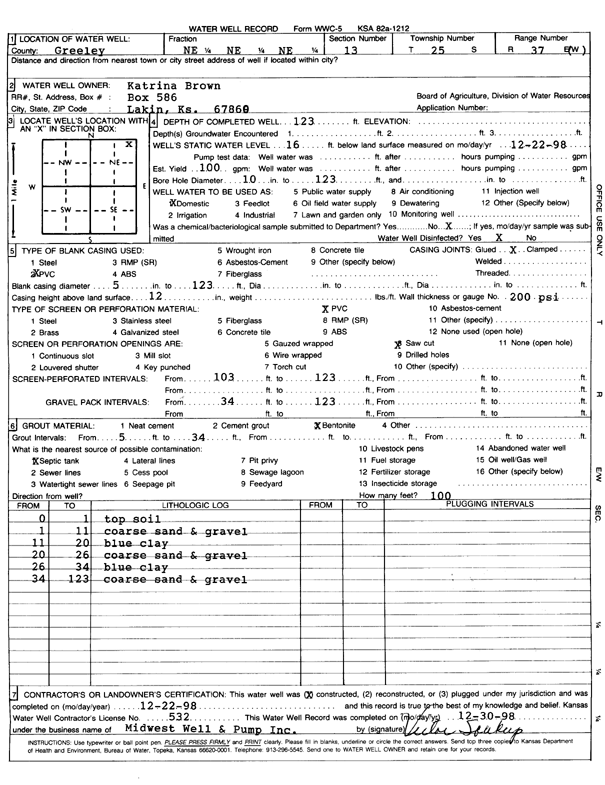
T25S, R37W, Sec. 13 NE NE NE |
Brown, Katrina | 123 ft. | 16 ft. | 100 gpm. | Domestic | Constructed | 22-Dec-1998 | Scan | |
|
T25S, R37W, Sec. 14 SW SW NE |
Fuller, Brad | 284 ft. | 47 ft. | 90 gpm. | Domestic, Livestock | Constructed | 05-Oct-1992 | ||
|
T25S, R37W, Sec. 15 SW NE NW |
Grubbs, Dennis | 120 ft. | 13 ft. | 50 gpm. | Domestic, Livestock | Constructed | 24-Nov-2023 |
KOLAR |
|
|
T25S, R37W, Sec. 15 SE NW NW |
Hazelet, Randy | 122 ft. | 13 ft. | 50 gpm. | Domestic, Livestock | Constructed | 23-Oct-2023 |
KOLAR |
|
|
T25S, R37W, Sec. 17 SE SE |
Kansas Geological Survey | 536 ft. | Monitoring well/observation/piezometer | 17 DD | Constructed | 10-Jul-1962 | |||
|
T25S, R37W, Sec. 17 SE NW NE NE |
Pepper, Jack | 520 ft. | 60 ft. | 40 gpm. | Domestic | Constructed | 28-May-2015 |
KOLAR |
|
|
T25S, R37W, Sec. 17 NW SE NE |
Schmitt, Carl | 45 ft. | 5 ft. | Irrigation | Constructed | 27-Jul-1991 | |||
|
T25S, R37W, Sec. 17 SW NE NE |
Schmitt, Carl | 41 ft. | 35 ft. | Irrigation | Plugged | 16-Dec-1996 | |||
|
T25S, R37W, Sec. 18 NW NW NW |
Triple T Farms | 280 ft. | 58 ft. | Domestic | Constructed | 26-Aug-1994 | |||
|
T25S, R37W, Sec. 19 SW NE SW |
Triple T Farms | 28 ft. | Domestic | Plugged | 08-Apr-1993 | ||||
|
T25S, R37W, Sec. 19 NE SW SW |
Triple T Farms | 40 ft. | Domestic | Plugged | 09-Apr-1983 | Scan | |||
|
T25S, R37W, Sec. 20 NE SW NE |
Triple T Farms | 32 ft. | Domestic | Plugged | 08-Apr-1993 | Scan | |||
|
T25S, R37W, Sec. 21 NE NE NE |
Triple T Farms | 37 ft. | Domestic | Plugged | 07-Apr-1993 | ||||
|
T25S, R37W, Sec. 22 NW NE SE |
Triple T Farms | 41 ft. | 31 ft. | Domestic | Plugged | 07-Apr-1993 | |||
|
T25S, R37W, Sec. 24 NW SW SW |
Kearny County Feeders | 300 ft. | 68 ft. | Domestic | Constructed | 06-Feb-1990 | |||
|
T25S, R37W, Sec. 24 NW NW SW |
Kearny County Feeders | 298 ft. | 68 ft. | Domestic | Constructed | 01-Aug-1987 | |||
|
T25S, R37W, Sec. 25 SW NE SW |
H-30 Drilling, Inc. | 180 ft. | 40 ft. | 80 gpm. | Oil Field Water Supply | Johnson 1-I | Constructed | 12-Mar-1989 | |
|
T25S, R37W, Sec. 25 SW NE SW |
H-30 Drilling, Inc. | 180 ft. | 40 ft. | 80 gpm. | Oil Field Water Supply | Johnson 1-I | Reconstructed | 30-May-1989 | |
| View page: < Prev || 31 || 32 || 33 || 34 || 35 || 36 || 37 || 38 || 39 || 40 || Next > | |||||||||