Select location of well to view details.
Click on column heading to sort.
|
|
|
County: Kearny Select location of well to view details. Click on column heading to sort. |
|
|
|
| View page: < Prev || 31 || 32 || 33 || 34 || 35 || 36 || 37 || 38 || 39 || 40 || Next > | |||||||||
| T-R-S | Owner | Well Depth Ascend. Desc. |
Static Water Level Ascend. Desc. |
Est. Yield Ascend. Desc. |
Well Use | Other ID | Action Taken | Completion Date Ascend. Desc. |
Scan? |
|
T25S, R37W, Sec. 26 NE SE NW |
Triple T Farms | 280 ft. | 183 ft. | Domestic | Constructed | 31-Jan-1997 | |||
|
T25S, R37W, Sec. 29 SE NW NE |
Triple T Farms | 50 ft. | Domestic | Plugged | 09-Apr-1993 | Scan | |||
|
T25S, R37W, Sec. 30 SW NE SW |
Triple T Farms | 50 ft. | Domestic | Plugged | 09-Apr-1993 | Scan | |||
|
T25S, R37W, Sec. 35 SE SE SE |
Kearny County Feeders | 180 ft. | 70 ft. | Domestic | Constructed | 11-Jul-1990 | |||
|
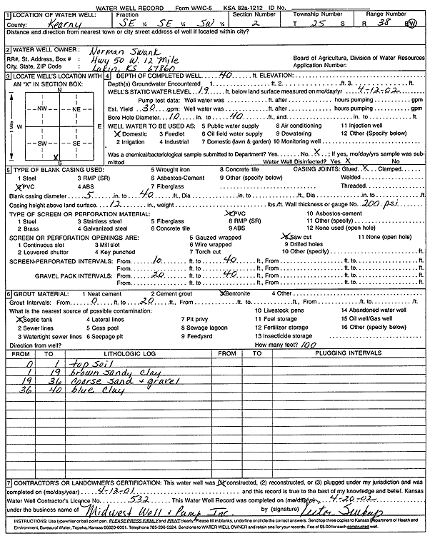
T25S, R38W, Sec. 2 SE SE SW |
Swank, Norman | 40 ft. | 19 ft. | 30 gpm. | Domestic | Constructed | 12-Apr-2001 | Scan | |
|
T25S, R38W, Sec. 7 C |
Berlier, Earl | 135 ft. | 42 ft. | Domestic | Constructed | 23-May-1984 | |||
|
T25S, R38W, Sec. 11 NE NE SE |
Kansas Geological Survey | 33 ft. | 6.9 ft. | Monitoring well/observation/piezometer | Tate Observation Well 2 | Constructed | 02-Aug-2000 | ||
|
T25S, R38W, Sec. 11 SE NE NE |
Kansas Geological Survey | 30 ft. | 3 ft. | Monitoring well/observation/piezometer | Tate Observation Well 1 | Constructed | 02-Aug-2000 | ||
|
T25S, R38W, Sec. 11 S2 SE SE |
Triple T Farms | 60 ft. | 47 ft. | Domestic | Plugged | 10-Apr-1993 | |||
|
T25S, R38W, Sec. 12 NE |
Kash, Clarence | 39 ft. | 16 ft. | Domestic | Constructed | 11-Aug-1981 | |||
|
T25S, R38W, Sec. 12 NW SW NE |
Kash, Clarence | 22 ft. | 5 ft. | Irrigation | 97-49 | Plugged | 16-May-1997 | ||
|
T25S, R38W, Sec. 12 NW SW NE |
Kash, Clarence | 22 ft. | 5 ft. | Irrigation | 97-13 | Plugged | 16-May-1997 | ||
|
T25S, R38W, Sec. 13 SW NW SW |
Berlier, Wade | 160 ft. | 52 ft. | Domestic | Constructed | 09-Dec-1996 | |||
|
T25S, R38W, Sec. 16 C SE |
Amoco Production | 160 ft. | 40 ft. | 100 gpm. | Oil Field Water Supply | 3 H 1 Cohen Max GU | Constructed | 12-Dec-1993 | |
|
T25S, R38W, Sec. 16 SE NW |
Berlier, Earl | 110 ft. | 62 ft. | Domestic | Constructed | 26-May-1984 | |||
|
T25S, R38W, Sec. 23 NE NE SW |
Triple T Farms | 45 ft. | Domestic | Plugged | 10-Apr-1993 | Scan | |||
|
T25S, R38W, Sec. 23 C SW |
Triple T Farms | 140 ft. | 44 ft. | Domestic | Constructed | 16-Jun-1994 | |||
|
T25S, R38W, Sec. 24 NW NW SE |
Triple T Farms | 46 ft. | Domestic | Plugged | 09-Apr-1993 | ||||
|
T25S, R38W, Sec. 26 SE NE SW |
P 5 Ranch | 243 ft. | 72 ft. | 45 gpm. | Domestic, Livestock | Constructed | 31-Aug-2023 |
KOLAR |
|
|
T25S, R38W, Sec. 27 SE SE NE |
Amoco Production | 155 ft. | 53 ft. | 55 gpm. | Oil Field Water Supply | Constructed | 19-Nov-1983 | ||
|
T25S, R38W, Sec. 30 NE SE SW |
Klaason, Herb | 250 ft. | 90 ft. | Domestic | Constructed | 22-Mar-1981 | |||
|
T25S, R38W, Sec. 31 NE SE NE |
Rider, Nelson | 106 ft. | 65 ft. | Domestic | Plugged | 18-Aug-1996 | |||
|
T25S, R38W, Sec. 32 SW SW SW |
Baker, Lyle | 440 ft. | 119 ft. | 25 gpm. | Domestic | Constructed | 06-Apr-1979 | ||
|
T25S, R38W, Sec. 35 NW NW NW |
Murfin Drilling | 160 ft. | 75 ft. | 50 gpm. | Oil Field Water Supply | Constructed | 15-Oct-1985 | ||
|
T25S, R38W, Sec. 35 SE SE NE |
Tate Ranch | 240 ft. | 87 ft. | 10 gpm. | Domestic | Reconstructed | 10-Apr-1993 | ||
|
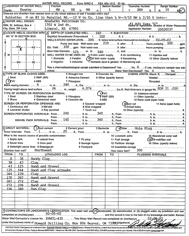
T26S, R35W, Sec. 1 NW SE NW |
Anadarko Petroleum Corp. | 340 ft. | 200 ft. | 100 gpm. | Oil Field Water Supply | HJV Tate C 1 | Constructed | 05-Feb-2002 | Scan |
|
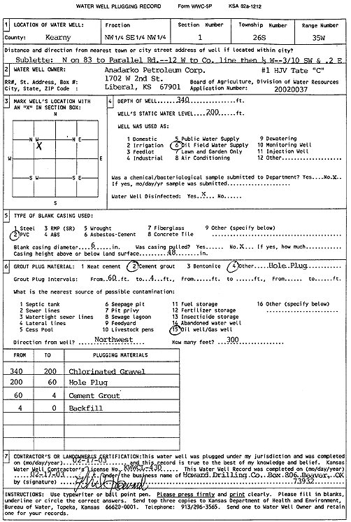
T26S, R35W, Sec. 1 NW SE NW |
Anadarko Petroleum Corp. | 340 ft. | 200 ft. | Oil Field Water Supply | HJV Tate C-1 | Plugged | 17-Feb-2003 | Scan | |
|
T26S, R35W, Sec. 1 NE SW SE |
Triple T Farms | 337 ft. | 176 ft. | 50 gpm. | Domestic, Livestock | Constructed | 28-Aug-1988 | ||
|
T26S, R35W, Sec. 2 SW SE NW |
Bock, Mitchell | 440 ft. | 222 ft. | Irrigation | Well 34 | Constructed | 30-Apr-2002 | Scan | |
|
T26S, R35W, Sec. 2 NE NW |
Bock, Mitchell H and Laurie L | 515 ft. | 166 ft. | Irrigation | Constructed | 15-May-1993 | |||
|
T26S, R35W, Sec. 2 SE NW SW |
Campbell, Jack | 336 ft. | 97 ft. | 1250 gpm. | Irrigation | Constructed | 10-Jun-1977 | ||
|
T26S, R35W, Sec. 2 NW SE NW |
Campbell, Jack | 364 ft. | 110 ft. | 1300 gpm. | Irrigation | Constructed | 10-Jun-1977 | ||
|
T26S, R35W, Sec. 2 SW SE SW |
Campbell, Maxine | 255 ft. | 100 ft. | Domestic, Livestock | Constructed | 02-Jul-1981 | |||
|
T26S, R35W, Sec. 2 N2 NW |
EOG Resources Inc | 320 ft. | Oil Field Water Supply | Beck 2 1 | Plugged | 08-Sep-2010 | |||
|
T26S, R35W, Sec. 2 C N2 NW |
EOG Resources Inc | 320 ft. | 238 ft. | 90 gpm. | Oil Field Water Supply | Constructed | 23-Mar-2010 | ||
|
T26S, R35W, Sec. 2 NE NE NW |
Kood TV | 278 ft. | 140 ft. | 25 gpm. | Domestic | Constructed | 01-Feb-1988 | ||
|
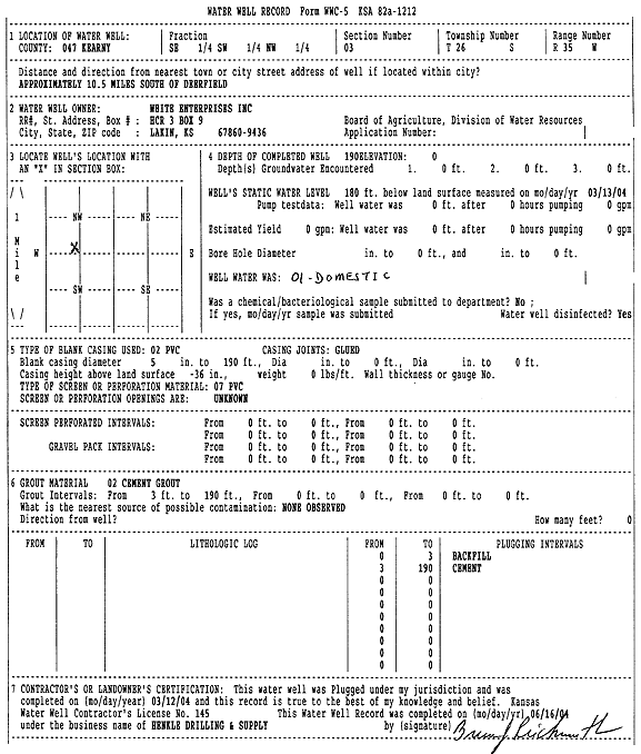
T26S, R35W, Sec. 3 SE SW NW |
White Enterprises, Inc. | 190 ft. | 180 ft. | Domestic | Plugged | 12-Mar-2004 | Scan | ||
|
T26S, R35W, Sec. 3 SE SW NW |
White Enterprises, Inc. | 412 ft. | 197 ft. | Domestic | Constructed | 25-Feb-2004 | Scan | ||
|
T26S, R35W, Sec. 3 SE NW SW |
White, Jim | 366 ft. | 94 ft. | 1900 gpm. | Irrigation | Constructed | 10-Jun-1977 | ||
|
T26S, R35W, Sec. 4 NE NE |
White Enterprises | 400 ft. | 100 ft. | 1560 gpm. | Irrigation | Constructed | 21-May-1982 | ||
|
T26S, R35W, Sec. 4 NE NW |
White Enterprises | 423 ft. | 75 ft. | 1200 gpm. | Irrigation | Constructed | 31-Jan-1975 | ||
|
T26S, R35W, Sec. 4 SE NE NE |
White Enterprises | 529 ft. | 116 ft. | 1750 gpm. | Irrigation | Constructed | 04-Apr-1985 | ||
|
T26S, R35W, Sec. 4 NE NE |
White Enterprises | 398 ft. | 73 ft. | 1200 gpm. | Irrigation | Constructed | 31-Jan-1975 | ||
|
T26S, R35W, Sec. 4 NE NE |
White Enterprises | 398 ft. | 73 ft. | Irrigation | Plugged | 01-Apr-1982 | |||
|
T26S, R35W, Sec. 4 NE SW |
White Enterprises | 400 ft. | 66 ft. | 1300 gpm. | Irrigation | Constructed | 31-Jan-1975 | ||
|
T26S, R35W, Sec. 4 NE SE |
White Enterprises | 300 ft. | 79 ft. | 1200 gpm. | Irrigation | Constructed | 31-Jan-1975 | ||
|
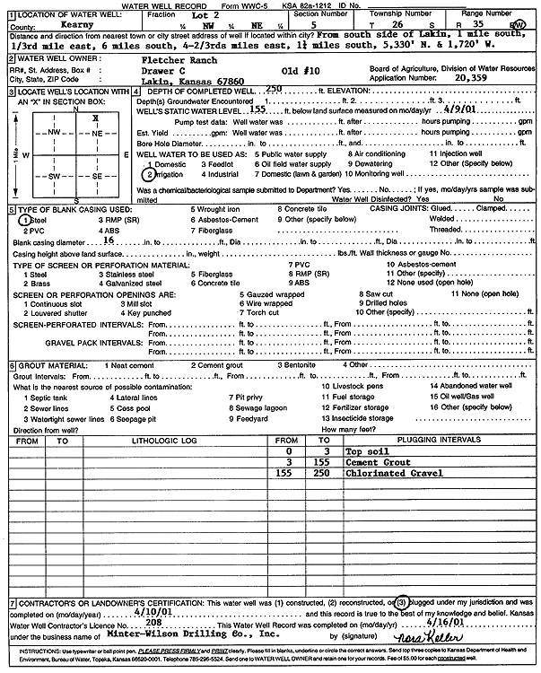
T26S, R35W, Sec. 5 NW NE |
Fletcher Ranch | 250 ft. | 155 ft. | Irrigation | Old 10 | Plugged | 10-Apr-2001 | Scan | |
|
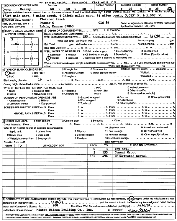
T26S, R35W, Sec. 5 NW NW NW |
Fletcher Ranch | 494 ft. | 155 ft. | Irrigation | Old 9 | Plugged | 10-Apr-2001 | Scan | |
|
T26S, R35W, Sec. 5 NW |
Fletcher Ranch | 435 ft. | 159.5 ft. | Irrigation | Well 9 | Constructed | 30-Mar-2001 | Scan | |
|
T26S, R35W, Sec. 5 NW NE |
Fletcher Ranch | 460 ft. | 125 ft. | Irrigation | Constructed | 22-Apr-1992 | |||
| View page: < Prev || 31 || 32 || 33 || 34 || 35 || 36 || 37 || 38 || 39 || 40 || Next > | |||||||||