Select location of well to view details.
Click on column heading to sort.
|
|
|
County: Kearny Select location of well to view details. Click on column heading to sort. |
|
|
|
| View page: < Prev || 31 || 32 || 33 || 34 || 35 || 36 || 37 || 38 || 39 || 40 || Next > | |||||||||
| T-R-S | Owner | Well Depth Ascend. Desc. |
Static Water Level Ascend. Desc. |
Est. Yield Ascend. Desc. |
Well Use | Other ID | Action Taken | Completion Date Ascend. Desc. |
Scan? |
|
T26S, R35W, Sec. 5 SE NE NW |
Fletcher Ranch, Inc, | 430 ft. | 178 ft. | Irrigation | Constructed | 08-Jan-2003 | Scan | ||
|
T26S, R35W, Sec. 5 W2 NW NW |
Fletcher, Walter | 550 ft. | 90 ft. | Irrigation | Constructed | 01-May-1983 | |||
|
T26S, R35W, Sec. 5 SE |
Fletcher, Walter | 340 ft. | 184 ft. | 1500 gpm. | Irrigation | Constructed | 28-Mar-1979 | ||
|
T26S, R35W, Sec. 5 NE NE SW |
Walter Fletcher Ranch/Sweetman Drlg/McCoy Petro. | 280 ft. | 146 ft. | 100 gpm. | Oil Field Water Supply | Fletcher 1-5 | Constructed | 18-Mar-1989 | |
|
T26S, R35W, Sec. 6 NE SW SW |
Cheyenne Drilling | 280 ft. | 120 ft. | 100 gpm. | Oil Field Water Supply | Masonic Home 2-1 | Constructed | 25-May-1993 | |
|
T26S, R35W, Sec. 6 SW NE |
Fletcher Ranch | 420 ft. | 186 ft. | Irrigation | Well 8 | Constructed | 31-Oct-2003 | Scan | |
|
T26S, R35W, Sec. 7 NE |
Fletcher, Walter | 275 ft. | 92 ft. | 1650 gpm. | Irrigation | Constructed | 31-Dec-1981 | ||
|
T26S, R35W, Sec. 7 SE |
Fletcher, Walter | 285 ft. | 86 ft. | 1500 gpm. | Irrigation | Constructed | 30-Dec-1981 | ||
|
T26S, R35W, Sec. 7 NE SW SW |
H-30 Drilling, Inc. | 200 ft. | 70 ft. | 65 gpm. | Oil Field Water Supply | 7-I Tate | Constructed | 21-Feb-1989 | |
|
T26S, R35W, Sec. 7 NE SW SW |
H-30 Drilling, Inc. | 200 ft. | 70 ft. | 65 gpm. | Oil Field Water Supply | 7 I Tate | Plugged | 29-May-1989 | |
|
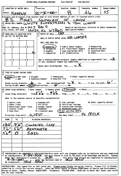
T26S, R35W, Sec. 8 SE SE NE |
White Enterprises | 130 ft. | Domestic | Plugged | 04-Apr-2001 | Scan | |||
|
T26S, R35W, Sec. 8 SE SE SE |
White Enterprises/Mobil Oil Corp. | 320 ft. | 132 ft. | 100 gpm. | Oil Field Water Supply | Constructed | 07-May-1986 | ||
|
T26S, R35W, Sec. 10 C NW |
Hitch Family Farms | 522 ft. | 135 ft. | 1600 gpm. | Irrigation | Constructed | 09-Jul-1980 | ||
|
T26S, R35W, Sec. 10 C NE |
Hitch Family Farms | 480 ft. | 140 ft. | 1500 gpm. | Irrigation | Constructed | 17-Dec-1980 | ||
|
T26S, R35W, Sec. 10 C SE |
Hitch Family Farms | 485 ft. | 130 ft. | 1400 gpm. | Irrigation | Constructed | 05-Dec-1980 | ||
|
T26S, R35W, Sec. 10 NE NE NW |
Koehn, Jeff | 260 ft. | 130 ft. | Domestic | Constructed | 06-Apr-1990 | |||
|
T26S, R35W, Sec. 11 C SE |
Hitch Family Farms | 625 ft. | 153 ft. | 1930 gpm. | Irrigation | Constructed | 09-Dec-1980 | ||
|
T26S, R35W, Sec. 11 C SW |
Hitch Family Farms | 490 ft. | 135 ft. | 1700 gpm. | Irrigation | Constructed | 30-Jul-1980 | ||
|
T26S, R35W, Sec. 11 C SW |
Ridgeview Farms | 491 ft. | 312 ft. | Irrigation | Constructed | 21-Jul-2006 | |||
|
T26S, R35W, Sec. 11 SW NW NW |
White Enterprises | 330 ft. | 195 ft. | Domestic | Constructed | 25-Jun-1999 | Scan | ||
|
T26S, R35W, Sec. 11 NW NE NE |
White, Harold | 367 ft. | 138 ft. | 100 gpm. | Oil Field Water Supply | Harold White 1 | Constructed | 22-Aug-1985 | |
|
T26S, R35W, Sec. 12 SW SE SE |
White, Harold | 324 ft. | 100 ft. | 1150 gpm. | Irrigation | Constructed | 30-May-1976 | ||
|
T26S, R35W, Sec. 12 NE SW NE |
White, Harold | 352 ft. | 81 ft. | 1100 gpm. | Irrigation | Constructed | 29-Feb-1976 | ||
|
T26S, R35W, Sec. 13 SE NW NE |
CEB Inc. | 411 ft. | 261 ft. | Irrigation | Plugged | 09-Nov-2017 | |||
|
T26S, R35W, Sec. 13 C SE |
Hitch Family Farms | 440 ft. | 151 ft. | 1800 gpm. | Irrigation | Constructed | 23-Jul-1980 | ||
|
T26S, R35W, Sec. 13 C SW |
Hitch Family Farms | 420 ft. | 124 ft. | 1600 gpm. | Irrigation | Constructed | 18-Jun-1980 | ||
|
T26S, R35W, Sec. 13 NE SW NE |
White, Harold | 320 ft. | 111 ft. | 1275 gpm. | Irrigation | Constructed | 29-Feb-1976 | ||
|
T26S, R35W, Sec. 14 SW SE NE |
Cheyenne Drilling | 320 ft. | 145 ft. | 100 gpm. | Oil Field Water Supply | 1 Flint Hills | Constructed | 29-Mar-1992 | |
|
T26S, R35W, Sec. 14 C SE |
Hitch Family Farms | 615 ft. | 176 ft. | 1225 gpm. | Irrigation | Constructed | 21-Jul-1980 | ||
|
T26S, R35W, Sec. 14 C NW |
Hitch Family Farms | 595 ft. | 159 ft. | 1550 gpm. | Irrigation | Constructed | 01-Aug-1980 | ||
|
T26S, R35W, Sec. 14 C NE |
Hitch Family Farms | 597 ft. | 159 ft. | 2000 gpm. | Irrigation | Constructed | 04-Dec-1980 | ||
|
T26S, R35W, Sec. 14 C SW |
Hitch Family Farms | 568 ft. | 146 ft. | 1300 gpm. | Irrigation | Constructed | 25-Jul-1980 | ||
|
T26S, R35W, Sec. 14 C NE SE |
Sage Drilling Company | 240 ft. | 122 ft. | 50 gpm. | Oil Field Water Supply | Rig 5 | Constructed | 28-Mar-1975 | |
|
T26S, R35W, Sec. 15 C SE |
Hitch Family Farms | 450 ft. | 101 ft. | 2000 gpm. | Irrigation | Constructed | 09-Apr-1980 | ||
|
T26S, R35W, Sec. 15 C NW |
Hitch Family Farms | 545 ft. | 130 ft. | 1870 gpm. | Irrigation | Constructed | 05-Jul-1980 | ||
|
T26S, R35W, Sec. 15 C SW |
Hitch Family Farms | 395 ft. | 127 ft. | 1000 gpm. | Irrigation | Constructed | 17-Dec-1980 | ||
|
T26S, R35W, Sec. 15 C NE |
Hitch Family Farms | 485 ft. | 125 ft. | 2500 gpm. | Irrigation | Constructed | 10-Dec-1980 | ||
|
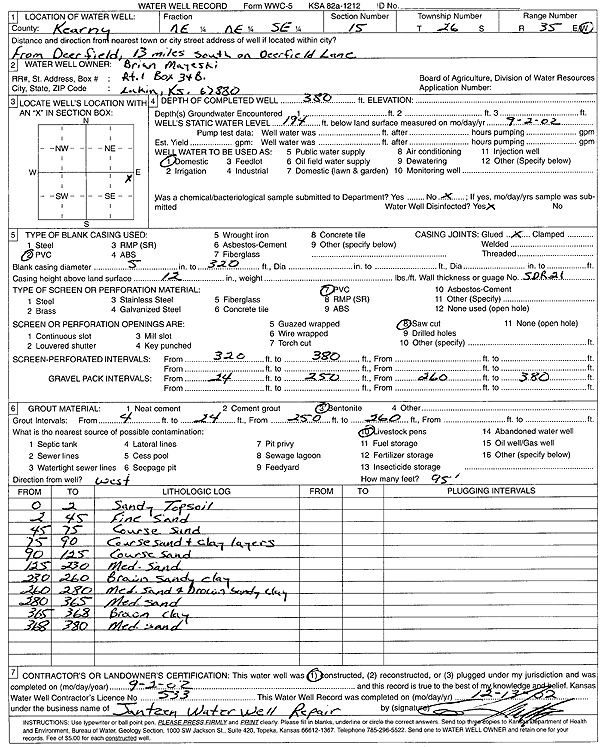
T26S, R35W, Sec. 15 NE NE SE |
Mayeski, Brian | 380 ft. | 194 ft. | Domestic | Constructed | 02-Sep-2002 | Scan | ||
|
T26S, R35W, Sec. 15 NE NE SE |
Wedel, Simon | 320 ft. | 160 ft. | 16 gpm. | Domestic | Constructed | 14-Apr-1994 | ||
|
T26S, R35W, Sec. 16 C NW SW |
Sweetman/McCoy Petroleum | 280 ft. | 100 gpm. | Oil Field Water Supply | White 1-16 | Constructed | 27-Mar-1989 | ||
|
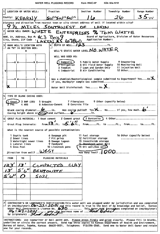
T26S, R35W, Sec. 16 SW SW SW |
White Enterprises | 123 ft. | Domestic | Plugged | 22-Jun-2001 | Scan | |||
|
T26S, R35W, Sec. 16 C SE SW |
White, James | 300 ft. | 127 ft. | 100 gpm. | Oil Field Water Supply | Dunn White Fee 1 | Constructed | 09-Feb-1985 | |
|
T26S, R35W, Sec. 18 NE |
Fletcher, Walter | 285 ft. | 77 ft. | 1400 gpm. | Irrigation | Constructed | 29-Feb-1980 | ||
|
T26S, R35W, Sec. 18 NE NW SW |
H-30 Drilling, Inc. | 220 ft. | 100 ft. | 70 gpm. | Oil Field Water Supply | 6-I Tate | Constructed | 08-Feb-1989 | |
|
T26S, R35W, Sec. 18 NE NW SW |
H-30 Drilling, Inc. | 220 ft. | 100 ft. | 70 gpm. | Oil Field Water Supply | 6-1 | Plugged | 29-May-1989 | |
|
T26S, R35W, Sec. 19 SW |
Fletcher, Walter | 357 ft. | 99 ft. | 1500 gpm. | Irrigation | Constructed | 28-Mar-1979 | ||
|
T26S, R35W, Sec. 19 SE |
Fletcher, Walter | 306 ft. | 90 ft. | 1500 gpm. | Irrigation | Constructed | 28-Mar-1979 | ||
|
T26S, R35W, Sec. 19 SW SW NE |
Sweetman Drilling, Inc | 302 ft. | 128 ft. | 100 gpm. | Oil Field Water Supply | Constructed | 26-May-1988 | ||
|
T26S, R35W, Sec. 20 NE NW SE |
Fletcher, Walter | 309 ft. | 118 ft. | 1200 gpm. | Irrigation | Constructed | 28-Mar-1979 | ||
|
T26S, R35W, Sec. 20 SW |
Fletcher, Walter | 331 ft. | 118 ft. | 1500 gpm. | Irrigation | Constructed | 28-Mar-1979 | ||
| View page: < Prev || 31 || 32 || 33 || 34 || 35 || 36 || 37 || 38 || 39 || 40 || Next > | |||||||||