Select location of well to view details.
Click on column heading to sort.
|
|
|
County: Labette Select location of well to view details. Click on column heading to sort. |
|
|
|
| View page: 1 || 2 || 3 || 4 || 5 || 6 || 7 || 8 || 9 || 10 || Next > | |||||||||
| T-R-S | Owner | Well Depth Ascend. Desc. |
Static Water Level Ascend. Desc. |
Est. Yield Ascend. Desc. |
Well Use | Other ID | Action Taken | Completion Date Ascend. Desc. |
Scan? |
|
T31S, R19E, Sec. 24 NW NW NW NE |
KDHE | 8.62 ft. | Monitoring well/observation/piezometer | MW 5 | Plugged | 24-Mar-2016 | |||
|
T31S, R19E, Sec. 24 NE NE NW |
KDHE | 10 ft. | Monitoring well/observation/piezometer | MW 7 | Constructed | 05-Jun-2014 | |||
|
T31S, R19E, Sec. 24 NW NW NE |
KDHE | 8.9 ft. | 4.5 ft. | Monitoring well/observation/piezometer | MW 5 | Constructed | 06-Jun-2014 | ||
|
T31S, R19E, Sec. 24 NW NW NW |
Stover Oil Co, Inc. | 15.5 ft. | Monitoring well/observation/piezometer | MW 7 | Plugged | 15-May-2013 | |||
|
T31S, R19E, Sec. 24 NW NW NW |
Stover Oil Co, Inc. | 14.85 ft. | Monitoring well/observation/piezometer | MW 2 | Plugged | 13-May-2013 | |||
|
T31S, R19E, Sec. 24 NW NW NW |
Stover Oil Co, Inc. | 16.8 ft. | Monitoring well/observation/piezometer | MW 5 | Plugged | 25-Mar-2013 | |||
|
T31S, R19E, Sec. 24 NW NW NW |
Stover Oil Co, Inc. | 16.8 ft. | Monitoring well/observation/piezometer | MW 1 | Plugged | 25-Mar-2013 | |||
|
T31S, R19E, Sec. 24 NW NW NW |
Stover Oil Co, Inc. | 19.3 ft. | Monitoring well/observation/piezometer | MW 3 | Plugged | 25-Mar-2013 | |||
|
T31S, R19E, Sec. 24 NW NW NW |
Stover Oil Co. Inc | 16 ft. | 12.61 ft. | Monitoring well/observation/piezometer | MW 1 | Constructed | 27-Sep-2010 | ||
|
T31S, R19E, Sec. 24 NW NW NW |
Stover Oil Co. Inc | 15 ft. | 5.22 ft. | Monitoring well/observation/piezometer | MW 2 | Constructed | 27-Sep-2010 | ||
|
T31S, R19E, Sec. 24 NW NW NW |
Stover Oil Co. Inc | 15 ft. | 12.17 ft. | Monitoring well/observation/piezometer | MW 5 | Constructed | 28-Sep-2010 | ||
|
T31S, R19E, Sec. 24 NW NW NW |
Stover Oil Co. Inc | 15 ft. | 12.53 ft. | Monitoring well/observation/piezometer | MW 7 | Constructed | 28-Sep-2010 | ||
|
T31S, R19E, Sec. 24 NW NW NW |
Stover Oil Co. Inc | 15 ft. | 14.08 ft. | Monitoring well/observation/piezometer | MW 3 | Constructed | 27-Sep-2010 | ||
|
T31S, R19E, Sec. 24 SW SW NW |
Technacarbon | 11 ft. | 6 ft. | Monitoring well/observation/piezometer | Constructed | 12-Jan-1993 | |||
|
T31S, R19E, Sec. 24 SW SW NW |
Technacarbon | 7 ft. | 2 ft. | Monitoring well/observation/piezometer | Constructed | 12-Jan-1993 | |||
|
T31S, R19E, Sec. 24 SW SW NW |
Technacarbon | 7 ft. | 2 ft. | Monitoring well/observation/piezometer | Constructed | 12-Jan-1993 | |||
|
T31S, R19E, Sec. 30 NW NW NW |
Hambleton, Rodney L. | 60 ft. | Test hole/well | Plugged | 10-May-1990 | ||||
|
T31S, R19E, Sec. 30 NW NW NW |
Hambleton, Rodney L. | 98 ft. | 12 ft. | 1.25 gpm. | Domestic | Constructed | 15-May-1990 | ||
|
T31S, R19E, Sec. 36 NE NE SW |
Hummer, Emmett Dean | 37.5 ft. | Monitoring well/observation/piezometer | Constructed | 21-May-2008 | ||||
|
T31S, R19E, Sec. 36 NW SW NE |
Labette County Landfill, Inc. | 27.5 ft. | 10.35 ft. | Monitoring well/observation/piezometer | Well 7 | Constructed | 23-Nov-2005 | ||
|
T31S, R19E, Sec. 36 SW SW NE |
Labette County Landfill, Inc. | 27.5 ft. | 1.77 ft. | Monitoring well/observation/piezometer | Well 9 | Constructed | 23-Nov-2005 | ||
|
T31S, R19E, Sec. 36 NW SW NE |
Labette County Landfill, Inc. | 27.5 ft. | 3.7 ft. | Monitoring well/observation/piezometer | Well 8 | Constructed | 23-Nov-2005 | ||
|
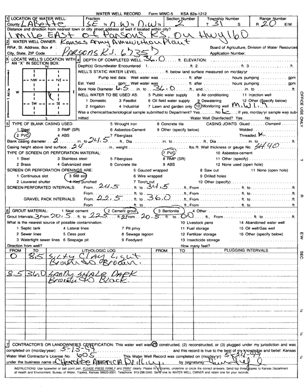
T31S, R20E, Sec. 2 SE NW NW |
Kansas Army Ammunition Plant | 36 ft. | Monitoring well/observation/piezometer | MW 1-7 | Constructed | 13-May-1999 | Scan | ||
|
T31S, R20E, Sec. 2 NW NW NE |
Kansas Army Ammunition Plant | 16.7 ft. | Monitoring well/observation/piezometer | MW 17-5 | Constructed | 01-May-1996 | |||
|
T31S, R20E, Sec. 2 SE NW NW |
Kansas Army Ammunition Plant | 35 ft. | Monitoring well/observation/piezometer | MW 19-5 | Constructed | 20-May-1996 | |||
|
T31S, R20E, Sec. 2 SE NW NW |
Kansas Army Ammunition Plant | 23 ft. | Monitoring well/observation/piezometer | MW 2-7 | Constructed | 14-May-1999 | |||
|
T31S, R20E, Sec. 2 SE NW NW |
Kansas Army Ammunition Plant | 16 ft. | Monitoring well/observation/piezometer | MW 21-5 | Constructed | 17-May-1996 | |||
|
T31S, R20E, Sec. 2 SE NW NW |
Kansas Army Ammunition Plant | 32.5 ft. | Monitoring well/observation/piezometer | MW 20-5 | Constructed | 18-May-1996 | |||
|
T31S, R20E, Sec. 2 NW NW NE |
Kansas Army Ammunition Plant | 16.5 ft. | Monitoring well/observation/piezometer | MW 16-5 | Constructed | 04-May-1996 | |||
|
T31S, R20E, Sec. 2 NW NW NE |
Kansas Army Ammunition Plant | 17 ft. | Monitoring well/observation/piezometer | MW 18-5 | Constructed | 13-May-1996 | |||
|
T31S, R20E, Sec. 8 NW NW SE |
Former Casey's 1362 | 12 ft. | Monitoring well/observation/piezometer | MW 6 | Constructed | 31-May-2007 | |||
|
T31S, R20E, Sec. 10 SE NW SE |
Kansas Army Ammunition Plant | 25 ft. | Monitoring well/observation/piezometer | MW 1-17 | Constructed | 10-Apr-2012 | |||
|
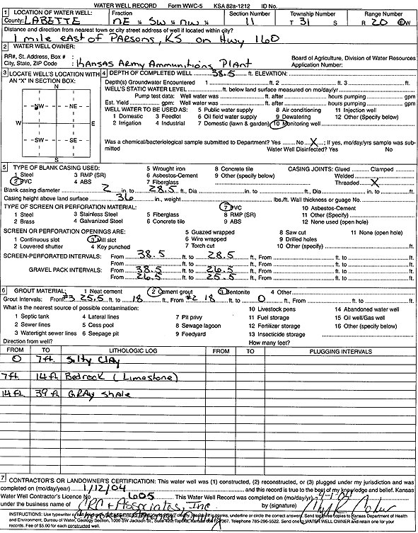
T31S, R20E, Sec. 11 NE SW NW |
Kansas Army Ammunition Plant | 38.5 ft. | Monitoring well/observation/piezometer | Constructed | 12-Jan-2004 | Scan | |||
|
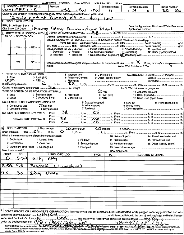
T31S, R20E, Sec. 11 SE SW NW |
Kansas Army Ammunition Plant | 38 ft. | Monitoring well/observation/piezometer | Constructed | 14-Jan-2004 | Scan | |||
|
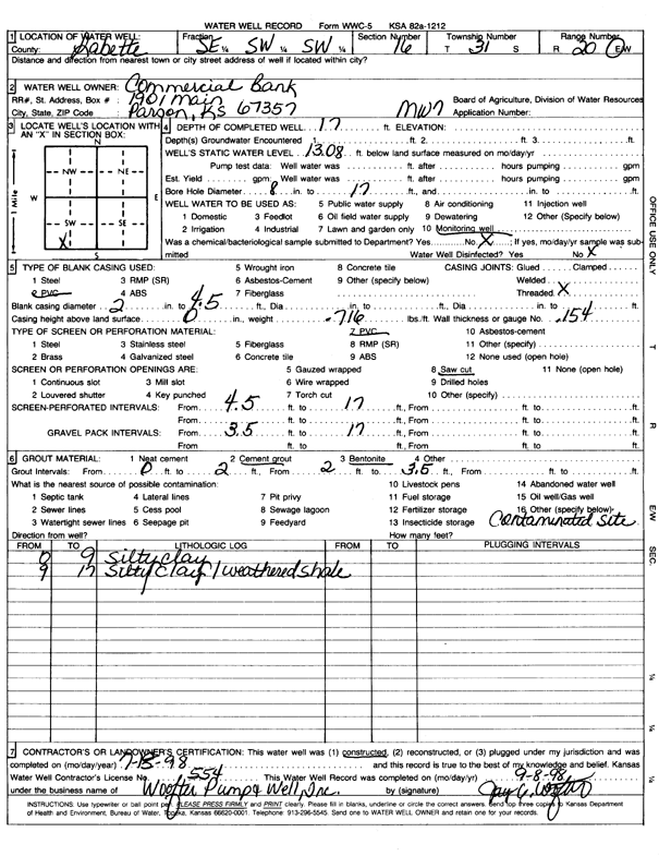
T31S, R20E, Sec. 16 SE SW SW |
Commercial Bank | 19 ft. | 6.4 ft. | Monitoring well/observation/piezometer | MW 10 | Constructed | 27-Jul-2010 | ||
|
T31S, R20E, Sec. 16 SE SW SW |
Commercial Bank | 17 ft. | 13.08 ft. | Monitoring well/observation/piezometer | MW 7 | Constructed | 15-Jul-1998 | Scan | |
|
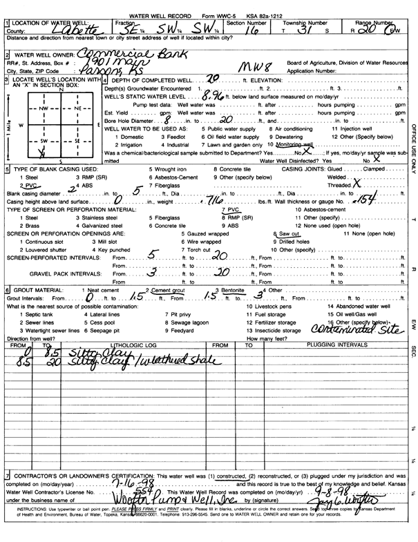
T31S, R20E, Sec. 16 SE SW SW |
Commercial Bank | 20 ft. | 8.96 ft. | Monitoring well/observation/piezometer | MW 8 | Constructed | 16-Jul-1998 | Scan | |
|
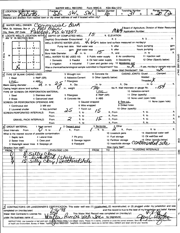
T31S, R20E, Sec. 16 SE SW SW |
Commercial Bank | 15 ft. | 4.66 ft. | Monitoring well/observation/piezometer | MW 4 | Constructed | 16-Jul-1998 | Scan | |
|
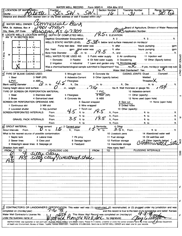
T31S, R20E, Sec. 16 SE SW SW |
Commercial Bank | 19.5 ft. | 5.38 ft. | Monitoring well/observation/piezometer | MW 5 | Constructed | 16-Jul-1998 | Scan | |
|
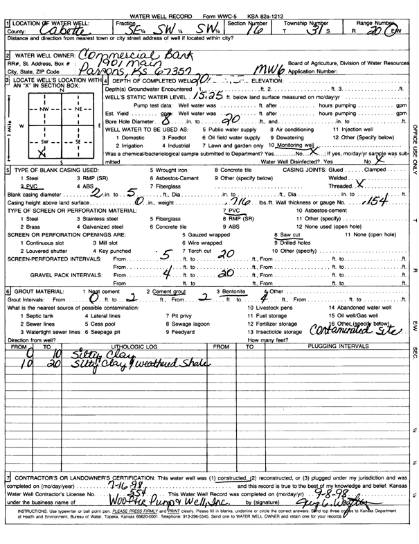
T31S, R20E, Sec. 16 SE SW SW |
Commercial Bank | 20 ft. | 15.25 ft. | Monitoring well/observation/piezometer | MW 6 | Constructed | 16-Jul-1998 | Scan | |
|
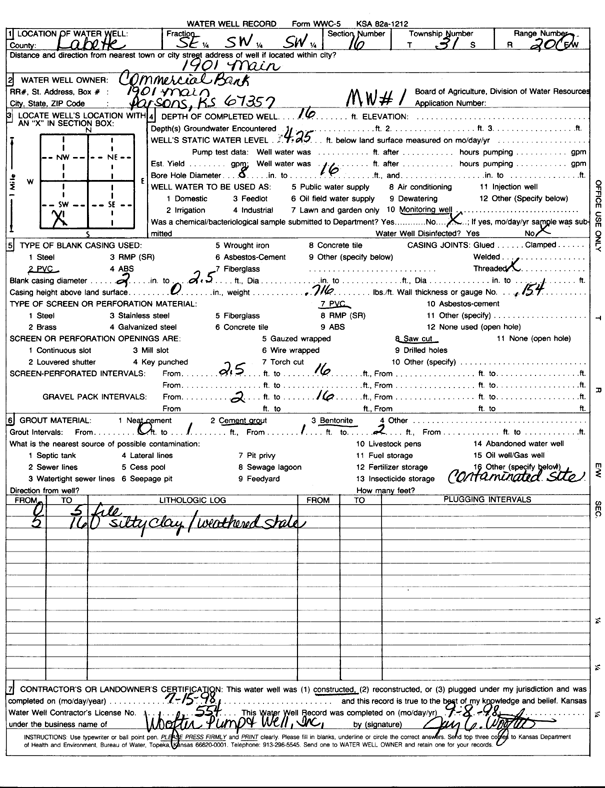
T31S, R20E, Sec. 16 SE SW SW |
Commercial Bank | 16 ft. | 4.25 ft. | Monitoring well/observation/piezometer | MW 1 | Constructed | 15-Jul-1998 | Scan | |
|
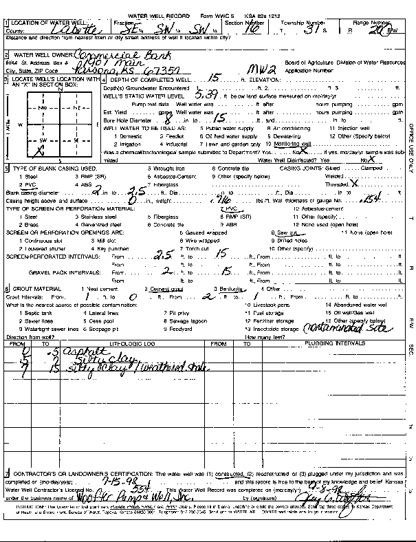
T31S, R20E, Sec. 16 SE SW SW |
Commercial Bank | 15 ft. | 5.39 ft. | Monitoring well/observation/piezometer | MW 2 | Constructed | 15-Jul-1998 | Scan | |
|
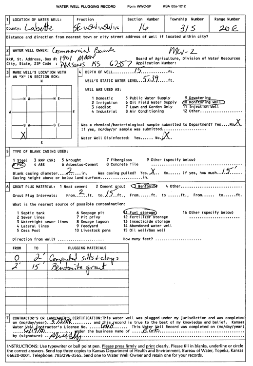
T31S, R20E, Sec. 16 SE SW SW |
Commercial Bank | 15 ft. | 5.39 ft. | Monitoring well/observation/piezometer | MW 2 | Plugged | 03-May-2000 | Scan | |
|
T31S, R20E, Sec. 16 SE SW SW |
Commercial Bank | 17 ft. | 13.08 ft. | Monitoring well/observation/piezometer | MW 7 | Plugged | 03-May-2000 | ||
|
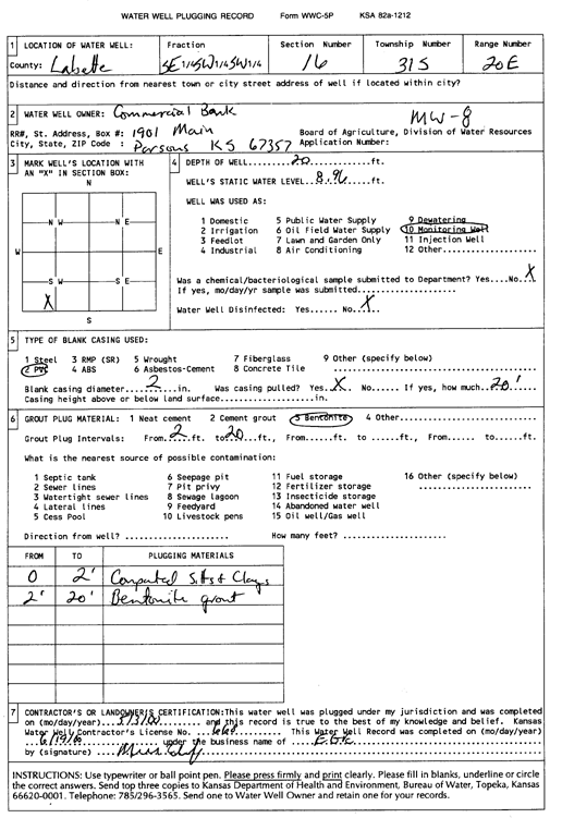
T31S, R20E, Sec. 16 SE SW SW |
Commercial Bank | 20 ft. | 8.96 ft. | Monitoring well/observation/piezometer | MW 8 | Plugged | 03-May-2000 | Scan | |
|
T31S, R20E, Sec. 16 SE SW SW |
Commercial Bank | 18 ft. | Monitoring well/observation/piezometer | MW 9 | Constructed | 30-Oct-2007 | |||
|
T31S, R20E, Sec. 16 SE SW SW |
Commercial Bank | 18.5 ft. | Monitoring well/observation/piezometer | MW 3 | Plugged | 11-Jan-2011 | |||
|
T31S, R20E, Sec. 16 SE SW SW |
Commercial Bank | 14.4 ft. | Monitoring well/observation/piezometer | MW 4 | Plugged | 11-Jan-2011 | |||
|
T31S, R20E, Sec. 16 SE SW SW |
Commercial Bank | 14 ft. | Monitoring well/observation/piezometer | MW 1 | Plugged | 11-Jan-2011 | |||
|
T31S, R20E, Sec. 16 SE SW SW |
Commercial Bank | 19 ft. | Monitoring well/observation/piezometer | MW 10 | Plugged | 11-Jan-2011 | |||
| View page: 1 || 2 || 3 || 4 || 5 || 6 || 7 || 8 || 9 || 10 || Next > | |||||||||