Select location of well to view details.
Click on column heading to sort.
|
|
|
County: Labette Select location of well to view details. Click on column heading to sort. |
|
|
|
| View page: 1 || 2 || 3 || 4 || 5 || 6 || 7 || 8 || 9 || 10 || Next > | |||||||||
| T-R-S | Owner | Well Depth Ascend. Desc. |
Static Water Level Ascend. Desc. |
Est. Yield Ascend. Desc. |
Well Use | Other ID | Action Taken | Completion Date Ascend. Desc. |
Scan? |
|
T31S, R20E, Sec. 19 NW NW NE |
Fastrip 4 | 8 ft. | Monitoring well/observation/piezometer | MW 6 | Constructed | 17-Feb-2004 | Scan | ||
|
T31S, R20E, Sec. 19 NW NW NE |
Fastrip 4 | 6.82 ft. | Monitoring well/observation/piezometer | MW 6 | Plugged | 17-Mar-2010 | |||
|
T31S, R20E, Sec. 19 NW NW NE |
Fastrip 4 | 8 ft. | Monitoring well/observation/piezometer | MW 5 | Constructed | 17-Feb-2004 | Scan | ||
|
T31S, R20E, Sec. 19 NW NW NE |
Fastrip 4 | 6 ft. | 5.61 ft. | Monitoring well/observation/piezometer | MW 3 | Constructed | 18-Feb-1997 | ||
|
T31S, R20E, Sec. 19 NW NW NE |
Fastrip 4 | 5 ft. | Monitoring well/observation/piezometer | MW 4 | Constructed | 18-Feb-1997 | |||
|
T31S, R20E, Sec. 19 NW NW NE |
Fastrip 4 | 6 ft. | 4.46 ft. | Monitoring well/observation/piezometer | MW 1 | Constructed | 18-Feb-1997 | ||
|
T31S, R20E, Sec. 19 SW SW NE |
Manners, Dan | 12 ft. | 7.01 ft. | Monitoring well/observation/piezometer | MW 2 | Plugged | 18-Jul-2006 | ||
|
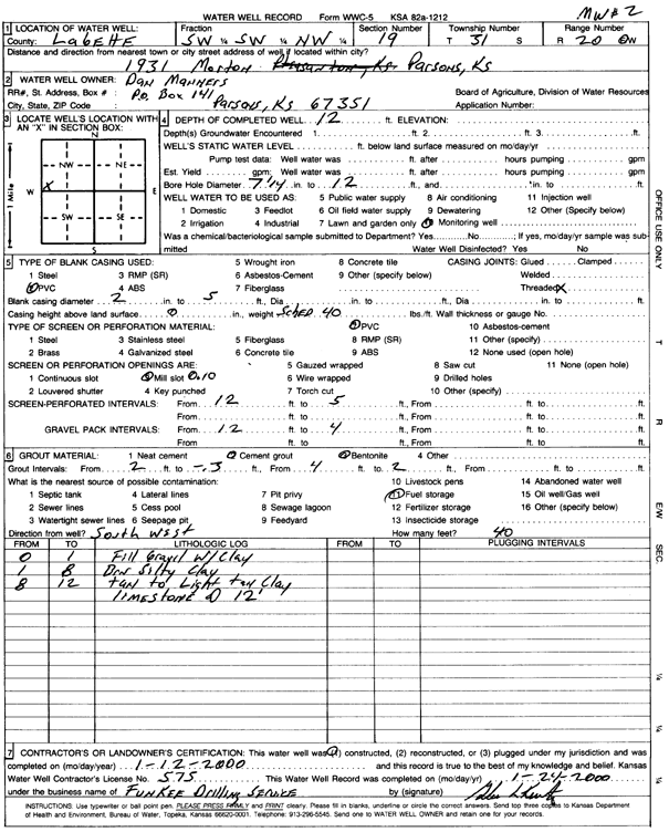
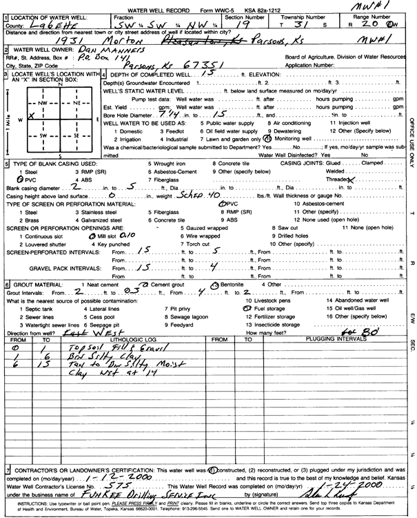
T31S, R20E, Sec. 19 SW SW NW |
Manners, Dan | 12 ft. | Monitoring well/observation/piezometer | MW 2 | Constructed | 12-Jan-2000 | Scan | ||
|
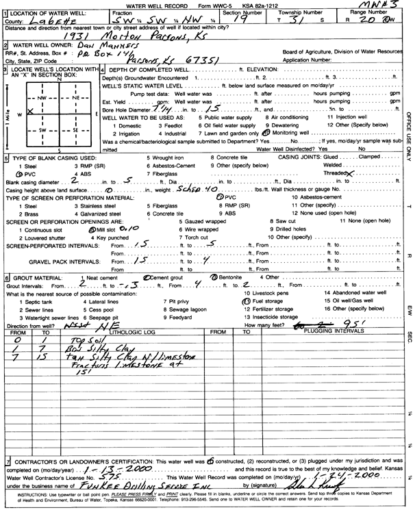
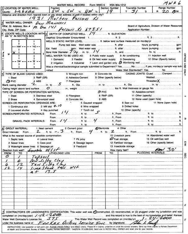
T31S, R20E, Sec. 19 SW SW NW |
Manners, Dan | 15 ft. | Monitoring well/observation/piezometer | MW 3 | Constructed | 13-Jan-2000 | Scan | ||
|
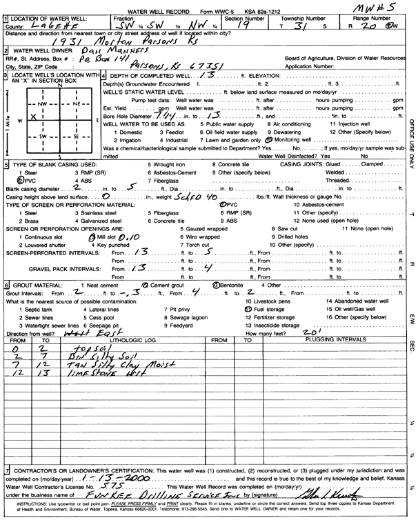
T31S, R20E, Sec. 19 SW SW NW |
Manners, Dan | 13 ft. | Monitoring well/observation/piezometer | MW 5 | Constructed | 13-Jan-2000 | Scan | ||
|
T31S, R20E, Sec. 19 SW SW NE |
Manners, Dan | 14.5 ft. | 7.62 ft. | Monitoring well/observation/piezometer | MW 3 | Plugged | 18-Jul-2006 | ||
|
T31S, R20E, Sec. 19 SW SW NE |
Manners, Dan | 15 ft. | 4.05 ft. | Monitoring well/observation/piezometer | MW 1 | Plugged | 18-Jul-2006 | ||
|
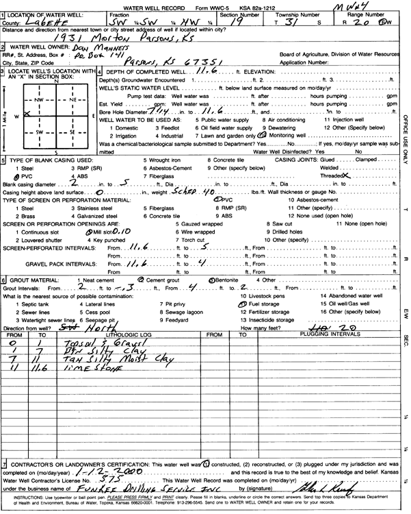
T31S, R20E, Sec. 19 SW SW NW |
Manners, Dan | 11.6 ft. | Monitoring well/observation/piezometer | MW 4 | Constructed | 12-Jan-2000 | Scan | ||
|
T31S, R20E, Sec. 19 SW SW NE |
Manners, Dan | 10.5 ft. | 6.5 ft. | Monitoring well/observation/piezometer | MW 4 | Plugged | 18-Jul-2006 | ||
|
T31S, R20E, Sec. 19 SW SW NE |
Manners, Dan | 10.5 ft. | 2.99 ft. | Monitoring well/observation/piezometer | MW 6 | Plugged | 18-Jul-2006 | ||
|
T31S, R20E, Sec. 19 SW SW NW |
Manners, Dan | 15 ft. | Monitoring well/observation/piezometer | MW 1 | Constructed | 12-Jan-2000 | Scan | ||
|
T31S, R20E, Sec. 19 SW SW NE |
Manners, Dan | 13 ft. | 8.12 ft. | Monitoring well/observation/piezometer | MW 5 | Plugged | 18-Jul-2006 | ||
|
T31S, R20E, Sec. 19 SW SW NW |
Manners, Dan | 14 ft. | Monitoring well/observation/piezometer | MW 6 | Constructed | 12-Jan-2000 | Scan | ||
|
T31S, R20E, Sec. 19 NW NW NE |
Pete's Corporation | 15 ft. | 2.5 ft. | Monitoring well/observation/piezometer | MW 1 | Constructed | 18-Oct-2023 |
KOLAR |
|
|
T31S, R20E, Sec. 19 NW NW NE |
Pete's Corporation | 13.5 ft. | 5.38 ft. | Monitoring well/observation/piezometer | MW 8 | Constructed | 19-Oct-2023 |
KOLAR |
|
|
T31S, R20E, Sec. 19 NW NW NE |
Pete's Corporation | 15 ft. | 6.48 ft. | Monitoring well/observation/piezometer | MW 3 | Constructed | 18-Oct-2023 |
KOLAR |
|
|
T31S, R20E, Sec. 19 NW NW NE |
Pete's Corporation | 14 ft. | 7.45 ft. | Monitoring well/observation/piezometer | MW 2 | Constructed | 17-Oct-2023 |
KOLAR |
|
|
T31S, R20E, Sec. 19 NW NW NE |
Pete's Corporation | 14 ft. | 6.9 ft. | Monitoring well/observation/piezometer | MW 4 | Constructed | 18-Oct-2023 |
KOLAR |
|
|
T31S, R20E, Sec. 19 NW NW NE |
Pete's Corporation | 13.7 ft. | 7.29 ft. | Monitoring well/observation/piezometer | MW 8 | Plugged | 12-Aug-2025 |
KOLAR |
|
|
T31S, R20E, Sec. 19 NW NW NE |
Pete's Corporation | 13.5 ft. | 5.39 ft. | Monitoring well/observation/piezometer | MW 2 | Plugged | 12-Aug-2025 |
KOLAR |
|
|
T31S, R20E, Sec. 19 NW NW NE |
Pete's Corporation | 14.5 ft. | 4.27 ft. | Monitoring well/observation/piezometer | MW 4 | Plugged | 12-Aug-2025 |
KOLAR |
|
|
T31S, R20E, Sec. 19 NW NW NE |
Pete's Corporation | 14.5 ft. | 6.44 ft. | Monitoring well/observation/piezometer | MW 3 | Plugged | 12-Aug-2025 |
KOLAR |
|
|
T31S, R20E, Sec. 19 NW NW NE |
Pete's Corporation | 15 ft. | 3.17 ft. | Monitoring well/observation/piezometer | MW 1 | Plugged | 12-Aug-2025 |
KOLAR |
|
|
T31S, R20E, Sec. 19 NE NE NE SW |
Pete's Corporation | 20 ft. | Monitoring well/observation/piezometer | MW 1 | Constructed | 07-Jan-2015 | |||
|
T31S, R20E, Sec. 19 NE NE NE SW |
Pete's Corporation | 20 ft. | Monitoring well/observation/piezometer | MW 6 | Constructed | 07-Jan-2015 | |||
|
T31S, R20E, Sec. 19 NE NE NE SW |
Pete's Corporation | 20 ft. | Monitoring well/observation/piezometer | MW 4 | Constructed | 07-Jan-2015 | |||
|
T31S, R20E, Sec. 19 NE NE NE SW |
Pete's Corporation | 20 ft. | Monitoring well/observation/piezometer | MW 5 | Constructed | 07-Jan-2015 | |||
|
T31S, R20E, Sec. 19 NE NE NE SW |
Pete's Corporation | 20 ft. | Monitoring well/observation/piezometer | MW 2 | Constructed | 07-Jan-2015 | |||
|
T31S, R20E, Sec. 19 NE NE NE SW |
Pete's Corporation | 20 ft. | Monitoring well/observation/piezometer | MW 3 | Constructed | 06-Jan-2015 | |||
|
T31S, R20E, Sec. 19 NE NW NW |
Pete's of Parsons, Inc | 15 ft. | Monitoring well/observation/piezometer | MW 4 | Constructed | 17-Oct-2007 | |||
|
T31S, R20E, Sec. 19 NE NW NW |
Pete's of Parsons, Inc | 7 ft. | Monitoring well/observation/piezometer | MW 1 | Constructed | 17-Oct-2007 | |||
|
T31S, R20E, Sec. 19 NE NW NW |
Pete's of Parsons, Inc | 15 ft. | Monitoring well/observation/piezometer | MW 2 | Constructed | 17-Oct-2007 | |||
|
T31S, R20E, Sec. 19 NE NW NW |
Pete's of Parsons, Inc | 15 ft. | Monitoring well/observation/piezometer | MW 5 | Constructed | 17-Oct-2007 | |||
|
T31S, R20E, Sec. 19 NE NW NW |
Pete's of Parsons, Inc | 14.55 ft. | 3.65 ft. | Monitoring well/observation/piezometer | MW 2 | Plugged | 11-May-2009 | ||
|
T31S, R20E, Sec. 19 NE NW NW |
Pete's of Parsons, Inc | 14.14 ft. | 4.8 ft. | Monitoring well/observation/piezometer | MW 3 | Plugged | 11-May-2009 | ||
|
T31S, R20E, Sec. 19 NE NW NW |
Pete's of Parsons, Inc | 15 ft. | Monitoring well/observation/piezometer | MW 3 | Constructed | 17-Oct-2007 | |||
|
T31S, R20E, Sec. 19 NE NW NW |
Pete's of Parsons, Inc | 6.69 ft. | 5.47 ft. | Monitoring well/observation/piezometer | MW 1 | Plugged | 11-May-2009 | ||
|
T31S, R20E, Sec. 19 NE NW NW |
Pete's of Parsons, Inc | 12.95 ft. | 4.45 ft. | Monitoring well/observation/piezometer | MW 5 | Plugged | 11-May-2009 | ||
|
T31S, R20E, Sec. 19 NE NW NW |
Pete's of Parsons, Inc | 12.8 ft. | 5.78 ft. | Monitoring well/observation/piezometer | MW 4 | Plugged | 11-May-2009 | ||
|
T31S, R20E, Sec. 21 NE NW NW |
Commercial Bank | 20.5 ft. | Monitoring well/observation/piezometer | MW 6 | Plugged | 11-Jan-2011 | |||
|
T31S, R20E, Sec. 21 NE NW NW |
Commercial Bank | 14 ft. | 8.85 ft. | Monitoring well/observation/piezometer | MW 11 | Constructed | 27-Jul-2010 | ||
|
T31S, R20E, Sec. 21 NE NW NW |
Commercial Bank | 14 ft. | Monitoring well/observation/piezometer | MW 11 | Plugged | 11-Jan-2011 | |||
|
T31S, R20E, Sec. 22 NE NE SW |
Kansas Army Ammunition Plant | 20.91 ft. | 15.08 ft. | Monitoring well/observation/piezometer | BGMW 2 2-6 | Constructed | 13-Jun-1996 | ||
|
T31S, R20E, Sec. 22 NW NE SE |
Kansas Army Ammunition Plant | 22.5 ft. | 9.36 ft. | Monitoring well/observation/piezometer | BGMW 3 3-6 | Constructed | 12-Jun-1996 | ||
|
T31S, R20E, Sec. 22 NW NW SW |
Kansas Army Ammunition Plant | 21.25 ft. | 11.05 ft. | Monitoring well/observation/piezometer | BGMW 1 1-6 | Constructed | 12-Jun-1996 | ||
| View page: 1 || 2 || 3 || 4 || 5 || 6 || 7 || 8 || 9 || 10 || Next > | |||||||||