|
|
|
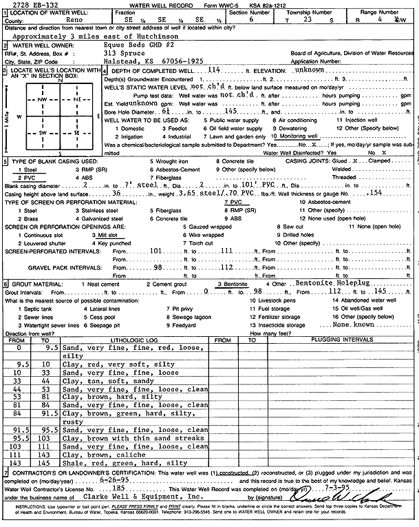
Specific Water Well Detail |
|
|
| Location Info | |||
| Owner: Equus Beds GMD 2 | Status: Constructed | ||
| Location: T23S, R4W, Sec. 6, SE SE SE | County: Reno | ||
| Directions: from Hutchinson: 3 mi E | |||
| Latitude: 38.0729881 | Longitude: -97.7946185 | Datum NAD 27 | |
| Latitude: 38.072999 | Longitude: -97.7949449 | Datum NAD 83 | |
| Longitude and latitude calculated by Survey from township-range-section-quarter calls. Only good to within the quarter call accuracy. | |||
| View well on interactive map | |||
| General Info | ||
| Well Depth: 114 ft. | Elevation: ft. | |
| Static Water Level: ft. | Est. Yield: gpm. | |
| Comp. Date: 26-Jun-1995 | Well Use: Monitoring well/observation/piezometer | |
| DWR Applic. #: | Other ID: EB-132 | |
| Links | |
| View info from Wizard Water Level Data base... | |
| No WIMAS information available. | |
| Driller Info | ||
| Driller: Clarke Well and Equipment, Inc. | License #: 185 | |
| Scanned Form | View scan |
|
Chemical Sample Submitted?: No
Water Well disinfected?: | ||
| Ground water encountered: 0 ft. , 0 ft. , 0 ft. | ||
| Pump test data: Well water was 0 ft after 0 hours pumping 0 gpm | ||
| Casing Info | ||
| Casing Type: PVC
Casing Joints: |
Diam: 2 in. to 7 ft
Diam: 2 in. to 101 ft Diam: 0 in. to 0 ft | |
| Casing height above land surface: in
Casing Weight: lbs/ft Wall thickness or gauge no.: | ||
| Screen and Perforation Info | ||
| Screen Type: PVC | Screen Openings: Mill slot | |
| Screen-perforated intervals | From: 101 ft to 111 ft
From: 0 ft to 0 ft From: 0 ft to 0 ft | |
| Gravel pack intervals | From: ft to ft | |
| Grout Info | ||
| Grout used: Bentonite | From: 0 to 98 ft
From: 112 to 145 ft From: 0 to 0 ft | |
| Source of Possible Contamination | ||
| Source: OTHER | ||
| Direction from well: | Distance: 0 ft | |
| Lithologic Log
(Log data entered by KGS.) | ||
| From: 0 ft. to 9.5 ft. | silty sand, very fine, fine, red, loose | |
| From: 9.5 ft. to 10 ft. | silty clay, red, very soft | |
| From: 10 ft. to 33 ft. | sand, very fine, fine, loose | |
| From: 33 ft. to 44 ft. | sandy clay, tan, soft | |
| From: 44 ft. to 53 ft. | sand, very fine, fine, loose, clean | |
| From: 53 ft. to 81 ft. | silty clay, brown, hard | |
| From: 81 ft. to 84 ft. | sand, very fine, fine, loose, clean | |
| From: 84 ft. to 91.5 ft. | silty clay, brown, green, hard, rusty | |
| From: 91.5 ft. to 95.5 ft. | sand, very fine, fine, loose, clean | |
| From: 95.5 ft. to 103 ft. | clay, brown, with thin sand streaks | |
| From: 103 ft. to 111 ft. | sand, very fine, fine, loose, clean | |
| From: 111 ft. to 143 ft. | clay, brown, caliche | |
| From: 143 ft. to 145 ft. | silty shale, red, green, hard | |