|
|
|
Specific Water Well Detail |
|
|
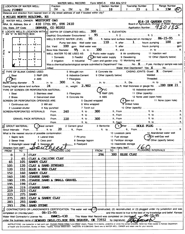
| Location Info | |||
| Owner: Westport Oil and Gas | Status: Constructed | ||
| Location: T23S, R33W, Sec. 18, SW SW SW | County: Finney | ||
| Directions: from Holcomb, 4 mi N | |||
| Latitude: 38.0481257 | Longitude: -100.9915257 | Datum NAD 27 | |
| Latitude: 38.0481497 | Longitude: -100.9919685 | Datum NAD 83 | |
| Longitude and latitude calculated by Survey from township-range-section-quarter calls. Only good to within the quarter call accuracy. | |||
| View well on interactive map | |||
| General Info | ||
| Well Depth: 300 ft. | Elevation: ft. | |
| Static Water Level: 95 ft. | Est. Yield: 100 gpm. | |
| Comp. Date: 15-Jun-1995 | Well Use: Oil Field Water Supply | |
| DWR Applic. #: 950185 | Other ID: Garden City 14-18 | |
| Driller Info | ||
| Driller: Howard Drilling Co. | License #: 430 | |
| Scanned Form | View scan |
|
Chemical Sample Submitted?: No
Water Well disinfected?: | ||
| Ground water encountered: 95 ft. , 0 ft. , 0 ft. | ||
| Pump test data: Well water was 110 ft after 1 hours pumping 100 gpm | ||
| Casing Info | ||
| Casing Type: PVC
Casing Joints: |
Diam: 5 in. to 300 ft
Diam: 0 in. to 0 ft Diam: 0 in. to 0 ft | |
| Casing height above land surface: in
Casing Weight: lbs/ft Wall thickness or gauge no.: | ||
| Screen and Perforation Info | ||
| Screen Type: PVC | Screen Openings: Saw cut | |
| Screen-perforated intervals | From: 240 ft to 300 ft
From: 0 ft to 0 ft From: 0 ft to 0 ft | |
| Gravel pack intervals | From: ft to ft | |
| Grout Info | ||
| Grout used: Neat cement, | From: 1 to 20 ft
From: 0 to 0 ft From: 0 to 0 ft | |
| Source of Possible Contamination | ||
| Source: Oil well/gas well | ||
| Direction from well: SE | Distance: 160 ft | |
| Lithologic Log
(Log data entered by KGS.) | ||
| From: 0 ft. to 2 ft. | clay | |
| From: 2 ft. to 65 ft. | clay and caliche clay | |
| From: 65 ft. to 105 ft. | sandy clay | |
| From: 105 ft. to 120 ft. | clay and sand streaks | |
| From: 120 ft. to 152 ft. | blue and red clay | |
| From: 152 ft. to 160 ft. | sandy clay | |
| From: 160 ft. to 180 ft. | coarse sand | |
| From: 180 ft. to 195 ft. | coarse sand and small gravel | |
| From: 195 ft. to 199 ft. | clay | |
| From: 199 ft. to 219 ft. | coarse sand | |
| From: 219 ft. to 223 ft. | clay | |
| From: 223 ft. to 275 ft. | sand | |
| From: 275 ft. to 283 ft. | clay and sandy clay | |
| From: 283 ft. to 293 ft. | sand | |
| From: 293 ft. to 296 ft. | sandstone | |
| From: 296 ft. to 300 ft. | blue clay | |