|
|
|
Specific Water Well Detail |
|
|
| Location Info | |||
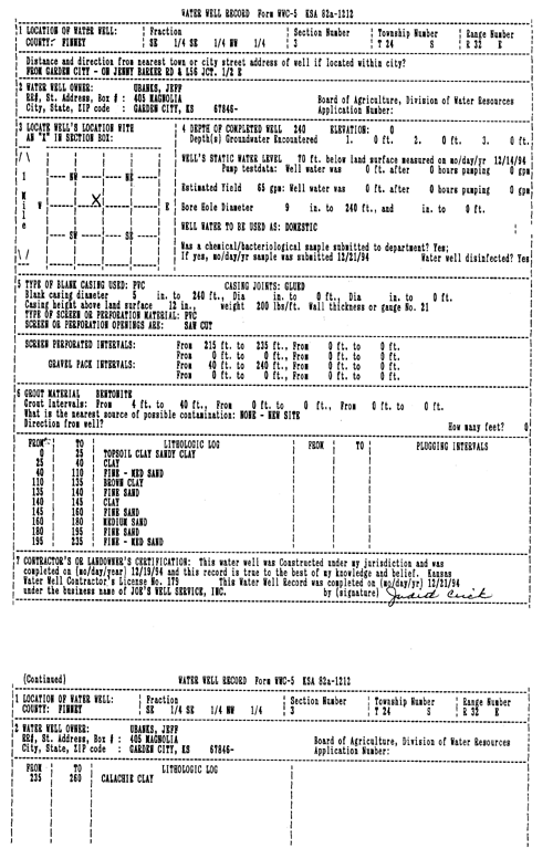
| Owner: Ubanks, Jeff | Status: Constructed | ||
| Location: T24S, R32W, Sec. 3, SE SE NW | County: Finney | ||
| Directions: from Garden City: on Jenny Barker Rd and 56 jct, .5 E | |||
| Latitude: 37.9974379 | Longitude: -100.8206145 | Datum NAD 27 | |
| Latitude: 37.9974603 | Longitude: -100.8210518 | Datum NAD 83 | |
| Longitude and latitude calculated by Survey from township-range-section-quarter calls. Only good to within the quarter call accuracy. | |||
| View well on interactive map | |||
| General Info | ||
| Well Depth: 240 ft. | Elevation: ft. | |
| Static Water Level: 70 ft. | Est. Yield: gpm. | |
| Comp. Date: 19-Dec-1994 | Well Use: Domestic | |
| DWR Applic. #: | Other ID: | |
| Driller Info | ||
| Driller: Joe's Well Service, Inc. | License #: 179 | |
| Scanned Form | View scan |
|
Chemical Sample Submitted?: No
Water Well disinfected?: | ||
| Ground water encountered: 0 ft. , 0 ft. , 0 ft. | ||
| Pump test data: Well water was 0 ft after 0 hours pumping 0 gpm | ||
| Casing Info | ||
| Casing Type: PVC
Casing Joints: |
Diam: 5 in. to 240 ft
Diam: 0 in. to 0 ft Diam: 0 in. to 0 ft | |
| Casing height above land surface: in
Casing Weight: lbs/ft Wall thickness or gauge no.: | ||
| Screen and Perforation Info | ||
| Screen Type: PVC | Screen Openings: Saw cut | |
| Screen-perforated intervals | From: 215 ft to 235 ft
From: 0 ft to 0 ft From: 0 ft to 0 ft | |
| Gravel pack intervals | From: ft to ft | |
| Grout Info | ||
| Grout used: Bentonite | From: 4 to 40 ft
From: 0 to 0 ft From: 0 to 0 ft | |
| Source of Possible Contamination | ||
| Source: OTHER | ||
| Direction from well: | Distance: 0 ft | |
| Lithologic Log
(Log data entered by KGS.) | ||
| From: 0 ft. to 25 ft. | topsoil clay sandy clay | |
| From: 25 ft. to 40 ft. | clay | |
| From: 40 ft. to 110 ft. | fine-medium sand | |
| From: 110 ft. to 135 ft. | brown clay | |
| From: 135 ft. to 140 ft. | fine sand | |
| From: 140 ft. to 145 ft. | clay | |
| From: 145 ft. to 160 ft. | fine sand | |
| From: 160 ft. to 180 ft. | medium sand | |
| From: 180 ft. to 195 ft. | fine sand | |
| From: 195 ft. to 235 ft. | fine-medium sand | |
| From: 235 ft. to 260 ft. | caliche clay | |