|
|
|
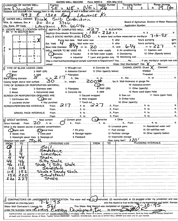
Specific Water Well Detail |
|
|
| Location Info | |||
| Owner: Frank Salb Construction | Status: Constructed | ||
| Location: T14S, R19E, Sec. 26, SE NE NE | County: Douglas | ||
| Directions: 493 E 1300 Rd, Lawrence | |||
| Latitude: 38.8086263 | Longitude: -95.2612907 | Datum NAD 27 | |
| Latitude: 38.8086321 | Longitude: -95.2615418 | Datum NAD 83 | |
| Longitude and latitude calculated by Survey from township-range-section-quarter calls. Only good to within the quarter call accuracy. | |||
| View well on interactive map | |||
| General Info | ||
| Well Depth: 227 ft. | Elevation: ft. | |
| Static Water Level: 100 ft. | Est. Yield: 4 gpm. | |
| Comp. Date: 06-Jul-1995 | Well Use: Domestic | |
| DWR Applic. #: | Other ID: | |
| Driller Info | ||
| Driller: Evans Energy Development, Inc. | License #: 561 | |
| Scanned Form | View scan |
|
Chemical Sample Submitted?: No
Water Well disinfected?: | ||
| Ground water encountered: 220 ft. , 0 ft. , 0 ft. | ||
| Pump test data: Well water was 0 ft after 0 hours pumping 0 gpm | ||
| Casing Info | ||
| Casing Type: PVC
Casing Joints: |
Diam: 5 in. to 217 ft
Diam: 0 in. to 0 ft Diam: 0 in. to 0 ft | |
| Casing height above land surface: in
Casing Weight: lbs/ft Wall thickness or gauge no.: | ||
| Screen and Perforation Info | ||
| Screen Type: PVC | Screen Openings: Mill slot | |
| Screen-perforated intervals | From: 217 ft to 227 ft
From: 0 ft to 0 ft From: 0 ft to 0 ft | |
| Gravel pack intervals | From: ft to ft | |
| Grout Info | ||
| Grout used: Bentonite | From: 0 to 20 ft
From: 0 to 0 ft From: 0 to 0 ft | |
| Source of Possible Contamination | ||
| Source: Septic Tank | ||
| Direction from well: S | Distance: 120 ft | |
| Lithologic Log
(Log data entered by KGS.) | ||
| From: 0 ft. to 1 ft. | soil | |
| From: 1 ft. to 3 ft. | sandstone | |
| From: 3 ft. to 4 ft. | limestone | |
| From: 4 ft. to 44 ft. | shale | |
| From: 44 ft. to 46 ft. | silty shale | |
| From: 46 ft. to 112 ft. | shale and silty shale | |
| From: 112 ft. to 118 ft. | sandstone | |
| From: 118 ft. to 152 ft. | shale and sandy shale | |
| From: 152 ft. to 220 ft. | sandstone | |
| From: 220 ft. to 227 ft. | shale | |