|
|
|
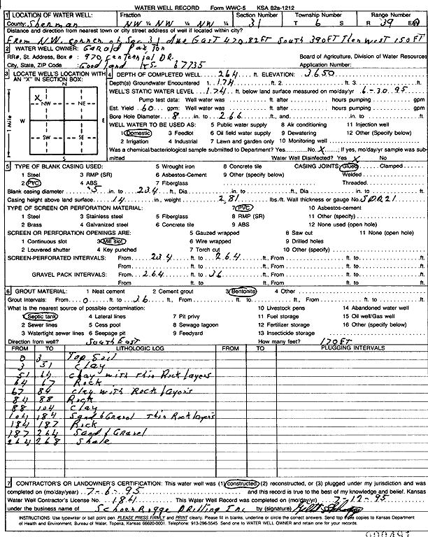
Specific Water Well Detail |
|
|
| Location Info | |||
| Owner: Paxton, Gerold | Status: Constructed | ||
| Location: T6S, R39W, Sec. 31, NW NW NW | County: Sherman | ||
| Directions: From NW corner of Sec. 31; due East 470.82 feet, 390 feet South, then 150 feet West | |||
| Latitude: 39.4952471 | Longitude: -101.7234324 | Datum NAD 27 | |
| Latitude: 39.4952436 | Longitude: -101.723883 | Datum NAD 83 | |
| Longitude and latitude calculated by Survey from township-range-section-quarter calls. Only good to within the quarter call accuracy. | |||
| View well on interactive map | |||
| General Info | ||
| Well Depth: 264 ft. | Elevation: 3650 ft. | |
| Static Water Level: 174 ft. | Est. Yield: 60 gpm. | |
| Comp. Date: 06-Jul-1995 | Well Use: Domestic | |
| DWR Applic. #: | Other ID: | |
| Driller Info | ||
| Driller: Schoenrogge Drilling, Inc. | License #: 184 | |
| Scanned Form | View scan |
|
Chemical Sample Submitted?: No
Water Well disinfected?: | ||
| Ground water encountered: 174 ft. , 0 ft. , 0 ft. | ||
| Pump test data: Well water was 0 ft after 0 hours pumping 0 gpm | ||
| Casing Info | ||
| Casing Type: PVC
Casing Joints: |
Diam: 5 in. to 234 ft
Diam: 0 in. to 0 ft Diam: 0 in. to 0 ft | |
| Casing height above land surface: in
Casing Weight: lbs/ft Wall thickness or gauge no.: | ||
| Screen and Perforation Info | ||
| Screen Type: PVC | Screen Openings: Mill slot | |
| Screen-perforated intervals | From: 234 ft to 264 ft
From: 0 ft to 0 ft From: 0 ft to 0 ft | |
| Gravel pack intervals | From: ft to ft | |
| Grout Info | ||
| Grout used: Bentonite | From: 0 to 36 ft
From: 0 to 0 ft From: 0 to 0 ft | |
| Source of Possible Contamination | ||
| Source: Septic Tank | ||
| Direction from well: SE | Distance: 170 ft | |
| Lithologic Log
(Log data entered by KGS.) | ||
| From: 0 ft. to 3 ft. | Top soil | |
| From: 3 ft. to 51 ft. | Clay | |
| From: 51 ft. to 64 ft. | Clay with thin rock layers | |
| From: 64 ft. to 67 ft. | Rock | |
| From: 67 ft. to 84 ft. | Clay with rock layers | |
| From: 84 ft. to 88 ft. | Rock | |
| From: 88 ft. to 104 ft. | Clay | |
| From: 104 ft. to 184 ft. | Sand and gravel, thin rock layers | |
| From: 184 ft. to 187 ft. | Rock | |
| From: 187 ft. to 264 ft. | Sand and gravel | |
| From: 265 ft. to 268 ft. | Shale | |