|
|
|
Specific Water Well Detail |
|
|
| Location Info | |||
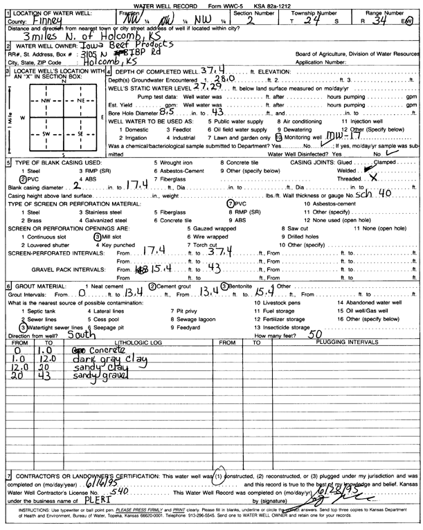
| Owner: Iowa Beef Processors, Inc. | Status: Constructed | ||
| Location: T24S, R34W, Sec. 2, NW NW NW | County: Finney | ||
| Directions: from Holcomb, 3 mi N | |||
| Latitude: 38.002495 | Longitude: -101.0284171 | Datum NAD 27 | |
| Latitude: 38.0025189 | Longitude: -101.0288618 | Datum NAD 83 | |
| Longitude and latitude calculated by Survey from township-range-section-quarter calls. Only good to within the quarter call accuracy. | |||
| View well on interactive map | |||
| General Info | ||
| Well Depth: 37.4 ft. | Elevation: ft. | |
| Static Water Level: 27.29 ft. | Est. Yield: gpm. | |
| Comp. Date: 16-Jun-1995 | Well Use: Monitoring well/observation/piezometer | |
| DWR Applic. #: | Other ID: MW 17 | |
| Driller Info | ||
| Driller: Prairie Land Environmental Remed. | License #: 540 | |
| Scanned Form | View scan |
|
Chemical Sample Submitted?: No
Water Well disinfected?: | ||
| Ground water encountered: 28 ft. , 0 ft. , 0 ft. | ||
| Pump test data: Well water was 0 ft after 0 hours pumping 0 gpm | ||
| Casing Info | ||
| Casing Type: PVC
Casing Joints: |
Diam: 2 in. to 17.4 ft
Diam: 0 in. to 0 ft Diam: 0 in. to 0 ft | |
| Casing height above land surface: in
Casing Weight: lbs/ft Wall thickness or gauge no.: | ||
| Screen and Perforation Info | ||
| Screen Type: PVC | Screen Openings: Mill slot | |
| Screen-perforated intervals | From: 17.4 ft to 37.4 ft
From: 0 ft to 0 ft From: 0 ft to 0 ft | |
| Gravel pack intervals | From: ft to ft | |
| Grout Info | ||
| Grout used: Cement grout, Bentonite | From: 0 to 13.4 ft
From: 13.4 to 15.4 ft From: 0 to 0 ft | |
| Source of Possible Contamination | ||
| Source: Watertight sewer lines | ||
| Direction from well: S | Distance: 50 ft | |
| Lithologic Log
(Log data entered by KGS.) | ||
| From: 0 ft. to 1 ft. | concrete | |
| From: 1 ft. to 12 ft. | dark gray clay | |
| From: 12 ft. to 20 ft. | sandy clay | |
| From: 20 ft. to 43 ft. | sandy gravel | |