|
|
|
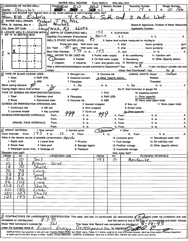
Specific Water Well Detail |
|
|
| Location Info | |||
| Owner: McAfee, Michael T. | Status: Plugged | ||
| Location: T14S, R21E, Sec. 6, SW SW NW | County: Douglas | ||
| Directions: from K-10 Eudora: 4.5 mi S, 2 mi W | |||
| Latitude: 38.8632252 | Longitude: -95.1289892 | Datum NAD 27 | |
| Latitude: 38.8632306 | Longitude: -95.1292372 | Datum NAD 83 | |
| Longitude and latitude calculated by Survey from township-range-section-quarter calls. Only good to within the quarter call accuracy. | |||
| View well on interactive map | |||
| General Info | ||
| Well Depth: 143 ft. | Elevation: ft. | |
| Static Water Level: ft. | Est. Yield: gpm. | |
| Comp. Date: 07-Aug-1995 | Well Use: Domestic | |
| DWR Applic. #: | Other ID: | |
| Driller Info | ||
| Driller: Evans Energy Development, Inc. | License #: 561 | |
| Scanned Form | View scan |
| Casing Info | ||
|
Casing Type: OTHER
Diam: 0 in. Casing height above land surface: in | ||
| Grout Info | ||
| Grout used: Bentonite | From: 0 to 143 ft
From: 0 to 0 ft From: 0 to 0 ft | |
| Source of Possible Contamination | ||
| Source: OTHER | ||
| Direction from well: | Distance: 0 ft | |
| Lithologic Log
(Log data entered by KGS.) | ||
| From: 0 ft. to 10 ft. | soil | |
| From: 10 ft. to 18 ft. | brown sand | |
| From: 18 ft. to 70 ft. | shale | |
| From: 70 ft. to 72 ft. | limestone | |
| From: 72 ft. to 82 ft. | sand | |
| From: 82 ft. to 86 ft. | shale | |
| From: 86 ft. to 102 ft. | limestone | |
| From: 102 ft. to 110 ft. | shale | |
| From: 110 ft. to 120 ft. | limestone | |
| From: 120 ft. to 123 ft. | shale | |
| From: 123 ft. to 143 ft. | limestone | |