|
|
|
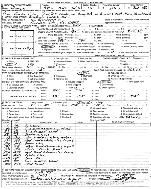
Specific Water Well Detail |
|
|
| Location Info | |||
| Owner: Brookover Farms, Inc. | Status: Constructed | ||
| Location: T25S, R32W, Sec. 15, NW NW SE | County: Finney | ||
| Directions: from Garden City: 7 mi S on Hwy 83, 2.5 mi E, and 0.5 N | |||
| Latitude: 37.8794233 | Longitude: -100.8182725 | Datum NAD 27 | |
| Latitude: 37.8794465 | Longitude: -100.8187109 | Datum NAD 83 | |
| Longitude and latitude calculated by Survey from township-range-section-quarter calls. Only good to within the quarter call accuracy. | |||
| View well on interactive map | |||
| General Info | ||
| Well Depth: 340 ft. | Elevation: ft. | |
| Static Water Level: 134 ft. | Est. Yield: gpm. | |
| Comp. Date: 12-Jul-1995 | Well Use: Domestic | |
| DWR Applic. #: | Other ID: | |
| Driller Info | ||
| Driller: Jantzen Water Well | License #: 533 | |
| Scanned Form | View scan |
|
Chemical Sample Submitted?: No
Water Well disinfected?: | ||
| Ground water encountered: 0 ft. , 0 ft. , 0 ft. | ||
| Pump test data: Well water was 0 ft after 0 hours pumping 0 gpm | ||
| Casing Info | ||
| Casing Type: PVC
Casing Joints: |
Diam: 5 in. to 300 ft
Diam: 0 in. to 0 ft Diam: 0 in. to 0 ft | |
| Casing height above land surface: in
Casing Weight: lbs/ft Wall thickness or gauge no.: | ||
| Screen and Perforation Info | ||
| Screen Type: PVC | Screen Openings: Saw cut | |
| Screen-perforated intervals | From: 300 ft to 340 ft
From: 0 ft to 0 ft From: 0 ft to 0 ft | |
| Gravel pack intervals | From: ft to ft | |
| Grout Info | ||
| Grout used: Bentonite | From: 4 to 24 ft
From: 140 to 145 ft From: 0 to 0 ft | |
| Source of Possible Contamination | ||
| Source: OTHER | ||
| Direction from well: | Distance: 0 ft | |
| Lithologic Log
(Log data entered by KGS.) | ||
| From: 0 ft. to 40 ft. | fine sand | |
| From: 40 ft. to 52 ft. | fine sand and brown clay mixed | |
| From: 52 ft. to 68 ft. | fine to medium sand | |
| From: 68 ft. to 72 ft. | sandrock ledge | |
| From: 72 ft. to 130 ft. | medium sand and sandrock ledges | |
| From: 130 ft. to 140 ft. | medium sand and white clay layers | |
| From: 140 ft. to 144 ft. | brown clay | |
| From: 144 ft. to 162 ft. | medium sand and brown clay layers | |
| From: 162 ft. to 182 ft. | med. - coarse sand | |
| From: 182 ft. to 233 ft. | medium sand and brown clay layers | |
| From: 233 ft. to 240 ft. | brown clay | |
| From: 240 ft. to 285 ft. | brown clay | |
| From: 285 ft. to 300 ft. | fine to medium sand | |
| From: 300 ft. to 340 ft. | medium sand | |