|
|
|
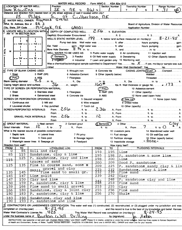
Specific Water Well Detail |
|
|
| Location Info | |||
| Owner: Grafel, Raymond | Status: Constructed | ||
| Location: T1S, R31W, Sec. 1, SE NE NW | County: Rawlins | ||
| Directions: from Culbertson, NE, 15 mi S | |||
| Latitude: 39.9994922 | Longitude: -100.7488134 | Datum NAD 27 | |
| Latitude: 39.999496 | Longitude: -100.7492441 | Datum NAD 83 | |
| Longitude and latitude calculated by Survey from township-range-section-quarter calls. Only good to within the quarter call accuracy. | |||
| View well on interactive map | |||
| General Info | ||
| Well Depth: 256 ft. | Elevation: ft. | |
| Static Water Level: 199 ft. | Est. Yield: gpm. | |
| Comp. Date: 23-Aug-1995 | Well Use: Domestic | |
| DWR Applic. #: | Other ID: | |
| Driller Info | ||
| Driller: Burton Well Drilling, Inc. | License #: 425 | |
| Scanned Form | View scan |
|
Chemical Sample Submitted?: No
Water Well disinfected?: | ||
| Ground water encountered: 0 ft. , 0 ft. , 0 ft. | ||
| Pump test data: Well water was 0 ft after 0 hours pumping 0 gpm | ||
| Casing Info | ||
| Casing Type: PVC
Casing Joints: |
Diam: 4.5 in. to 0 ft
Diam: 0 in. to 0 ft Diam: 0 in. to 0 ft | |
| Casing height above land surface: in
Casing Weight: lbs/ft Wall thickness or gauge no.: | ||
| Screen and Perforation Info | ||
| Screen Type: PVC | Screen Openings: Saw cut | |
| Screen-perforated intervals | From: 236 ft to 256 ft
From: 0 ft to 0 ft From: 0 ft to 0 ft | |
| Gravel pack intervals | From: ft to ft | |
| Grout Info | ||
| Grout used: Bentonite | From: 0 to 7 ft
From: 7 to 12 ft From: 0 to 0 ft | |
| Source of Possible Contamination | ||
| Source: OTHER | ||
| Direction from well: | Distance: 0 ft | |
| Lithologic Log
(Log data entered by KGS.) | ||
| From: 0 ft. to 85 ft. | Soil and clay | |
| From: 85 ft. to 115 ft. | Sandstone, clay, and lime | |
| From: 115 ft. to 125 ft. | Porous sandstone, clay, and lime; traces of sand | |
| From: 125 ft. to 135 ft. | Fine to coarse sand, some small gravel and clay | |
| From: 135 ft. to 145 ft. | Fine sand to small gravel | |
| From: 145 ft. to 147 ft. | Lime, solid | |
| From: 147 ft. to 150 ft. | Clay and lime | |
| From: 150 ft. to 159 ft. | Porous sandstone, clay, and lime | |
| From: 159 ft. to 166 ft. | Fine sand to small gravel | |
| From: 166 ft. to 180 ft. | Sand, clay, and joint clay | |
| From: 180 ft. to 183 ft. | Porous sandstone, clay, and lime | |
| From: 183 ft. to 190 ft. | Sandstone, clay, and lime | |
| From: 190 ft. to 193 ft. | Porous sandstone and lime | |
| From: 193 ft. to 195 ft. | Lime | |
| From: 195 ft. to 198 ft. | Porous sandstone and some lime | |
| From: 198 ft. to 200 ft. | Lime | |
| From: 200 ft. to 209 ft. | Good porous sandstone | |
| From: 209 ft. to 225 ft. | Porous sandstone, sandy clay, and lime | |
| From: 225 ft. to 232 ft. | Sandstone, clay, and lime | |
| From: 232 ft. to 239 ft. | Fine sand | |
| From: 239 ft. to 242 ft. | Clay | |
| From: 242 ft. to 248 ft. | Porous sandstone, sandy clay, and lime | |
| From: 248 ft. to 253 ft. | Fine sand | |
| From: 253 ft. to 255 ft. | Clay | |
| From: 255 ft. to 256 ft. | Fine sand | |
| From: 256 ft. to 270 ft. | Shale | |